1982 North Indian Ocean cyclone season

Last updated

1982 North Indian Ocean cyclone season
1982 North Indian Ocean cyclone season summary.png
Season summary map
Seasonal boundaries
First system formedMay 1, 1982
Last system dissipatedDecember 4, 1982
Strongest storm
NameBOB 01
  Maximum winds215 km/h (130 mph)
(3-minute sustained)
  Lowest pressure940 hPa (mbar)
Seasonal statistics
Depressions19
Deep depressions10
Cyclonic storms5
Severe cyclonic storms5
Very severe cyclonic storms3
Extremely severe cyclonic storms3
Super cyclonic storms0
Total fatalities486
Total damageUnknown
Related articles
North Indian Ocean tropical cyclone seasons
1980, 1981, 1982, 1983, 1984

The 1982 North Indian Ocean cyclone season was an above average season. The season has no official bounds but cyclones tend to form between April and December. These dates conventionally delimit the period of each year when most tropical cyclones form in the northern Indian Ocean. There are two main seas in the North Indian Ocean—the Bay of Bengal to the east of the Indian subcontinent and the Arabian Sea to the west of India. The official Regional Specialized Meteorological Centre in this basin is the India Meteorological Department (IMD), while the Joint Typhoon Warning Center (JTWC) releases unofficial advisories. An average of five tropical cyclones form in the North Indian Ocean every season with peaks in May and November. [1] Cyclones occurring between the meridians 45°E and 100°E are included in the season by the IMD. [2]

Contents

Systems

Extremely Severe Cyclonic Storm BOB 01

Extremely severe cyclonic storm (IMD)
Category 4 tropical cyclone (SSHWS)
01B May 4 1982 0000Z.png   Cyclone 01B 1982 track.png
DurationMay 1 – May 5
Peak intensity215 km/h (130 mph) (3-min);
940  hPa  (mbar)

On April 30 the monsoon trough spawned a tropical depression in the western Bay of Bengal. It tracked northeastward, becoming a tropical storm on the 1st and a cyclone on the 2nd. Its movement became more to the east, and the cyclone continued to quickly intensify, reaching a peak of 145 mph winds just before landfall. The small and compact cyclone hit southern Myanmar on the 4th, and it dissipated the next day over land. Moderate to heavy damage was experienced, but advance warning kept the death toll at only five.

Extremely Severe Cyclonic Storm BOB 02

Extremely severe cyclonic storm (IMD)
Tropical storm (SSHWS)
02B Jun 3 1982 1200Z.png   Cyclone 02B 1982 track.png
DurationMay 31 – June 5
Peak intensity165 km/h (105 mph) (3-min);
952  hPa  (mbar)

Tropical Depression 2B developed from the monsoon trough in the central Bay of Bengal on May 30. It headed northeastward, becoming a tropical storm later that day and reaching a peak of 65 mph winds on the 31st. The storm turned to the northwest, where it weakened to a tropical depression. It restrengthened, and hit near Paradip, India on the 3rd as a 65 mph tropical storm. The storm brought heavy flooding amounting to 140 fatalities and destroying over 500,000 homes. Whole coast of Odisha suffered major damages. Districts of Puri, Cuttack and Balasore were the worst affected among them.

LAND Depression 01

Depression (IMD)
Temporary cyclone north.svg   LAND 01 1982 track.png
DurationJune 17 – June 18
Peak intensity45 km/h (30 mph) (3-min);

Depression ARB 01

Depression (IMD)
Temporary cyclone north.svg   ARB 01 1982 track.png
DurationJuly 15 – July 16
Peak intensity45 km/h (30 mph) (3-min);

Deep Depression BOB 03

Deep depression (IMD)
Temporary cyclone north.svg   BOB 03 1982 track.png
DurationJuly 18 – July 20
Peak intensity55 km/h (35 mph) (3-min);

LAND Depression 02

Depression (IMD)
Temporary cyclone north.svg   LAND 02 1982 track.png
DurationAugust 2 – August 4
Peak intensity45 km/h (30 mph) (3-min);

Depression BOB 04

Depression (IMD)
Temporary cyclone north.svg   BOB 04 1982 track.png
DurationAugust 12 – August 12
Peak intensity45 km/h (30 mph) (3-min);

Depression BOB 05

Depression (IMD)
Temporary cyclone north.svg   BOB 05 1982 track.png
DurationAugust 18 – August 19
Peak intensity45 km/h (30 mph) (3-min);

LAND Depression 03

Depression (IMD)
Temporary cyclone north.svg   LAND 03 1982 track.png
DurationAugust 25 – August 25
Peak intensity45 km/h (30 mph) (3-min);

Depression BOB 06

Depression (IMD)
Temporary cyclone north.svg   BOB 06 1982 track.png
DurationAugust 27 – September 2
Peak intensity45 km/h (30 mph) (3-min);

Depression BOB 07

Depression (IMD)
Temporary cyclone north.svg   BOB 07 1982 track.png
DurationSeptember 9 – September 10
Peak intensity45 km/h (30 mph) (3-min);

Deep Depression BOB 08

Deep depression (IMD)
Temporary cyclone north.svg   BOB 08 1982 track.png
DurationSeptember 29 – September 29
Peak intensity55 km/h (35 mph) (3-min);

Deep Depression ARB 02

Deep depression (IMD)
Temporary cyclone north.svg   ARB 02 1982 track.png
DurationOctober 1 – October 2
Peak intensity55 km/h (35 mph) (3-min);

Severe Cyclonic Storm BOB 09

Severe cyclonic storm (IMD)
Tropical storm (SSHWS)
3B Oct 16 1982 0900Z.png   Cyclone 03B 1982 track.png
DurationOctober 11 – October 17
Peak intensity100 km/h (65 mph) (3-min);
986  hPa  (mbar)

Tropical Storm Three, which formed in the central Bay of Bengal on October 11, hit eastern India on the 16th as a 60 mph tropical storm. It brought considerable damages to Andhra Pradesh and Telangana.

Severe Cyclonic Storm BOB 10

Severe cyclonic storm (IMD)
Tropical storm (SSHWS)
04B Oct 18 1982 2112Z.png   Cyclone 04B 1982 track.png
DurationOctober 16 – October 21
Peak intensity100 km/h (65 mph) (3-min);
982  hPa  (mbar)

An area of convection south of the previous storm slowly organized into a tropical storm on October 16. It tracked northwestward, reaching a peak of 60 mph winds before hitting southeastern India on the 20th as a weakened 50 mph storm. 60 fatalities can be attributed to this system and 400 huts were damaged.

Extremely Severe Cyclonic Storm ARB 03

Extremely severe cyclonic storm (IMD)
Category 2 tropical cyclone (SSHWS)
5A Nov 8 1982 0928Z.png   Cyclone 05A 1982 track.png
DurationNovember 4 – November 9
Peak intensity165 km/h (105 mph) (3-min);
962  hPa  (mbar)

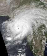
The final storm of the season developed on November 4 in the central Arabian Sea. It tracked northeastward, strengthening into a tropical storm on the 6th and a cyclone on the 7th. The system peaked at 100 mph winds before hitting Veraval, India on the 8th. The cyclone rapidly dissipated, after resulting in 511 fatalities and heavy flooding. Damages were estimated to be 128 crore (equivalent to 24 billionorUS$280 million in 2023).

Deep Depression BOB 11

Deep depression (IMD)
Temporary cyclone north.svg   BOB 11 1982 track.png
DurationNovember 28 – November 29
Peak intensity55 km/h (35 mph) (3-min);

Deep Depression ARB 04

Deep depression (IMD)
Temporary cyclone north.svg   ARB 04 1982 track.png
DurationNovember 28 – November 29
Peak intensity55 km/h (35 mph) (3-min);

Depression BOB 12

Depression (IMD)
Temporary cyclone north.svg   BOB 12 1982 track.png
DurationDecember 2 – December 4
Peak intensity45 km/h (30 mph) (3-min);

See also

References

  1. "Frequently Asked Questions: What is the annual frequency of Cyclones over the Indian Seas? What is its intra-annual variation?". India Meteorological Department. 2012. Archived from the original on May 21, 2015. Retrieved June 8, 2012.
  2. "Bulletins Issued by Regional Specialized Meteorological Centre (RSMC) – Tropical Cyclones, New Delhi" (PDF). India Meteorological Department. May 25, 2009. Archived from the original (PDF) on 2012-04-12. Retrieved July 16, 2012.