1989 North Indian Ocean cyclone season

Last updated

1989 North Indian Ocean cyclone season
1989 North Indian Ocean cyclone season summary.jpg
Season summary map
Seasonal boundaries
First system formedMay 23, 1989
Last system dissipatedNovember 10, 1989
Strongest storm
Name Gay
  Maximum winds230 km/h (145 mph)
(3-minute sustained)
  Lowest pressure930 hPa (mbar)
Seasonal statistics
Depressions10
Cyclonic storms3
Severe cyclonic storms2
Very severe cyclonic storms1
Super cyclonic storms1
Total fatalities1,785 total
Total damage$25.27 million (1989 USD)
Related articles
North Indian Ocean tropical cyclone seasons
1987, 1988, 1989, 1990, 1991

The 1989 North Indian Ocean cyclone season was a below-average season in annual cycle of tropical cyclone formation. Despite this, the season had the second highest Accumulated Cyclone Energy in the basin on record behind only 2019 [1] [2] The season has no official bounds but cyclones tend to form between April and December. These dates conventionally delimit the period of each year when most tropical cyclones form in the northern Indian Ocean. There are two main seas in the North Indian Ocean—the Bay of Bengal to the east of the Indian subcontinent and the Arabian Sea to the west of India. The official Regional Specialized Meteorological Centre in this basin is the India Meteorological Department (IMD), while the Joint Typhoon Warning Center (JTWC) releases unofficial advisories. An average of five tropical cyclones form in the North Indian Ocean every season with peaks in May and November. [3] Cyclones occurring between the meridians 45°E and 100°E are included in the season by the IMD. [4]

Contents

Throughout the season, the IMD monitored ten depressions, three of which became cyclonic storms. [5] The strongest storm of the year was Super Cyclonic Storm Gay. Crossing the Malay Peninsula into the Bay of Bengal on November 4, Gay became one of the most powerful systems on record in the basin, attaining an estimated pressure of 930 mbar (hPa; 27.46 inHg). Collectively, the storms were responsible for at least 1,785 fatalities, 1,445 of which were due to the disastrous flooding triggered by the July Cyclonic Storm, and more than $25 million in damage.

Seasonal summary

Typhoon Gay (1989)1989 North Indian Ocean cyclone season

Systems

Severe Cyclonic Storm BOB 01 (01B)

Severe cyclonic storm (IMD)
Tropical storm (SSHWS)
01B May 26 1989 1343Z.png   Cyclone 01B 1989 track.png
DurationMay 23 – May 27
Peak intensity100 km/h (65 mph) (1-min);
984  hPa  (mbar)

In mid-May, a monsoon trough situated over the Bay of Bengal began showing signs of cyclonic development. By May 20, synoptic data indicated the presence of a weak circulation; however, the system remained disorganized. Following a dramatic increase in convection and organization, the JTWC issued a Tropical Cyclone Formation Alert on May 23 and subsequently began monitoring the system as a tropical depression hours later. Initially, the depression tracked slowly towards the north-northwest before abruptly turning westward and slowing due to weak mid-level steering currents. During this time, the storm gradually intensified and was limited by northwesterly wind shear. By May 26, the storm turned northward and accelerated. Later that day, 01B attained its peak intensity with winds of 100 km/h (60 mph) shortly before making landfall in eastern India. The system quickly weakened once inland and was last noted on May 27 as a dissipating low. [6]

Striking India on May 26, the storm brought wind gusts up to 130 km/h (80 mph) and torrential rains, amounting to 210 mm (8.3 in), which caused widespread damage. [7] [8] The hardest hit area was Midnapore where more than 10,000 homes were destroyed. At least 17 people were killed in the district alone and more than 50,000 were left homeless. [7] Communications across Orissa were severely disrupted as broadcast stations, government buildings, and hundreds of telephone poles were destroyed. [8] Further inland, heavy rains from the storm triggered several landslides that killed at least two people in Darjeeling Hills. [9] Throughout eastern India, 61 people were killed and more than 500,000 were left homeless by the storm. [10] [11]

In nearby Bangladesh, strong winds produced by the storm destroyed 500 homes across 11 villages. [7] Areas devastated by a tornado a month prior were severely affected by the cyclone. In Tangail, a powerful tornado spawned by the storm destroyed 2,000 homes and killed 10 people. [10] At least 60 people perished and 2,000 others were injured across the country. [10] [12] Offshore, 150 fishermen went missing during the storm and were feared dead. [13] In the wake of the storm, widespread search and rescue missions took place in cities flattened by the cyclone. [14]

Depression ARB 01 (02A)

Depression (IMD)
Tropical storm (SSHWS)
2A jun 12 1989 0914Z.jpg   Cyclone 02A 1989 track.png
DurationJune 7 – June 13
Peak intensity65 km/h (40 mph) (1-min);
996  hPa  (mbar)

On June 7, small area of low pressure developed off the west coast of India. Over the following two days, convection associated with the low gradually organized and by June 9, satellite intensity estimates from the JTWC reached 55 km/h (35 mph). A TCFA was subsequently issued for the system before it made landfall in Gujarat early on June 10. Although overland, the low maintained significant convection as it turned westward and through its re-emergence into the Arabian Sea on June 11. Once back over water, convection rapidly spread westward in response to an anticyclone over the Arabian Peninsula and Afghanistan. Early on June 12, the cyclone was estimated to have attained tropical storm status based on a ship report near the center of 65 km/h (40 mph) sustained winds and a surface pressure of 998 mbar (hPa; 29.47 inHg). Later that day, strong wind shear stemming from the anticyclone displaced convection from the tropical storm by more than 110 km (70 mi), prompting the final advisory from the JTWC. The remnants of the system were last noted on June 13, dissipating over the Arabian Sea. [15]

Cyclonic Storm BOB 04

Cyclonic storm (IMD)
Temporary cyclone north.svg  
DurationJuly 21 – July 25
Peak intensity85 km/h (50 mph) (3-min);

On July 22, the IMD began monitoring a depression over the Bay of Bengal. Tracking west-northwest, the system intensified into a cyclonic storm later that day before making landfall in Andhra Pradesh, just north of Vishakhapatnam. Once onshore the storm accelerated towards the northwest and weakened. By July 24, the remnants of the cyclone were located over the state of Maharashtra. The system was last noted the following day over Gujarat and moving into Pakistan. [16]

Across Andhra Pradesh, Orissa, and Uttar Pradesh heavy rains produced by the storm triggered flash flooding and mudslides that killed at least 414 people. [17] According to Chief Minister Nandamuri Taraka Rama Rao, approximately 70,000 homes were destroyed in Andhra Pradesh. While over Maharashtra, the storm produced torrential rainfall, reaching 280 mm (11 in) in 24 hours in Bombay, which caused deadly flash flooding and mudslides. [18] Most of the railway tracks in metropolitan Bombay were left underwater, paralyzing the city and forcing businesses to close for several days. The city's stock exchange remained open, though only sparse trading was observed. [19] Flood waters isolated 46 villages in the region, prompting the deployment of the Indian Army for rescue missions. [18] At least 500 people were killed throughout Maharashtra, more than 200 of which took place in the Raigad district. [20] [21] An unknown number of people were killed after a bridge collapsed with two train carriages on it. [19] Additionally, 75 others were reported missing in the district according to local police. [20] Offshore, 500 fishermen went missing in connection to the storm and are believed to have died. [22]

Flooding rains extended into Pakistan by July 26. [23] Flash floods in the slums outside Karachi killed at least 16 people and washed away 500 huts. An estimated 20,000 people were left homeless in the city. Communication and transportation throughout Karachi was reportedly paralyzed as well due to widespread power outages. Further north in Hyderabad, six others were killed by the storm. [24] Throughout the country, at least 31 people were killed. [25]

Super Cyclonic Storm Gay

Super cyclonic storm (IMD)
Category 5 tropical cyclone (SSHWS)
Gay nov 8 1989 0830Z.jpg   Gay 1989 track.png
DurationNovember 4 (entered basin)  – November 10
Peak intensity230 km/h (145 mph) (3-min);
930  hPa  (mbar)

On November 2, a tropical depression, later named Gay, developed in the Gulf of Thailand and favorable atmospheric conditions allowed the system to undergo rapid intensification. By November 3, Gay had intensified to a Category 3-equivalent typhoon before striking Thailand. [26] Crossing the Kra Isthmus in approximately six hours, the system emerged into the Bay of Bengal as a Category 1-equivalent cyclone and assumed a west-northwesterly track towards India. For the next four days, the storm gradually reorganized before reaching a small area favorable for more significant intensification late on November 6. Hours before making landfall in India, Gay attained its peak intensity as a Category 5-equivalent cyclone with winds estimated at 260 km/h (160 mph). [26] Additionally, the IMD estimated that the storm had three-minute sustained winds of 240 km/h (150 mph), classifying Gay as a modern-day Super Cyclonic Storm. [27] [28] The powerful storm soon made landfall near Kavali, India, in Andhra Pradesh before rapidly weakening onshore. The system eventually dissipated over Maharashtra on November 10. [26]

In Thailand, the storm caused extensive damage both onshore and off, killing 833 people and inflicting approximately

Other systems

In addition to the storms listed above, the IMD monitored six other depressions throughout the year.

Formed in the northern Bay of Bengal and made landfall in Orissa, India. [16]
Formed in the northern Bay of Bengal and made landfall in West Bengal, India. [16]
Formed in the Bay of Bengal and made landfall in Andhra Pradesh, India. [16]
Formed in the Bay of Bengal and made landfall near the India/Bangladesh border. [16] In Bangladesh, heavy rains and high winds, estimated at 60 to 70 km/h (37 to 43 mph), caused significant damage. At least 100 people were injured and 1,000 homes were damaged or destroyed, mainly in the Chandpur District. Following the storm, the Bangladesh Red Crescent Society dispatched four medical teams and relief materials to the affected regions. [34]
Brief depression formed over the Bay of Bengal before dissipating just north of Sri Lanka the same day. [16]
A slow moving depression formed over the Bay of Bengal, northeast of Sri Lanka, and meandered in the same general area for three days before dissipating. [16]

See also

Related Research Articles

<span class="mw-page-title-main">Typhoon Gay</span> Pacific typhoon and North Indian cyclone in 1989

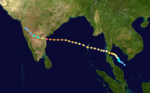
Typhoon Gay, also known as the Kavali Cyclone of 1989, was a small but powerful tropical cyclone which caused more than 800 fatalities in and around the Gulf of Thailand in November 1989. The worst typhoon to affect the Malay Peninsula in thirty-five years, Gay originated from a monsoon trough over the Gulf of Thailand in early November. Owing to favorable atmospheric conditions, the storm rapidly intensified, attaining winds over 120 km/h (75 mph) by 3 November. Later that day, Gay became the first typhoon since 1891 to make landfall in Thailand, striking Chumphon Province with winds of 185 km/h (115 mph). The small storm emerged into the Bay of Bengal and gradually reorganized over the following days as it approached southeastern India. On 8 November, Gay attained its peak intensity as a Category 5-equivalent cyclone with winds of 260 km/h (160 mph). The cyclone then moved ashore near Kavali, Andhra Pradesh. Rapid weakening ensued inland, and Gay dissipated over Maharashtra early on 10 November.

<span class="mw-page-title-main">2005 North Indian Ocean cyclone season</span> Cyclone season in the North Indian ocean

The 2005 North Indian Ocean cyclone season caused much devastation and many deaths in Southern India despite the storms’ weakness. The basin covers the Indian Ocean north of the equator as well as inland areas, sub-divided by the Arabian Sea and the Bay of Bengal. Although the season began early with two systems in January, the bulk of activity was confined from September to December. The official India Meteorological Department tracked 12 depressions in the basin, and the unofficial Joint Typhoon Warning Center (JTWC) monitored two additional storms. Three systems intensified into a cyclonic storm, which have sustained winds of at least 63 km/h (39 mph), at which point the IMD named them.

<span class="mw-page-title-main">1992 North Indian Ocean cyclone season</span>

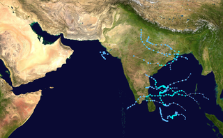
The 1992 North Indian Ocean cyclone season was unofficially the most active year on record for the basin, with 10 tropical storms developing, according to the Joint Typhoon Warning Center (JTWC). There are two main seas in the North Indian Ocean – the Bay of Bengal to the east of the Indian subcontinent – and the Arabian Sea to the west of India. The official Regional Specialized Meteorological Centre in this basin is the India Meteorological Department (IMD), while the JTWC releases unofficial advisories. An average of four to six storms form in the North Indian Ocean every season with peaks in May and November. Cyclones occurring between the meridians 45°E and 100°E are included in the season by the IMD.

<span class="mw-page-title-main">2006 North Indian Ocean cyclone season</span> North Indian Ocean tropical cyclone season

The 2006 North Indian Ocean cyclone season had no bounds, but cyclones tend to form between April and December, with peaks in May and November. These dates conventionally delimit the period of each year when most tropical cyclones form in the northern Indian Ocean.

<span class="mw-page-title-main">2007 North Indian Ocean cyclone season</span> North Indian Ocean tropical cyclone season

The 2007 North Indian Ocean cyclone season was one of the most active North Indian Ocean cyclone seasons on record. The North Indian Ocean cyclone season has no official bounds, but cyclones tend to form between April and December, with peaks in May and November. These dates conventionally delimit the period of each year when most tropical cyclones form in the northern Indian Ocean.

<span class="mw-page-title-main">2008 North Indian Ocean cyclone season</span> North Indian Ocean tropical cyclone season

The 2008 North Indian cyclone season was one of the most disastrous tropical cyclone seasons in modern history, with tropical cyclones leaving more than 140,000 people dead and causing more than US$15 billion in damage. At the time, it was the costliest season in the North Indian Ocean, until it was made second in 2020. The season has no official bounds but cyclones tend to form between April and December. These dates conventionally delimit the period of each year when most tropical cyclones form in the northern Indian Ocean. There are two main seas in the North Indian Ocean—the Bay of Bengal to the east of the Indian subcontinent and the Arabian Sea to the west of India. The official Regional Specialized Meteorological Centre in this basin is the India Meteorological Department (IMD), while the Joint Typhoon Warning Center releases unofficial advisories. An average of four to six storms form in the North Indian Ocean every season with peaks in May and November. Cyclones occurring between the meridians 45°E and 100°E are included in the season by the IMD.

<span class="mw-page-title-main">2000 North Indian Ocean cyclone season</span> Cyclone season in the North Indian ocean

The 2000 North Indian Ocean cyclone season was fairly quiet compared to its predecessor, with all of the activity originating in the Bay of Bengal. The basin comprises the Indian Ocean north of the equator, with warnings issued by the India Meteorological Department (IMD) in New Delhi. There were six depressions throughout the year, of which five intensified into cyclonic storms – tropical cyclones with winds of 65 mph (105 km/h) sustained over 3 minutes. Two of the storms strengthened into a Very Severe Cyclonic Storm, which has winds of at least 120 km/h (75 mph), equivalent to a minimal hurricane. The Joint Typhoon Warning Center (JTWC) also tracked storms in the basin on an unofficial basis, estimating winds sustained over 1 minute.

<span class="mw-page-title-main">1995 North Indian Ocean cyclone season</span> Cyclone season 1995 in the North Indian ocean

The 1995 North Indian Ocean cyclone season was below-average and was primarily confined to the autumn months, with the exception of three short-lived deep depressions in May. There were eight depressions in the basin, which is Indian Ocean north of the equator. The basin is subdivided between the Bay of Bengal and the Arabian Sea on the east and west coasts of India, respectively. Storms were tracked by the India Meteorological Department (IMD), which is the basin's Regional Specialized Meteorological Center, as well as the American-based Joint Typhoon Warning Center (JTWC) on an unofficial basis.

<span class="mw-page-title-main">1996 North Indian Ocean cyclone season</span> Cyclone season in the North Indian Ocean in 1996

The 1996 North Indian Ocean cyclone season featured several deadly tropical cyclones, with over 2,000 people killed during the year. The India Meteorological Department (IMD) – the Regional Specialized Meteorological Center for the northern Indian Ocean as recognized by the World Meteorological Organization – issued warnings for nine tropical cyclones in the region. Storms were also tracked on an unofficial basis by the American-based Joint Typhoon Warning Center, which observed one additional storm. The basin is split between the Bay of Bengal off the east coast of India and the Arabian Sea off the west coast. During the year, the activity was affected by the monsoon season, with most storms forming in June or after October.

<span class="mw-page-title-main">1998 North Indian Ocean cyclone season</span> Cyclone season in the North Indian ocean

The 1998 North Indian Ocean cyclone season was an active season in annual cycle of tropical cyclone formation. The season has no official bounds but cyclones tend to form between April and December. These dates conventionally delimit the period of each year when most tropical cyclones form in the northern Indian Ocean. There are two main seas in the North Indian Ocean—the Bay of Bengal to the east of the Indian subcontinent and the Arabian Sea to the west of India. The official Regional Specialized Meteorological Centre in this basin is the India Meteorological Department (IMD), while the Joint Typhoon Warning Center releases unofficial advisories. An average of four to six storms form in the North Indian Ocean every season with peaks in May and November. Cyclones occurring between the meridians 45°E and 100°E are included in the season by the IMD.

<span class="mw-page-title-main">1990 North Indian Ocean cyclone season</span>

The 1990 North Indian Ocean cyclone season featured a below average total of twelve cyclonic disturbances and one of the most intense tropical cyclones in the basin on record. During the season the systems were primarily monitored by the India Meteorological Department, while other warning centres such as the United States Joint Typhoon Warning Center also monitored the area. During the season, there were at least 1,577 deaths, while the systems caused over US$693 million in damages. The most significant system was the 1990 Andhra Pradesh cyclone, which was the most intense, damaging, and the deadliest system of the season.

<span class="mw-page-title-main">1993 North Indian Ocean cyclone season</span> Cyclone season in the North Indian Ocean in 1993

The 1993 North Indian Ocean cyclone season was the least active on record in the basin, with only four tropical disturbances. There are two main seas in the North Indian Ocean – the Bay of Bengal to the east of the Indian subcontinent and the Arabian Sea to the west. The India Meteorological Department (IMD) issued advisories for the systems in its official capacity as the local Regional Specialized Meteorological Center, while the Joint Typhoon Warning Center also issued advisories for two of the storms on an unofficial basis. Of the five disturbances tracked by the IMD, two intensified into cyclonic storms.

<span class="mw-page-title-main">1994 North Indian Ocean cyclone season</span>

The 1994 North Indian Ocean cyclone season was a below-average year in which eight tropical cyclones affected seven countries bordering the North Indian Ocean. The India Meteorological Department tracks all tropical cyclones in the basin, north of the equator. The first system developed on March 21 in the Bay of Bengal, the first March storm in the basin since 1938. The second storm was the most powerful cyclone of the season, attaining maximum sustained winds of 215 km/h (135 mph) in the northern Bay of Bengal. Making landfall near the border of Bangladesh and Myanmar, the cyclone killed 350 people and left US$125 million in damage.

<span class="mw-page-title-main">Cyclone Rashmi</span>

Cyclonic Storm Rashmi was the seventh tropical cyclone of the 2008 North Indian Ocean cyclone season and second cyclonic storm, as well as the fifth tropical cyclone in the Bay of Bengal that year. A fairly weak tropical cyclone, it caused some notable damage in Bangladesh and India.

<span class="mw-page-title-main">1996 Andhra Pradesh cyclone</span> Category 4 North Indian tropical cyclone in 1996

The 1996 Andhra Pradesh cyclone was a small but powerful storm that left heavy damage in the Indian state of Andhra Pradesh. It formed on 4 November in the eastern Bay of Bengal. Moving westward, it quickly organized and developed a well-defined eye. On 6 November, the cyclone struck about 50 km (31 mi) south of Kakinada, Andhra Pradesh at peak intensity. The India Meteorological Department estimated peak winds of 145 km/h (90 mph), while the American-based Joint Typhoon Warning Center (JTWC) assessed peak winds of 215 km/h (135 mph). Soon after landfall, the cyclone weakened and dissipated by 7 November.

<span class="mw-page-title-main">October 1996 India cyclone</span> North Indian Ocean cyclone in 1996

The October 1996 India cyclone had an unusual and protracted path that spanned much of the northern Indian Ocean. It originated in a weather disturbance that formed on October 14 in the southern Bay of Bengal, off India's east coast. Moving westward, it struck Andhra Pradesh on October 17 as a well-defined low-pressure area. It crossed southern India and reorganized in the Arabian Sea off the western coast of India. The system developed into a depression on October 22 and quickly intensified while moving northward. By October 24, the cyclone approached hurricane intensity as it developed an eye, reaching peak winds of at least 110 km/h (70 mph). On October 25, the storm abruptly stalled and weakened off Gujarat, and progressed southwestward as a minimal storm. It was no longer classifiable as a tropical cyclone by October 28, although its remnants persisted until November 2 when they dissipated east of Somalia.

<span class="mw-page-title-main">1995 India cyclone</span> Category 1 North Indian tropical cyclone in 1995

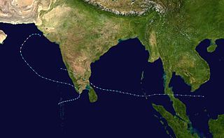
The 1995 India cyclone was a tropical cyclone that struck southeastern India which later spawned a rare snowstorm in Nepal, triggering the deadliest mountain trekking incident in the country's history in November 1995. The storm originated from the monsoon trough on November 7 in the Bay of Bengal, east of India, becoming the penultimate storm of the 1995 North Indian Ocean cyclone season. Moving northwestward, the system gradually intensified while moving toward land, eventually developing an eye in the middle of the convection. Reaching peak winds of at least 120 km/h (75 mph), the India Meteorological Department (IMD) classified the system as a very severe cyclonic storm on November 8, in line with intensity estimates from the American-based Joint Typhoon Warning Center (JTWC). On November 9, the cyclone made landfall near the border of Andhra Pradesh and Orissa. A typical for most November storms, the system continued to the north and dissipated over Nepal on November 11.

<span class="mw-page-title-main">2017 North Indian Ocean cyclone season</span> North Indian Ocean tropical cyclone season

The 2017 North Indian Ocean cyclone season was a below average yet deadly season in the annual cycle of tropical cyclone formation. This season produced only three named storms, of which one only intensified into a very severe cyclonic storm. The North Indian Ocean cyclone season has no official bounds but cyclones tend to form between April and December with the two peaks in May and November. These dates conventionally delimit the period of each year when most tropical cyclones form in the northern Indian Ocean. The season began with the formation Cyclone Maarutha on April 15 and ended with the dissipation of a deep depression on December 9.

<span class="mw-page-title-main">2018 North Indian Ocean cyclone season</span> North Indian Ocean tropical cyclone season

The 2018 North Indian Ocean cyclone season was one of the most active North Indian Ocean cyclone seasons since 1992, with the formation of fourteen depressions and seven cyclones. The North Indian Ocean cyclone season has no official bounds, but cyclones tend to form between April and December, with the two peaks in May and November. These dates conventionally delimit the period of each year when most tropical cyclones form in the northern Indian Ocean.

<span class="mw-page-title-main">Cyclone Titli</span> Deadly tropical cyclone that impacted the East coast of India

Very Severe Cyclonic Storm Titli was a deadly and destructive tropical cyclone that caused extensive damage to Eastern India in October 2018. Titli was the twelfth depression and fifth named storm to form in the 2018 North Indian Ocean cyclone season. Titli originated from a low pressure area in the Andaman Sea on October 7. With warm sea surface temperatures and low wind shear, the low developed into a depression on October 8 in the central Bay of Bengal. It was tracked and followed by the India Meteorological Department (IMD), which also issued warnings and notices for the public. Titli continued to intensify at it moved toward the southeast Indian coast, becoming a very severe cyclonic storm, equivalent to a minimal hurricane on the Saffir–Simpson scale. It attained the intensity at the same time Cyclone Luban in the Arabian Sea was at the same intensity, marking the first instance since 1977 of simultaneous storms. The IMD estimated peak winds of 150 km/h (95 mph), while the American-based Joint Typhoon Warning Center (JTWC) estimated peak winds of 195 km/h (120 mph). Late on October 10, Titli made landfall in Andhra Pradesh, and it quickly weakened over land as it turned to the northeast. It degenerated into a remnant low on October 12.

References

  1. Mohapatra, M.; Vijay Kumar, V. (2016-05-06). "Interannual variation of tropical cyclone energy metrics over North Indian Ocean". Climate Dynamics. 48 (5–6): 1431–1445. doi:10.1007/s00382-016-3150-3. ISSN   0930-7575.
  2. Kotal, S.D.; Bhattacharya, S.K. (March 2020). "Improvement of wind field forecasts for tropical cyclones over the North Indian Ocean". Tropical Cyclone Research and Review. 9 (1): 53–66. doi: 10.1016/j.tcrr.2020.03.004 . ISSN   2225-6032.
  3. "Frequently Asked Questions: What is the annual frequency of Cyclones over the Indian Seas? What is its intra-annual variation?". India Meteorological Department. 2012. Archived from the original on May 21, 2015. Retrieved June 8, 2012.
  4. "Bulletins Issued by Regional Specialized Meteorological Centre (RSMC) – Tropical Cyclones, New Delhi" (PDF). India Meteorological Department. May 25, 2009. Archived from the original (PDF) on 2012-04-12. Retrieved July 16, 2012.
  5. "Annual frequency of cyclonic disturbances (Maximum sustained windspeeds of 17 knots or more), Cyclones (34 knots or more) and Severe Cyclones (48 knots or more) over the Bay of Bengal (BOB), Arabian Sea (AS) and land surface of India" (PDF). India Meteorological Department. August 31, 2010. Archived from the original (PDF) on August 5, 2011. Retrieved March 25, 2012.
  6. Lt. Cdr. Nicholas D. Gural (1990). "1989 Annual Tropical Cyclone Report: Tropical Cyclone 01B" (PDF). Joint Typhoon Warning Center. United States Navy. pp. 188–189. Archived from the original (PDF) on February 21, 2013. Retrieved March 25, 2012.
  7. 1 2 3 "32 Killed, Thousands Homeless in Cyclone". Calcutta. Associated Press. May 27, 1989. (Accessed through LexisNexis)
  8. 1 2 "Cyclone causes widespread damage in India's Orissa coast". New Delhi, India. Xinhua General News. May 27, 1989. (Accessed through LexisNexis)
  9. "Death toll in cyclone rises to 26 in India". New Delhi, India. Xinhua General News. May 29, 1989. (Accessed through LexisNexis)
  10. 1 2 3 "Cyclone Kills 60, Leaves 500,000 Homeless". Dhaka, Bangladesh. Associated Press. May 28, 1989. (Accessed through LexisNexis)
  11. "Historical records of Severe Cyclones which formed in the Bay of Bengal and made landfall at the eastern coast of India during the period from 1970-1999". India Meteorological Department. 1999. Archived from the original on July 17, 2015. Retrieved March 25, 2012.
  12. "Fifty Killed in Cyclone: Toll to Rise". Courier-Mail. Associated Press. May 29, 1989. (Accessed through LexisNexis)
  13. "Cyclone Kills Scores in Bangladesh". Dhaka, Bangladesh. Associated Press. May 29, 1989. (Accessed through LexisNexis)
  14. "Workers Search Rubble in Dhaka After Cyclone". St. Louis Post-Dispatch. Dhaka, Bangladesh. Associated Press. May 29, 1989. p. 8A via LexisNexis.
  15. Lt. Richard H. Bouchard (1990). "1989 Annual Tropical Cyclone Report: Tropical Cyclone 02B" (PDF). Joint Typhoon Warning Center. United States Navy. pp. 190–191. Archived from the original (PDF) on February 21, 2013. Retrieved June 8, 2012.
  16. 1 2 3 4 5 6 7 "Cyclone Web Atlas". Cyclone Warning & Research Centre, Regional Meteorological Centre. Chennai, India: India Meteorological Department. 2012. Archived from the original on July 2, 2012. Retrieved June 7, 2012.
  17. "Ships look for 2,000 missing in floods". The Independent. Bombay, India. Agence France-Presse. July 27, 1989. (Accessed through LexisNexis)
  18. 1 2 "Downpours in Western India Kill at Least 100". Bombay, India. Associated Press. July 24, 1989. (Accessed through LexisNexis)
  19. 1 2 Ajoy Bose (July 27, 1989). "Hundreds feared dead in Indian monsoon flooding". The Guardian. New Delhi, India. (Accessed through LexisNexis)
  20. 1 2 "Death Toll From Storm Tops 450". Bombay, India. Associated Press. July 25, 1989. (Accessed through LexisNexis)
  21. "750 killed as flood situation worsens". The Times of India. New Delhi, India. Xinhua General News. July 26, 1989. (Accessed through LexisNexis)
  22. "Storm toll 800". Hobart Mercury. July 28, 1989. (Accessed through LexisNexis)
  23. "7 killed in heavy Karachi rains". The Muslim. Islamabad, Pakistan. Xinhua General News. July 26, 1989. (Accessed through LexisNexis)
  24. "Rains' death toll rises to 16 in Karachi, Pakistan". Islamabad, Pakistan. Xinhua General News. July 27, 1989. (Accessed through LexisNexis)
  25. "Thousands Dead Throughout Asia In Floods, Mudslides". Beijing, China. Associated Press. July 27, 1989. (Accessed through LexisNexis)
  26. 1 2 3 Lt. Dianne K. Crittenden (1990). "1989 Annual Tropical Cyclone Report: Typhoon Gay (32W)" (PDF). Joint Typhoon Warning Center. United States Navy. pp. 166–172. Archived from the original (PDF) on February 21, 2013. Retrieved June 8, 2012.
  27. G.S. Mandal and Akhilesh Gupta (1996). "The Wind Structure, Size and Damage Potential of Some Recent Cyclone of Hurricane Intensity in the North Indian Ocean". Advances in Tropical Meteorology. New Delhi, India: Indian Meteorological Society (50): 421.
  28. "Cyclones, storm surges, floods, landslides" (PDF). Global Facility for Disaster Reduction and Recovery. September 2011. p. 9. Archived from the original (PDF) on April 26, 2012. Retrieved June 8, 2012.
  29. Vipa Rungdilokroajn (February 1990). Natural Disasters in Thailand (PDF) (Report). Bangkok, Thailand: Universidad Nacional Autónoma de Nicaragua. Archived from the original (PDF) on April 26, 2012. Retrieved December 16, 2011.
  30. "Thailand Country Report". Asian Disaster Reduction Center. 1998. Archived from the original on October 22, 2013. Retrieved December 15, 2011.
  31. "Typhoon Death Toll Rises; 500 Missing Off Thailand Coast". Los Angeles Timesornia. Reuters. November 11, 1989. Retrieved June 8, 2012.
  32. S. Raghavan and S. Rajesh (May 2003). "Trends in Tropical Cyclone Impact: A Study in Andhra Pradesh, India". Bulletin of the American Meteorological Society. 85 (5): 635–644. Bibcode:2003BAMS...84..635R. doi: 10.1175/BAMS-84-5-635 .
  33. "Historical records of Severe Cyclones which formed in the Bay of Bengal and made landfall at the eastern coast of India during the period from 1970–1999". India Meteorological Department. 1999. Archived from the original on July 17, 2015. Retrieved June 8, 2012.
  34. "Storm batters Southeast Bangladesh". Dhaka, Bangladesh. Xinhua General News. October 19, 1989. (Accessed through LexisNexis)