It has been suggested that this article be merged into 1982 Atlantic hurricane season . ( Discuss ) Proposed since December 2025. |
 Beryl near peak intensity on August 31 | |
| Meteorological history | |
|---|---|
| Formed | August 28,1982 |
| Dissipated | September 6,1982 |
| Tropical storm | |
| 1-minute sustained (SSHWS/NWS) | |
| Highest winds | 70 mph (110 km/h) |
| Lowest pressure | 988 mbar (hPa);29.18 inHg |
| Overall effects | |
| Fatalities | 3 direct |
| Damage | $3 million (1982 USD) |
| Areas affected | Cape Verde Islands |
| IBTrACS | |
Part of the 1982 Atlantic hurricane season | |
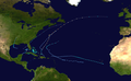
Tropical Storm Beryl was a tropical storm which killed 3 people when it passed just south of the Cape Verde Islands. Beryl,the second named storm of the 1982 Atlantic hurricane season,developed out of a well organized tropical wave which was first noted near Dakar,Senegal on August 27. The wave was declared a tropical depression the next morning and upgraded it to a tropical storm later that same day. Beryl passed 35 mi (56 km) south of the island of Brava,Cape Verde by August 29. Beryl gradually intensified as it moved away from the islands and peaked just short of hurricane status on September 1 with maximum sustained winds of 72 mph (116 km/h). After peaking,Beryl quickly weakened to a tropical depression by the night of September 2. The depression continued on a general path towards the west until is dissipated on September 6 while located to the north of the Leeward Islands.
