Brava, Cape Verde

Last updated • 4 min readFrom Wikipedia, The Free Encyclopedia
Brava
Bela-vista-net-Brava-map.jpg
Locator map of Brava, Cape Verde.png
Cape Verde location map Topographic.png
Red pog.svg
Brava
Atlantic Ocean laea relief location map.jpg
Red pog.svg
Brava
Geography
Location Atlantic Ocean
Coordinates 14°52′N24°42′W / 14.867°N 24.700°W / 14.867; -24.700
Area62.51 km2 (24.14 sq mi)
Length10.5 km (6.52 mi)
Width9.3 km (5.78 mi)
Highest elevation976 m (3202 ft)
Highest point Monte Fontainhas
Administration
MunicipalityBrava
Largest settlement Nova Sintra
Demographics
Population5,698 (2015)
Pop. density91.2/km2 (236.2/sq mi)

Brava (Portuguese for "wild" or "brave") is an island in Cape Verde, and is part of the Sotavento group, in the central Atlantic Ocean. At 62.5 km2 (24.1 sq mi), [1] it is the smallest inhabited island of the Cape Verde archipelago, but at the same time the greenest. First settled in the early 16th century, its population grew after Mount Fogo on neighbouring Fogo erupted in 1680. For more than a century, its main industry was whaling, but the island economy is now primarily agricultural.

Contents

History

Brava was discovered in 1462 by the Portuguese explorer Diogo Afonso. [2] :73 There is no evidence of human presence on the Cape Verde islands before the arrival of the Portuguese. Around 1620 the population of Brava started with the arrival of settlers from Madeira and the Azores. [3] Settlement of Brava took a rise in 1680 when it received many refugees from the nearby larger island of Fogo after its volcano erupted and covered the island with ash. [2] :83–84 Frequent pirate attacks forced the population towards the interior of the island, where the town Nova Sintra was founded around 1700. [3]

Around 1720, the fungus Roccella tinctoria was discovered, which was traded as a textile dye. [3] From the end of the 18th century, whaling ships from North America started hunting whales around the Azores and the Cape Verde Islands. They used the harbours of Brava (Fajã de Água and Furna) to stock up on supplies and drinking water. They hired men from Brava as sailors, and several of these men from Brava settled around the Massachusetts whaling port of New Bedford. [2] :439–440

Geography

The uninhabited islets Ilheus Secos or Ilheus do Rombo with parts of the town of Nova Sintra. Ilheus Secos.jpg
The uninhabited islets Ilhéus Secos or Ilhéus do Rombo with parts of the town of Nova Sintra.

The island of Brava is 10.5 km long (north to south) and its width is 9.3 km. [4] :21 Its area is 62.51 km2 (24.14 sq mi). [1] Practically the whole island is a stratovolcano. It lies in the lee of the enormous Fogo volcano. Volcanic activity on the island has been mainly located along three lines, which all intersect at the crest of ground that forms the highest part of the island. [5] Brava has no documented historical eruptions, but its youthful volcanic morphology and the fact that earthquake swarms still occur indicate the potential for future eruptions; its last eruption was during the Holocene era. 13% of the island area is forested. [4] :25

North of Brava are several uninhabited islets; the largest ones are Ilhéu de Cima and Ilhéu Grande. Monte Fontainhas is the highest point on the island, reaching 976 metres elevation. [6] :25

Climate

Being highly mountainous this island has a quite diverse climate. Brava island has moderate arid climate (BWh according to Köppen–Geiger climate classification system) along the coast and semi-arid mild tropical climate BSh with very balanced temperatures year round in the interior. The average annual temperature on the coast is about 23–25 °C (73–77 °F), decreasing to some 17–20 °C (63–68 °F) in the mountains. There can be remarkably cool weather with warmer wet season starting in June and ending in November with colder dry season starting in December and ending in May.

Climate data for Cachaço, south of Nova Sintra, 800 metres ASL
MonthJanFebMarAprMayJunJulAugSepOctNovDecYear
Mean daily maximum °C (°F)18.7
(65.7)
18.6
(65.5)
19.4
(66.9)
19.8
(67.6)
20.4
(68.7)
21.0
(69.8)
22.2
(72.0)
23.1
(73.6)
23.3
(73.9)
22.6
(72.7)
21.7
(71.1)
19.6
(67.3)
20.9
(69.6)
Daily mean °C (°F)16.2
(61.2)
16.1
(61.0)
16.6
(61.9)
16.9
(62.4)
17.6
(63.7)
18.4
(65.1)
19.4
(66.9)
20.5
(68.9)
20.8
(69.4)
20.4
(68.7)
19.1
(66.4)
17.4
(63.3)
18.3
(64.9)
Mean daily minimum °C (°F)13.8
(56.8)
13.6
(56.5)
13.8
(56.8)
14.1
(57.4)
14.9
(58.8)
15.8
(60.4)
16.7
(62.1)
17.9
(64.2)
18.4
(65.1)
18.2
(64.8)
16.5
(61.7)
15.2
(59.4)
16.9
(62.4)
Average rainfall mm (inches)11
(0.4)
5
(0.2)
1
(0.0)
0
(0)
0
(0)
0
(0)
17
(0.7)
83
(3.3)
123
(4.8)
53
(2.1)
33
(1.3)
20
(0.8)
346
(13.6)
Source: climate-data.org [7]

Municipality

Administratively, the island of Brava is covered by one municipality, Concelho da Brava. This municipality consists of two freguesias (civil parishes): São João Baptista and Nossa Senhora do Monte. The municipal seat is the city Nova Sintra.

Politics

Since 2012, the Movement for Democracy (MpD) is the ruling party of the municipality, and its president is Orlando da Luz Vieira Balla. The results of the latest elections, in 2016: [8]

PartyMunicipal CouncilMunicipal Assembly
Votes%SeatsVotes%Seats
MpD 58.99557.558
PAICV 39.17040.485

Population

Nova Sintra Scn0007.jpg
Nova Sintra

The island's main town is Nova Sintra. The island's two parishes São João Baptista and Nossa Senhora do Monte are subdivided into 16 population zones for statistical purposes: [9]

São João Baptista

Nossa Senhora do Monte

Demographics

In the 1830s, the population was estimated at 8,000. [10]

Population of Brava (1940–2015)
YearPopulation
1940 [11]
8,528
1950 [11]
7,937
1960 [11]
8,625
1970 [11]
7,756
1980 [11]
6,985
1990 [11]
6,975
2000 [11]
6,820
2010 [1]
5,995
2015 [6] :36
5,698

Economy

The economy of the island is mainly based on (irrigated) agriculture and fishing. Main agricultural goods include coffee, potatoes including sweet potatoes, corn (maize), banana and sugar cane. [5]

Attractions

A monument to Eugenio Tavares VilaNovaMonumento.jpg
A monument to Eugênio Tavares

Sports

There are several football clubs on Boa Vista, organised in the Brava Regional Football Association.

Infrastructure

"Aluguer" bus in the village Nossa Senhora do Monte. AluguerEmNossaSra.jpg
"Aluguer" bus in the village Nossa Senhora do Monte.

The Esperadinha Airport, inaugurated in 1992, was closed in 2004 because of persisting strong winds. The village of Furna has a commercial port, the other port is Fajã de Água which is only used for fishing. Ferries to the islands of Fogo and Santiago depart from Furna. On Brava the villages may be reached by "Aluguer" bus. There is no fixed schedule, as the aluguers travel only when there are sufficient passengers. A few taxis are available as well.

Notable residents

Related Research Articles

<span class="mw-page-title-main">Fogo, Cape Verde</span> Island of Cape Verde

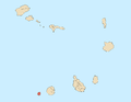
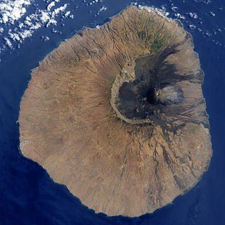
Fogo is an island in the Sotavento group of Cape Verde in the central Atlantic Ocean. Its population is 35,837 (2015), with an area of 476 km2. It reaches the highest altitude of all the islands in Cape Verde, rising to 2,829 metres above sea level at the summit of its active volcano, Pico do Fogo.

<span class="mw-page-title-main">Vila Franca do Campo</span> Municipality in Azores, Portugal

Vila Franca do Campo is a town and municipality in the southern part of the island of São Miguel in the Portuguese Autonomous Region of the Azores. The population of the municipality was 11,229 in 2011, in an area of 77.97 km². The town proper, which incorporates the urbanized parishes São Miguel and São Pedro, has 4100 inhabitants.

<span class="mw-page-title-main">Campanário, Madeira</span> Civil parish in Madeira, Portugal

Campanário is a civil parish in the municipality of Ribeira Brava in the Portuguese island of Madeira. The population in 2011 was 4,582, in an area of 11.74 km².

<span class="mw-page-title-main">Nova Sintra</span> Settlement in Brava, Cape Verde

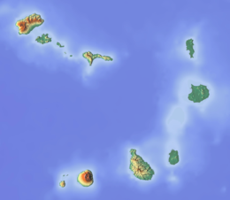
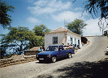
Nova Sintra is a city in the central part of the island of Brava in southwestern Cape Verde. It serves as the seat of the Brava Municipality. The settlement is named after Sintra, the summer residence of the Portuguese kings. Its population is about 1,500. Its elevation is around 500 meters. Since 2010, Nova Sintra has been a city. Agriculture is the predominant source of income on Brava. Tourism is less developed, but there are a few small hotels and guest houses. The "aluguer" buses to the other villages start from Praça Eugénio Tavares.

<span class="mw-page-title-main">Furna (Brava)</span> Settlement in Brava, Cape Verde

Furna is a seaside community in the northeastern part of the island of Brava, Cape Verde. It lies 2.5 km northeast of the island capital of Nova Sintra. At the 2010 census its population was 612.

<span class="mw-page-title-main">Fajã de Água</span> Settlement in Brava, Cape Verde

Fajã de Agua is a village on the northwestern coast of the island of Brava, Cape Verde. It is 4 km west of the island capital Nova Sintra. Fishing and agriculture are the most important sources of income.

<span class="mw-page-title-main">Campo Baixo</span> Settlement in Brava, Cape Verde

Campo Baixo is a small settlement located in the southwestern part of the island of Brava, Cape Verde. In English, the name of the village means 'low field'. Campo Baixo is situated in the mountains, 1.5 km (0.93 mi) southwest of Nossa Senhora do Monte and 4 km (2.5 mi) southwest of the island capital Nova Sintra. From Nossa Senhora do Monte, Campo Baixo is accessible by Aluguer buses.

<span class="mw-page-title-main">Nossa Senhora do Monte, Cape Verde</span> Settlement in Brava, Cape Verde

Nossa Senhora do Monte is a town located in the heart of the island of Brava, Cape Verde. It is the seat of the parish of Nossa Senhora do Monte. Its elevation is 650 m, and its population was 271 in 2010. Nossa Senhora do Monte is surrounded by mountains. Monte Fontainhas, Brava's tallest mountain reaching a height of 976 meters, is close to the village.

<span class="mw-page-title-main">Cova Joana</span> Settlement in Brava, Cape Verde

Cova Joana is a village in the central part of the island of Brava, Cape Verde. It is situated in a mountain valley, 0.5 km north of Nossa Senhora do Monte and 2 km southwest of the island capital Nova Sintra. In 2010 its population was 183. Its elevation is 645 meters.

The Brava Island League is a regional championship played in Brava Island, Cape Verde. The championships are organized by Brava Regional Football Association. The winner of the championship plays in the Cape Verdean football Championships of each season.

São João Baptista is a freguesia of Cape Verde. It covers the eastern part of the island of Brava. The parish seat is Nova Sintra. To its west is the parish of Nossa Senhora do Monte.

Nossa Senhora do Monte is a freguesia of Cape Verde. It covers the western part of the island of Brava. To its east is the parish of São João Baptista.

Nossa Senhora do Rosário is a freguesia of Cape Verde. It covers the larger eastern part of the municipality of Ribeira Brava, on the island of São Nicolau.

<span class="mw-page-title-main">Mosteiros, Cape Verde</span> Settlement in Fogo, Cape Verde

Mosteiros is a city in the northeastern part of the island of Fogo, Cape Verde. It is situated on the coast, 24 kilometres or 15 miles northeast of the island capital São Filipe. It is the seat of the Mosteiros Municipality and of the civil parish Nossa Senhora da Ajuda. At the 2010 census its population was 9,524 making it the island's second most populated place.

<span class="mw-page-title-main">Cova Rodela</span> Settlement in Brava, Cape Verde

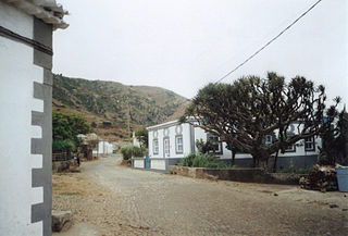
Cova Rodela is a village in the middle of the island of Brava, Cape Verde. The village is situated in the mountains, 1 km west of the island capital Nova Sintra. There are good walking paths to the island's tallest mountain Monte Fontainhas. Most of the inhabitants of the village live on agriculture, growing maize and bananas. In the main street there is a noteworthy old dragon tree. Cova Rodela can be reached easily by aluguer buses from Nova Sintra and from other villages on Brava.

<span class="mw-page-title-main">Architecture of Cape Verde</span>

The Architecture of Cape Verde has different architectural styles in the nation. Unlike the African mainland, Cape Verde was uninhabited until 1461 when the Portuguese arrived, most of the other islands were first inhabited after the end of the 15th century. Its architecture was introduced in the 1460s and has its first origins from Portuguese settlers from the Madeira Islands, after the first arrival of mainland Africans, a bit of African architecture would be elements mainly in rural areas. The Manueline was its first architectural style on the island, it was later followed by Renaissance, Baroque, Pombaline, Early Modern and Modern. It was one of the last in the whole of Africa to introduce architecture late. Cape Verde has one of the richest architecture in the western portion of West Africa, the sub-Saharan portion, the richest probably being Mali.

References

  1. 1 2 3 2010 Census Summary
  2. 1 2 3 Valor simbólico do centro histórico da Praia, Lourenço Conceição Gomes, Universidade Portucalense, 2008, p. 97
  3. 1 2 3 Centre historique de Nova Sintra, UNESCO (in French)
  4. 1 2 Estatísticas do Ambiente – 2016, Instituto Nacional de Estatística
  5. 1 2 "Brava – sua situação geográfica" [Brava, its Geographic Location]. A Semana (in Portuguese). 31 March 2004. Archived from the original on 21 February 2017. Retrieved 10 February 2017.
  6. 1 2 3 4 Cabo Verde, Statistical Yearbook 2015, Instituto Nacional de Estatística
  7. "Climate Cachaço". Climate-Data.org. Retrieved 28 December 2013.
  8. Official results local elections 2016 Archived 2019-08-19 at the Wayback Machine , Boletim Oficial I Série, Número 53, 23 September 2016
  9. "2010 Census results Brava". Instituto Nacional de Estatística Cabo Verde (in Portuguese). 24 November 2016.
  10. Roberts, Edmund (1837). Embassy to the Eastern Courts of Cochin-China, Siam, and Muscat. New York: Harper & Brothers. p. 14.
  11. 1 2 3 4 5 6 7 Source: Statoids

Further reading