Mindelo is a port city in the northern part of the island of São Vicente in Cape Verde. Mindelo is also the seat of the parish of Nossa Senhora da Luz, and the municipality of São Vicente. The city is home to 93% of the entire island's population. Mindelo is known for its colourful and animated carnival celebrations, with roots in Portuguese traditions.

Macaronesia is a collection of four archipelagos in the North Atlantic Ocean off the coast of the continents of Europe and Africa. Each archipelago is made up of a number of Atlantic oceanic islands formed by seamounts on the ocean floor with peaks above the ocean's surface. The Macaronesian islands belong to three countries: Portugal, Spain, and Cape Verde. Politically, the islands belonging to Portugal and Spain are part of the European Union. Geologically, Macaronesia is part of the African Plate, including the Azores, which mark its edge at the meeting point with the Eurasian and American Plates.
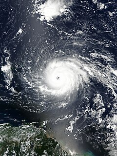
A Cape Verde hurricane, or Cabo Verde hurricane is an Atlantic hurricane that originates at low-latitude in the deep tropics from a tropical wave that has passed over or near the Cape Verde islands after exiting the coast of West Africa. The average hurricane season has about two Cape Verde hurricanes, which are often the largest and most intense storms of the season due to having plenty of warm open ocean over which to develop before encountering land or other factors prompting weakening. A good portion of Cape Verde storms are large, and some, such as Hurricane Ivan and Hurricane Irma, have set various records. Most of the longest-lived tropical cyclones in the Atlantic basin are Cape Verde hurricanes. While many move harmlessly out to sea, some move across the Caribbean sea and into the Gulf of Mexico, becoming damaging storms for Caribbean nations, Central America, Mexico, Bermuda, the United States, and occasionally even Canada. Research projects since the 1970s have been launched to understand the formation of these storms.
The Cape Verde national football team, nicknamed either the Tubarões Azuis or Crioulos (Creoles), is the national team of Cape Verde and is controlled by the Cape Verdean Football Federation.

Boa Vista, also written as Boavista, is a desert-like island that belongs to the Cape Verde Islands. At 631.1 km2 (243.7 sq mi), it is the third largest island of the Cape Verde archipelago.

Santiago is the largest island of Cape Verde, its most important agricultural centre and home to half the nation’s population. Part of the Sotavento Islands, it lies between the islands of Maio and Fogo. It was the first of the islands to be settled: the town of Ribeira Grande was founded in 1462. Santiago is home to the nation's capital city of Praia.

Calheta de São Miguel is a city in the northern part of the island of Santiago, Cape Verde. In 2010 its population was 3,175. It is situated on the east coast, 31 km north of the capital Praia. It is the seat of São Miguel municipality.

Porto Inglês is a city in the southwestern part of the island of Maio in southeastern Cape Verde. It is the main urban settlement of the island, and also seat of the Maio Municipality. Its population was 2,971 in 2010. The name Porto Inglês refers to English ships that exported salt produced on the island of Maio from this town. Salt exploitation continued until the 19th century. The inconclusive Battle of Maio was fought between British and French frigate squadrons close to the town on 23 January 1814 in the last stages of the Napoleonic Wars.

Achada Furna is a settlement in the southern part of the island of Fogo, Cape Verde. It is situated 15 km east of the island capital São Filipe. At the 2010 census its population was 495. Its elevation is about 870 meters. Nearby places include Cabeça Fundão to the north, Figueira Pavão to the east, Fonte Aleixo to the south and Monte Largo to the west.

Figueira Pavão is a settlement in the southeastern part of the island of Fogo, Cape Verde. In 2010 its population was 320. It is situated 3 km southwest of Cova Figueira and 20 km east of the island capital São Filipe. Nearby settlements are Achada Furna to the west and Estância Roque to the north.

Achadinha is a subdivision of the city of Praia in the island of Santiago, Cape Verde. Its population was 8,483 at the 2010 census. It is situated north of the city centre. Adjacent neighbourhoods include Bairro Craveiro Lopes to the south, Fazenda in the east, Achada Eugênio Lima in the west and Calabaceira in the north, on the other side of the Ribeira da Trindade.

Fontainhas is a settlement in the northern part of the island of Santo Antão, Cape Verde. It is situated near the rocky north coast of the island, 2 km southwest of Ponta do Sol and 19 km north of the island capital Porto Novo. The settlement includes the smaller villages Corvo and Forminguinhas, about 1 km west of Fontainhas proper.

Pombas is a city in the northeastern part of the island of Santo Antão, Cape Verde. It is the seat of the municipality Paul. It is situated on the coast, at the mouth of the Ribeira do Paul, 7 km (4.3 mi) southeast of Ribeira Grande and 15 km (9.3 mi) north of the island capital Porto Novo. The national roads EN1-SA02 and EN1-SA03 connect Pombas with Ribeira Grande and Porto Novo, respectively. Pombas was elevated from town to city in 2010.

Chã de Igreja is a town in the northern part of the island of Santo Antão, Cape Verde. It is situated near the north coast of the island, in the valley of the river Ribeira da Garça, 19 km northwest of the island capital Porto Novo. In 2010 its population was 672. The nature reserve Cruzinha, which includes the small seaside village Cruzinha da Garça, stretches northeast of Chã de Igreja along the coast.

Calheta is a town in the western part of the island of Maio. It is situated on the Atlantic coast, around 11 km north of the island capital Porto Inglês and 6 km north of Morro. Its population at the 2010 census was 1,156, making it the island's second most populous settlement. The settlement was mentioned as "Kalyete" in the 1747 map by Jacques-Nicolas Bellin.
Morro is a settlement in the west of the island of Maio in Cape Verde. It is located 5 km north of the island capital Porto Inglês and 6 km south of Calheta. As of the 2010 census, its population was 310. The beach north of the village, Praia do Morro, is a 6.66 km2 nature reserve.
The 2010 Cape Verdean Football Championship season was the 31st of the competition of the first-tier football in Cape Verde. Its started on 8 May, slightly later than the last season and finished on 10 July, later than last year. The tournament was organized by the Cape Verdean Football Federation. It was the second consecutive time that the final featured two clubs from the same island and city, the next time it happened would be five years later. It brought the Capital Rivalry between Sporting and Boavista to the national championships. Another club of Praia named Boavista FC winning the national title breaking Sporting Praia's consecutive title wins. A month later, Boavista Praia would become the only club to win both the championship and the cup title in the same season.
As Hortas is a settlement in the northwestern part of the island of Fogo, Cape Verde. It is situated 2 km west of Curral Grande, 3 km southwest of Ponta Verde and 8 km north of the island capital São Filipe.

Tinteira is a settlement in the eastern part of the island of Fogo, Cape Verde. It is situated 4 km north of Cova Figueira, 5 km south of Relva and 22 km east of the island capital São Filipe. At the 2010 census its population was 410. Its elevation is 300 meters. Tinteira consists of the localities Tinteira, Cova Matinho and Cutelo Capado.