The recorded history of Cape Verde begins with Portuguese discovery in 1456. Possible early references go back around 2000 years.

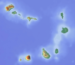
Fogo is an island in the Sotavento group of Cape Verde. Its population is 35,837 (2015), with an area of 476 km². It reaches the highest altitude of all the islands in Cape Verde, rising to 2,829 metres above sea level at the summit of its active volcano, Pico do Fogo.

Eugénio de Paula Tavares was a Cape Verdean poet. He is known through his famous poems (mornas), written in the Crioulo of Brava.

Santa Luzia is an island of the Barlavento archipelago in Cape Verde located between São Nicolau and São Vicente, the channel of Santa Luzia separates the island of São Vicente and is 8 km wide. The area is 34.2 km². Like all Cape Verdean islands, it is of volcanic origin. The highest point is Topona. Santa Luzia is 12.4 km long and 5.3 km wide.

São Nicolau is one of the Barlavento (Windward) islands of Cape Verde. It is located between the islands of Santa Luzia and Sal. Its population is 12,424 (2015), with an area of 343 km². The main towns are Ribeira Brava and Tarrafal de São Nicolau.

Santiago is the largest island of Cape Verde, its most important agricultural centre and home to half the nation’s population. Part of the Sotavento Islands, it lies between the islands of Maio and Fogo. It was the first of the islands to be settled: the town of Ribeira Grande was founded in 1462. Santiago is home to the nation's capital city of Praia.

Tarrafal de São Nicolau is a city in the western part of the island of São Nicolau, Cape Verde. With a population of 3,733, it is the most populous settlement of the island. It is the seat of the Tarrafal de São Nicolau Municipality, and the main port of the island. It is situated on the west coast, 9 km southwest of Ribeira Brava.
Monte Gordo is a mountain on the island of São Nicolau, Cape Verde. At 1,312 m elevation, it is the island's highest point. It is situated in the western part of the island, 6 km west of the island capital Ribeira Brava. The mountain is of volcanic origin, less than 1 million years old. The boundary of the municipalities Tarrafal de São Nicolau and Ribeira Brava runs over the mountain. It is part of the Monte Gordo Natural Park.

Mato Grande is a settlement in the island of Brava, Cape Verde. It is situated in the mountains, 1 km southeast of the island capital Nova Sintra.

Furna is a seaside community in the northeastern part of the island of Brava, Cape Verde. It lies 2.5 km northeast of the island capital of Nova Sintra. At the 2010 census its population was 612.

Fajã de Agua is a village on the northwestern coast of the island of Brava, Cape Verde. It is 4 km west of the island capital Nova Sintra. Fishing and agriculture are the most important sources of income.
Tantum or Lomba Tantum is a small settlement located in the southwest corner of the island Brava, Cape Verde. It is one of the southernmost settlements in Cape Verde, together with nearby Cachaço. Its 2010 population was 282. It sits at an elevation of 228 meters. It is situated in the mountains near the south coast, 6 km southwest of the island capital Nova Sintra.

Nossa Senhora do Monte is a town located in the heart of the island of Brava, Cape Verde. It is the seat of the parish of Nossa Senhora do Monte. Its elevation is 650 m, and its population was 271 in 2010. Nossa Senhora do Monte is surrounded by mountains. Monte Fontainhas, Brava's tallest mountain reaching a height of 976 meters, is close to the village.

Cova Joana is a village in the central part of the island of Brava, Cape Verde. It is situated in a mountain valley, 0.5 km north of Nossa Senhora do Monte and 2 km southwest of the island capital Nova Sintra. In 2010 its population was 183. Its elevation is 645 meters.
Cachaço is a village on the island of Brava, Cape Verde. It is situated in the mountains, 4 km south of the island capital Nova Sintra. In 2010 its population was 228. Its elevation is 592 meters. Cachaço is the second southernmost settlement in Cape Verde, after nearby Tantum. Some 4 km south is the southernmost point in Cape Verde, Ponta Nhô Martinho.

Ilhéu de Cima is an uninhabited island of Cape Verde. It is part of the Ilhéus do Rombo islet group, located 4 km east of Ilhéu Grande, the other main islet of the group, and 8 km northeast of the island Brava. They are administratively a part of the Brava municipality. Surrounding islets include Ilhéu Luiz Carneiro, Ilhéu Sapado and Ilhéu do Rei. The island is part of the integral nature reserve Ilhéus do Rombo, famous for its seabirds colonies.

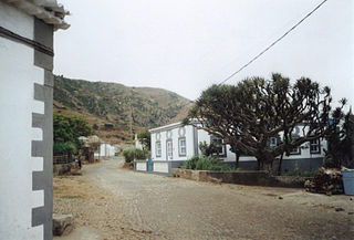
Ribeira Brava is a city on the island of São Nicolau, Cape Verde. It is the seat of the Ribeira Brava Municipality. Its population was 1,936 at the 2010 census. The town is situated in the valley of the river Ribeira Brava, east of the main mountain range of the island. The name of the river is Portuguese for "rough stream", referring to the violent behaviour of the river during rains. The city has a colonial look with Portuguese style buildings, charming parks and gardens, small winding streets, and steep hills.
Cova Rodela is a village in the middle of the island of Brava, Cape Verde. The village is situated in the mountains, 1 km west of the island capital Nova Sintra. There are good walking paths to the island's tallest mountain Monte Fontainhas. Most of the inhabitants of the village live on agriculture, growing maize and bananas. In the main street there is a noteworthy old dragon tree. Cova Rodela can be reached easily by aluguer buses from Nova Sintra and from other villages on Brava.

Cape Verde was a colony of the Portuguese Empire from the initial settlement of the Cape Verde Islands in 1462 until the independence of Cape Verde in 1975.