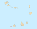
Brava is an island in Cape Verde, and is part of the Sotavento group, in the central Atlantic Ocean. At 62.5 km2 (24.1 sq mi), it is the smallest inhabited island of the Cape Verde archipelago, but at the same time the greenest. First settled in the early 16th century, its population grew after Mount Fogo on neighbouring Fogo erupted in 1680. For more than a century, its main industry was whaling, but the island economy is now primarily agricultural.

Eugénio de Paula Tavares was a Cape Verdean poet. He is known through his famous poems (mornas), mostly written in the Creole of Brava.

São Filipe is a city on the west coast of the island of Fogo, Cape Verde. It is the capital of the island, and the seat of the São Filipe Municipality. The island's airport, São Filipe Airport, is located on the southeastern edge of the town and the island's port is 4 km north of the center at Vale de Cavaleiros. The town's elevation is 20 meters.

Santa Catarina is a concelho (municipality) of Cape Verde. It is situated in the western part of the island of Santiago. Its seat is the city of Assomada. Its population was 45,920 in 2017 (estimate). Its area is 242.6 km2 (93.7 sq mi).

Tarrafal de São Nicolau is a city in the western part of the island of São Nicolau, Cape Verde. With a population of 3,733, it is the most populous settlement of the island. It is the seat of the Tarrafal de São Nicolau Municipality, and the main port of the island. It is situated on the west coast, 9 km southwest of Ribeira Brava.
Mato Grande is a settlement in the island of Brava, Cape Verde. It is situated in the mountains, 1 km southeast of the island capital Nova Sintra.

Furna is a seaside community in the northeastern part of the island of Brava, Cape Verde. It lies 2.5 km northeast of the island capital of Nova Sintra. At the 2010 census its population was 612.

Fajã de Agua is a village on the northwestern coast of the island of Brava, Cape Verde. It is 4 km west of the island capital Nova Sintra. Fishing and agriculture are the most important sources of income.

Campo Baixo is a small settlement located in the southwestern part of the island of Brava, Cape Verde. In English, the name of the village means 'low field'. Campo Baixo is situated in the mountains, 1.5 km (0.93 mi) southwest of Nossa Senhora do Monte and 4 km (2.5 mi) southwest of the island capital Nova Sintra. From Nossa Senhora do Monte, Campo Baixo is accessible by Aluguer buses.
Tantum or Lomba Tantum is a small settlement located in the southwest corner of the island Brava, Cape Verde. It is one of the southernmost settlements in Cape Verde, together with nearby Cachaço. Its 2010 population was 282. It sits at an elevation of 228 metres (748 ft). It is situated in the mountains near the south coast, 6 km (3.7 mi) southwest of the island capital Nova Sintra.

Nossa Senhora do Monte is a town located in the heart of the island of Brava, Cape Verde. It is the seat of the parish of Nossa Senhora do Monte. Its elevation is 650 m, and its population was 271 in 2010. Nossa Senhora do Monte is surrounded by mountains. Monte Fontainhas, Brava's tallest mountain reaching a height of 976 meters, is close to the village.

Cova Joana is a village in the central part of the island of Brava, Cape Verde. It is situated in a mountain valley, 0.5 km north of Nossa Senhora do Monte and 2 km southwest of the island capital Nova Sintra. In 2010 its population was 183. Its elevation is 645 meters.
Mato is a settlement in the island of Brava, Cape Verde. It is situated in the mountainous interior of the island, 2 km southwest of the island capital Nova Sintra.
Cachaço is a village on the island of Brava, Cape Verde. It is situated in the mountains, 4 km south of the island capital Nova Sintra. In 2010 its population was 228. Its elevation is 592 meters. Cachaço is the second southernmost settlement in Cape Verde, after nearby Tantum. Some 4 km south is the southernmost point in Cape Verde, Ponta Nhô Martinho.

Santa Bárbara is a village in the northeastern part of the island of Brava, Cape Verde. It is situated at 350 m elevation, close to the Atlantic coast. It is about 1 kilometer east of the island capital of Nova Sintra. To its southeast is the small village of Vinagre. Santa Bárbara can be reached by "Aluguer" buses.
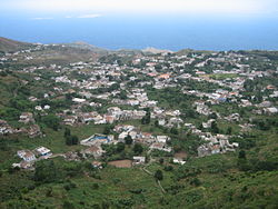
São João Baptista is a freguesia of Cape Verde. It covers the eastern part of the island of Brava. The parish seat is Nova Sintra. To its west is the parish of Nossa Senhora do Monte.

Mosteiros is a city in the northeastern part of the island of Fogo, Cape Verde. It is situated on the coast, 24 kilometres or 15 miles northeast of the island capital São Filipe. It is the seat of the Mosteiros Municipality and of the civil parish Nossa Senhora da Ajuda. At the 2010 census its population was 9,524 making it the island's second most populated place.
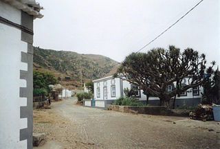
Cova Rodela is a village in the middle of the island of Brava, Cape Verde. The village is situated in the mountains, 1 km west of the island capital Nova Sintra. There are good walking paths to the island's tallest mountain Monte Fontainhas. Most of the inhabitants of the village live on agriculture, growing maize and bananas. In the main street there is a noteworthy old dragon tree. Cova Rodela can be reached easily by aluguer buses from Nova Sintra and from other villages on Brava.
Vinagre is a village in the eastern part of the island of Brava, Cape Verde. It is situated at 200 m elevation, close to the Atlantic coast. It is about 3 kilometer east of the island capital of Nova Sintra, northwest is the small village of Santa Bárbara
Lem is a settlement located in the north of the island Brava, Cape Verde, just 1 km north of the island capital Nova Sintra. Its population in 2010 was 282.