Luis Muñoz Marín International Airport (LMM), previously known as the Isla Verde International Airport, is the primary international airport of Puerto Rico serving the capital municipality of San Juan and its metropolitan area. Covering 1,600 acres, SJU is located in the beach-front district of Isla Verde in the municipality of Carolina. Named after Luis Muñoz Marín, the first elected governor of the archipelago and island, it is, as of 2023, the 39th busiest airport by passenger boarding, 28th by international passenger traffic, and 24th by cargo throughput within the United States. With 12,197,553 million passengers in 2023, SJU is the busiest airport in the Caribbean, where it serves as a major gateway into the region.

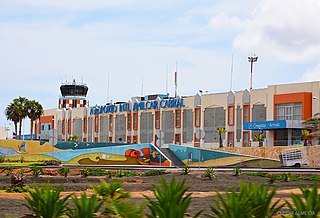
Amílcar Cabral International Airport, also known as Sal International Airport, is the main international airport of Cape Verde. The airport is named after the revolutionary leader Amílcar Cabral. It is located two km west-southwest from Espargos on Sal Island. Sal is the main hub for the national airline, Cabo Verde Airlines; and serves as a base for carrier Cabo Verde Express. This airport was also one of NASA's locations for a facility to handle the Space Shuttle after reentering from orbit.

Nelson Mandela International Airport, also known as Praia International Airport, is an international airport of Santiago Island in Cape Verde. It was opened in October 2005, replacing the old Francisco Mendes International Airport. It is located about 3 km (1.9 mi) northeast of the city centre of Praia in the southeastern part of the island of Santiago.

Fajã de Agua is a village on the northwestern coast of the island of Brava, Cape Verde. It is 4 km west of the island capital Nova Sintra. Fishing and agriculture are the most important sources of income.

Cesária Évora Airport is Cape Verde's fourth-busiest airport, located on the island of São Vicente, nearly 5 kilometres (3.1 mi) from the centre of Mindelo. It is located in the valley area in the west of the island and is north of the village of São Pedro. Its runway is 2,000 metres (6,600 ft) long and its width is 45 metres (148 ft)

Aristides Pereira International Airport is an airport in Cape Verde located on the island of Boa Vista, about 5 km (3.1 mi) southeast of the island capital Sal Rei. It is the third-busiest airport in the country.

The economy of Cape Verde is a service-oriented economy that is focused on commerce, trade, transport and public services. Cape Verde is a small archipelagic nation that lacks resources and has experienced severe droughts. Agriculture is made difficult by lack of rain and is restricted to only four islands for most of the year. Cape Verde's economy has been steadily growing since the late 1990s, and it is now officially considered a country of average development, being only the second African country to have achieved such transition, after Botswana in 1994. Cape Verde has significant cooperation with Portugal at every level of the economy, which has led it to link its currency first to the Portuguese escudo and, in 1999, to the euro.

Cape Verde or Cabo Verde, officially the Republic of Cabo Verde, is an island country and archipelagic state of West Africa in the central Atlantic Ocean, consisting of ten volcanic islands with a combined land area of about 4,033 square kilometres (1,557 sq mi). These islands lie between 600 and 850 kilometres west of Cap-Vert, the westernmost point of continental Africa. The Cape Verde islands form part of the Macaronesia ecoregion, along with the Azores, the Canary Islands, Madeira and the Savage Isles.
Batouri Airport is a public use airport located 5 kilometres (3 mi) north of Batouri, Est, Cameroon.
Bertoua Airport is a public use airport located 5 kilometres (3 mi) east-southeast of Bertoua, Est, Cameroon.
Dschang Airport is a public use airport located 0 kilometres (0 mi) south-southeast of Dschang, Ouest, Cameroon.
Kaélé Airport is a public use airport located near Kaélé, Extrême-Nord, Cameroon.
Kribi Airport is a public use airport located 10 kilometres (6 mi) southeast of Kribi, on the Gulf of Guinea, in the Océan Department, Sud Region, Cameroon.
Mamfe Airport is a public use airport located 5 kilometres (3 mi) south of Mamfe, Sud-Ouest, Cameroon. The airport is actually found in Besongabang – a village about 5 km (3 mi) from Mamfe town. The Cameroon military base in Besongabang shares the airport.
Yagoua Airport is a public use airport located near Yagoua, Extrême-Nord, Cameroon.
Cape Eleuthera Airport was a public use airport located 3 nm east-southeast of Cape Eleuthera, The Bahamas. The airport is closed, and the runway is not usable.
Cape Santa Maria Airport was a PRIVATE use ONLY se airport located near Cape Santa Maria, the Bahamas.It is on private land and is not in any way affiliated with the nearby Cape Santa Maria Resort. The nearest usable airport is Stella Maris SML, about 20 minutes away.
Monte Verde Airport is an airstrip serving the agricultural land around Monte Verde in the Santa Cruz Department of Bolivia.
Mondulkiri Airport is a public use airport located near Senmonorom, Môndól Kiri, Cambodia.
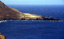
Mosteiros Airport was a public use airfield near Mosteiros, in the northeastern part of the island Fogo, Cape Verde. The airfield operated at least since 1957 when Aero Clube de Cabo Verde opened a new air route to MTI/GVMT, with a Dove airplane which could transport 9 passengers. The airfield was closed at the end of the 1990s. Since then, the only airfield of Fogo is São Filipe Airport. Mosteiros Airport was located at the northwestern edge of the city of Mosteiros.


