Cova Joana

Last updated
Cova Joana
CovaJoanaRuaPrincipal.jpg
Cova Joana, Main Street
Cape Verde location map.svg
Red pog.svg
Coordinates: 14°51′47″N24°42′47″W / 14.863°N 24.713°W / 14.863; -24.713 Coordinates: 14°51′47″N24°42′47″W / 14.863°N 24.713°W / 14.863; -24.713
Country Cape Verde
Island Brava
Municipality Brava
Civil parish Nossa Senhora do Monte
Elevation 645 m (2,116 ft)
Population (2010) [1]
  Total 183

Cova Joana is a village in the central part of the island of Brava, Cape Verde. It is situated in a mountain valley, 0.5 km north of Nossa Senhora do Monte and 2 km southwest of the island capital Nova Sintra. In 2010 its population was 183. Its elevation is 645 meters.

Brava, Cape Verde island of the Cape Verde archipelago

Brava is an island in Cape Verde, in the Sotavento group. At 62.5 km2 (24.1 sq mi), it is the smallest inhabited island of the Cape Verde archipelago, but at the same time the greenest. First settled in the early 16th century, its population grew after Mount Fogo on neighbouring Fogo erupted in 1680. For more than a century, its main industry was whaling, but the island economy is now primarily agricultural.

Cape Verde Country comprising ten islands off the Northwest coast of Africa

Cape Verde or Cabo Verde, officially the Republic of Cabo Verde, is an island country spanning an archipelago of 10 volcanic islands in the central Atlantic Ocean. It forms part of the Macaronesia ecoregion, along with the Azores, Canary Islands, Madeira, and the Savage Isles. In ancient times these islands were referred to as "the Islands of the Blessed" or the "Fortunate Isles". Located 570 kilometres (350 mi) west of the Cape Verde Peninsula off the coast of Northwest Africa, the islands cover a combined area of slightly over 4,000 square kilometres (1,500 sq mi).

Nossa Senhora do Monte, Cape Verde Settlement in Brava, Cape Verde

Nossa Senhora do Monte is a town located in the heart of the island of Brava, Cape Verde. It is the seat of the parish of Nossa Senhora do Monte. Its elevation is 650 m, and its population was 271 in 2010. Nossa Senhora do Monte is surrounded by mountains. Monte Fontainhas, Brava's tallest mountain reaching a height of 976 meters, is close to the village.

Description

Aluguer bus on Brava. AluguerEmNossaSra.jpg
Aluguer bus on Brava.

The name of the village Cova Joana refers to the location, as the creole word cova means crater, depression or valley. [2] The village is linked by a good paved road to Nova Sintra, the capital of Brava which is about seven kilometers away by road, and to Nossa Senhora do Monte, a pilgrimage place which is about one kilometer to the South. The small harbour Fajã de Água on the West coast can be reached on a beautiful walking track as well as the Monte Fontainhas, the highest mountain of Brava reaching a height of 976 meters.

Nova Sintra Settlement in Brava, Cape Verde

Nova Sintra is a city in the central part of the island of Brava in southwestern Cape Verde. It serves as the seat of the Brava Municipality. The settlement is named after Sintra, the summer residence of the Portuguese kings. Its population is about 1,500. Its elevation is around 500 meters. Since 2010, Nova Sintra has been a city. Agriculture is the predominant source of income on Brava. Tourism is less developed, but there are a few small hotels and guest houses. The "aluguer" buses to the other villages start from Praça Eugénio Tavares.

Fajã de Água Settlement in Brava, Cape Verde

Fajã de Agua is a village on the northwestern coast of the island of Brava, Cape Verde. It is 4 km west of the island capital Nova Sintra. Fishing and agriculture are the most important sources of income.

Monte Fontainhas mountain in Cape Verde

Monte Fontainhas is a volcanic mountain in the middle of Brava island in Cape Verde. At 976 m elevation, it is the highest point of the island. Rock types are made up of phonolite and ignimbrite. The mountainous centre of the island is often covered with clouds, which feed numerous springs, as was already observed by the 19th century traveller Armand d'Avezac.

Brava is known as the greenest island of Cape Verde. Frequently Brava is covered by clouds, so that evaporation is comparatively low and the island can keep its humidity. [2] Humidity is kept even longer in the depression of Cova Joana, where agriculture (especially maize, bananas and beans) is the main source of income. Many houses have a garden where vegetables are grown.

Related Research Articles

Fogo, Cape Verde island in Cape Verde

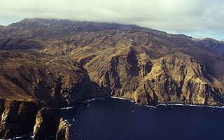
Fogo is an island in the Sotavento group of Cape Verde. Its population is 35,837 (2015), with an area of 476 km². It reaches the highest altitude of all the islands in Cape Verde, rising to 2,829 metres above sea level at the summit of its active volcano, Pico do Fogo.

Ribeira Grande, Cape Verde (municipality) Municipality in Santo Antão, Cape Verde

Ribeira Grande is a concelho (municipality) of Cape Verde. Situated in the northern part of the island of Santo Antão, it covers one fifth of the island area, and is home to nearly half of its population. Its seat is the city Ponta do Sol.

Furna (Brava) Settlement in Brava, Cape Verde

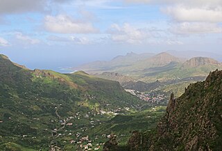
Furna is a seaside community in the northeastern part of the island of Brava, Cape Verde. It lies 2.5 km northeast of the island capital of Nova Sintra. At the 2010 census its population was 612.

Campo Baixo Settlement in Brava, Cape Verde

Campo Baixo is a small settlement located in the southwestern part of the island of Brava, Cape Verde. In English, the name of the village means "low field". It is situated in the mountains, 1.5 km southwest of Nossa Senhora do Monte and 4 km southwest of the island capital Nova Sintra. From Nossa Senhora do Monte, Campo Baixo is accessible by "Aluguer" buses.

Tantum Settlement in Brava, Cape Verde

Tantum or Lomba Tantum is a small settlement located in the southwest corner of the island Brava, Cape Verde. It is one of the southernmost settlements in Cape Verde, together with nearby Cachaço. Its 2010 population was 282. It sits at an elevation of 228 meters. It is situated in the mountains near the south coast, 6 km southwest of the island capital Nova Sintra.

Cachaço Settlement in Brava, Cape Verde

Cachaço is a village on the island of Brava, Cape Verde. It is situated in the mountains, 4 km south of the island capital Nova Sintra. In 2010 its population was 228. Its elevation is 592 meters. Cachaço is the second southernmost settlement in Cape Verde, after nearby Tantum. Some 4 km south is the southernmost point in Cape Verde, Ponta Nhô Martinho.

Santa Bárbara, Cape Verde Settlement in Brava, Cape Verde

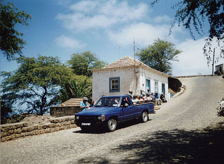
Santa Bárbara is a village in the northeastern part of the island of Brava, Cape Verde. It is situated at 350 m elevation, close to the Atlantic coast. It is about 1 kilometer east of the island capital of Nova Sintra. To its southeast is the small village of Vinagre. Santa Bárbara can be reached by "Aluguer" buses.

Cova Figueira Settlement in Fogo, Cape Verde

Cova Figueira is a city in the southeastern part of the island of Fogo, Cape Verde. In 2010 its population was 1,230, making it the most populated place in the municipality. It is situated 22 km east of the island capital São Filipe. Since 2005, it serves as the seat of Santa Catarina do Fogo Municipality. Its elevation is 480 meters above sea level. The volcano Pico do Fogo is 7.7 km to the northwest. Nearby places include Figueira Pavão in the southwest, Mãe Joana and Estância Roque in the west and Tinteira in the north. Cova Figueira was elevated to a city in 2010.

The Brava Island League is a regional championship played in Brava Island, Cape Verde. The championships are organized by Brava Regional Football Association. The winner of the championship plays in the Cape Verdean football Championships of each season.

São João Baptista (Brava) Civil parish in Brava, Cape Verde

São João Baptista is a freguesia of Cape Verde. It covers the eastern part of the island of Brava. The parish seat is Nova Sintra. To its west is the parish of Nossa Senhora do Monte.

Nossa Senhora do Monte (Brava) Civil parish in Brava, Cape Verde

Nossa Senhora do Monte is a freguesia of Cape Verde. It covers the western part of the island of Brava. To its east is the parish of São João Baptista.

Cova Rodela Settlement in Brava, Cape Verde

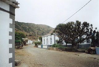
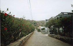
Cova Rodela is a village in the middle of the island of Brava, Cape Verde. The village is situated in the mountains, 1 km west of the island capital Nova Sintra. There are good walking paths to the island's tallest mountain Monte Fontainhas. Most of the inhabitants of the village live on agriculture, growing maize and bananas. In the main street there is a noteworthy old dragon tree. Cova Rodela can be reached easily by aluguer buses from Nova Sintra and from other villages on Brava.

Talho Settlement in São Nicolau, Cape Verde

Talho is a settlement in the central part of the island of São Nicolau, Cape Verde. It is located in the valley of Ribeira Brava, 1 km west of the city Ribeira Brava. In 2010 its population was 308. It is part of the municipality of Ribeira Brava and the parish of Nossa Senhora do Rosário.

Vinagre, Cape Verde Settlement in Brava, Cape Verde

Vinagre is a village in the eastern part of the island of Brava, Cape Verde. It is situated at 200 m elevation, close to the Atlantic coast. It is about 3 kilometer east of the island capital of Nova Sintra, northwest is the small village of Santa Bárbara.

References

  1. "2010 Census results". Instituto Nacional de Estatística Cabo Verde (in Portuguese). 24 November 2016.
  2. 1 2 Reitmeier, Pitt: Cabo Verde, p. 415-6. Bielefeld 2009.