Related Research Articles
Most transportation in Cape Verde is done by air. There are regular flights between the major islands, with less frequent flights to the other islands. Boat transportation is available, though not widely used nor dependable. In the major cities, public bus transport runs periodically and taxis are common. In smaller towns, there are mostly hiaces and/or taxis.

The recorded history of Cape Verde begins with Portuguese discovery in 1456. Possible early references go back around 2000 years.

Sal is an island in Cape Verde. Sal is a tourist destination with white sandy beaches and over 350 days of sunshine a year. It is one of the three sandy eastern islands of the Cape Verde archipelago in the central Atlantic Ocean, 350 mi (560 km) off the west coast of Africa. Cabo Verde is known for year-round kiteboarding, for the large reserve of Caretta turtles which hatch from July to September, and the music of Cesaria Evora.
Cabo Verde Airlines is an international airline based in Cape Verde. It connects three continents with non-stop flights from their hub at Amílcar Cabral International Airport on Sal Island.

Boa Vista, also written as Boavista, is a desert-like island that belongs to the Cape Verde Islands. At 631.1 km2 (243.7 sq mi), it is the third largest island of the Cape Verde archipelago.

Santiago is the largest island of Cape Verde, its most important agricultural centre and home to half the nation's population. Part of the Sotavento Islands, it lies between the islands of Maio and Fogo. It was the first of the islands to be settled: the town of Ribeira Grande was founded in 1462. Santiago is home to the nation's capital city of Praia.

Espargos is the capital and main commercial centre of the island and municipality of Sal, Cape Verde. The city is situated in the heart of the island.
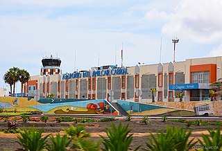
Amílcar Cabral International Airport, also known as Sal International Airport, is the main international airport of Cape Verde. The airport is named after the revolutionary leader Amílcar Cabral. It is located two km west-southwest from Espargos on Sal Island. Sal is the main hub for the national airline, Cabo Verde Airlines; and serves as a base for carrier Cabo Verde Express. This airport was also one of NASA's locations for a facility to handle the Space Shuttle after reentering from orbit.

Nelson Mandela International Airport, also known as Praia International Airport, is the airport of Santiago Island in Cape Verde. It was opened in October 2005, replacing the old Francisco Mendes International Airport. It is located about 3 km northeast of the city centre of Praia in the southeastern part of the island of Santiago.

Halcyonair, S.A. was an airline with its head office in Amílcar Cabral International Airport in Espargos, Sal, Cape Verde. It was established in April 2005 and operated domestic flights between the Cape Verde Islands from its main base Amílcar Cabral International Airport.

Cesária Évora Airport is Cape Verde's fourth-busiest airport, located on the island of São Vicente, nearly 5 kilometres (3.1 mi) from the centre of Mindelo. It is located in the valley area in the west of the island and is north of the village of São Pedro. Its runway is 2,000 metres (6,600 ft) long and its width is 45 metres (148 ft)

Aristides Pereira International Airport is an airport in Cape Verde located on the island of Boa Vista, about 5 km southeast of the island capital Sal Rei. It is the third-busiest airport in the country.

Health in Cape Verde is limited due to limited health care in Cape Verde. Gains since 2000 have led to improvements.
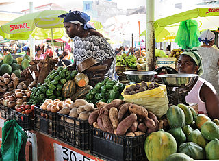
The economy of Cape Verde is a service-oriented economy that is focused on commerce, trade, transport and public services. Cape Verde is a small archipelagic nation that lacks resources and has experienced severe droughts. Agriculture is made difficult by lack of rain and is restricted to only four islands for most of the year. Cape Verde's economy has been steadily growing since the late 1990s, and it is now officially considered a country of average development, being only the second African country to have achieved such transition, after Botswana in 1994. Cape Verde has significant cooperation with Portugal at every level of the economy, which has led it to link its currency first to the Portuguese escudo and, in 1999, to the euro.
Cape Verde or Cabo Verde, officially the Republic of Cabo Verde, is an archipelago and island country in the central Atlantic Ocean, consisting of ten volcanic islands with a combined land area of about 4,033 square kilometres (1,557 sq mi). These islands lie between 600 to 850 kilometres west of Cap-Vert, the westernmost point of continental Africa. The Cape Verde islands form part of the Macaronesia ecoregion, along with the Azores, the Canary Islands, Madeira, and the Savage Isles.
Cape Verde has risen to prominence in a number of sporting areas in recent decades.
Aeroportos e Segurança Aérea is the operator of airports of Cape Verde. Its headquarter is in Espargos on the island of Sal. It was founded as a state company on February 17, 1984, and was privatised to a Sociedade Anónima in 2001. With 530 employees (2017), it manages the four international and three domestic airports of Cape Verde. It also manages air traffic in the flight information region of Sal.
The Architecture of Cape Verde has different architectural styles in the nation. Unlike the African mainland, Cape Verde was uninhabited until 1461 when the Portuguese arrived, most of the other islands were first inhabited after the end of the 15th century. Its architecture was introduced in the 1460s and has its first origins from Portuguese settlers from the Madeira Islands, after the first arrival of mainland Africans, a bit of African architecture would be elements mainly in rural areas. The Manueline was its first architectural style on the island, it was later followed by Renaissance, Baroque, Pombaline, Early Modern and Modern. It was one of the last in the whole of Africa to introduce architecture late. Cape Verde has one of the richest architecture in the western portion of West Africa, the sub-Saharan portion, the richest probably being Mali.

The island of Sal in Cape Verde in the east of the Barlavento Islands is home to several teams and clubs. The major professional club may now be Académico do Aeroporto do Sal, the remaining clubs are amateur or beginners. In 1976, Sal would have its own island championships of each sport. The football competition was the third along with Fogo to have its own first held in 1976 after the nation's independence. Since 2014, the football (soccer) was the only competition divided into two divisions.
References
- 1 2 Great Circle Mapper: Airports in Cape Verde
- ↑ "Boletim Estatístico de Tráfego – Ano 2017" (PDF) (in Portuguese). ASA. January 2018. Retrieved 17 October 2018.
{{cite web}}: CS1 maint: url-status (link)