Continent | Africa |
---|---|
Region | Atlantic Ocean |
Coordinates | 16°N24°W / 16°N 24°W |
Area | Ranked 165th |
• Total | 4,033 km2 (1,557 sq mi) |
• Land | 100% |
• Water | 0% |
Coastline | 965 km (600 mi) |
Borders | None |
Highest point | Mount Fogo 2,829 metres (9,281 ft) |
Lowest point | Atlantic Ocean 0 metres (0 ft) |
Exclusive economic zone | 800,561 km2 (309,098 sq mi) |
Cape Verde (formally, the Republic of Cabo Verde) is a group of arid Atlantic islands which are home to distinct communities of plants, birds, and reptiles. The islands constitute the unique Cape Verde Islands dry forests ecoregion, according to the World Wildlife Fund.
The Cape Verde Islands are located in the mid-Atlantic Ocean some 450 km (280 mi) off the west coast of the continent of Africa. [1] The landscape varies from dry plains to high active volcanoes with cliffs rising steeply from the ocean. The climate is arid. The total size is 4,033 km2 (1,557 sq mi).
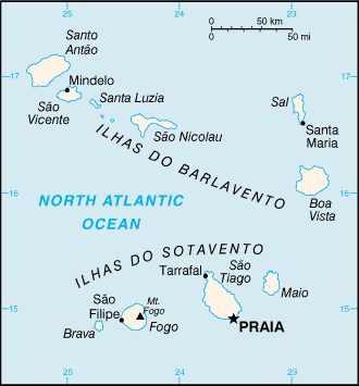
The archipelago consists of ten islands and five islets, divided into the windward (Barlavento) and leeward (Sotavento) groups. [1] The six islands in the Barlavento group are Santo Antão, São Vicente, Santa Luzia, São Nicolau, Sal, and Boa Vista. [1] The islands in the Sotavento group are Maio, Santiago, Fogo, and Brava. [1] All but Santa Luzia are inhabited. [1]
Three islands – Sal, Boa Vista, and Maio – generally are level and lack natural water supplies. [1] Mountains higher than 1,280 metres (4,199 ft) are found on Santiago, Fogo, Santo Antão, and São Nicolau. [1]
Sand carried by strong winds has caused erosion on all islands, especially the windward ones. [1] Sheer, jagged cliffs rise from the sea on several of the mountainous islands. [1] The lack of natural vegetation in the uplands and coast [1] also contributes to soil erosion. [2] The interior valleys support denser natural vegetation. [1]
Island or islet | Largest Settlement | Other Settlements | Area (km2) | Population |
---|---|---|---|---|
Barlavento Islands | 2265.55 | 179114 | ||
Santo Antão | Porto Novo | Ribeira Grande, Pombas, Ponta do Sol | 779.0 | 46872 |
São Vicente | Mindelo | 227.0 | 81267 | |
Ilhéu dos Pássaros | uninhabited | 0.05 | 0 | |
Santa Luzia | uninhabited | 34.0 | 0 | |
Ilhéu Raso | uninhabited | 7.0 | 0 | |
Ilhéu Branco | uninhabited | 3.0 | 0 | |
São Nicolau | Ribeira Brava | Tarrafal de São Nicolau | 379.5 | 13680 |
Sal | Espargos | Santa Maria | 216.0 | 27515 |
Boa Vista | Sal Rei | Estância de Baixo | 620.0 | 9779 |
Sotavento Islands | 1806.95 | 345886 | ||
Maio | Vila do Maio | Calheta | 269.0 | 7420 |
Santiago | Praia | Assomada, Tarrafal, Calheta de São Miguel, Pedra Badejo, Cidade Velha | 991.0 | 292500 |
Fogo | São Filipe | Mosteiros, Cova Figueira | 475.6 | 39567 |
Brava | Nova Sintra | Furna | 66.6 | 6399 |
Ilhéus Secos | uninhabited | 4.75 | 0 | |
Cabo Verde shares maritime boundaries with Mauritania and Senegal. Cabo Verde has signed treaties with Senegal and Mauritania delimiting the specific boundaries. However, the two treaties conflict in their delimitation of the precise borders. Due to the numerous islands it has an Exclusive Economic Zone of 800,561 km2 (309,098 sq mi).
Sal Island | ||||||||||||||||||||||||||||||||||||||||||||||||||||||||||||
---|---|---|---|---|---|---|---|---|---|---|---|---|---|---|---|---|---|---|---|---|---|---|---|---|---|---|---|---|---|---|---|---|---|---|---|---|---|---|---|---|---|---|---|---|---|---|---|---|---|---|---|---|---|---|---|---|---|---|---|---|
Climate chart (explanation) | ||||||||||||||||||||||||||||||||||||||||||||||||||||||||||||
| ||||||||||||||||||||||||||||||||||||||||||||||||||||||||||||
|
Rainfall is irregular, historically causing periodic droughts and famines. [1] Desalination plants now provide water to more than half the country's population. [6] [7] Experiments with fog collectors have been conducted since 1962, [8] however, such collectors had not been expanded beyond the Serra Malagueta community of Santiago Island, as of 2009. [9] The average precipitation per year in Praia is 240 mm (9.45 in). [1]
During the winter, storms blowing from the Sahara sometimes cloud the sky; however, sunny days are the norm year round. [1] The clearest skies are found between February and June, with very little rainfall during these months. Saharan dust, Harmattan wind, laden with dust come from the Sahara. This occurs between November and March and is generally similar to the "Calima" affecting the Canary Islands.
The ocean near Cabo Verde is an area of tropical cyclone formation; since these storms have the whole Atlantic over which to develop as they move westward, they are among the most intense hurricanes, and are called Cape Verde-type hurricanes.
The Cape Verde islands are a very degradated area. Also, most islands do not always get a monsoon. In fact, it is not surprising that some atmospheric precipitation of islands are limited in tropical rain.
If rain arrives, it is usually between August and October. The first "rainy season" brings high temperatures and high humidity that condenses as dew mountain. The other rainy season is between December and June, when the northeast trade winds are common during this season, only altitudes above 600 m tend to receive regular rain. The island of Sal receives an average of 0 mm in May. When the rain comes, if it comes, it can be very strong. Half of the rain in a particular year can often fall into a single storm. Most of the Cape Verde islands are dry, but on islands with high mountains and farther away from the continental land mass, by orography, the humidity is much higher, giving a rainforest habitat, very degraded by the strong human presence. Northeastern slopes of high mountains often receive a lot of rain and southwestern slopes do not. This is because they are umbria areas, situated in the north hillsides or slopes of the mountainous areas, oriented behind the Sun in the Northern Hemisphere, in the shadyside orographic. So the amount of solar radiation that it receive is much lower than it would if it had without the island's relief which intercepts much of the sunlight. In terms of botanical ecology, these umbria areas are identified as being cool and moist.
The current north of the Canaries, has a cooling effect on the islands of Cabo Verde, making the air temperature more bearable than it would expect in any case at this latitude. Conversely, the islands do not receive the upwellings (cold streams) that affect the West African coast, so the air temperature is cooler than in Senegal, but the sea is actually warmer, because the orographic relief of some islands, such as Sao Miguel with steep mountains, cover it with rich woods and luxuriant vegetation where the humid air condenses and soak the plants, rocks, soil, logs, and moss.
Hurricanes often begin forming in the waters around the islands of Cabo Verde, but it is rare that the strength of the storm reaches close to the islands. A Cape Verde type hurricane is formed in the area south of the islands, near Sao Miguel, after a tropical wave on the African continent during the rainy season. The storm picks up strength when it crosses the warm waters of Atlantic.
The laurel forest is a type of cloud forest, the cloud forests, are developed preferably about mountains, where the dense moisture from the sea or ocean, is precipitated by the action of the relief. Opposing the terrain to a front of warm, moist air mass, it forces to increase the height above sea level of that body wet and warm air mass, which cools and decreases the dew point, causing it to condense part of the moisture that falls as rain or fog, creating a habitat especially cool, saturated with moisture in the air and soil.
It is the balance between the dry and warm influence of the subtropical anticyclone, hot and dry summer and orography the responsible for carrying cool wet air. As latitude increases, this increases the impact of the storms, which in its journey from west to east, swept the western coasts of continents, dumping heavy rains as carrying high humidity. Precipitation multiply if these air masses are crossing mountains in the way. The resulting climate is wetter, but with an annual oscillation of the temperature moderated by the proximity of the ocean. Appear mostly occupying favorable areas named geographically Umbrias, this is north hillsides or slopes of the mountainous areas that are oriented behind the sun, because the islands are in the Northern Hemisphere, between 600 and 1,500 meters, thus benefiting from the humidity provided by the trade winds to form such a sea of clouds. In its botanical ecology, the mountain umbria is identified with cool and moisture.
Climate data for Praia (Nelson Mandela International Airport) 1981–2010 | |||||||||||||
---|---|---|---|---|---|---|---|---|---|---|---|---|---|
Month | Jan | Feb | Mar | Apr | May | Jun | Jul | Aug | Sep | Oct | Nov | Dec | Year |
Record high °C (°F) | 31.9 (89.4) | 33.1 (91.6) | 34.2 (93.6) | 33.4 (92.1) | 33.3 (91.9) | 34.1 (93.4) | 32.5 (90.5) | 33.1 (91.6) | 36.2 (97.2) | 34.8 (94.6) | 33.0 (91.4) | 31.0 (87.8) | 36.2 (97.2) |
Mean daily maximum °C (°F) | 26.5 (79.7) | 27.0 (80.6) | 28.1 (82.6) | 28.2 (82.8) | 28.9 (84.0) | 29.6 (85.3) | 29.6 (85.3) | 30.4 (86.7) | 30.9 (87.6) | 31.0 (87.8) | 29.7 (85.5) | 27.7 (81.9) | 29.0 (84.2) |
Daily mean °C (°F) | 22.9 (73.2) | 22.9 (73.2) | 23.6 (74.5) | 23.9 (75.0) | 24.7 (76.5) | 25.5 (77.9) | 26.1 (79.0) | 27.1 (80.8) | 27.4 (81.3) | 27.2 (81.0) | 26.1 (79.0) | 24.1 (75.4) | 25.1 (77.2) |
Mean daily minimum °C (°F) | 19.3 (66.7) | 19.2 (66.6) | 19.5 (67.1) | 19.9 (67.8) | 20.7 (69.3) | 21.6 (70.9) | 22.7 (72.9) | 23.9 (75.0) | 24.2 (75.6) | 23.6 (74.5) | 22.5 (72.5) | 20.8 (69.4) | 21.5 (70.7) |
Record low °C (°F) | 16.9 (62.4) | 16.2 (61.2) | 16.5 (61.7) | 17.0 (62.6) | 18.8 (65.8) | 19.2 (66.6) | 20.3 (68.5) | 20.6 (69.1) | 19.6 (67.3) | 19.6 (67.3) | 19.5 (67.1) | 17.3 (63.1) | 16.2 (61.2) |
Average precipitation mm (inches) | 3.1 (0.12) | 0.6 (0.02) | 0.3 (0.01) | 0.0 (0.0) | 0.5 (0.02) | 0.0 (0.0) | 8.0 (0.31) | 60.4 (2.38) | 60.9 (2.40) | 31.0 (1.22) | 2.7 (0.11) | 5.0 (0.20) | 172.5 (6.79) |
Average precipitation days (≥ 0.1 mm) | 1 | 0 | 0 | 0 | 0 | 0 | 2 | 7 | 7 | 4 | 2 | 1 | 24 |
Average relative humidity (%) | 65.7 | 63.3 | 62.6 | 64.5 | 65.2 | 68.5 | 73.3 | 76.0 | 76.8 | 72.9 | 69.8 | 70.1 | 69.1 |
Mean monthly sunshine hours | 223.2 | 234.5 | 279.0 | 285.0 | 306.9 | 279.0 | 217.0 | 201.5 | 216.0 | 244.9 | 234.0 | 204.6 | 2,925.6 |
Mean daily sunshine hours | 7.2 | 8.3 | 9.0 | 9.5 | 9.9 | 9.3 | 7.0 | 6.5 | 7.2 | 7.9 | 7.8 | 6.6 | 8.0 |
Source 1: Instituto Nacional de Meteorologia e Geofísica [10] | |||||||||||||
Source 2: Deutscher Wetterdienst (extremes, precipitation days, and sun) [11] |
Climate data for Sal, Cape Verde (Amílcar Cabral International Airport) 1981–2010, extremes 1950–1990 | |||||||||||||
---|---|---|---|---|---|---|---|---|---|---|---|---|---|
Month | Jan | Feb | Mar | Apr | May | Jun | Jul | Aug | Sep | Oct | Nov | Dec | Year |
Record high °C (°F) | 32 (90) | 30 (86) | 33 (91) | 33 (91) | 33 (91) | 34 (93) | 33 (91) | 33 (91) | 38 (100) | 34 (93) | 33 (91) | 30 (86) | 38 (100) |
Mean daily maximum °C (°F) | 24.8 (76.6) | 25.0 (77.0) | 25.3 (77.5) | 25.6 (78.1) | 26.1 (79.0) | 27.0 (80.6) | 27.9 (82.2) | 29.5 (85.1) | 30.1 (86.2) | 29.5 (85.1) | 28.1 (82.6) | 26.1 (79.0) | 27.1 (80.8) |
Daily mean °C (°F) | 21.5 (70.7) | 21.2 (70.2) | 21.5 (70.7) | 22.0 (71.6) | 22.6 (72.7) | 23.6 (74.5) | 24.8 (76.6) | 26.2 (79.2) | 26.8 (80.2) | 26.1 (79.0) | 24.6 (76.3) | 22.8 (73.0) | 23.6 (74.5) |
Mean daily minimum °C (°F) | 18.9 (66.0) | 18.5 (65.3) | 18.7 (65.7) | 19.3 (66.7) | 20.2 (68.4) | 21.3 (70.3) | 22.5 (72.5) | 23.8 (74.8) | 24.4 (75.9) | 23.6 (74.5) | 22.0 (71.6) | 20.3 (68.5) | 21.1 (70.0) |
Record low °C (°F) | 12 (54) | 10 (50) | 12 (54) | 15 (59) | 15 (59) | 15 (59) | 17 (63) | 20 (68) | 20 (68) | 19 (66) | 17 (63) | 16 (61) | 10 (50) |
Average precipitation mm (inches) | 6.7 (0.26) | 2.3 (0.09) | 1.3 (0.05) | 0.7 (0.03) | 0.5 (0.02) | 0.0 (0.0) | 1.2 (0.05) | 13.9 (0.55) | 28.1 (1.11) | 11.0 (0.43) | 2.1 (0.08) | 3.4 (0.13) | 71.2 (2.8) |
Average precipitation days (≥ 0.1 mm) | 1 | 1 | 0 | 0 | 0 | 0 | 0 | 2 | 3 | 1 | 1 | 0 | 10 |
Average relative humidity (%) | 69.0 | 70.9 | 70.9 | 70.6 | 73.3 | 75.4 | 75.5 | 75.9 | 77.1 | 74.7 | 72.9 | 71.1 | 73.1 |
Mean monthly sunshine hours | 182.9 | 175.2 | 201.5 | 216.0 | 204.6 | 174.0 | 148.8 | 161.2 | 180.0 | 198.4 | 189.0 | 155.0 | 2,186.6 |
Mean daily sunshine hours | 5.9 | 6.2 | 6.5 | 7.2 | 6.6 | 5.8 | 4.8 | 5.2 | 6.0 | 6.4 | 6.3 | 5.0 | 6.0 |
Source 1: Instituto Nacional de Meteorologia e Geofísica [10] | |||||||||||||
Source 2: Deutscher Wetterdienst (extremes, precipitation days, and sun) [12] |
Climate data for Mindelo (1981–2010) | |||||||||||||
---|---|---|---|---|---|---|---|---|---|---|---|---|---|
Month | Jan | Feb | Mar | Apr | May | Jun | Jul | Aug | Sep | Oct | Nov | Dec | Year |
Record high °C (°F) | 29.2 (84.6) | 29.5 (85.1) | 30.3 (86.5) | 29.5 (85.1) | 31.5 (88.7) | 30.5 (86.9) | 33.6 (92.5) | 31.8 (89.2) | 32.7 (90.9) | 31.5 (88.7) | 31.0 (87.8) | 30.0 (86.0) | 33.6 (92.5) |
Mean daily maximum °C (°F) | 23.4 (74.1) | 23.2 (73.8) | 23.9 (75.0) | 24.0 (75.2) | 24.9 (76.8) | 25.4 (77.7) | 27.1 (80.8) | 28.3 (82.9) | 28.8 (83.8) | 28.0 (82.4) | 26.8 (80.2) | 25.2 (77.4) | 25.7 (78.3) |
Daily mean °C (°F) | 21.9 (71.4) | 21.6 (70.9) | 22.0 (71.6) | 22.2 (72.0) | 22.8 (73.0) | 23.8 (74.8) | 25.0 (77.0) | 26.2 (79.2) | 26.5 (79.7) | 26.0 (78.8) | 25.0 (77.0) | 23.3 (73.9) | 23.9 (75.0) |
Mean daily minimum °C (°F) | 19.9 (67.8) | 19.7 (67.5) | 19.6 (67.3) | 20.2 (68.4) | 20.9 (69.6) | 21.9 (71.4) | 22.9 (73.2) | 24.1 (75.4) | 24.8 (76.6) | 24.2 (75.6) | 23.2 (73.8) | 21.7 (71.1) | 21.9 (71.4) |
Record low °C (°F) | 16.5 (61.7) | 13.5 (56.3) | 15.6 (60.1) | 15.0 (59.0) | 15.0 (59.0) | 18.0 (64.4) | 17.5 (63.5) | 14.5 (58.1) | 19.0 (66.2) | 18.5 (65.3) | 19.0 (66.2) | 17.0 (62.6) | 13.5 (56.3) |
Average precipitation mm (inches) | 4.8 (0.19) | 1.7 (0.07) | 0.4 (0.02) | 0.4 (0.02) | 0.0 (0.0) | 0.0 (0.0) | 2.6 (0.10) | 16.3 (0.64) | 36.2 (1.43) | 14.5 (0.57) | 6.3 (0.25) | 1.0 (0.04) | 84.2 (3.33) |
Average precipitation days (≥ 0.1 mm) | 1 | 1 | 0 | 0 | 0 | 0 | 1 | 4 | 5 | 2 | 2 | 2 | 18 |
Average relative humidity (%) | 66.1 | 67.6 | 67.2 | 68.2 | 70.1 | 72.9 | 72.7 | 74.0 | 74.2 | 72.8 | 69.4 | 67.3 | 70.2 |
Mean monthly sunshine hours | 229.4 | 237.3 | 275.9 | 291.0 | 306.9 | 276.0 | 248.0 | 226.3 | 225.0 | 238.7 | 225.0 | 201.5 | 2,981 |
Mean daily sunshine hours | 7.4 | 8.4 | 8.9 | 9.7 | 9.9 | 9.2 | 8.0 | 7.3 | 7.5 | 7.7 | 7.5 | 6.5 | 8.2 |
Source 1: Instituto Nacional de Meteorologia e Geofísica [10] | |||||||||||||
Source 2: Deutscher Wetterdienst (extremes, precipitation days, and sun) [13] |
Cape Verde is the driest archipelago of the ecoregion of Macaronesia. That with a greater influence of African species due to its geographical location near the African mainland of the Sahel. At first, the islands of Cabo Verde housed an extensive savanna and dry forest cover, but mostly it was removed to convert to agricultural land, which, together with the arid climate and rugged terrain, has led to a soil erosion and desertification widespread. However, the archipelago can be divided into four broad ecological zones (arid, semiarid, subhumid and humid), according to altitude and average annual rainfall ranging from 200 mm in the arid areas of the coast to more than 1000 mm in the humid mountain. Mostly rainfall precipitation is due to condensation of the ocean mist. Today much of the forest cover comprises relatively immature agroforestry plantations, in which are used non-native species such as Prosopis juliflora, Leucaena leucocephala and Jatropha curcas. The native laurel forest species are in wet area only in mountainous areas.
On the lower and drier islands the vegetation, before human colonization, consisted of savanna or steppe vegetation, with the flattest inland portion supporting semi-desert plants. At higher altitudes, a form of arid shrubland was also present. These islands were covered with savanna on the plains and arid shrubland on the mountainsides, but after over 500 years of human habitation (after Portuguese colonisation) nearly all the original vegetation has been cleared in favour of widespread agriculture including the grazing of goats, sheep and cattle and the planting of imported crop species. There are some remaining patches of dry forest high on steep mountainside including a number of endemic plant species, but these are inaccessible and hard to study.
On the higher islands and somewhat wetter islands, exclusively in mountainous areas, like Santo Antao island, the climate is suitable for the development of dry monsoon forest, and laurel forest as this vegetation is believed to have been present in the past. However, most vegetation has now been converted to agriculture and forest fragments are now restricted to areas where cultivation is not possible, such as mountain peaks and steep slopes. The demand for wood has resulted in deforestation and desertification.
Of particular note is the endemic type of humid subtropical laurel forest of macaronesian laurisilva, found on several of the Macaronesian African mainland enclaves and Macaronesian islands of the North Atlantic, namely Madeira Islands, the Azores, Cape Verde Islands, and the Canary Islands; these are a relic of the Pliocene subtropical forests, supporting numerous endemic species.
This laurisilva forests are found in the islands of Macaronesia in the eastern Atlantic, in particular the Azores, Madeira Islands, and western Canary Islands, from 400 m to 1,200 m elevation. Trees of the genera Apollonias (Lauraceae), Ocotea (Lauraceae), Persea (Lauraceae), Clethra (Clethraceae), Dracaena (Ruscaceae), and Picconia (Oleaceae) are characteristic. [14] The Madeira Islands laurel forest was designated a World Heritage Site by UNESCO in 1999.
There are four endemic bird species including the Raso lark along with more common swifts, larks, warblers, and sparrows. The islands are an important breeding site for seabirds including the Cape Verde shearwater and Fea's petrel (Pterodroma feae), which breeds only here and in Madeira. Santiago Island holds the only breeding site of the endemic and critically endangered Bourne's heron. The 11 endemic reptile species include a giant gecko ( Tarentola gigas), and there are other geckos and skinks in abundance. The giant skink ( Macroscincus coctei ) is now thought to be extinct.
Almost all of the natural environment has been destroyed by conversion to agriculture and logging for firewood, as well as natural soil erosion, all of which has threatened several species of birds and reptiles. The remaining original forest exists at high altitudes only. Newer problems include illegal beach sand extraction and overfishing while the nesting birds are vulnerable due to introduced mammals, including cats and rats.
The recorded history of Cape Verde begins with the Portuguese discovery of the island in 1458. Possible early references to Cape Verde date back at least 2,000 years.
Macaronesia is a collection of four volcanic archipelagos in the North Atlantic Ocean, off the coast of North Africa and Europe. Each archipelago is made up of a number of Atlantic oceanic islands, which are formed by seamounts on the ocean floor whose peaks have risen above the ocean's surface.
Fogo is an island in the Sotavento group of Cape Verde in the central Atlantic Ocean. Its population is 35,837 (2015), with an area of 476 km2. It reaches the highest altitude of all the islands in Cape Verde, rising to 2,829 metres above sea level at the summit of its active volcano, Pico do Fogo.
Brava is an island in Cape Verde, and is part of the Sotavento group, in the central Atlantic Ocean. At 62.5 km2 (24.1 sq mi), it is the smallest inhabited island of the Cape Verde archipelago, but at the same time the greenest. First settled in the early 16th century, its population grew after Mount Fogo on neighbouring Fogo erupted in 1680. For more than a century, its main industry was whaling, but the island economy is now primarily agricultural.
Sal is an island in Cape Verde. Sal is a tourist destination with white sandy beaches and over 350 days of sunshine a year. It is one of the three sandy eastern islands of the Cape Verde archipelago in the central Atlantic Ocean, 350 mi (560 km) off the west coast of Africa. Cabo Verde is known for year-round kiteboarding, for the large reserve of Caretta turtles which hatch from July to September, and the music of Cesaria Evora.
Santo Antão is the northwesternmost island of Cape Verde. At 785 km2 (303 sq mi), it is the largest of the Barlavento Islands group, and the second largest island of Cape Verde. The nearest island is São Vicente to the southeast, separated by the sea channel Canal de São Vicente. Its population was 38,200 in mid 2019, making it the fourth most populous island of Cape Verde after Santiago, São Vicente and Sal. Its largest city is Porto Novo located on the southern coast.
Boa Vista, sometimes incorrectly spelled Boavista, is a desert-like island that belongs to the Cape Verde Islands. At 631.1 km2 (243.7 sq mi), it is the third largest island of the Cape Verde archipelago.
Santiago is the largest island of Cape Verde, its most important agricultural centre and home to half the nation's population. Part of the Sotavento Islands, it lies between the islands of Maio and Fogo. It was the first of the islands to be settled: the town of Ribeira Grande was founded in 1462. Santiago is home to the nation's capital city of Praia.
São Filipe is a city on the west coast of the island of Fogo, Cape Verde. It is the capital of the island, and the seat of the São Filipe Municipality. The island's airport, São Filipe Airport, is located on the southeastern edge of the town and the island's port is 4 km north of the center at Vale de Cavaleiros. The town's elevation is 20 meters.
The Cape Verde Islands dry forests is a tropical and subtropical dry broadleaf forests ecoregion in the Cape Verde Islands, which constitute the country of Cabo Verde. The islands lie off the western coast of Africa.
Ribeira Grande is a concelho (municipality) of Cape Verde. Situated in the northern part of the island of Santo Antão, it covers one fifth of the island area (166.5 km2), and is home to nearly half of its population. Its seat is the city Ponta do Sol.
Monte Verde is a mountain in the eastern part of the island of São Vicente, Cape Verde. At 744 m elevation, it is the island's highest point. The mountain is located 6 km (4 mi) east of the city centre of Mindelo.
The wildlife of Cape Verde is found across its archipelago of ten islands and three islets, albeit in smaller numbers of species than mainland Africa. Each volcanic island within the archipelago is unique, and each of them have parks under their jurisdiction, by decree promulgated by the Cape Verde government. Located just off the west coast of Africa, the total land area of the island nation is 4,564 square kilometres (1,762 sq mi).
Porto Novo is a city in the island of Santo Antão, in Cape Verde. It is the seat of the Porto Novo municipality. At the 2010 census, the town had 9,310 inhabitants, which makes it the most populous settlement of the island.
Cape Verde or Cabo Verde, officially the Republic of Cabo Verde, is an archipelago and island country of West Africa in the central Atlantic Ocean, consisting of ten volcanic islands with a combined land area of about 4,033 square kilometres (1,557 sq mi). These islands lie between 600 and 850 kilometres west of Cap-Vert, the westernmost point of continental Africa. The Cape Verde islands form part of the Macaronesia ecoregion, along with the Azores, the Canary Islands, Madeira and the Savage Isles.
Globularia amygdalifolia is a flowering plant of the family Plantaginaceae. The species is endemic to Cape Verde. It is listed as an endangered species by the IUCN.
Moroços Natural Park, in the middle of the island of Santo Antão, is one of ten "natural parks" in Cape Verde. The protected area is 8.18 km2 (3.16 sq mi). It covers 7.46 km2 (2.88 sq mi) of the municipality of Ribeira Grande, and 0.71 km2 (0.27 sq mi) of Porto Novo.
The Flora of Cape Verde includes the flowers and plants of Cape Verde, mostly native to the islands. There are about 240 species of plants.
The Madeira evergreen forests is a laurissilva ecoregion of southwestern Europe. It covers the archipelago of Madeira and some nearby islands in the Atlantic Ocean. Laurel forest, known as Laurisilva of Madeira, once covered the islands. Over centuries the laurel forests were mostly cleared. Madeira's remaining forests are now protected.
{{cite web}}
: CS1 maint: unfit URL (link)