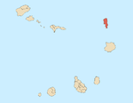
Sal is an island in Cape Verde. Sal is a tourist destination with white sandy beaches and over 350 days of sunshine a year. It is one of the three sandy eastern islands of the Cape Verde archipelago in the central Atlantic Ocean, 350 mi (560 km) off the west coast of Africa. Cabo Verde is known for year-round kiteboarding, for the large reserve of Caretta turtles which hatch from July to September, and the music of Cesaria Evora.

São Nicolau is one of the Barlavento (Windward) islands of Cape Verde. It is located between the islands of Santa Luzia and Sal. Its population is 12,424 (2015), with an area of 343 km2 (132 sq mi). The main towns are Ribeira Brava and Tarrafal de São Nicolau.
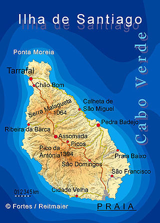
Santiago is the largest island of Cape Verde, its most important agricultural centre and home to half the nation's population. Part of the Sotavento Islands, it lies between the islands of Maio and Fogo. It was the first of the islands to be settled: the town of Ribeira Grande was founded in 1462. Santiago is home to the nation's capital city of Praia.

Paul is a concelho (municipality) of Cape Verde. Situated in the northeastern part of the island of Santo Antão, it covers 7% of the island area, and is home to 16% of its population. Its seat is the town Pombas.

Tarrafal de São Nicolau is a city in the western part of the island of São Nicolau, Cape Verde. With a population of 3,733, it is the most populous settlement of the island. It is the seat of the Tarrafal de São Nicolau Municipality, and the main port of the island. It is situated on the west coast, 9 km southwest of Ribeira Brava.

Santa Maria is a city in the southern part of the island municipality of Sal, Cape Verde. It is located on the south coast, about 16 km south of the Amílcar Cabral International Airport, and 20 km south of the island capital Espargos.

Ponta do Sol is the northernmost city on the island of Santo Antão and Cape Verde. It is situated on the coast, 4 km northwest of Ribeira Grande and 20 km north of the island capital Porto Novo. It is the seat of Ribeira Grande municipality.

Rabil is a town on the island of Boa Vista, Cape Verde. It was the island's former capital. Rabil is the island's second largest town, located 6 kilometres (3.7 mi) southeast of the island capital of Sal Rei. Its population was 1,248 in 2010. The island's airport, Aristides Pereira International Airport, is situated northwest of the town.

Coculi is a town in the northern part of the island of Santo Antão, Cape Verde. It is situated on the river Ribeira Grande, 4 km southwest of the town Ribeira Grande and 17 km north of the island capital Porto Novo. About 400 meters to its west is the confluence of Ribeira de Chã das Pedras.

Palmeira is a town in the northwestern part of the island of Sal, Cape Verde. In 2010 its population was 1,420. The town is situated on the west coast, about 4 km west of the island capital Espargos. Located at Baía de Palmeira, a small bay south of the village, it is home to the main port of the island of Sal. It is the third busiest port of Cape Verde in freight traffic.

Pedra de Lume is a village in the northeastern part of the island of Sal, Cape Verde. The village is situated on the east coast, about 5 km east of the island capital Espargos. It has a small port and a lighthouse, Farol de Pedra de Lume.
São João Baptista is a freguesia of Cape Verde. It covers the larger, southern part of the municipality of Porto Novo, on the island of Santo Antão.
Nossa Senhora do Rosário is a freguesia of Cape Verde. It covers the larger eastern part of the municipality of Ribeira Brava, on the island of São Nicolau.

Pombas is a city in the northeastern part of the island of Santo Antão, Cape Verde. It is the seat of the municipality Paul. It is situated on the coast, at the mouth of the Ribeira do Paul, 7 km (4.3 mi) southeast of Ribeira Grande and 15 km (9.3 mi) north of the island capital Porto Novo. The national roads EN1-SA02 and EN1-SA03 connect Pombas with Ribeira Grande and Porto Novo, respectively. Pombas was elevated from town to city in 2010.

Chã de Igreja is a town in the northern part of the island of Santo Antão, Cape Verde. It is situated near the north coast of the island, in the valley of the river Ribeira da Garça, 19 km northwest of the island capital Porto Novo. In 2010 its population was 672. The nature reserve Cruzinha, which includes the small seaside village Cruzinha da Garça, stretches northeast of Chã de Igreja along the coast.
Preguiça is a settlement in the central part of the island of São Nicolau, Cape Verde. It is situated on the south coast, 6 km south of Ribeira Brava. It served as the port of Ribeira Brava, after the older Porto de Lapa, 6 km to the northeast, had been abandoned in 1653 due to pirate attacks. The settlement was mentioned as Paraghisi in the 1747 map by Jacques-Nicolas Bellin. In 1820 the Forte do Príncipe Real, now ruined, was built to protect the port. Preguiça's port consists of a stone quay and a short mole. Preguiça Airport is located 3 km north of the village.

Ribeira Grande is the largest town of the Ribeira Grande Municipality on the island of Santo Antão, Cape Verde. It has become a city in 2010. In 2010 its population was 2,564. It is situated in the northeastern part of the island, near the outflow of the river Ribeira Grande and its tributary Ribeira da Torre into the Atlantic Ocean. Neighborhoods include Tarrafal, Rua de Agua, Rua d'Horta and Penha de França.

Porto Novo is a city in the island of Santo Antão, in Cape Verde. It is the seat of the Porto Novo municipality. At the 2010 census, the town had 9,310 inhabitants, which makes it the most populous settlement of the island.

Ribeira Brava is a city on the island of São Nicolau, Cape Verde. It is the seat of the Ribeira Brava Municipality. Its population was 1,936 at the 2010 census. The town is situated in the valley of the river Ribeira Brava, east of the main mountain range of the island. The name of the river is Portuguese for "rough stream", referring to the violent behaviour of the river during rains. The city has a colonial look with Portuguese style buildings, parks and gardens, small winding streets, and steep hills.
Chã de Pedras is a settlement in the northcentral part of the island of Santo Antão, Cape Verde. In 2010 its population was 1,266. It is situated about 5 km south of Coculi, 8 km southeast of the city Ribeira Grande and 12 km northwest of the island capital Porto Novo. It consists of 21 localities in the valley of the Ribeira de Chã de Pedras, a right tributary of the Ribeira Grande. The elevation of the largest village, Pia de Cima, is about 430 metres.