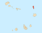
Santa Luzia is an island of the Barlavento archipelago in Cape Verde located between São Nicolau and São Vicente, the channel of Santa Luzia separates the island of São Vicente and is 8 km wide. The area is 34.2 km². Like all Cape Verdean islands, it is of volcanic origin. The highest point is Topona. Santa Luzia is 12.4 km long and 5.3 km wide.
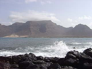
Monte Verde is a mountain in the eastern part of the island of São Vicente, Cape Verde. At 744 m elevation, it is the island's highest point. The mountain is located 6 km (4 mi) east of the city centre of Mindelo.

Monte Penoso is a mountain on the island of Maio, Cape Verde. At 436 m elevation, it is the island highest point. It is situated in the eastern part of the island, 3 km southwest of Pedro Vaz and 13 km northeast of the island capital Porto Inglês. The mountain is of volcanic origin. It is part of the protected landscape Monte Penoso and Monte Branco, which covers 11.17 km2 (4.31 sq mi).

The Cruzinha Nature Reserve is a protected area in the northern part of the island of Santo Antão in the Cape Verde archipelago. It covers part of the north coast of the island, between the rivers Ribeira da Garça and the Ribeira do Mocho. It contains the only coastal dunes of Santo Antão. It takes its name from the village Cruzinha da Garça, part of the town Chã de Igreja.
Serra Negra is a hill in the southeastern part of the island of Sal in Cape Verde. Its maximum elevation is 104 m, the highest point in southern Sal. It stretches for about 2.5 km along the east coast of the island, between the headland Ponta da Fragata in the south and the Ponta do Morrinho Vermelho in the north. The nearest settlement is Murdeira, to the west. The mountain forms part of a protected area as a nature reserve, important as nesting area for seabirds and turtles. The nature reserve covers 3.31 km2 (1.28 sq mi) of land and 22.96 km2 (8.86 sq mi) of ocean.

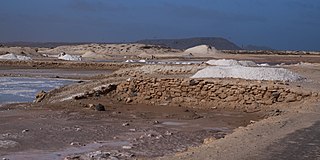
Pedra de Lume is a village in the northeastern part of the island of Sal, Cape Verde. The village is situated on the east coast, about 5 km east of the island capital Espargos. It has a small port and a lighthouse, Farol de Pedra de Lume.

Buracona is a small bay in the northwest of the island of Sal, Cape Verde. The bay is approximately 5 km north of the village Palmeira. The bay is part of the 5.45 km2 (2.10 sq mi) protected landscape of Buracona-Ragona, which covers the coast between Palmeira and Ponta Preta, and the mountain Monte Leste.
Rabo de Junco is a hill on the west coast of the island of Sal in Cape Verde. It is situated at the northern end of the Baía da Murdeira, 8 km southwest of the island capital Espargos. Its steep eroded south face towards the bay is an important nesting area for birds. Rabo de Junco and the surrounding area are protected as a nature reserve. It was mentioned as Rabadyunk in the 1747 map by Jacques-Nicolas Bellin. To its west lies the uninhabited islet Ilhéu Rabo de Junco.
Ponta Preta is a headland in the southwest of the island of Sal in Cape Verde. It is about 2 km west of the town Santa Maria and about 2 km of Ponta do Sinó, the southernmost point of the island. It lies within the nature reserve Ponta do Sinó, at the edge of a tourism development zone.

Ponta do Sol is a headland located in the northwest of the island of Boa Vista. Cape Verde. It is the island's northernmost point. The town Sal Rei is approximately 6 km (3.7 mi) to the south, and the hill Vigia is 2 km (1.2 mi) to the south.
Morro Negro is a hill located near the east coast of the island of Boa Vista, Cape Verde. Its elevation is 156 m. The nearest village is Cabeça dos Tarrafes, 5.5 km to the northwest.

Praia da Varandinha is a beach on the southwest coast of the island of Boa Vista in Cape Verde. It lies north of the headland Ponta Varandinha. The beach forms part of the protected area Morro de Areia Nature Reserve.

Cova-Paul-Ribeira da Torre Natural Park, in the east of the island of Santo Antão, is one of ten "natural parks" in the country of Cape Verde. Its area is 20.92 km2 (8.08 sq mi), of which 8.91 km2 (3.44 sq mi) in the municipality of Ribeira Grande, 8.85 km2 (3.42 sq mi) in the municipality of Paul and 3.16 km2 (1.22 sq mi) in the municipality of Porto Novo. Since 2016, the natural park is on the tentative list of World Heritage sites.
Moroços Natural Park, in the middle of the island of Santo Antão, is one of ten "natural parks" in Cape Verde. The protected area is 8.18 km2 (3.16 sq mi). It covers 7.46 km2 (2.88 sq mi) of the municipality of Ribeira Grande, and 0.71 km2 (0.27 sq mi) of Porto Novo.
Lagoa Cimidor is a small coastal lagoon in the southeastern part of the island of Maio in Cape Verde. It is situated 3.5 km northeast of the village Ribeira Dom João and 13 km east of the island capital Cidade do Maio. It is part of a 3.89 km2 (1.50 sq mi) protected area which also includes the adjacent coast. One of the largest permanent bodies of water on the island, it is an important area for birds and turtles.

Ponta do Sinó is the southernmost point of the island of Sal in Cape Verde. It lies 2 km southwest of Santa Maria city centre. The area north of the headland is a protected area: nature reserve Ponta do Sinó, at the edge of a large tourism development zone. There is a lighthouse on the headland, Farol da Ponta do Sinó, built in 1892.
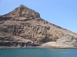
Cagarral is a mountain in the northeastern part of the island of Sal in Cape Verde. It is located near the east coast, 2 km northeast of Pedra de Lume and 6 km east of the island capital Espargos. To its east is the headland Ponta Trás de Cagarral. Together with the mountain and the saltpans to the west, it is a protected area as a protected landscape.

Morro de Areia Nature Reserve is a nature reserve covering the southwestern coast of the island of Boa Vista in Cape Verde. It takes its name from the hill Morro de Areia, 167 m (548 ft) elevation. The natural reserve covers 21.31 km2 of land area, and stretches along the coast from the Praia de Chaves in the north to the Praia de Santa Monica in the south. The reserve includes a 300 m wide marine protection zone, an additional 4.36 km2.

Salinas of the English Port is a saline wetland in the southwestern part of the island of Maio, Cape Verde, northwest of the city Porto Inglês. It is a 5.34 km2 (2.06 sq mi) protected area and a Ramsar site. It encompasses ecological, landscape, historical and cultural values. The site is frequented by species of birds of conservation interest, some of them protected by national laws and international conventions, and some endemic to the archipelago.