Monte Verde is a mountain in the eastern part of the island of São Vicente, Cape Verde. At 744 m elevation, it is the island's highest point. The mountain is located 6 km (4 mi) east of the city centre of Mindelo.

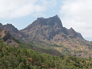
Tope de Coroa is a mountain on the island of Santo Antão's, Cape Verde. At 1,979 m elevation, it is the highest point of the island. It is in the western part of the island, 25 km west of the island capital Porto Novo. The mountain is entirely of volcanic origin. The area is the source of several streams including Ribeira de Monte Trigo which flows westward to Monte Trigo.

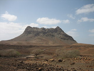
Monte Gordo is a mountain on the island of São Nicolau, Cape Verde. At 1,312 m elevation, it is the island's highest point. It is situated in the western part of the island, 6 km west of the island capital Ribeira Brava. The mountain is of volcanic origin, less than 1 million years old. The boundary of the municipalities Tarrafal de São Nicolau and Ribeira Brava runs over the mountain. It is part of the Monte Gordo Natural Park.

Monte Estância is a mountain in the southeastern part of the island Boa Vista in Cape Verde. At 387 m elevation, it is the island's highest point. It is located 4 km from the Atlantic coast and 23 km southeast of the island capital Sal Rei. It is part of a protected natural space under the statute of natural monument, which covers 739 ha.
Serra Negra is a hill in the southeastern part of the island of Sal in Cape Verde. Its maximum elevation is 104 m, the highest point in southern Sal. It stretches for about 2.5 km along the east coast of the island, between the headland Ponta da Fragata in the south and the Ponta do Morrinho Vermelho in the north. The nearest settlement is Murdeira, to the west. The mountain forms part of a protected area as a nature reserve, important as nesting area for seabirds and turtles. The nature reserve covers 3.31 km2 (1.28 sq mi) of land and 22.96 km2 (8.86 sq mi) of ocean.

Monte Grande is a mountain in the northern part of the island of Sal in Cape Verde. It is situated 8 km northeast of the island capital Espargos. At 406 m elevation, it is the highest point of the island. It is a protected landscape because of its geological value; the protected area covers 1,309 ha. There are pillow lava formations on the coast.

Pedra de Lume is a village in the northeastern part of the island of Sal, Cape Verde. The village is situated on the east coast, about 5 km east of the island capital Espargos. It has a small port and a lighthouse, Farol de Pedra de Lume.

Buracona is a small bay in the northwest of the island of Sal, Cape Verde. The bay is approximately 5 km north of the village Palmeira. The bay is part of the 5.45 km2 (2.10 sq mi) protected landscape of Buracona-Ragona, which covers the coast between Palmeira and Ponta Preta, and the mountain Monte Leste.

Ponta da Fragata is a headland on the east coast of the island of Sal, Cape Verde. It is situated at the southern end of the Serra Negra mountain, 6 km northeast of the town Santa Maria. To the south of the headland stretches the Costa da Fragata, a 4.7 km long sandy beach which is a protected nature reserve, important as nesting area for loggerhead sea turtles. The nature reserve covers 3.46 km2 (1.34 sq mi) of land and 23.47 km2 (9.06 sq mi) of ocean.
Rabo de Junco is a hill on the west coast of the island of Sal in Cape Verde. It is situated at the northern end of the Baía da Murdeira, 8 km southwest of the island capital Espargos. Its steep eroded south face towards the bay is an important nesting area for birds. Rabo de Junco and the surrounding area are protected as a nature reserve. It was mentioned as Rabadyunk in the 1747 map by Jacques-Nicolas Bellin. To its west lies the uninhabited islet Ilhéu Rabo de Junco.
The Serra do Pico de Antónia is a mountain range in the centre of the island of Santiago in the Cape Verde archipelago. It contains the Pico de Antónia, at 1,392 m (4,567 ft) the highest point of the island. It is protected as a natural park,, covering 28.73 km2 (11.09 sq mi). The natural park covers the connected mountain ranges of Serra do Pico de Antónia and of Rui Vaz.
Rocha Estância is a mountain in the southwestern part of the island Boa Vista in Cape Verde, east of the village of Povoação Velha. Its elevation is 357 meters. It is part of a protected area covering 253 ha. The Our Lady of Conception church is located at the western foot of the mountain.

Monte Santo António is a mountain in the southwestern part of the island Boa Vista in Cape Verde. At 379 m (1,243 ft) elevation, it is the island's second highest point. Like Rocha Estância and Monte Estância, it rises steeply from the surrounding plains. It is part of a protected natural area under the statute of natural monument, covering 459 hectares.

Monte Caçador and Pico Forcado Protected Countryside is a protected area covering 3,357 hectares (12.96 sq mi) of land in the eastern part of the island of Boa Vista in Cape Verde. It is the most important mountain formation on the island, but not the highest.
Monte Velha is a peak in the northeastern part of the island of Fogo in Cape Verde. Its elevation is 1,482 m. It is a subpeak of the Pico do Fogo volcano, located at the northeastern end of the crater rim. It lies within the municipality of Mosteiros, 4 km southwest of the city centre. Its forest is a protected area, part of the larger Fogo Natural Park.
Moroços Natural Park, in the middle of the island of Santo Antão, is one of ten "natural parks" in Cape Verde. The protected area is 8.18 km2 (3.16 sq mi). It covers 7.46 km2 (2.88 sq mi) of the municipality of Ribeira Grande, and 0.71 km2 (0.27 sq mi) of Porto Novo.

Morrinho de Açúcar is a small hill in the northern part of the island of Sal in Cape Verde. It is situated 1 km from the north coast and 8 km north of the island capital Espargos. It is a remnant of a volcanic phonolitic chimney, surrounded by a vast plain. It is protected as a natural monument.
Cagarral is a mountain in the northeastern part of the island of Sal in Cape Verde. It is located near the east coast, 2 km northeast of Pedra de Lume and 6 km east of the island capital Espargos. To its east is the headland Ponta Trás de Cagarral. Together with the mountain and the saltpans to the west, it is a protected area as a protected landscape.
Monte Tchota is a mountain located in the central part of Santiago Island in Cape Verde. Its elevation is 1,041 m. It is part of the Serra do Pico de Antónia Natural Park, and lies 1.5 km southeast of Pico de Antónia, the highest point of the island. The village Rui Vaz lies 3 km to the east.