Achada Furna is a settlement in the southern part of the island of Fogo, Cape Verde. It is situated 15 km east of the island capital São Filipe. At the 2010 census its population was 495. Its elevation is about 870 meters. Nearby places include Cabeça Fundão to the north, Figueira Pavão to the east, Fonte Aleixo to the south and Monte Largo to the west.

Lomba is a settlement in the northwestern part of the island of Fogo, Cape Verde. In 2010 its population was 731. It is situated 10 km northeast of the island capital São Filipe.
Figueira Pavão is a settlement in the southeastern part of the island of Fogo, Cape Verde. In 2010 its population was 320. It is situated 3 km southwest of Cova Figueira and 20 km east of the island capital São Filipe. Nearby settlements are Achada Furna to the west and Estância Roque to the north.
Monte Grande is a settlement in the central part of the island of Fogo, Cape Verde. It is situated at about 900 m in elevation, 10 km east of the island capital São Filipe. In 2010 its population was 743. Nearby places include Monte Largo to the southeast, Patim to the southwest and Miguel Gonçalves to the northwest.

Fonte Aleixo is a settlement in the southern part of the island of Fogo, Cape Verde. It is situated 3 km south of Achada Furna and 16 km southeast of the island capital São Filipe. In 2010 its population was 401.
Ribeira do Ilhéu is a settlement in the northern part of the island of Fogo, Cape Verde. It is situated 6 km west of Mosteiros and 20 km northeast of the island capital São Filipe. The nearest village is Atalaia, 1.5 km to the southwest. The village's main festival is the festival of Saint Joseph that takes place on March 19.
Estância Roque is a settlement in the eastern part of the island of Fogo, Cape Verde. In 2010 its population was 411. It is situated 3 km west of Cova Figueira and 19 km east of the island capital São Filipe. Nearby places include Figueira Pavão in the south and Cabeça Fundão in the northwest.
Curral Grande is a settlement in the western part of the island of Fogo, Cape Verde. It is situated 8 km northeast of the island capital São Filipe. In 2010 its population was 398. The village sits at 289 meters above sea level.
Galinheiro is a settlement in the northwestern part of the island of Fogo, Cape Verde. In 2010 its population was 877. It is situated 2 km northeast of Ponta Verde, 2.5 km southwest of São Jorge and 13 km northeast of the island capital São Filipe.

Cabeça Fundão is a settlement in the southern part of the island of Fogo, Cape Verde and sits on the foot of the mountain rim of Bordeira. It is situated 16 km east of the island capital São Filipe. In 2010 its population was 177. The village is located on the road from Achada Furna to Chã das Caldeiras (EN3-FG05). Its elevation is about 1,570 meters. Cabeça Fundão lies directly south of the Fogo Natural Park.
Eito is a village in the northeastern part of the island of Santo Antão, Cape Verde, part of the municipality of Paul. It is situated 1 km southwest of Pombas, 2 km northeast of Figueiral and 15 km northeast of the island capital Porto Novo. Its population was 979 in 2010.

Fontainhas is a settlement in the northern part of the island of Santo Antão, Cape Verde. It is situated near the rocky north coast of the island, 2 km southwest of Ponta do Sol and 19 km north of the island capital Porto Novo. The settlement includes the smaller villages Corvo and Forminguinhas, about 1 km west of Fontainhas proper.

Bofarreira is a village in the northern part of the island of Boa Vista in the Cape Verde archipelago. The village is around 10 km east of the island capital of Sal Rei.

Cabeça dos Tarrafes is a village in the eastern part of the island of Boa Vista, Cape Verde. The village is located about 2 km south of Fundo das Figueiras and 21 km southeast of the island capital of Sal Rei. It is one of the easternmost communities in Cape Verde.

Estância de Baixo is a settlement in the western part of the island of Boa Vista, Cape Verde. Its population was 578 in 2010, making it the island's third most populated place. The village is around 6 km southeast of the island capital of Sal Rei, west of the Deserto de Viana, on the eastern bank of Ribeira do Rabil.

Fundo das Figueiras is a village in the eastern part of the island of Boa Vista. The village is around 21 km east of the island capital of Sal Rei. It is the seat of the civil parish of São João Baptista. 2 km to the south is the village Cabeça dos Tarrafes and 8 km southeast is Ponta Meringuel, the easternmost point in Cape Verde.

João Galego is a village in the northeastern part of the island of Boa Vista, Cape Verde. Its population was 346 at the 2010 census. The village is around 2 km northwest of Fundo das Figueiras and 19 km east of the island capital of Sal Rei.
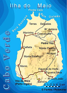
Figueira is a settlement in the southern part of the island of Maio. It consists of the villages Figueira da Horta and Figueira Seca. Figueira is 7 km east of the island capital Porto Inglês. As of the 2010 census, its population was 529. It sits at 40 meters above sea level.
Morro is a settlement in the west of the island of Maio in Cape Verde. It is located 5 km north of the island capital Porto Inglês and 6 km south of Calheta. As of the 2010 census, its population was 310. The beach north of the village, Praia do Morro, is a 6.66 km2 nature reserve.
Bolona is a settlement in the westcentral part of the island of Santo Antão, Cape Verde. In 2010 its population was 112. It is situated about 19 km west of the island capital Porto Novo. At about 1,500 m elevation, it is one of the highest settlements of the island.