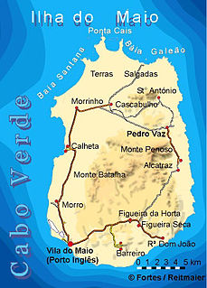
Porto Inglês is a city in the southwestern part of the island of Maio in southeastern Cape Verde. It is the main urban settlement of the island, and also seat of the Maio Municipality. Its population was 2,971 in 2010. The name Porto Inglês refers to English ships that exported salt produced on the island of Maio from this town. Salt exploitation continued until the 19th century. The inconclusive Battle of Maio was fought between British and French frigate squadrons close to the town on 23 January 1814 in the last stages of the Napoleonic Wars.

Achada Furna is a settlement in the southern part of the island of Fogo, Cape Verde. It is situated 15 km east of the island capital São Filipe. At the 2010 census its population was 495. Its elevation is about 870 meters. Nearby places include Cabeça Fundão to the north, Figueira Pavão to the east, Fonte Aleixo to the south and Monte Largo to the west.

Achada Grande is a settlement in the northeastern part of the island of Fogo, Cape Verde. It is situated near the coast, 6 km southeast of Mosteiros. Its population was 538 in 2010. Nearby settlements include Corvo to the north and Relva to the southeast.

Principal is a settlement in the northern part of the island of Santiago, Cape Verde. It is part of the municipality of São Miguel. The settlement consists of several localities along the river Ribeira Principal, including Chão de Horta, Hortelão, Jaqueitão and Mato Curral. In 2010 its population was 1,193. Hortelão is 4 km north of the summit of the Serra Malagueta and 7 km northwest of Calheta de São Miguel.
Figueira Pavão is a settlement in the southeastern part of the island of Fogo, Cape Verde. In 2010 its population was 320. It is situated 3 km southwest of Cova Figueira and 20 km east of the island capital São Filipe. Nearby settlements are Achada Furna to the west and Estância Roque to the north.
Alto Mira is a settlement in the northwestern part of the island of Santo Antão, Cape Verde. It is situated 4 km southeast of Ribeira da Cruz and 18 km northwest of the island capital Porto Novo. Its population was 1,003 at the 2010 census. The Moroços Natural Park lies east of the settlement. The settlement is divided into several localities, including Chã Bonita, Chã Daurinca, Chã de Dragoeiro, Dominguinhas, Faial and Lombo Gorado. The Ribeira Alto Mira flows through the settlement.

Fontainhas is a settlement in the northern part of the island of Santo Antão, Cape Verde. It is situated near the rocky north coast of the island, 2 km southwest of Ponta do Sol and 19 km north of the island capital Porto Novo. The settlement includes the smaller villages Corvo and Forminguinhas, about 1 km west of Fontainhas proper.
Carvoeiros is a settlement in the northern part of the island of São Nicolau, Cape Verde. It is situated on the north coast, 2 km east of Queimadas and 4 km north of Ribeira Brava.
Hortelã is a settlement in the western part of the island of São Nicolau, Cape Verde. In 2010 its population was 181. It is situated at the southern foot of Monte Gordo, 5 km north of Tarrafal de São Nicolau and 6 km west of Ribeira Brava.

Calheta is a town in the western part of the island of Maio. It is situated on the Atlantic coast, around 11 km north of the island capital Porto Inglês and 6 km north of Morro. Its population at the 2010 census was 1,156, making it the island's second most populous settlement. The settlement was mentioned as "Kalyete" in the 1747 map by Jacques-Nicolas Bellin.
Morro is a settlement in the west of the island of Maio in Cape Verde. It is located 5 km north of the island capital Porto Inglês and 6 km south of Calheta. As of the 2010 census, its population was 310. The beach north of the village, Praia do Morro, is a 6.66 km2 nature reserve.
Pedro Vaz is a settlement in the northeast of the island of Maio in Cape Verde. It is located 3.5 km north of Alcatraz and 16 km northeast of the island capital Porto Inglês.
Cascabulho is a village in the northern part of the island of Maio in Cape Verde. In 2010 its population was 204. It is located 15 km northeast of the island capital Porto Inglês. Further north is the nature reserve Terras Salgadas.
Ribeira Prata is a settlement in the northwestern part of the island of São Nicolau, Cape Verde. In 2010 its population was 343. It is situated near the north coast, 3 km northeast of Praia Branca and 11 km north of Tarrafal de São Nicolau.
Lajedo is a settlement in the southcentral part of the island of Santo Antão, Cape Verde. In 2010 its population was 558. It is situated in the valley of Ribeira das Patas, about 11 km west of the island capital Porto Novo. The settlement consists of several localities, including Ponte Sul, Lajedo proper and Vascona. The road from Porto Novo to Ribeira da Cruz in the north of the island passes through Lajedo.
Fragata is a settlement in the northwestern part of the island of São Nicolau, Cape Verde. In 2010 its population was 172. It is situated 2 km south of Ribeira Prata and 9 km north of Tarrafal de São Nicolau. It consists of the localities Cruzinha, Geronimo, Santa Barbara and Fragatona (Tope).

Monte Largo is a settlement in the southern part of the island of Fogo, Cape Verde. It is situated 1.5 km northeast of Salto, 3 km southeast of Monte Grande, 3 km west of Achada Furna and 13 kilometres (8.1 mi) east of the island capital São Filipe. At the 2010 census its population was 274. Its elevation is about 800 meters.

Tinteira is a settlement in the eastern part of the island of Fogo, Cape Verde. It is situated 4 km north of Cova Figueira, 5 km south of Relva and 22 km east of the island capital São Filipe. At the 2010 census its population was 410. Its elevation is 300 meters. Tinteira consists of the localities Tinteira, Cova Matinho and Cutelo Capado.
Luzia Nunes is a settlement in the southwestern part of the island of Fogo, Cape Verde. It is situated 1.5 km west of Patim, 2 km southeast of Vicente Dias and 7 km southeast of the island capital São Filipe. At the 2010 census its population was 438.
Monte Vermelho is a settlement in the southeastern part of the island of Fogo, Cape Verde. It is situated 3 km east of Fonte Aleixo, 3 km southwest of Figueira Pavão, 6 km southwest of Cova Figueira and 19 km southeast of the island capital São Filipe. At the 2010 census its population was 221. Its elevation is about 400 meters.