Lomba is a settlement in the northwestern part of the island of Fogo, Cape Verde. In 2010 its population was 731. It is situated 10 km northeast of the island capital São Filipe.
Lagariça is a settlement in the western part of the island of Fogo, Cape Verde. It is situated 6 km northeast of the island capital São Filipe. One of its localities is named Coxo.
Atalaia is a settlement in the northern part of the island of Fogo, Cape Verde. Its population was 700 in 2010. It is situated near the coast, 6 km west of Mosteiros and 19 km northeast of the island capital São Filipe. The municipal boundary with São Filipe is to the west. Nearby settlements area Ribeira Ilhéu to the east and Campanas Baixo to the west. The festival of Saint John is celebrated every June 24.
Santo António is a settlement in the western part of the island of Fogo, Cape Verde. It is situated 6 km northeast of the island capital São Filipe.
Ribeira do Ilhéu is a settlement in the northern part of the island of Fogo, Cape Verde. It is situated 6 km west of Mosteiros and 20 km northeast of the island capital São Filipe. The nearest village is Atalaia, 1.5 km to the southwest. The village's main festival is the festival of Saint Joseph that takes place on March 19.

Fajãzinha is a settlement in the northern part of the island of Fogo, Cape Verde. It is situated on the coast, 3 km northwest of Mosteiros and 23 km northeast of the island capital São Filipe. Each year on May 13, the festival of Our Lady of Fatima is celebrated in the settlement.
Curral Grande is a settlement in the western part of the island of Fogo, Cape Verde. It is situated 8 km northeast of the island capital São Filipe. In 2010 its population was 398. The village sits at 289 meters above sea level.
Galinheiro is a settlement in the northwestern part of the island of Fogo, Cape Verde. In 2010 its population was 877. It is situated 2 km northeast of Ponta Verde, 2.5 km southwest of São Jorge and 13 km northeast of the island capital São Filipe.
Campanas Baixo is a settlement in the northern part of the island of Fogo, Cape Verde. It is situated 2 km east of São Jorge, 2 km southwest of Atalaia and 16 km northeast of the island capital São Filipe.
Relva is a settlement in the eastern part of the island of Fogo, Cape Verde. It is situated near the coast, 7 km southeast of Mosteiros and 23 km northeast of the island capital São Filipe.
Eito is a village in the northeastern part of the island of Santo Antão, Cape Verde, part of the municipality of Paul. It is situated 1 km southwest of Pombas, 2 km northeast of Figueiral and 15 km northeast of the island capital Porto Novo. Its population was 979 in 2010.

Janela is a settlement in the eastern part of the island of Santo Antão, Cape Verde. It is situated on the Atlantic coast, 4 km southeast of Pombas and 14 km northeast of the island capital Porto Novo The central village, Pontinha, lies on a rocky peninsula. More villages are situated in the valley of the river Ribeira da Janela. The national road from Porto Novo to Pombas (EN1-SA03) passes through Janela.
Cabeçalinho is a settlement in the western part of the island of São Nicolau, Cape Verde. In 2010 its population was 155. It is situated 3 km southwest of Ribeira Brava and 6 km northeast of Tarrafal de São Nicolau. To its northwest is Monte Gordo.
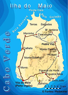
Pilão Cão is a settlement in the eastern part of the island of Maio in Cape Verde. In 2010 its population was 102. It is located 1 km south of Alcatraz and 14 km northeast of the island capital Porto Inglês.
Praia Gonçalo is a settlement in the northeast of the island of Maio in Cape Verde. In 2010 population was 67. It is located 2 km north of Pedro Vaz and 18 km northeast of the island capital Porto Inglês.
Ribeira Prata is a settlement in the northwestern part of the island of São Nicolau, Cape Verde. In 2010 its population was 343. It is situated near the north coast, 3 km northeast of Praia Branca and 11 km north of Tarrafal de São Nicolau.
Pico da Cruz is a settlement in the northeastern part of the island of Santo Antão, Cape Verde. In 2010 its population was 138. It is situated 6 km southwest of Pombas and 10 km northeast of the island capital Porto Novo. Its elevation is about 1,400 meters. The village is named after the nearby mountain Pico da Cruz. It lies in the Cova-Paul-Ribeira da Torre Natural Park.
Palhal is a settlement in the western part of the island of São Nicolau, Cape Verde. In 2010 its population was 100. It is situated 2 km west of Cabeçalinho and 5 km northeast of Tarrafal de São Nicolau.

Monte Largo is a settlement in the southern part of the island of Fogo, Cape Verde. It is situated 1.5 km northeast of Salto, 3 km southeast of Monte Grande, 3 km west of Achada Furna and 13 kilometres (8.1 mi) east of the island capital São Filipe. At the 2010 census its population was 274. Its elevation is about 800 meters.
Baía is a settlement in the eastern part of the island of Santiago, Cape Verde. It is part of the municipality of São Domingos. In 2010 its population was 489. It is situated near the east coast, 2 km southeast of Achada Baleia, 2 km northwest of Moia Moia and 14 km northeast of Praia. It sits at an elevation of about 20 meters. The settlement consists of several localities, including Achada Baixo, Castelinho and Covão Santana. The ruined Gothic church of Nossa Senhora da Luz, which was part of the 15th century Portuguese settlement Alcatrazes, stands at the shore near Baía.