Praia Gonçalo

Last updated
Praia Gonçalo
Cape Verde location map.svg
Red pog.svg
Coordinates: 15°16′01″N23°06′50″W / 15.267°N 23.114°W / 15.267; -23.114 Coordinates: 15°16′01″N23°06′50″W / 15.267°N 23.114°W / 15.267; -23.114
Country Cape Verde
Island Maio
Municipality Maio
Civil parish Nossa Senhora da Luz
Population (2010) [1]
  Total 67

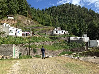
Praia Gonçalo is a settlement in the northeast of the island of Maio in Cape Verde. It 2010 population was 67. It is located 18 km northeast of the island capital Porto Inglês. It is also a beach covering the northeast of the island.

Maio, Cape Verde easternmost of the Sotavento islands; municipality (concelho) of Cape Verde

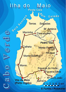
Maio is the easternmost of the Sotavento islands of Cape Verde. Maio is located south of the island of Boa Vista and east of Santiago. Administratively, the island forms one concelho (municipality): Maio.

Cape Verde Country comprising ten islands off the Northwest coast of Africa

Cape Verde or Cabo Verde, officially the Republic of Cabo Verde, is an island country spanning an archipelago of 10 volcanic islands in the central Atlantic Ocean. It forms part of the Macaronesia ecoregion, along with the Azores, Canary Islands, Madeira, and the Savage Isles. In ancient times these islands were referred to as "the Islands of the Blessed" or the "Fortunate Isles". Located 570 kilometres (350 mi) west of the Cape Verde Peninsula off the coast of Northwest Africa, the islands cover a combined area of slightly over 4,000 square kilometres (1,500 sq mi).

Porto Inglês Settlement in Maio, Cape Verde

Porto Inglês is a city in the southwestern part of the island of Maio in southeastern Cape Verde. It is the main urban settlement of the island, and also seat of the Maio Municipality. Its population was 2,971 in 2010. The name Porto Inglês refers to English ships that exported salt produced on the island of Maio from this town. Salt exploitation continued until the 19th century. The inconclusive Battle of Maio was fought between British and French frigate squadrons close to the town on 23 January 1814 in the last stages of the Napoleonic Wars.

Contents

It is connected as a branch road with the Barreiro-Cascabulho Road, the East Maio Route.

Barreiro, Cape Verde Settlement in Maio, Cape Verde

Barreiro is a town in the southern part of the island of Maio, Cape Verde. It is around 5 km east of the island capital Porto Inglês. At the 2010 census, its population was 535.

Cascabulho Settlement in Maio, Cape Verde

Cascabulho is a village in the northern part of the island of Maio in Cape Verde. In 2010 its population was 204. It is located 15 km northeast of the island capital Porto Inglês. Further north is the nature reserve Terras Salgadas.

The beach would be first named as "Praya Gonçalo" along with the settlement later, which was the Middle Portuguese name used up to the 1911 Orthography Reform made by Portugal which removed the y and became replaced with an i. [2] , but in Cape Verdean Creole, the older form continued to be used up to the mid-20th century and continued in Maio Creole.

Maio Creole is the name given to the variant of Cape Verdean Creole spoken mainly in the Maio Island of Cape Verde. It belongs to the Sotavento Creoles branch. It numbers the entire island population which includes a small part which also speaks Portuguese, in 2005, the percentage was 1.36%.

Nature

Recently small portions mainly within the streams hav become forested. Further west outside the area is the heavily forested portion of the island, forested with acacia and tamarisk trees.

Some birds and lizards dominate the land fauna including the Maio wall gecko (Tarentola maioensis). In the marine portion by the beach are rich in sea fauna including fishes, octopuses, sea plants and mollusks (molluscs), notably sea slugs, nudibranchs and sea snails such as cone snails, including endemic types, one endemic type founded is Conus gonsalensis [3] founded in the area by the beach and the northeast of the island. It has no relation to Conus gonsaloi as that species are not founded in the area.

The Maio wall gecko is a species of geckos in the family Phyllodactylidae. The species is endemic to Cape Verde, where it occurs on the island of Maio. The species was named by Hans Hermann Schleich in 1984. The specific name maioensis refers to the island of Maio, the type locality.

Conus gonsalensis is a species of sea snail, a marine gastropod mollusc in the family Conidae, the cone snails, cone shells or cones.

<i>Conus gonsaloi</i> species of Gastropoda

Conus gonsaloi is a species of sea snail, a marine gastropod mollusc in the family Conidae, the cone snails, cone shells or cones.

See also

Related Research Articles

Lomba, Cape Verde Settlement in Fogo, Cape Verde

Lomba is a settlement in the northwestern part of the island of Fogo, Cape Verde. In 2010 its population was 731. It is situated 10 km northeast of the island capital São Filipe.

Lagariça Settlement in Fogo, Cape Verde

Lagariça is a settlement in the western part of the island of Fogo, Cape Verde. It is situated 6 km northeast of the island capital São Filipe. One of its localities is named Coxo.

Atalaia, Cape Verde Settlement in Fogo, Cape Verde

Atalaia is a settlement in the northern part of the island of Fogo, Cape Verde. Its population was 700 in 2010. It is situated near the coast, 6 km west of Mosteiros and 19 km northeast of the island capital São Filipe. The municipal boundary with São Filipe is to the west. Nearby settlements area Ribeira Ilhéu to the east and Campanas Baixo to the west. The festival of Saint John is celebrated every June 24.

Santo António (Fogo) Settlement in Fogo, Cape Verde

Santo António is a settlement in the western part of the island of Fogo, Cape Verde. It is situated 6 km northeast of the island capital São Filipe.

Ribeira do Ilhéu Settlement in Fogo, Cape Verde

Ribeira do Ilhéu is a settlement in the northern part of the island of Fogo, Cape Verde. It is situated 6 km west of Mosteiros and 20 km northeast of the island capital São Filipe. The nearest village is Atalaia, 1.5 km to the southwest. The village's main festival is the festival of Saint Joseph that takes place on March 19.

Fajãzinha, Cape Verde Settlement in Fogo, Cape Verde

Fajãzinha is a settlement in the northern part of the island of Fogo, Cape Verde. It is situated on the coast, 3 km northwest of Mosteiros and 23 km northeast of the island capital São Filipe. Each year on May 13, the festival of Our Lady of Fatima is celebrated in the settlement.

Curral Grande Settlement in Fogo, Cape Verde

Curral Grande is a settlement in the western part of the island of Fogo, Cape Verde. It is situated 8 km northeast of the island capital São Filipe. In 2010 its population was 398. The village sits at 289 meters above sea level.

Galinheiro Settlement in Fogo, Cape Verde

Galinheiro is a settlement in the northwestern part of the island of Fogo, Cape Verde. In 2010 its population was 877. It is situated 2 km northeast of Ponta Verde, 2.5 km southwest of São Jorge and 13 km northeast of the island capital São Filipe.

Campanas Baixo Settlement in Fogo, Cape Verde

Campanas Baixo is a settlement in the northern part of the island of Fogo, Cape Verde. It is situated 2 km east of São Jorge, 2 km southwest of Atalaia and 16 km northeast of the island capital São Filipe.

Relva, Cape Verde Settlement in Fogo, Cape Verde

Relva is a settlement in the eastern part of the island of Fogo, Cape Verde. It is situated near the coast, 7 km southeast of Mosteiros and 23 km northeast of the island capital São Filipe.

Eito Settlement in Santo Antão, Cape Verde

Eito is a village in the northeastern part of the island of Santo Antão, Cape Verde, part of the municipality of Paul. It is situated 1 km southwest of Pombas, 2 km northeast of Figueiral and 15 km northeast of the island capital Porto Novo. Its population was 979 in 2010.

Janela, Cape Verde Settlement in Santo Antão, Cape Verde

Janela is a settlement in the eastern part of the island of Santo Antão, Cape Verde. It is situated on the Atlantic coast, 4 km southeast of Pombas and 14 km northeast of the island capital Porto Novo The central village, Pontinha, lies on a rocky peninsula. More villages are situated in the valley of the river Ribeira da Janela. The national road from Porto Novo to Pombas (EN1-SA03) passes through Janela.

Cabeçalinho Settlement in São Nicolau, Cape Verde

Cabeçalinho is a settlement in the western part of the island of São Nicolau, Cape Verde. In 2010 its population was 155. It is situated 3 km southwest of Ribeira Brava and 6 km northeast of Tarrafal de São Nicolau. To its northwest is Monte Gordo.

Pedro Vaz, Cape Verde Settlement in Maio, Cape Verde

Pedro Vaz is a settlement in the northeast of the island of Maio in Cape Verde. It is located 3.5 km north of Alcatraz and 16 km northeast of the island capital Porto Inglês.

Pilão Cão Settlement in Maio, Cape Verde

Pilão Cão is a settlement in the eastern part of the island of Maio in Cape Verde. In 2010 its population was 102. It is located 1 km south of Alcatraz and 14 km northeast of the island capital Porto Inglês.

Ribeira Prata Settlement in São Nicolau, Cape Verde

Ribeira Prata is a settlement in the northwestern part of the island of São Nicolau, Cape Verde. In 2010 its population was 343. It is situated near the north coast, 3 km northeast of Praia Branca and 11 km north of Tarrafal de São Nicolau.

Pico da Cruz (village) Settlement in Santo Antão, Cape Verde

Pico da Cruz is a settlement in the northeastern part of the island of Santo Antão, Cape Verde. In 2010 its population was 138. It is situated 6 km southwest of Pombas and 10 km northeast of the island capital Porto Novo. Its elevation is about 1,400 meters. The village is named after the nearby mountain Pico da Cruz. It lies in the Cova-Paul-Ribeira da Torre Natural Park.

Palhal, Cape Verde Settlement in São Nicolau, Cape Verde

Palhal is a settlement in the western part of the island of São Nicolau, Cape Verde. In 2010 its population was 100. It is situated 2 km west of Cabeçalinho and 5 km northeast of Tarrafal de São Nicolau.

Monte Largo Settlement in Fogo, Cape Verde

Monte Largo is a settlement in the southern part of the island of Fogo, Cape Verde. It is situated 1.5 km northeast of Salto, 3 km southeast of Monte Grande, 3 km west of Achada Furna and 13 kilometres (8.1 mi) east of the island capital São Filipe. At the 2010 census its population was 274. Its elevation is about 800 meters.

Baía, Cape Verde Settlement in Santiago, Cape Verde

Baía is a settlement in the eastern part of the island of Santiago, Cape Verde. It is part of the municipality of São Domingos. In 2010 its population was 489. It is situated near the east coast, 2 km southeast of Achada Baleia, 2 km northwest of Moia Moia and 14 km northeast of Praia. It sits at an elevation of about 20 meters. The settlement consists of several localities, including Achada Baixo, Castelinho and Covão Santana. The ruined Gothic church of Nossa Senhora da Luz, which was part of the 15th century Portuguese settlement Alcatrazes, stands at the shore near Baía.

References

  1. "2010 Census results". Instituto Nacional de Estatística Cabo Verde (in Portuguese). 24 November 2016.
  2. "Relatório das Bases da Reforma Ortográfica" (PDF). Diário de Governo. 12 September 1911.
  3. Cossignani T. & Fiadeiro R. (2014). Cinque nuovi coni da Capo Verde. Malacologia Mostra Mondiale. 84: 21- 27 page(s): 25