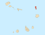
Sal is an island in Cape Verde. Sal is a tourist destination with white sandy beaches and over 350 days of sunshine a year. It is one of the three sandy eastern islands of the Cape Verde archipelago in the central Atlantic Ocean, 350 mi (560 km) off the west coast of Africa. Cabo Verde is known for year-round kiteboarding, for the large reserve of Caretta turtles which hatch from July to September, and the music of Cesaria Evora.

Boa Vista, also written as Boavista, is a desert-like island that belongs to the Cape Verde Islands. At 631.1 km2 (243.7 sq mi), it is the third largest island of the Cape Verde archipelago.

Santiago is the largest island of Cape Verde, its most important agricultural centre and home to half the nation's population. Part of the Sotavento Islands, it lies between the islands of Maio and Fogo. It was the first of the islands to be settled: the town of Ribeira Grande was founded in 1462. Santiago is home to the nation's capital city of Praia.

Santa Maria is a city in the southern part of the island municipality of Sal, Cape Verde. It is located on the south coast, about 16 km south of the Amílcar Cabral International Airport, and 20 km south of the island capital Espargos.

Sal Rei is a city on the northwestern coast of the island of Boa Vista in eastern Cape Verde. Sal Rei is the island's main urban settlement, and the seat of the Boa Vista Municipality. In 2010 its population was 5,778. The name of the settlement means "Salt King" in Portuguese. This name stems from when the island's main industry was salt production.

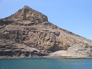
Monte Estância is a mountain in the southeastern part of the island Boa Vista in Cape Verde. At 387 m elevation, it is the island's highest point. It is located 4 km from the Atlantic coast and 23 km southeast of the island capital Sal Rei. It is part of a protected natural space under the statute of natural monument, which covers 739 ha.

Estádio Marcelo Leitão is a multi-use stadium in Sal Island, Cape Verde. It is used mostly for football matches and now track and field and has a capacity of 8,000 people. It is named for Marcelo Leitão, one of the two main features on the island, the other is a square located in Santa Maria. The stadium is owned by the municipality of Sal and still does as the municipality has yet to split into two. The stadium are operated by the Sal Regional Football (Soccer) and Athletic associations. It is the home stadium of Espargos teams, Académico do Aeroporto and others based in a neighborhood Juventude and recently Chã de Matias, Gaviões, Jovens Unidos of Ribeira Funda and Pretória, it is also home to the island's club Académica do Sal. The ground is made of artificial grass, its area is 105 x 68 meters. Its location is south of the road connecting the east of the city with the road encircling most of the city. The stadium also had recently constructed parking lots.
Serra Negra is a hill in the southeastern part of the island of Sal in Cape Verde. Its maximum elevation is 104 m, the highest point in southern Sal. It stretches for about 2.5 km along the east coast of the island, between the headland Ponta da Fragata in the south and the Ponta do Morrinho Vermelho in the north. The nearest settlement is Murdeira, to the west. The mountain forms part of a protected area as a nature reserve, important as nesting area for seabirds and turtles. The nature reserve covers 3.31 km2 (1.28 sq mi) of land and 22.96 km2 (8.86 sq mi) of ocean.

Monte Grande is a mountain in the northern part of the island of Sal in Cape Verde. It is situated 8 km northeast of the island capital Espargos. At 406 m elevation, it is the highest point of the island. It is a protected landscape because of its geological value; the protected area covers 1,309 ha. There are pillow lava formations on the coast.

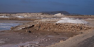
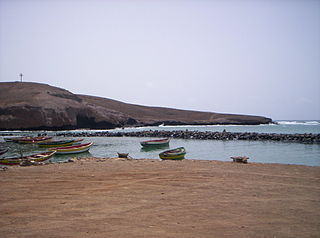
Pedra de Lume is a village in the northeastern part of the island of Sal, Cape Verde. The village is situated on the east coast, about 5 km east of the island capital Espargos. It has a small port and a lighthouse, Farol de Pedra de Lume.

Ilhéu de Sal Rei is an uninhabited islet near the coast of Boa Vista Island, Cape Verde. It is located 1 km southwest of the island capital Sal Rei. Its area is 89 ha (0.34 sq mi) and its highest point is 27 m (88.6 ft).

Ponta da Fragata is a headland on the east coast of the island of Sal, Cape Verde. It is situated at the southern end of the Serra Negra mountain, 6 km northeast of the town Santa Maria. To the south of the headland stretches the Costa da Fragata, a 4.7 km long sandy beach which is a protected nature reserve, important as nesting area for loggerhead sea turtles. The nature reserve covers 3.46 km2 (1.34 sq mi) of land and 23.47 km2 (9.06 sq mi) of ocean.
Rabo de Junco is a hill on the west coast of the island of Sal in Cape Verde. It is situated at the northern end of the Baía da Murdeira, 8 kilometres (5.0 mi) southwest of the island capital Espargos. Its steep eroded south face towards the bay is an important nesting area for birds. Rabo de Junco and the surrounding 154 hectares are protected as a nature reserve. It was mentioned as Rabadyunk in the 1747 map by Jacques-Nicolas Bellin. To its west lies the uninhabited islet Ilhéu Rabo de Junco.
Ponta Preta is a headland in the southwest of the island of Sal in Cape Verde. It is about 2 km west of the town Santa Maria and about 2 km of Ponta do Sinó, the southernmost point of the island. It lies within the nature reserve Ponta do Sinó, at the edge of a tourism development zone.

Curral Velho is a deserted village in the southern part of the island of Boa Vista, Cape Verde. The village is situated on the south coast, around 25 km southeast of the island capital of Sal Rei. The area around Curral Velho is a protected landscape, covering 16.35 square kilometres (6.31 sq mi). The nearby islet Ilhéu de Curral Velho and the adjacent coast are an important area for birds. The old houses of Curral Velho, São Domingos and Prazeres, examples of traditional Capeverdean architecture, are in a precarious state of conservation.

Praia de Atalanta is a beach on the north coast of the island of Boa Vista in Cape Verde. It is approximately 6 km northeast of the island capital of Sal Rei and 3 km west of Vigía. The wreck of the Spanish cargo ship Cabo Santa Maria, which ran aground on September 1, 1968, is located here.
Manuel António Martins was a Portuguese businessman and colonial governor of Cape Verde and Portuguese Guinea from 1834 to 1835. Martins was said to be the richest man in the country and nicknamed the Napoleon of the Cape Verde Islands. He arrived in Cape Verde in 1792. He started the exploitation of the salt ponds of Pedra de Lume on the island of Sal in 1796.
Cagarral is a mountain in the northeastern part of the island of Sal in Cape Verde. It is located near the east coast, 2 km northeast of Pedra de Lume and 6 km east of the island capital Espargos. To its east is the headland Ponta Trás de Cagarral. Together with the mountain and the saltpans to the west, it is a protected area as a protected landscape.
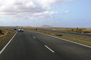
EN1-SL01 is a first class national road on the island of Sal, Cape Verde. It runs from Espargos to Santa Maria. It is Sal's only dual carriageway. In Espargos it is connected with EN1-SL-02 to Palmeira and EN3-SL-02 to Pedra de Lume. In Santa Maria it is connected with EN3-SL-01 to Ponta do Sinó.