Ilhéu de Sal Rei is an uninhabited islet near the coast of Boa Vista Island, Cape Verde. It is located 1 km southwest of the island capital Sal Rei. Its area is 89 ha (0.34 sq mi) and its highest point is 27 m (88.6 ft).

Ponta Norte is a headland on the north coast of the island of Sal in Cape Verde. It is the northernmost point of Sal. It is approximately 11 km north of the island capital of Espargos. The lighthouse Farol da Ponta Norte is located near the cape.

Ponta do Barril is a headland in the western part of the island of São Nicolau, Cape Verde. It is about 8 km northwest of Tarrafal de São Nicolau and 5 km southwest of the nearest village Praia Branca.

Ponta do Sol is a headland located in the northwest of the island of Boa Vista. Cape Verde. It is the island's northernmost point. The town Sal Rei is approximately 6 km (3.7 mi) to the south, and the hill Vigia is 2 km (1.2 mi) to the south.
Ponta Varandinha is a headland and the westernmost point of the island of Boa Vista, Cape Verde. To its north lies the beach Praia da Varandinha. The nearest village is Povoação Velha, 5 km to the east. There is a lighthouse on the cape. Its focal height is 22 meters and its range extends to 10 nautical miles.
Ponta Cais is a headland and the northernmost point of the island of Maio, Cape Verde. It is about 8 km north of the nearest village, Cascabulho. There is a lighthouse on the headland.

Farol de Fontes Pereira de Melo is a lighthouse at the northeastern point of the island of Santo Antão in northwestern Cape Verde. It is situated on the headland Ponta de Tumbo, 2 km east of Janela, 6 km southeast of Pombas and 15 km northeast of Porto Novo. The lighthouse was named after Fontes Pereira de Melo, prime minister of Portugal for several times between 1871 and 1886. It is a white octagonal masonry tower, 16 meters high. Its focal height is 162 meters above sea level, and its range is 17 nautical miles. The adjacent building for the lighthouse keeper is abandoned and in poor condition.

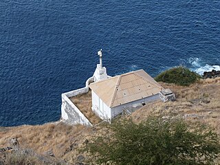
Farol de Dona Maria Pia is a lighthouse at the southernmost point of the island of Santiago, Cape Verde. It stands on the headland Ponta Temerosa, at the entrance of Praia Harbour, 2 km south of the city centre of Praia. The lighthouse was built in 1881 and was named after Maria Pia of Savoy, queen of Portugal at the time. The octagonal tower is 21 m high and its focal plane is 25 m above mean sea level. It is painted white. The lighthouse is used for navigational purposes.
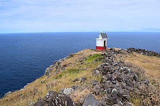
Farol de Ponta Norte is a lighthouse in the northernmost point of the island of Sal, Cape Verde. It is located near the headland Ponta Norte. The original lighthouse was a 13 metres high cast iron tower, constructed in 1897. This was replaced with a masonry tower around 1940, which is now in ruins. The current light is on a 5 metres metal tower.
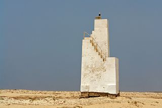
Farol da Ponta do Sinó is a lighthouse near Ponta do Sinó, the southernmost point of the island of Sal, Cape Verde. It is around 2 km southwest of the center of Santa Maria. The tower is quadrangular and is 9 meters tall and is made out of concrete, it has an outer staircase and features a lantern. All of the exterior are painted in white. The lighthouse was built in 1892. In early 2013, a second building with the same style was constructed and was finished before 2014 and became activated as the lighthouse moved to its new location.
Farol da Ponta Preta is a lighthouse in the northwesternmost part of the island of Santiago, Cape Verde. It stands on the headland Ponta Preta, 3 km northwest of the city Tarrafal. The lighthouse was constructed in 1889. Its lantern stands on a white column with a pyramidal base, in front of a small one storey building. The lighthouse was depicted on a Cape Verdean stamp in 2004.
Ponta Jalunga is a headland located nearly a kilometre northeast of the port of Furna on the island of Brava in southwestern Cape Verde. It is the northeasternmost point of the island. The promontory is a rocky area, up to 120 meters high. The headland was mentioned as Pt. Ghelongo in the 1747 map by Jacques-Nicolas Bellin.
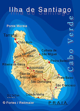
Ponta Moreia is the northernmost point of the island of Santiago, Cape Verde. It is about 2 km north of the nearest village, Fazenda, and around 5 km north of Tarrafal.

Ponta do Sinó is the southernmost point of the island of Sal in Cape Verde. It lies 2 km southwest of Santa Maria city centre. The area north of the headland is a protected area: nature reserve Ponta do Sinó, at the edge of a large tourism development zone. There is a lighthouse on the headland, Farol da Ponta do Sinó, built in 1892.
Ponta do Chão de Mangrade is the westernmost point of the Island of Santo Antão, and also the westernmost point of Cape Verde and all Africa. It is located 5 km northwest of Monte Trigo and 31 km west of Porto Novo, in a very remote area. The 1494 Treaty of Tordesillas divided the newly discovered lands outside Europe between Portugal and Spain along a meridian 370 leagues (2,193 km) west of this point.
Ponta Nhô Martinho is a headland on the Island of Brava, Cape Verde. It is the southernmost point of Cape Verde. It is located nearly 4 km south of Cachaço, the nearest settlement. Formerly, the point was called Salt Point, for instance in the 1747 map by Jacques-Nicolas Bellin. There is a lighthouse on Ponta Nhô Martinho, which is the southernmost structure in Cape Verde. Its focal plane is 29 metres (95 ft) above sea level.
Ponta do Sol is the northernmost point of both Cape Verde and the Island of Santo Antão. It is located 300 meters north of the city center of Ponta do Sol. The former Agostinho Neto Airport was located on the headland.
Ponta Leste is the easternmost point of the island of São Nicolau, Cape Verde. It is 8 km east of Carriçal and 30 km east of Ribeira Brava. The point was mentioned in a map in a 1747 atlas collection by Jacques-Nicolas Bellin as "Oost-Hoek" (Dutch), "Pointe de l'Est" (French"). It was sometimes known as East Point in English.
Ponta do Lobo Lighthouse is a lighthouse located near the headland named Ponta do Lobo, in the southeastern part of the island of Santiago, Cape Verde. The lighthouse is located about 4 km east of the nearest village, Vale da Custa, and 11 km northeast of the capital Praia. The lighthouse was built in 1887 and is the island's second oldest. It is a 9 metres high trapezoidal tower, attached to a single storey keeper's house. Its class of light is Fl (4) W 15s., its focal height is at 17 meters above sea level and its range is 10 nautical miles.