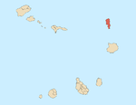
Boa Vista, also written as Boavista, is a desert-like island that belongs to the Cape Verde Islands. At 631.1 km2 (243.7 sq mi), it is the third largest island of the Cape Verde archipelago.

Santiago is the largest island of Cape Verde, its most important agricultural centre and home to half the nation’s population. Part of the Sotavento Islands, it lies between the islands of Maio and Fogo. It was the first of the islands to be settled: the town of Ribeira Grande was founded in 1462. Santiago is home to the nation's capital city of Praia.

Sal Rei is a city on the northwestern coast of the island of Boa Vista in eastern Cape Verde. Sal Rei is the island's main urban settlement, and the seat of the Boa Vista Municipality. In 2010 its population was 5,778. The name of the settlement means "Salt King" in Portuguese. This name stems from when the island's main industry was salt production.

The Cape Verdean Football Federation is the governing body of football in Cape Verde. It was founded in 1982, affiliated to FIFA in 1986 and to CAF in 2000. It organizes the national football league and the national team.

Estádio Marcelo Leitão is a multi-use stadium in Sal Island, Cape Verde. It is used mostly for football matches and now track and field and has a capacity of 8,000 people. It is named for Marcelo Leitão, one of the two main features on the island, the other is a square located in Santa Maria. The stadium is owned by the municipality of Sal and still does as the municipality has yet to split into two. The stadium are operated by the Sal Regional Football (Soccer) and Athletic associations. It is the home stadium of Espargos teams, Académico do Aeroporto and others based in a neighborhood Juventude and recently Chã de Matias, Gaviões, Jovens Unidos of Ribeira Funda and Pretória, it is also home to the island's club Académica do Sal. The ground is made of artificial grass, its area is 105 x 68 meters. Its location is south of the road connecting the east of the city with the road encircling most of the city. The stadium also had recently constructed parking lots.

The Radiotelevisão Caboverdiana is Cape Verde's first radio and television station broadcasting local programs from Cape Verde, Portugal and Brazil as well as the rest of the world especially France. It is a publicly owned company and enterprise and is located in the Capeverdean capital city of Praia, in the southern part in the middle of Achada Santo António RTC also has a few buildings, it also has offices in São Vicente, Sal, São Filipe on Fogo Island and Assomada in Santa Catarina. The building size is very small, only like local affiliates in North America as well as Latin America, Australia and Europe. The radio building is in the south on Rua 13 de Janeiro and the television station is in the north. Its current president is José Emanuel Tavares Moreira/

Ponta da Fragata is a headland on the east coast of the island of Sal, Cape Verde. It is situated at the southern end of the Serra Negra mountain, 6 km northeast of the town Santa Maria. To the south of the headland stretches the Costa da Fragata, a 4.7 km long sandy beach which is a protected nature reserve, important as nesting area for loggerhead sea turtles. The nature reserve covers 3.46 km2 (1.34 sq mi) of land and 23.47 km2 (9.06 sq mi) of ocean.

Ponta Preta is a headland in the southwest of the island of Sal in Cape Verde. It is about 2 km west of the town Santa Maria and about 2 km of Ponta do Sinó, the southernmost point of the island. It lies within the nature reserve Ponta do Sinó, at the edge of a tourism development zone.
The 2004 Cape Verdean Football Championship season was the 25th of the competition of the first-tier football in Cape Verde. Its started on 8 May and finished on 10 July, earlier than the last season. The tournament was organized by the Cape Verdean Football Federation.
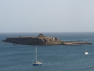
Ilhéu de Santa Maria is a small uninhabited islet of the Sotavento archipelago in Cape Verde located off the shore of the island Santiago. Like all Cape Verdean islands, the islet is of volcanic origin. The islet has an area of roughly 0.05 square kilometres and is 420 metres long and 130 metres wide. It is situated at the entrance of Praia Harbour, in front of Praia da Gamboa, near the city centre of Praia.
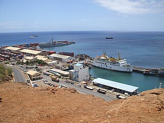
Praia Harbor is the port of the city of Praia in the southern part of the island of Santiago, Cape Verde. It is situated in a natural bay of the Atlantic Ocean. Since the latest modernization in 2014, it has 2 long quays, 3 shorter quays, a quay for fishing boats with fish processing installations, 2 container parks, 2 roll-on/roll-off ramps and a passenger terminal. The total length of the quays is 863 m, and the maximum depth is 13.5 m. The port of Praia played an important role in the colonization of Africa and South America by the Portuguese. With 817,845 metric tonnes of cargo and 85,518 passengers handled (2017), it is the second busiest port of Cape Verde, after Porto Grande (Mindelo).
1910s – 1920s – 1930s – 1940s – 1950s – 1960s – 1970s – 1980s – 1990s – 2000s
The Architecture of Cape Verde has different architectural styles in the nation. Unlike the African mainland, Cape Verde was uninhabited until 1461 when the Portuguese arrived, most of the other islands were first inhabited after the end of the 15th century. Its architecture was introduced in the 1460s and has its first origins from Portuguese settlers from the Madeira Islands, after the first arrival of mainland Africans, a bit of African architecture would be elements mainly in rural areas. The Manueline was its first architectural style on the island, it was later followed by Renaissance, Baroque, Pombaline, Early Modern and Modern. It was one of the last in the whole of Africa to introduce architecture late. Cape Verde has one of the richest architecture in the western portion of West Africa, the sub-Saharan portion, the richest probably being Mali.

Ponta do Sinó is the southernmost point of the island of Sal in Cape Verde. It lies 2 km southwest of Santa Maria city centre. The area north of the headland is a protected area: nature reserve Ponta do Sinó, at the edge of a large tourism development zone. There is a lighthouse on the headland, Farol da Ponta do Sinó, built in 1892.
The 2018 Taça Nacional de Cabo Verde is the 6th edition of the Taça Nacional de Cabo Verde, the knockout football competition of Cape Verde. The competition, which is played out in a tournament between the cup winners of the nine islands, returns for the first time since 2012.