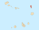
Espargos is the capital and main commercial centre of the island and municipality of Sal, Cape Verde. The city is situated in the heart of the island.

Lomba is a settlement in the northwestern part of the island of Fogo, Cape Verde. In 2010 its population was 731. It is situated 10 km northeast of the island capital São Filipe.

Lagariça is a settlement in the western part of the island of Fogo, Cape Verde. It is situated 6 km northeast of the island capital São Filipe. One of its localities is named Coxo.

Atalaia is a settlement in the northern part of the island of Fogo, Cape Verde. Its population was 700 in 2010. It is situated near the coast, 6 km west of Mosteiros and 19 km northeast of the island capital São Filipe. The municipal boundary with São Filipe is to the west. Nearby settlements area Ribeira Ilhéu to the east and Campanas Baixo to the west. The festival of Saint John is celebrated every June 24.

Santo António is a settlement in the western part of the island of Fogo, Cape Verde. It is situated 6 km northeast of the island capital São Filipe.

Ribeira do Ilhéu is a settlement in the northern part of the island of Fogo, Cape Verde. It is situated 6 km west of Mosteiros and 20 km northeast of the island capital São Filipe. The nearest village is Atalaia, 1.5 km to the southwest. The village's main festival is the festival of Saint Joseph that takes place on March 19.

Fajãzinha is a settlement in the northern part of the island of Fogo, Cape Verde. It is situated on the coast, 3 km northwest of Mosteiros and 23 km northeast of the island capital São Filipe. Each year on May 13, the festival of Our Lady of Fatima is celebrated in the settlement.

Curral Grande is a settlement in the western part of the island of Fogo, Cape Verde. It is situated 8 km northeast of the island capital São Filipe. In 2010 its population was 398. The village sits at 289 meters above sea level.

Eito is a village in the northeastern part of the island of Santo Antão, Cape Verde, part of the municipality of Paul. It is situated 1 km southwest of Pombas, 2 km northeast of Figueiral and 15 km northeast of the island capital Porto Novo. Its population was 979 in 2010.

Janela is a settlement in the eastern part of the island of Santo Antão, Cape Verde. It is situated on the Atlantic coast, 4 km southeast of Pombas and 14 km northeast of the island capital Porto Novo The central village, Pontinha, lies on a rocky peninsula. More villages are situated in the valley of the river Ribeira da Janela. The national road from Porto Novo to Pombas (EN1-SA03) passes through Janela.

Sinagoga is a settlement in the northeastern part of the island of Santo Antão, Cape Verde. It is situated on the coast, 4 kilometers east of Ribeira Grande and 18 km north-northeast of the island capital Porto Novo. It is situated on the national road connecting Ribeira Grande and Pombas (EN1-SA02).

Pombas is a city in the northeastern part of the island of Santo Antão, Cape Verde. It is the seat of the municipality Paul. It is situated on the coast, at the mouth of the Ribeira do Paul, 7 km (4.3 mi) southeast of Ribeira Grande and 15 km (9.3 mi) north of the island capital Porto Novo. The national roads EN1-SA02 and EN1-SA03 connect Pombas with Ribeira Grande and Porto Novo, respectively. Pombas was elevated from town to city in 2010.

Bofarreira is a village in the northern part of the island of Boa Vista in the Cape Verde archipelago. The village is around 10 km east of the island capital of Sal Rei.

Cabeça dos Tarrafes is a village in the eastern part of the island of Boa Vista, Cape Verde. The village is located about 2 km south of Fundo das Figueiras and 21 km southeast of the island capital of Sal Rei. It is one of the easternmost communities in Cape Verde.

Estância de Baixo is a settlement in the western part of the island of Boa Vista, Cape Verde. Its population was 578 in 2010, making it the island's third most populated place. The village is around 6 km southeast of the island capital of Sal Rei, west of the Deserto de Viana, on the eastern bank of Ribeira do Rabil.

Povoação Velha is a village in the southwestern part of the island of Boa Vista, Cape Verde. The village is around 16 km south of the island capital Sal Rei.

Morro is a settlement in the west of the island of Maio in Cape Verde. It is located 5 km north of the island capital Porto Inglês and 6 km south of Calheta. As of the 2010 census, its population was 310. The beach north of the village, Praia do Morro, is a 6.66 km2 nature reserve.

Praia Baixo is a village in the southeastern part of the island of Santiago, Cape Verde. It is part of the municipality of São Domingos and the parish of Nossa Senhora da Luz. It is situated on the east coast, 1.5 km northwest of Achada Baleia, 11 km southeast of Pedra Badejo, 10 km east of São Domingos and 16 km north of the capital Praia. In 2010 its population was 952.

Feijoal is a village on the island of Fogo, Cape Verde. It lies close to the town Mosteiros, at about 220 meters elevation. Its population was 435 at the 2010 census. The main festival in the settlement is Saint Anthony which is on June 13.


