Known as the "Land of a Thousand Hills", Rwanda’s high elevation gives it a temperate tropical highland climate. Its location within the Great Rift Valley contributes to a diverse landscape that includes volcanoes, savannas, and freshwater lakes.
The Kagera and Ruvubu rivers, part of the upper NileEnlargeable, detailed map of Rwanda
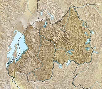
The watershed between the major Congo and Niledrainage basins runs from north to south through Rwanda, with around 80 percent of the country's area draining into the Nile and 20 percent into the Congo via the Rusizi River.[5] The country's longest river is the Nyabarongo, which rises in the south-west, flows north, east, and southeast before merging with the Akanyaru to form the Kagera; the Kagera then flows due north along the eastern border with Tanzania. The Nyabarongo-Kagera eventually drains into Lake Victoria, and its source in Nyungwe Forest is a contender for the as-yet undetermined overall source of the Nile.[6]
Rwanda has many lakes, the largest being Lake Kivu. This lake occupies the floor of the Albertine Rift along most of the length of Rwanda's western border, and with a maximum depth of 480 metres (1,575ft),[7] it is one of the twenty deepest lakes in the world.[8] Other sizeable lakes include Burera, Ruhondo, Muhazi, Rweru, and Ihema, the last being the largest of a string of lakes in the eastern plains of Akagera National Park.[9]
Mountains dominate central and western Rwanda. These mountains are part of the Albertine Rift Mountains that flank the Albertine branch of the East African Rift. This branch runs from north to south along Rwanda's western border.[10] The highest peaks are found in the Virunga volcano chain in the northwest; this includes Mount Karisimbi, Rwanda's highest point, at 4,507 metres (14,787ft).[11]
Rain in Kigali (January 2020)
This western section of Rwanda, which lies within the Albertine Rift montane forests ecoregion,[10] has an elevation of 1,500 to 2,500 metres (4,921 to 8,202ft).[12] The centre of the country is predominantly rolling hills, while the eastern border region consists of savanna, plains and swamps.[13]
Rwanda has a temperatetropical highland climate, with lower temperatures than are typical for equatorial countries due to its high elevation. Kigali, in the centre of the country, has a typical daily temperature range between 12 and 27°C (54 and 81°F), with little variation through the year.[14] There are some temperature variations across the country; the mountainous west and north are generally cooler than the lower-lying east.[15]
There are two rainy seasons in the year. The first runs from February to June and the second from September to December. These are separated by two dry seasons: the major one from June to September, during which there is often no rain at all, and a shorter and less severe one from December to February.[16] Rainfall varies geographically, with the west and northwest of the country receiving more precipitation annually than the east and southeast.[17]
Administratively, Rwanda is divided into four provinces (intara): the Northern, Southern, Eastern, and Western, together with the City of Kigali, which serves as both the national capital and an independent administrative entity.[19][20][21] These provinces and the city are subdivided into districts (akarere), which serve as the main level of local government.[22]
Rwanda shares strong cross-border trade and transport links with its neighbours. Key regional infrastructure routes include the Central Corridor, which connects Rwanda through Tanzania to the port of Dar es Salaam, and the Northern Corridor, linking the country via Uganda and Kenya to the port of Mombasa.[23][24] These routes connect Rwanda to regional and international markets and support its economic integration within the East African Community (EAC).
Physical geography
Relief of Rwanda
Rwanda is situated in eastern-central Africa. The country covers an area of about 26,338km2 (10,169sqmi), of which roughly 6 percent is water. The country lies entirely within the Nile Basin and the Congo Basin, separated by a watershed that runs north–south across the western part of the country. This divide gives Rwanda its nickname, the "land of a thousand hills."
Major rivers include the Nyabarongo River, which flows northward and then southward into the Akagera River, forming part of the upper Nile River system. Lakes are scattered throughout the country, the largest being Lake Kivu on the western frontier, while Lakes Burera and Ruhondo lie in the north. The eastern region contains a network of smaller lakes and marshlands, including the Akagera National Park wetlands.
Rwanda has a tropical savanna climate and a subtropical highland climate (Köppen climate classificationAw and Cwb/Cfb), influenced by its elevation and proximity to the equator. The country experiences moderate temperatures throughout the year, with significant regional variation between the high mountains in the west and northwest and the lower, warmer plains in the east.
Average daytime temperatures in Kigali range between 25°C (77°F) and 28°C (82°F), while night-time temperatures remain around 15°C (59°F). Cooler conditions prevail in the highlands of the Northern Province and the Western Province near the Volcanoes National Park.
Rwanda has two rainy seasons and two dry seasons each year.
The long rainy season extends from March to May.
The short rainy season occurs from October to December.
The long dry season lasts from June to September, and the short dry season from January to February.
Rainfall is generally heaviest in the western and northern regions and decreases toward the east and southeast. Annual precipitation in Kigali averages about 1,100mm (43in), though totals can exceed 1,500mm (59in) in mountainous zones.
Average humidity in Kigali remains between 70 and 90 percent depending on the season. Rainfall variability, especially during El Niño and La Niña years, continues to influence agriculture, water availability, and flood risk.[28][29]
Environment
Rwanda’s environment is shaped by its highland geography and dense population, both of which put pressure on natural resources. The country’s ecosystems include mountain forests, savannas, and wetlands, which together support rich biodiversity despite the small national territory.[30]
Natural hazards
Natural hazards in Rwanda include periodic droughts and floods, particularly during the rainy seasons, as well as volcanic activity in the Virunga Mountains in the northwest, along the border with the Democratic Republic of the Congo. The most active volcano is Mount Nyiragongo, which poses a regional risk of lava flows and gas emissions.[31]
Environmental issues
Major environmental challenges include deforestation for fuel and agriculture, soil erosion, overgrazing, wetland degradation, and loss of biodiversity. Rwanda’s growing population has intensified land use, contributing to soil exhaustion and pressure on arable land.[32] The government has responded with large-scale reforestation, terracing, and wetland restoration programs, including the rehabilitation of the Nyandungu Urban Wetland Eco-Park in Kigali.[33]
Conservation and climate policy
Rwanda has established strict environmental protection policies under the Rwanda Environment Management Authority (REMA) and the Green Growth and Climate Resilience Strategy adopted in 2011. The country has banned plastic bags, promoted renewable energy use, and introduced policies for sustainable land and water management.[34]
International agreements
Rwanda is a party to the following international agreements:
This page is based on this Wikipedia article Text is available under the CC BY-SA 4.0 license; additional terms may apply. Images, videos and audio are available under their respective licenses.