
Burundi is located in East Africa, to the east of the Democratic Republic of the Congo, at the coordinates 3°30′S30°0′E.

The geography of Egypt relates to two regions: North Africa and West Asia.

The Nile is a major north-flowing river in northeastern Africa. It flows into the Mediterranean Sea. The Nile is the longest river in Africa and has historically been considered the longest river in the world, though this has been contested by research suggesting that the Amazon River is slightly longer. Of the world's major rivers, the Nile is one of the smallest, as measured by annual flow in cubic metres of water. About 6,650 km (4,130 mi) long, its drainage basin covers eleven countries: the Democratic Republic of the Congo, Tanzania, Burundi, Rwanda, Uganda, Kenya, Ethiopia, Eritrea, South Sudan, Sudan, and Egypt. In particular, the Nile is the primary water source of Egypt, Sudan and South Sudan. Additionally, the Nile is an important economic river, supporting agriculture and fishing.

Tanzania comprises many lakes, national parks, and Africa's highest point, Mount Kilimanjaro. Northeast Tanzania is mountainous, while the central area is part of a large plateau covered in grasslands. The country also contains the southern portion of Lake Victoria on its northern border with Uganda and Kenya.

Rwanda is located in East Africa, to the east of the Democratic Republic of the Congo, at the co-ordinates 2°00′S30°0′E.

Uganda is located in Eastern Africa, West of Kenya, South of South Sudan, East of the Democratic Republic of the Congo, and North of Rwanda and Tanzania. While much of its border is on lakeshores, Uganda is landlocked with no access to the sea port but it is a fertile and well-watered country that consists of many lakes and rivers including the largest, Lake Victoria. The country sits in the heart of the Great Lakes region, with Lake Edward, Lake George and Lake Albert on its Western border, Lake Kyoga in the Eastern part of Uganda. It is found in Central Saharan Africa and receives reliable rainfall throughout the year. Rivers are River Nile the longest river in Africa, River Kagera, River Katonga, River Semiliki and River Sezibwa.

The White Nile is a river in Africa, the minor of the two main tributaries of the Nile, the larger being the Blue Nile. The name "White" comes from the clay sediment carried in the water that changes the water to a pale color.

Kagera Region is one of Tanzania's 31 administrative regions. The region covers an area of 35,686 km2 (13,778 sq mi). The region is comparable in size to the land area of the Netherlands. Kagera Region is bordered to the east by Lake Victoria, Mwanza Region and Mara Region. The region is bordered to the south by Geita Region and Kigoma Region. Lastly, Kagera borders Rwanda to the west, Uganda to the north and Burundi to the south west. The regional capital city is Bukoba. According to the 2022 national census, the region had a population of 2,989,299, an increase from 2,458,023 recorded in 2012.

The Kagera River, also known as Akagera River, or Alexandra Nile, is an East African river, forming part of the upper headwaters of the Nile and carrying water from its most distant source. With a total length of 597 km (371 mi) from its source located in Lake Rweru in Rwanda.

Akagera National Park is a protected area in eastern Rwanda covering 1,122 km2 (433 sq mi) along the international border with Tanzania. It was founded in 1934 and includes savannah, montane and swamp habitats. The park is named for the Kagera River which flows along its eastern boundary feeding into Lake Ihema and several smaller lakes. The complex system of lakes and linking papyrus swamps makes up over a third of the park, which is the largest protected wetland in Eastern-Central Africa.

Rusumo Falls is a waterfall located on the Kagera river on the border between Rwanda and Tanzania, part of the most distant headwaters of the river Nile. The falls are approximately 15 m (49 ft) high and 40 m (130 ft) wide and have formed on Precambrian schists and quartz–phyllites.
The Ruvubu River is a river in central Africa whose waters gather from the most distant, southern portion of the Nile basin. With a total length of 416 km (258 mi) and has a drainage basin of 14,000 km2 (5,400 sq mi). It rises in the north of Burundi, near the town of Kayanza and then does a southward arc through Burundi, being joined by the Ruvyironza River near Gitega. From there it runs northeast, through the Ruvubu National Park, up to the Tanzanian border. After a stretch along the border, the Ruvubu crosses properly into Tanzania, before joining the Nyabarongo River on the Tanzania–Rwanda border near Rusumo Falls, to form the Kagera River.
Tourism in Rwanda is the largest source of foreign exchange earnings in Rwanda. It was projected to grow at a rate of 25% every year from 2013-2018. The sector is the biggest contributor to the national export strategy. Total revenue generated from the sector in 2014 alone was USD 305 million.

The wildlife of Burundi is composed of its flora and fauna. The small, landlocked country is home to 2,950 species of plants, 596 birds, 163 species of mammals, 52 species of reptiles, 56 species of amphibians, and 215 fish species. The wildlife has been drastically reduced in recent years, mainly on account of intense population pressure, conversion of large areas of forest into agricultural land, and extensive livestock farming. The protected area encompasses little more than 5% of the total area of the country.
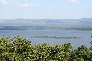
Lake Cyohoha South or Cyohoha Sud as it is known in Rwanda or Lake Cohoha in Burundi is a small lake in East Africa. It straddles the border between Burundi and Rwanda. In Rwanda, it is known as Cyohoha South to differentiate it from the nearby much smaller Cyohoha North 10 miles North into Rwanda. In Burundi, it is simply known as Cohoha. It is a narrow yet very long lake with many branches. It is 32 km (20 mi) in length, and has an average of 1 km (1 mi) in width. It is largely bisected by the border between Rwanda and Burundi, however, its southern portion extends entirely into Burundi. The lake is 74 km2 (30 sq mi), of which 19 km2 (10 sq mi) are in Rwanda and 55 km2 (20 sq mi) belong to Burundi.
The Nyabarongo is a major river in Rwanda, part of the upper headwaters of the Nile. With a total length of 351 km (218 mi), it is the longest river entirely in Rwanda. It is extended 421 km (262 mi) in Lake Rweru including a 69 km (43 mi) upper course of Kagera River before joining into Ruvuvu River to form the Kagera River. The river begins its course at the confluence of the rivers Mbirurume and Mwogo in the South West of the country. These two rivers themselves begin in Nyungwe Forest, and are considered by some to be the most distant source of the Nile. From its start, Nyabarongo flows northward for 85 km, and forms the border between the Western and Southern Provinces. At the confluence with the river Mukungwa, the river changes course and flows eastward for 12 km, then to a more South Eastern course for the last 200 km. For the longest stretch of this course, the river serves as the boundary between the Northern and Southern Provinces, then between the City of Kigali and the Southern Province, and lastly between the City of Kigali and the Eastern Province.

Lake Burera or Bulera is a lake of northwestern Rwanda, at the border with Uganda. With an area pf 55 km2 (20 sq mi), it is the second largest lake entirely in Rwanda after Lake Ihema. Considering all other lakes in the country, it would be the 5th largest after Lake Kivu 2,700 km2 (1,040 sq mi) between Rwanda and the Democratic Republic of the Congo, Lake Rweru between Rwanda and Burundi at 133 km2 (50 sq mi) of which only 47 km2 (20 sq mi) are in Rwanda, Lake Ihema and Lake Cohoha 74 km2 (30 sq mi) also shared with Burundi of which only 19 km2 (10 sq mi) are in Rwanda. The lake is located in a densely populated North of the country in Burera District which got its name from this lake. The closet major city is the city of Musanze 25 km (16 mi) West of the lake.
Lake Ihema is a lake in the east of Rwanda, at the border with Tanzania. The lake lies within the marshland of the Kagera River in which it empties via a very short channel. With an area of 100 km2 (40 sq mi), it is the largest lake entirely in Rwanda. Considering all other lakes in the country, it would be the 3rd largest after Lake Kivu 2,700 km2 (1,040 sq mi) between Rwanda and the Democratic Republic of the Congo and Lake Rweru between Rwanda and Burundi at 133 km2 (50 sq mi) of which only 47 km2 (20 sq mi) are in Rwanda. The lake is located in Kayonza District in the southern part of Akagera National Park which contains more than another dozen of lakes, of which Ihema is the largest.

The Protected Aquatic Landscape of the North, also called the Northern Protected Waterway or Northern Protected Waterscape, is a protected area in Kirundo Province, Burundi. It covers eight lakes in the north of the province, and a forest. It was designated Ramsar site no. 2149 in March 2014.
Lake Kanzigiri is a lake in the Kirundo Province of Burundi.
