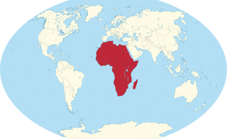
Africa is a continent comprising 63 political territories, representing the largest of the great southward projections from the main mass of Earth's surface. Within its regular outline, it comprises an area of 30,368,609 km2 (11,725,385 sq mi), excluding adjacent islands. Its highest mountain is Mount Kilimanjaro; its largest lake is Lake Victoria.

Chad is one of the 47 landlocked countries in the world and is located in North Central Africa, measuring 1,284,000 square kilometers (495,755 sq mi), nearly twice the size of France and slightly more than three times the size of California. Most of its ethnically and linguistically diverse population lives in the south, with densities ranging from 54 persons per square kilometer in the Logone River basin to 0.1 persons in the northern B.E.T. (Borkou-Ennedi-Tibesti) desert region, which itself is larger than France. The capital city of N'Djaména, situated at the confluence of the Chari and Logone Rivers, is cosmopolitan in nature, with a current population in excess of 700,000 people.
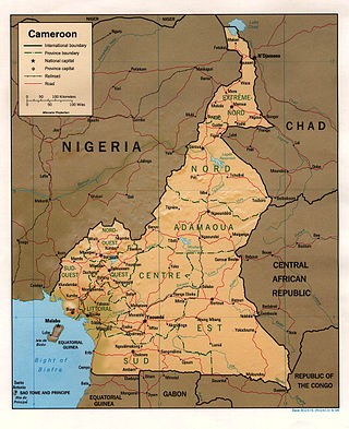
At 475,440 km2 (183,570 sq mi), Cameroon is the world's 53rd largest country. It is slightly larger than the nation of Sweden and the US state of California. It is comparable in size to Papua New Guinea. Cameroon's landmass is 472,710 km2 (182,510 sq mi), with 2,730 km2 (1,050 sq mi) of water.

El Salvador is a country in Central America. Situated at the meeting point of three tectonic plates, it is highly seismologically active and the location of numerous earthquakes and volcanic eruptions. The country has a tropical climate.

Russia is the largest country in the world, covering over 17,125,192 km2, and encompassing more than one-eighth of Earth's inhabited land area. Russia extends across eleven time zones, and has the most borders of any country in the world, with sixteen sovereign nations.
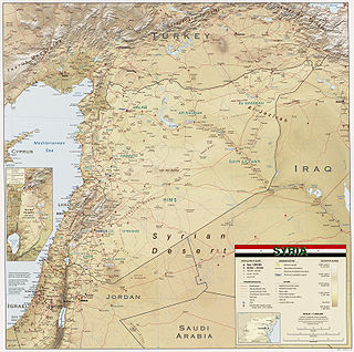
Syria is located in Western Asia, north of the Arabian Peninsula, at the eastern end of the Mediterranean Sea. It is bordered by Turkey to the north, Lebanon and Israel to the west and southwest, Iraq to the east, and Jordan to the south. It consists of mountain ranges in the west and a steep area inland. In the east is the Syrian Desert and in the south is the Jabal al-Druze Range. The former is bisected by the Euphrates valley. A dam built in 1973 on the Euphrates created a reservoir named Lake Assad, the largest lake in Syria. The highest point in Syria is Mount Hermon on the Lebanese border at 2,814 metres or 9,232 feet. Between the humid Mediterranean coast and the arid desert regions lies a semiarid steep zone extending across three-quarters of the country, which receives hot, dry winds blowing across the desert. Syria is extensively depleted, with 28 percent of the land arable, 4 percent dedicated to permanent crops, 46 percent utilized as meadows and pastures, and only 3 percent forest and woodland.

The term "United States," when used in the geographical sense, refers to the contiguous United States, the state of Alaska, the island state of Hawaii, the five insular territories of Puerto Rico, Northern Mariana Islands, U.S. Virgin Islands, Guam, and American Samoa, and minor outlying possessions. The United States shares land borders with Canada and Mexico and maritime borders with Russia, Cuba, The Bahamas, and other countries, in addition to Canada and Mexico. The northern border of the United States with Canada is the world's longest bi-national land border.
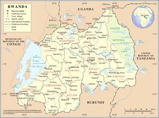
Rwanda is located in East Africa, to the east of the Democratic Republic of the Congo, at the co-ordinates 2°00′S30°0′E.
Landforms are categorized by characteristic physical attributes such as their creating process, shape, elevation, slope, orientation, rock exposure, and soil type.

The Harney Basin is an endorheic basin in southeastern Oregon in the United States at the northwestern corner of the Great Basin. One of the least populated areas of the contiguous United States, it is located largely in northern Harney County, bounded on the north and east by the Columbia Plateau—within which it is contained, physiographically speaking—and on the south and west by a volcanic plain. The basin encompasses an area of 1,490 square miles (3,859 km2) in the watershed of Malheur Lake and Harney Lake. Malheur Lake is a freshwater lake, while Harney Lake is saline-alkaline.

The North Island Volcanic Plateau is a volcanic plateau covering much of central North Island of New Zealand with volcanoes, lava plateaus, and crater lakes. It contains the Taupō caldera complex, Ōkataina caldera complex and Tongariro Volcanic Centre resulting in it being currently the most frequently active and productive area of silicic volcanism on Earth. New Zealand is part of the Pacific Ring of Fire.

Ruhengeri, also known as Musanze or Muhoza, is the third largest city in Rwanda and the capital of Musanze District in the Northern Province of Rwanda. The city has a population of 135,000 as of the 2022 census.
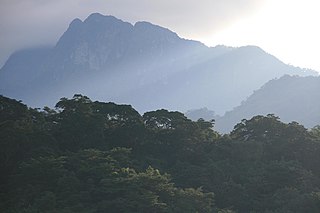
The Udzungwa Mountains are a mountain range in south-central Tanzania. The mountains are mostly within Iringa Region, south of Tanzania's capital Dodoma. The Udzungwa Mountains are part of the Eastern Arc Mountains, and are home to a biodiverse community of flora and fauna with large numbers of endemic species.

The Albertine Rift is the western branch of the East African Rift, covering parts of Uganda, the Democratic Republic of the Congo (DRC), Rwanda, Burundi and Tanzania. It extends from the northern end of Lake Albert to the southern end of Lake Tanganyika. The geographical term includes the valley and the surrounding mountains.
Tourism in Rwanda is the largest source of foreign exchange earnings in Rwanda and was projected to grow at a rate of 25% every year from 2013-18. The sector is the biggest contributor to the national export strategy. Total revenues generated from the sector in 2014 alone was USD 305 millions. The sector has also attracted direct foreign investments with major international hotel brands setting up shop in the country including Marriot Hotels & Resorts, Radisson Blu, Park Inn by Radisson, Sheraton Hotels and Resorts, Protea Hotels by Marriott, Golden Tulip Hotels, and Zinc. With its new world-class convention center Rwanda is set to become a regional and international conference hub owing to ever improving conference facilities, an excellent and expanding transportation network, and straightforward immigration procedures such as the ability for online visa applications, visa-at-gate policy for all Africans, and a one tourist visa policy for the EAC.
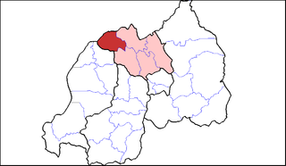
Musanze is a district in the Northern Province of Rwanda. Its capital city is Ruhengeri.

Burera is a district (Akarere) in Northern Province, Rwanda. Its capital is Cyeru.
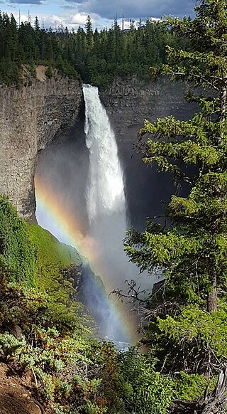
Wells Gray Provincial Park is a large wilderness park located in east-central British Columbia, Canada. The park protects most of the southern, and highest, regions of the Cariboo Mountains and covers 5,415 square kilometres. It is British Columbia's fifth largest provincial park, after Tweedsmuir, Tatshenshini, Spatsizi and Northern Rocky Mountains.

Lake Burera or Bulera is a lake of northwestern Rwanda, at the border with Uganda. With an area pf 55 km2 (20 sq mi), it is the second largest lake entirely in Rwanda after Lake Ihema. Considering all other lakes in the country, it would be the 5th largest after Lake Kivu 2,700 km2 (1,040 sq mi) between Rwanda and the Democratic Republic of the Congo, Lake Rweru between Rwanda and Burundi at 133 km2 (50 sq mi) of which only 47 km2 (20 sq mi) are in Rwanda, Lake Ihema and Lake Cohoha 74 km2 (30 sq mi) also shared with Burundi of which only 19 km2 (10 sq mi) are in Rwanda. The lake is located in a densely populated North of the country in Burera District which got its name from this lake. The closet major city is the city of Musanze 25 km (16 mi) West of the lake.


