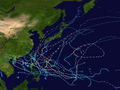
The 2003 Pacific typhoon season was a below average yearlong period of tropical cyclogenesis exhibiting the development of 45 tropical depressions, of which 21 became named storms; of those, 14 became typhoons. Though every month with the exception of February and March featured tropical activity, most storms developed from May through November. During the season, tropical cyclones affected the Philippines, Japan, China, the Korean Peninsula, Indochina, and various islands in the western Pacific.
The season ran year-round, with the first storm, Yanyan, developing west of the Marshall Islands on January15. In April, Typhoon Kujira became one of the longest-lasting Pacific typhoons in history and attained climatological records for its unusually early impacts. Typhoon Imbudo in July caused several deaths and extensive damage across the Philippines and China. In September, Typhoon Maemi became one of the costliest typhoons in recorded history after striking South Korea; Maemi was also the most intense tropical cyclone of the season with a minimum barometric pressure of 910mbar (hPa; 26.87inHg). In late November, Typhoon Lupit devastated areas of Yap State in the Federated States of Micronesia. The season closed with the dissipation of a tropical depression east of the Philippines on December27.
The scope of this article is limited to the Pacific Ocean, north of the equator and west of the International Date Line. Storms that form east of the date line and north of the equator are called hurricanes; see 2003 Pacific hurricane season. Tropical Storms formed in the entire west Pacific basin are assigned a name by the Tokyo Typhoon Center. Tropical depressions in this basin monitored by the Joint Typhoon Warning Center(JTWC) have the "W" suffix added to their number. Tropical depressions that enter or form in the Philippine area of responsibility are assigned a name by the Philippine Atmospheric, Geophysical and Astronomical Services Administration or PAGASA. This can often result in the same storm having two names.[1]
On March5, 2003, meteorologists from the University College London at the Tropical Storm Risk (TSR) Consortium issued an extended range forecast for the typhoon season, noting the likelihood of near average tropical cyclone activity as a result of projected neutral sea surface temperatures. The forecast indicated the potential for 26.2tropical storms, compared to the 10– and 30-year average of 27.8 and 26.3storms, respectively.[3] The following month, the group raised their forecast for tropical storms to 26.7, indicating a slightly above average season.[4] Over next two months, however, fluctuations in sea surface temperatures, particularly those in the Central Pacific, caused the group to revise their predictions downward and indicated the probability for a slightly below average typhoon season in their June forecast.[6] A rise in sea surface temperatures in the following months prompted the forecasting group to once again raise their forecasts to indicate a near-average season in their final August forecast update, which predicted 27tropical storms.[8] The group was very accurate in their forecasts, with their April and August forecasts being the most accurate.[2]
Similarly, meteorologists working with the City University of Hong Kong issued a seasonal projection on April24, 2003, indicating the likelihood of a normal or below normal season with 29total tropical cyclones, 26tropical storms, and 16typhoons. As with the TSR, the group primarily based their forecast numbers on the prevailing status of the El Niño-Southern Oscillation.[9] The City University of Hong Kong revised their forecasts on June 24, 2003, indicating a slight increase of total tropical cyclones to 30.[10] The group was also accurate in their forecasts for the entirety of the Northwest Pacific, though their specialized forecasts for the South China Sea were substantially off.[11]
The Accumulated Cyclone Energy (ACE) index for the 2003 Pacific typhoon season as calculated by Colorado State University using data from the Joint Typhoon Warning Center was 337.4units.[14]
Throughout the season, sea surface temperatures within the western equatorial Pacific were above normal, including those in the South China Sea. Areas of convection persisted year-round in the lower latitudes, particularly around the Philippines. Atmospheric divergence was also prevalent in the same regions, resulting in enhanced tropical cyclogenesis east of the Philippines in 2003; the mean region of development of tropical systems during the year was more southwest than the 1971–2000 30-year average. In 2003, the JMA monitored 21tropical cyclones of at least tropical storm intensity; of those, 14reached typhoon intensity. Though the number of tropical storms was below average, the ratio between tropical storms and typhoons was 66%greater than normal.[12] The Philippine Atmospheric, Geophysical and Astronomical Services Administration (PAGASA) monitored three additional cyclones of at least tropical storm intensity that were not monitored by the JMA.[1][15][16]
The season began with the formation of Tropical Storm Yanyan on January15, followed by Typhoon Kujira in mid-April.[12] Kujira was one of the longest lived Pacific storms on record and was the first typhoon with 1-minute sustained winds of at least 240km/h (150mph) in April since Typhoon Isa in 1997.[17] In July, typhoons Imbudo and Koni both tracked across the Philippines, the former killing 78people.[18][19] August was a highly active month for tropical cyclogenesis, with a total of six tropical storms monitored by the JMA, JTWC, and PAGASA. This included typhoons Krovanh and Dujuan, which also struck southeastern China. Typhoon Etau earlier in the month made landfall in Japan, resulting in 17deaths.[16][20] In September, Typhoon Maemi was the strongest tropical cyclone of the season and was the costliest with roughly US$4.8billion in damage,[nb 1] mostly in South Korea.[12][22][23] In October, two typhoons – Ketsana and Parma – existed simultaneously while staying away from land.[24][25]
On January11, a tropical disturbance originated near the International Date Line. Steered by a subtropical ridge to its north, the system tracked westward and developed into a tropical depression on January15, west of the Marshall Islands. The convection, or thunderstorms, waxed and waned. The JMA upgraded the depression to Tropical Storm Yanyan on January18, e stimating peak 10minute winds of 65km/h (40mph). The JTWC estimated 1minute winds of 95km/h (60mph). Around that time, the storm stalled east of the Mariana Islands and curve sharply northeastward into a less favorable environment. The JMA downgraded Yanyan to tropical depression at 1200UTC on January20. Soon thereafter, the storm transitioned into an extratropical cyclone as its low-level circulation center decoupled from the primary mass of convection due to strong wind shear. At 0000UTC on January21, both the JTWC and JMA discontinued the monitoring of Yanyan.[12][13][26]
A tropical depression formed on April9, which moved westward. It strengthened into Tropical Storm Kujira on Apil11, which attained typhoon status three days later. Late on April15, Kujira reached its peak intensity with winds of 165km/h (103mph) and a minimum barometric pressure of 930mbar (hPa; 27.46inHg). Afterward, the typhoon's track and intensity fluctuated as it passed east of the Philippines and Taiwan, with eventual wweakening as it turned to the north. On April24, Kujira was downgraded to tropical depression strength as it made landfall on Kyushu. Afterward, Kujira transitioned into an extratropical cyclone on April25, which persisted until crossing the International Dateline.[12][13][17]
Shortly after developing, Kujira caused two fatalities in Pohnpei in addition to minor agricultural and infrastructural damage;[17] similar effects were felt in Guam.[27] Several days later, the typhoon prompted cyclone warnings and other precautionary measures in the Philippines after forecasts indicated the potential for strong winds and rain.[28][29] However, ultimately any effects in the archipelago associated with Kujira remained minimal.[30] The typhoon also prompted warning products in Taiwan,[31] making it the first April typhoon since 1978 to cause such a feat.[17] Unlike in the Philippines, however, Kujira would bring significant rainfall to Taiwan.[32] Effects from the typhoon were most significant in Japan,[33] particularly in the Ryukyu Islands. Strong winds, rain, and waves caused US$230,000 (¥27.8million) in agricultural damage on Ishigaki Island. One person was killed due to injuries resulting from the waves.[34] In Kyushu, heavy rainfall, peaking at 196mm (7.7in) in Ōita Prefecture, was reported.[33] Overall, despite its distance away from land and weak intensity at the time of its sole landfall, Kujira resulted in three fatalities.[17][34]
A tropical depression formed on May19 to the southwest of Chuuk. A day later, it strengthened into Tropical Storm Chan-hom while moving generally to the north, steered by a shortwave trough. On May23, Chan-hom attained typhoon status, as it developed an eye. At 18:00UTC that day, the typhoon reached its peak intensity with maximum sustained winds of 155km/h (96mph) and a minimum pressure of 940 millibars (940hPa; 28inHg). Chan-hom began to intake dry air beginning on May25, resulting in weakening as it accelerated to the northeast. Increased wind shear striped convection from the center. Early on May27, Chan-hom transitioned into an extratropical cyclone, which dissipated south of the Aleutian Islands the following day.[1][13][12]
As a tropical storm, Chan-hom caused some damage to homes and crops on Chuuk, mostly due to heavy rains brought forth by the storm.[12] Offshore, a 1,040ton fishing vessel, the Nien Feioch, sank during the storm. The ship was valued at $16million.[35] Winds from the typhoon fanned volcanic ash from the recently erupting Anatahan volcano towards Guam, prompting precautionary measures.[1] Ashfalls were reported on the island, forcing the cancellation of several flights.[35]
A tropical depression formed off the western coast of Luzon on May25, quickly strengthening into Tropical Storm Linfa. The storm executed a small clockwise loop before hitting Luzon on May27. Linfa weakened over land before restrengthening over open waters. It reached its peak intensity on May29 with maximum sustained winds of 100km/h (62mph) and a barometric pressure of 980mbar (hPa; 28.94inHg). Linfa transitioned into an extratropical cyclone on May30, which moved through Japan and later dissipated in the Sea of Okhotsk on June4.[12][13][1]
The erratic and slow movement of Linfa off the western Philippines was the catalyst for extreme rainfall and flooding, killing 41persons in the archipelago. Precipitation peaked at 723mm (28.5in) near Dagupan.[1] Rising floodwaters resulted in the temporary shutdown of government offices and numerous mudslides.[36][37] In addition, strong winds caused widespread power outages.[36] Overall damage from Linfa in the Philippines amounted to ₱192.3million (US$3.65million).[1] The floods also displaced 8,367people in 1,686families and destroyed 178homes.[38][39] Linfa and its extratropical remnants later brought torrential rainfall and widespread flooding to Japan, particularly in southwestern regions. Rainfall there peaked at 727mm (28.6in).[40] Flood damage was worst in Kōchi and Tokushima Prefectures, where several buildings were destroyed by floodwater.[41][42] Other locations in Japan experienced considerable agricultural damage as well as numerous landslides.[43] Overall, Linfa caused roughly $28.2million in damage, much of which occurred in Japan, though the entirety of deaths associated with the cyclone took place in the Philippines.[1]
In late May, an area of disturbed weather began to persist in the South China Sea.[1] The JTWC began to monitor the storm cluster on May29.[13] The following day, the JMA reclassified the system as a tropical depression;[12] initially the system remained highly disorganized due to the lack of deep convection.[1] Persistent moderate wind shear and dry air prevented the cyclone from strengthening significantly in the storm's early stages.[13] These conditions abated as the depression tracked northeast, and at 0000UTC on June1, the JMA upgraded the system to Tropical Storm Nangka.[1][12] Throughout the course of the day, Nangka continued to strengthen as it accelerated northeast, and peaked in strength with a barometric pressure of 985mbar (985hPa; 29.1inHg) and maximum sustained winds of 95km/h (59mph), making it a severe tropical storm.[12]
However, upon moving through the Bashi Channel, conditions began to deteriorate due to increased wind shear, weakening the system and resulting in its downgrade to tropical depression status by the JMA at 1200UTC on June3.[12] Nangka continued to become increasingly disorganized as it moved further north,[1] and late that day, the depression transitioned to an extratropical cyclone. The resulting remnants continued to track well east of Japan before dissipating on June7.[12] Due to its track away from landmasses, damage remained minimal; however, as Nangka passed to the south and east of Japan, the storm brought light rainfall to the country, peaking at 81mm (3.2in) in Minamidaitō, Okinawa.[44]
A tropical depression formed northeast of Palau on June12. On June13, the JMA upgraded it to Tropical Storm Soudelor to the east of the Philippines, and PAGASA gave it the local name "Egay". The storm moved to the northwest and later to the north, parallel to the eastern Philippines, and on June17, the JMA upgraded it to typhoon status. Soudelor passed over the Japanese island of Iriomote-jima at around 2030UTC on June17. At 0600UTC on June18, the JTWC estimated peak 1minute winds of 215km/h (134mph), while the JMA estimated peak 10minute winds of 150km/h (93mph). On June19, Soudelor weakened and became extratropical near the Oki Islands. The remnants crossed northern Japan on June20 and dissipaed four days later.[12][13][45]
While offshore the Philippines, Soudelor dropped heavy rainfall that caused flooding and left thousands homeless.[13][45] The storm caused ₱131million (PHP, US$2.46million) in damage and 12deaths.[46] On the Japanese island of Iriomote-jima, where wind gusts reached 204km/h (127mph).[45] It also affected Taiwan, where floods covered highways and caused mudslides.[47] In Japan, the storm caused widespread power outages, although damage was minimal, and there were 21injuries.[48] In South Korea, there was $12.1million in damage and two deaths.[49]
On July15, the JMA estimated that a tropical depression formed,[12] and the next day the JTWC initiated advisories on Tropical Depression 09W about 665km (413mi) east of Yap. A subtropical ridge near Okinawa steered the nascent depression to the west-northwest for much of its duration. With warm waters and favorable upper-level conditions, the depression quickly organized,[13] first to Tropical Storm Imbudo on July17, and to typhoon status two days later,[12] when PAGASA begin issuing advisories on Typhoon Harurot.[19] Around that time, Imbudo was rapidly intensifying, developing a well-defined eye.[18] At 1200UTC on July20, the JMA estimated peak 10minute sustained winds of 165km/h (103mph),[12] and the same time, the JTWC estimated 1minute sustained winds of 240km/h (150mph), making it a super typhoon.[13] Imbudo maintained peak winds for about 12hours,[12] before undergoing an eyewall replacement cycle.[18] At 0300UTC on July22, Imbudo struck northern Luzon, with 1minute winds estimated at 205km/h (127mph) by the JTWC.[13] It weakened over land, but re-intensified in the South China Sea,[12] striking southern China near Yangjiang, Guangdong on July24.[50] Imbudo rapidly weakened, dissipating on July25.[12]
In the Philippines, officials evacuated over 14,000people.[50] Imbudo was the strongest typhoon to strike since Typhoon Zeb five years prior,[18] The typhoon left widespread areas flooded for several days.[51] Damage was heaviest in the Cagayan Valley, where over 80,000people were displaced by the storm.[52] In Isabela, high winds wrecked most of the banana crop and severely damaged other crops.[53] Throughout the Philippines, Imbudo damaged or destroyed 62,314houses,[52] causing P4.7billion (2003PHP, $86million 2003USD) in damage. There were 64deaths in the country.[19] In southern China in Yangjiang, more than 30,000people evacuated ahead of the storm,[54] and more than half of the trees in the city fell due to strong winds.[55] High winds killed a man in Hong Kong after knocking him off a platform.[50] Throughout Guangdong, Imbudo destroyed 595,000houses and caused eight deaths. Heavy rains spread across southern China, peaking at 343mm (13.5in) at Hepu County in Guangxi province. There, 12people died from the storm. Overall damage in China was about ¥4.45 billion (CNY, $297million USD).[18]
A tropical depression formed the east of the Philippines on July15 within the monsoon trough. It moved across the central Philippines as a tropical depression on July17. Soon after moving into the South China Sea, the cyclone reached tropical storm status on July18. A day later, Koni reached peak intensity with maximum sustained winds of 110km/h (68mph), making it a severe tropical storm. However, atmospheric conditions began to deteriorate as Koni made landfall on Hainan on July21, weakening the system. Koni weakened furhter as it moved over the Gulf of Tonkin, prior to a final landfall near Hanoi, Vietnam the following day. Tracking inland, Koni dissipates over Laos on July23.[12][18]
Shortly after development, Koni tracked through the Philippines, killing two people.[56] After moving into the South China Sea, turbulence produced by the storm resulted in an aviation incident involving a commercial airliner off the western Philippines. Three of the plane's occupants received minor injuries.[57] In Hainan, Koni caused heavy rainfall, peaking at 189mm (7.4in) at a station on Wuzhi Mountain. The rains resulted in the collapse of 1,400homes and an estimated CN¥140.27million (US$16.9million) in direct economic losses.[18] Effects were worst in Vietnam, where three people were killed.[58] Widespread power outages occurred, and strong winds resulted in agricultural and infrastructural damage, particularly in Vietnam's northern provinces.[13][56]
Morakot spawned from an area of disturbed weather in the Philippine Sea on July31.[16] Tracking northwest, favorable conditions allowed for the intensification of the system to tropical storm strength on August2. Morakot reached peak intensity later that day with winds of 85km/h (53mph) and a minimum barometric pressure of 992mbar (hPa; 28.29inHg).[12] Morakot made landfall on southern Taiwan on August3. Subsequently, the storm weakened and moved into the Taiwan Strait before making its final landfall near Quanzhou, China the next day.[13] The storm quickly weakened over the Chinese mainland, and dissipated entirely several hours after landfall.[12]
In Taiwan, where Morakot first made landfall, heavy rainfall resulted in flooding.[16] Commercial flights, schools, and rail service in some areas was cancelled in advance of the storm.[59][60] Precipitation there peaked at 653mm (25.7in) over a period of nearly two days in Taitung County.[16] Crop damage also resulted from the rainfall, and was estimated at over NT$70million (US$2million).[56] In China, record rainfall was reported. The worst impacted city was Quanzhou, where losses due to Morakot reached CN¥240million (US$29million) and one death was reported. Power outages were also widespread across southeastern China. Due to preexisting drought conditions, 703cloud seeding operations took place in order to artificially generate added rainfall; such operations resulted in moderate precipitation over the targeted area.[16] Overall, Morakot caused roughly $31million in damage and three deaths.[16][56]
A tropical depression developed on August2 southeast of Guam, and gradually intensified while moving to the northwest, becoming a tropical storm on August3 and a typhoon a day later.[12] Etau formed an eye and became a large storm by the time it approached Okinawa on August7.[16] The typhoon attained peak winds of 155km/h (96mph) before weakening slightly while turning to the northeast. Etau made landfall on the Japanese island of Shikoku on August8, and later moved across portions of Honshu and Hokkaido. After weakening to tropical storm status, the cyclone became extratropical on August9 and dissipated three days later.[12]
While passing northeast of the Philippines, the typhoon caused light damage in the archipelago.[61] The eye crossed over Okinawa,[16] where Etau left 166,800people without power and caused 10injuries.[62] Near where Etau first struck Japan, Muroto reported a peak wind gust of 166km/h (103mph), at the time the third strongest on record there.[16] The typhoon also dropped torrential rainfall peaking at 683mm (26.9in).[63] The combination of winds and rainfall caused landslides, particularly on Hokkaido.[64] Nationwide, Etau killed 20people, destroyed 708houses, and caused ¥35.1billion (JPY, $294.8million USD) in damage.[63]
A tropical depression formed within the monsoon trough, east of Chuuk State on August13, but it degenerated into a remnant low five days later. The remnants reorganized into a tropical depression on August19. A day later, it became Tropical Storm Krovanh, reaching typhoon status on August22. Shortly after, Krovanh made landfall on Luzon at peak intensity with winds of 120km/h (75mph). The typhoon emerged into the South China Sea as a much weaker tropical storm, though it was able to restrengthen over warm waters. Once again at typhoon intensity, Krovanh clipped Hainan before moving over the Leizhou Peninsula on its way to a final landfall near Cẩm Phả, Vietnam on August25. Quick weakening due to land interaction occurred as Krovanh moved across northern Vietnam, where the storm met its demise the following day.[1][12][13]
Krovanh first struck the Philippines, resulting in heavy rainfall and displacing approximately 1,000families.[1] The flooding caused severe damage and killed one person.[56] Krovanh's effects were much more severe in China.[1] In Hong Kong, eleven people were injured and isolated flooding occurred as a result of the typhoon's outer rainbands.[56] However, Guangdong Province, Hainan Province, and Guangxi were the Chinese regions most extensively impacted. The typhoon brought record wind gusts into Guangxi.[1] In those three regions combined, 13,000homes were estimated to have collapsed and a large swath of farmland was damaged. Two people were killed in China and economic losses approximated to ¥2.1 billion (US$253 million).[56] Due to its positioning and track, of all areas in Vietnam only the country's more northern regions were impacted by Krovanh.[65]Flash flooding occurred in earnest in those regions, and 1,000homes were flattened.[56][65] One person was killed and five others were injured in Vietnam.[66] Overall, the typhoon was responsible for the deaths of four persons.[1]
The monsoon trough spawned several tropical disturbances in the middle of August, one of which became Tropical Depression Lakay near the Philippines. On August18, an area of convection persisted on the southern side of a circulation,[16] developing into a tropical depression east of Luzon.[12] It moved quickly northward and later to the northwest in an area generally unfavorable for strengthening, such as the presence of wind shear and land interaction.[16] On August19, the JMA upgraded the depression to Tropical Storm Vamco to the east of Taiwan.[12] Later that day, the circulation passed just 55km (34mi) north of Taipei, although the convection was exposed that time.[16] On August20, the JMA assessed Vamco as dissipating in the Taiwan Strait,[12] although the JTWC continued advisories until the storm moved ashore in southeastern China.[16]
Rainfall in Taiwan reached 69mm (2.7in) in Ilan County.[16] On the island, the storm left several hundred houses without power due to a lightning strike.[67] On mainland China, rainfall peaked at 101mm (4.0in) in Wenzhou, Zhejiang, which were largely beneficial in easing drought conditions, while winds gusted to 100km/h (62mph). The storm damaged or destroyed 5,880houses and flooded 1,287ha (3,180 acres) of paddy fields, causing ¥38.6million (CNY, US$4.7million) in damage.[16]
On August27, a tropical depression developed about 520km (320mi) northwest of Guam, which initially drifted to the southwest before turning to the northwest. On August29, the JMA upgraded it to Tropical Storm Dujuan,[12] and that day PAGASA began issuing advisories on Tropical Storm Onyok.[68] The storm quickly intensified into a typhoon,[12] after developing an eye in the center.[16] On September1, the JMA estimated Dujuan attained peak 10minute winds of 150km/h (93mph),[12] and the JTWC assessed peak 1–minute winds of 230km/h (140mph). While near peak intensity, the center of Dujuan passed about 45km (28mi) south of the southern tip of Taiwan.[13] The typhoon weakened steadily and was a severe tropical storm by the time it made landfall on September2 just east of Hong Kong.[12] The JTWC estimated landfall winds of 185km/h (115mph),[13] making it the strongest typhoon to strike the Pearl River Delta since Typhoon Hope in 1979.[69] Dujuan rapidly weakened while continuing westward through China, dissipating on September3 over Guangxi.[12]
In the Philippines, Dujuan interacted with the monsoon to produce heavy rainfall,[70] killing one person.[71] While in the vicinity, Dujuan produced gusts of 100km/h (62mph) on Yonaguni, a Japanese subdivision of Okinawa.[72] Heavy rainfall in Taiwan reached 628mm (24.7in) in Pingtung County, and winds peaked at 176km/h (109mph) on Orchid Island before the anemometer was destroyed.[16] The caused about NT$200 (NWD, $115million USD) in crop damage, and killed three people.[73] Damage was minor in Hong Kong,[69] and four fishermen were missing and presumed drowned after their boat sank.[16] On the Chinese mainland, strong winds left 90% of the city of Shenzhen without power,[73] and killed 16construction workers due to a half-finished building collapsing.[69] Across Guangdong, the typhoon damaged crops and destroyed 54,000homes were destroyed.[16][74] Overall damage in China was estimated at ¥2.3billion (CNY, US$277million), and across Guangdong, the typhoon killed 40people.[73]
Typhoon Maemi formed on September4 from the monsoon trough in the western Pacific Ocean.[13] It slowly intensified into a tropical storm while moving northwestward, and Maemi became a typhoon on September8. That day, it quickly intensified due to favorable conditions, developing a well-defined eye and reaching peak maximum sustained winds of 195km/h (121mph). While near peak intensity, Maemi was decelerating and began turning to the north-northeast.[12][22] The eyewall soon after passed over the Japanese island of Miyako-jima on September10, producing the fourth lowest pressure on record in Japan after a pressure of 912mbar (26.9inHg) was recorded.[22] With warm waters, Maemi was able to maintain much of its intensity before it made landfall just west of Busan, South Korea on September12.[75] On Jeju Island, Maemi produced a peak wind gust of 216km/h (134mph) and a minimum pressure of 950mbar (28inHg), both setting records for the country,[75] and making it the most powerful typhoon to strike South Korea since record-keeping began in the country in 1904.[23] The typhoon became extratropical in the Sea of Japan the next day, although the remnants persisted for several more days, bringing strong winds to northern Japan.[12]
The typhoon first affected the Ryukyu Islands of Japan.[12] On Miyako-jima, strong winds damaged 104buildings,[76] and 95% of residents lost power.[77] Maemi dropped heavy rainfall there, including rates of 58.5mm (2.30in) in an hour, and 402.5mm (15.85in) in 24hours, the latter setting a record.[22] One person died on Miyako-jima after being struck by flying glass.[78] Elsewhere in Japan, the storm caused flights to be canceled,[79] while rainfall-induced landslides blocked roads.[80] There were two other deaths in Japan, and damage totaled ¥11.3billion (JPY, $96million USD).[81] Damage was heaviest in South Korea, notably where it moved ashore. Winds in Busan near the landfall location reached 154km/h (96mph), the second-highest on record.[82] There, the port sustained heavy damage, causing disruptions to exports in the months following the storm. Nationwide, the high winds destroyed about 5,000houses and damaged 13,000homes and businesses, leaving 25,000people homeless.[23][83] About 1.47million lost power,[84] and widespread crop damage occurred, resulting in the worst rice crop in 23years.[85] Across South Korea, Maemi killed 117people,[75] and overall damage totaled ₩5.52trillion won (US$4.8billion).[23]
In the middle of September, the monsoon trough spawned a rapidly organizing disturbance east-northeast of Luzon,[13] with weak wind shear and favorable conditions.[22] On September16, the JMA classified it as a tropical depression,[12] and the JTWC initiated advisories the next day.[13] The system moved to the northwest due to the subtropical ridge to the northeast and later to the north.[13] On September18, the JMA upgraded the depression to Tropical Storm Choi-wan, the same day that PAGASA classified it as Tropical Storm Roskas (the only time this name was used, as it was retired the following year). An eastward-moving trough turned the storm to the northeast,[22] bringing the track over Okinawa and Amami Ōshima on September19. Choi-wan continued gradually intensifying, becoming a typhoon on September20 to the southeast of Japan. That day, the JMA estimated peak winds of 130km/h (81mph),[12] and the JTWC estimated peak 1minute winds of 185km/h (115mph) on September21,[13] after Choi-wan developed a well-defined eye. The typhoon weakened due to increasing wind shear, deteriorating to severe tropical storm status on September22 before JMA declared it extratropical on September23. The remnants of Choi-wan continued to the northeast, exited the basin on September24,[12] and eventually struck southern Alaska on September25.[24]
Wind gusts in Okinawa reached 115km/h (71mph), while on the volcanic island of Hachijō-jima, gusts reached 214km/h (133mph). On the Japanese mainland, winds gusted to 126km/h (78mph) at Chōshi, Chiba.[22] Choi-wan dropped heavy rainfall while near Japan, peaking at 316mm (12.4in) on Miyake-jima.[86] In Okinawa, Choi-wan flooded a boat, forcing its occupants to be rescued by the Coast Guard. Also on the island, heavy rainfall caused landslides and flooded houses.[87] In Amami Ōshima, the storm left 10,810people without power.[88] On Hachijō, wind gusts of 214km/h (133mph) damaged about 200houses.[89] Nationwide, Choi-wan destroyed 191homes, injured 9people, and left about ¥300million (JPY, US$2.5million).[86]
Towards the end of September, the monsoon trough spawned a tropical disturbance east-northeast of Yap,[13] which became a tropical depression on September24. There were initially several circulations, with a tropical upper tropospheric trough to the northeast increasing outflow. After slowing and turning to the northeast, the depression intensified into Tropical Storm Koppu on September26. After the storm developed a large eye feature, the JTWC upgraded it to typhoon status on September27, although the JMA did not follow suit until the following day while near Chichi-jima. Also that day, Koppu passed 95km (59mi) west of Iwo Jima, and the JMA estimated peak 10minute winds of 130km/h (81mph).[12][22] The JTWC estimated peak 1minute winds of 165km/h (103mph), before an approaching trough caused the typhoon to accelerate northeastward.[13] The convection diminished near the center, causing Koppu to become extratropical on September30.[22] The remnants continued generally northeastward through the Aleutian Islands, eventually passing south of mainland Alaska on October7.[24]
On Chichi-jima, Typhoon Koppu produced sustained winds of 102km/h (63mph), with gusts to 200km/h (120mph), which was the third strongest on record for the station.[22] Rainfall there reached 183mm (7.2in).[90] Wind gusts on Iwo Jima peaked at 109km/h (68mph).[22]
Tropical Depression 19W developed on October12 after an extratropical storm produced an area of convection. Described as a subtropical low, the depression moved generally northeastward toward Japan due to an approaching cold front.[25] The depression moved through Kyushu and Honshu before dissipating on October13.[13] The depression dropped 285mm (11.2in) of rainfall at Ikegawa in Kōchi, while strong winds associated reached 217km/h (135mph) through a storm-produced downburst. The winds knocked over two cranes, killing two people, and left about 9,000homes without power. The depression also killed two people due to drownings.[25]
In the middle of October, an area of convection persisted along the monsoon trough between Luzon and Guam, developing into a tropical depression on October17. The same monsoon trough later spawned Typhoon Parma to the east. For several days, the system remained disorganized while drifting to the west-northwest due to weak steering currents south of the subtropical ridge. On October19, the JMA upgraded the depression to Tropical Storm Ketsana, and by that time the storm had begun drifting to the northeast. With favorable outflow, Ketsana quickly intensified into a typhoon on October20 after developing an eye, and two days later, the JMA estimated peak winds of 165km/h (103mph). The JTWC estimated peak 1minute winds of 230km/h (140mph) around the time the well-defined eye had expanded to 37km (23mi). Subsequently, the typhoon accelerated northeastward into the westerlies and began weakening due to increasing wind shear and dry air. On October26, Ketsana became extratropical to the east of Japan and dissipated the next day.[12][13][25] The passage of the typhoon caused surface chlorophyll a concentration in the ocean to increase 30-fold.[91]
The same monsoon trough that spawned Typhoon Koppu also produced an area of convection to the north-northeast of Guam, becoming a tropical depression on October19. The system moved northwestward and later turned to the northeast around the subtropical ridge. With low wind shear and favorable outflow, the convection became better organized, and the JMA upgraded it to Tropical Storm Parma on October21. After an eye began to form, Parma was upgraded to typhoon status the next day. An approaching trough caused Parma to accelerate northeastward while also increasing outflow. On October24, the JMA estimated peak winds of 175km/h (109mph) while the JTWC estimated winds of 240km/h (150mph), an unusually high intensity for 30° N. Subsequently, Parma rounded the subtropical ridge and began moving to the east-southeast, beginning a nearly week-long loop.[12][13][25] The cold front had passed to the north and failed to bring the typhoon northeastward.[24]
Increasing wind shear weakened the convection, and Parma deteriorated into a severe tropical storm on October26. The next day, it began moving westward while passing about 345km (214mi) north of Wake Island. A large eye of 110km (68mi) in diameter developed, and on October28, the JMA re-upgraded Parma to typhoon status. The next day, the typhoon turned to the northeast due to another approaching trough. With decreasing wind shear and warmer waters, Parma re-intensified significantly on October29, reaching a secondary peak of 165km/h (103mph) according to JMA, and 215km/h (134mph) according to JTWC. The storm moved very closely along the track it took several days prior. Increasing wind shear on October30 caused rapid weakening, resulting in the eye dissipating. By the next day, the center was exposed, and Parma became extratropical, later exiting the basin on November1.[12][13][25] The remnants weakened, later turning to the southeast and dissipating on November11 southwest of California.[24]
On October22, a tropical depression developed in the South China Sea, classified by PAGASA as Ursula. The system moved eastward and crossed Palawan before dissipating on October 24.[25] In the Philippines, the depression killed one person and caused minor damage.[92]
Late in October, an area of convection persisted northwest of Palau and quickly organized into a tropical depression on October29. Moving west-northwestward toward the Philippines due to a ridge to the east, the depression intensified into Tropical Storm Melor on October30. With minimal wind shear, the storm strengthened further and developed a large eye. The JTWC upgraded Melor to typhoon status on October31, estimating peak 1minute winds of 140km/h (87mph), although the JMA estimated the storm only attained peak 10minute winds of 95km/h (59mph). Early on November1, Melor made landfall on northeastern Luzon in the Philippines, south of Palanan. The storm weakened over land and emerged into the South China Sea. By that time, it was moving northward along the periphery of the ridge to the east. On November2, Melor turned to the northeast, passing just east of Taiwan. The next day, it weakened to tropical depression status, and after meandering offshore eastern Taiwan, Melor continued northeastward. It became extratropical on November5 and dissipated the next day near southern Japan.[12][13][25]
In the Philippines, Melor dropped about 150mm (5.9in) of rainfall, which flooded the Cagayan River and killed four people.[93] In Taiwan, rainfall reached 554mm (21.8in) in Pingtung County.[25] On the Japanese island of Hateruma, rainfall totaled 197mm (7.8in),[94] which broke the hourly and daily record for the station in November.[25]
A tropical depression developed near Yap on November11, which strengthened into Tropical Storm Nepartak a day later, also named Weng by PAGASA. Moving westwardm Nepartak made landfall on northern Samar Island in the Philippines as a tropical storm on November 13. It crossed the island chain and emerged into the South China, where it quickly re-intensified. The JTWC estimated peak winds of 140km/h (87mph) on November16, and later that day, the JMA upgraded the storm to typhoon status, estimating peak 10-minute winds of 120km/h (75mph). On November18, Nepartak passed near southwestern Hainan and weakened. By the next day, the system weakened to tropical depression status, and dissipated shortly after moving ashore over Beihai, China.[95][13][12]
In the Philippines, Nepartak produced strong winds, heavy rainfall, and rough seas, killing at least four people.[96][95] The storm caused widespread power outages and ferry disruptions.[97][98] On Hainan, the storm helped end one of the worst summer droughts in almost 65years,[13] although it also left heavy crop damage, wrecking 64,000ha (160,000 acres) of fields and killing 400 head of livestock.[99] With about 800 homes destroyed, damage on Hainan amounted to $197 million (2003 USD).[13][95] Effects were minor in mainland China.[100]
Typhoon Lupit formed on November18 from the monsoon trough to the west of the Marshall Islands.[12][13] Early in its duration, it moved generally to the west or west-southwest. On November21, the depression intensified into Tropical Storm Lupit, and two days later, it strengthened into a typhoon,[12] developing an eye. Lupit later began a prolonged movement to the northwest, during which it passed near several islands in Yap State.[95] The typhoon reached peak intensity on November26, with peak 10–minute sustained winds of 185km/h (115mph).[12] It later weakened due to a variety of unfavorable conditions,[95] and after recurving to the northeast, Lupit became extratropical south of Japan on December2.[12]
Typhoon Lupit first affected Pohnpei with gusty winds, and later it damaged or destroyed about 200homes in Chuuk State. There, high waves flooded roads and homes, while high winds damaged crops. Damage was heaviest in Yap State, mostly in the small Ulithi atoll and Fais Island. On both islands, the typhoon contaminated the water supply and wrecked the crops. Rainfall reached 263mm (10.4in) on Ulithi, and gusts reached 158km/h (98mph). Throughout the FSM, damage totaled about $1.7million, although there were no deaths.[101] The damage prompted the FSM government to declare two states as disaster areas,[102] as well as a disaster declaration from the United States federal government.[103] While Lupit was becoming extratropical, it became the first typhoon in December to threaten Japan in 13years.[104] The storm dropped rainfall that resulted in mudslides and flight cancellations.[105][106]
Other systems
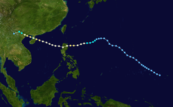
Satellite image of the final tropical depression of the year, located east of the Philippines
On May16, an area of convection formed to the southwest of Palau, located within an area of weak wind shear. The next day, the JMA and the JTWC both classified the system as a tropical depression. The convection was disorganized in association with multiple circulation centers, although it gradually organized. Moving westward initially, the depression turned more to the north into an area of increasing wind shear. On May19, the JTWC upgraded the system to Tropical Storm 03W,[1] and on the same day, PAGASA classified it as Tropical Depression Batibot.[107] Soon after, the convection decreased from the center, and by May20, all warning agencies had discontinued advisories.[1]
On July 9, PAGASA classified a system as Tropical Depression Falcon, off the west coast of the Philippines. The JMA also briefly initiated advisories before dropping them later on July 10.[18] On July 30, PAGASA briefly issued advisories on Tropical Depression Ineng off the east coast of Mindanao.[18]
The monsoon trough spawned a tropical depression north of Luzon on August18, with PAGASA naming it Lakay. There were several circulations in the region, with Tropical Storm Vamco to the northeast near Taiwan, and the overall system moved generally westward. PAGASA briefly classified Lakay as a tropical storm on August19 before ending advisories the next day. The system spread rainfall across China, reaching 82.4mm (3.24in) in Xiamen, Fujuan.[16]
On September5, former Hurricane Jimena crossed the International Date Line into the basin. By that time, the circulation was largely exposed from the convection, and the center quickly dissipated.[16] Later in September, the monsoon trough spawned a disturbance east of the Philippines that PAGASA classified as Tropical Depression Quiel on September15. The system moved westward but never intensified, dissipating west of Luzon on September19. The broad system also spawned Typhoon Choi-wan.[22][108]
On October5, the JMA monitored a tropical depression southeast of Taiwan that later passed near the island, producing heavy rainfall that peaked at 153mm (6.0in) in Ilan County. On October 6, the JTWC classified Tropical Depression 18W early in the month off the west coast of Luzon. With weak steering currents, the system moved slowly southwestward before looping to the northwest. On October10, the depression dissipated just off the coast of southern China. On October 16, the JMA briefly classified a tropical depression to the east of the Marianas Islands.[13][25] On October 21, a monsoon trough spawned a tropical depression in the Gulf of Thailand,[13] which moved northwestward and crossed into the Indian Ocean, dropping heavy rainfall in Thailand.[25]
In mid-November, the JMA briefly tracked a weak tropical depression near Wake Island.[95] The agency also briefly tracked a tropical depression off the coast of Vietnam on December 16. It finally dissipated on December 17, with the pressure and winds unknown.[109] The final system of the year was a tropical depression that originated out of the monsoon trough on December24 east of the Philippines. After initially moving to the west, it turned to the south, and the JTWC estimated the depression intensified into a tropical storm.[13] During this time, PAGASA classified it as Tropical Storm Zigzag.[110] The system made landfall in northeastern Mindanao and dissipated on December 27, bringing heavy rainfall.[109]
Storm names
Within the North-western Pacific Ocean, both the Japan Meteorological Agency (JMA) and the Philippine Atmospheric, Geophysical and Astronomical Services Administration assign names to tropical cyclones that develop in the Western Pacific, which can result in a tropical cyclone having two names.[15] The Japan Meteorological Agency's RSMC Tokyo— Typhoon Center assigns international names to tropical cyclones on behalf of the World Meteorological Organization's Typhoon Committee, should they be judged to have 10-minute sustained windspeeds of 65km/h (40mph).[111] While the Philippine Atmospheric, Geophysical and Astronomical Services Administration assigns names to tropical cyclones which move into or form as a tropical depression in their area of responsibility located between 135°E and 115°E and between 5°N-25°N even if the cyclone has had an international name assigned to it.[15] The names of significant tropical cyclones are retired, by both PAGASA and the Typhoon Committee.[111]
Following the season, the names Imbudo and Maemi were retired, and replaced by Molave and Mujigae, respectively. Hong Kong requested the removal of Yanyan, to be replaced by Dolphin. The name Koni had its spelling corrected to Goni.[112][113] PAGASA retired the name Harurot from their naming lists, replacing it with Hanna.[114]
Season effects
The following table provides basic meteorological and impact information for each tropical cyclone from the 2003 Pacific typhoon season in tabular format; unnamed tropical cyclones are not included. PAGASA names for storms are provided in parentheses. Storms entering from the Central Pacific only include their information while in the western Pacific, and are noted with an asterisk *.
↑"Weakened Kujira spares the Philippines, heads for Taiwan". Manila, Philippines. Agence France Presse. April 22, 2003.–viaLexis Nexis (subscription required)
12"ROUNUP: Taiwan issues warnings for typhoon Kujira". Taipei, Taiwan. Deutsche Presse-Agentur. April 21, 2003.–viaLexis Nexis (subscription required)
12Newman, Steve (April 26, 2003). "Earthweek: A diary of the planet". The Vancouver Sun. Vancouver, British Columbia. Tribune Media Services. p.G7.–viaLexis Nexis (subscription required)
12KITAMOTO Asanobu. "Typhoon 200302 (KUJIRA)". National Institute of Informatics. Retrieved October 6, 2013.
↑"ROUNDUP: Death toll in tropical storm in Philippines rises to 15". Manila, Philippines. Deutsche Presse-Agentur. May 27, 2003.–viaLexis Nexis (subscription required)
↑"State of calamity declared in northern Philippines". Manila, Philippines. Xinhua News Agency. May 29, 2013.–viaLexis Nexis (subscription required)
12"Water Resources of Korea"(PDF). Ministry of Land, Transport and Maritime Affairs. September 27, 2008. Archived from the original(PDF) on February 13, 2012. Retrieved February 2, 2013.
↑Chow Chung-yan; Cathy Li (July 25, 2003). "30,000 evacuated as typhoon destroys 4,500 homes in Yangjiang". South China Morning Post.–viaLexis Nexis (subscription required)
↑Stephanie Hoo (July 25, 2003). "Seven deaths reported from Typhoon Imbudo in southern China, thousands of homes wrecked". Associated Press.–viaLexis Nexis (subscription required)
↑"Taiwan Morakot lands on south Taiwan on way to China". Taipei, Taiwan. Deutsche Presse-Agentur. August 3, 2003.–viaLexis Nexis (subscription required)
↑"Tropical storm Morakot floods southern Taiwan, causes landslides". Taipei, Taiwan. Agence France Presse. August 4, 2003.–viaLexis Nexis (subscription required)
12"Typhoon Krovanh kills one, injures five in northern Vietnam". Hanoi, Vietnam. Agence France Pesse. August 26, 2003.–viaLexis Nexis (subscription required)
↑"Typhoon Kronvanh kills one, injures five in Vietnam". Vietnam. Deutsche Presse-Agentur. August 26, 2003.–viaLexis Nexis (subscription required)
↑"Four people killed in storm in Philippines". Deutsche Presse-Agentur. November 13, 2003.–viaLexis Nexis (subscription required)
↑"Tropical storm Nepartak pounds central Philippines". Agence France Presse. November 14, 2003.–viaLexis Nexis (subscription required)
↑"Four killed, thousands stranded by storm in central Philippines". Associated Press. November 14, 2003.–viaLexis Nexis (subscription required)
↑"Typhoon Nepartak causes heavy losses to southern China's Hainan island". Agence France Presse. November 20, 2003.–viaLexis Nexis (subscription required)
↑"Vietnam mops up after deadly floods as new storm advances". Agence France Presse. November 17, 2003.–viaLexis Nexis (subscription required)
This page is based on this Wikipedia article Text is available under the CC BY-SA 4.0 license; additional terms may apply. Images, videos and audio are available under their respective licenses.