Yap State

Last updated
Yap State
Nam nu Wa'ab
State of Yap
Flag of Yap.svg
Yap State Seal.jpg
Nickname: 
The Island of Stone Money
Yap.png
Map of the State of Yap
Coordinates: 9°31′N138°07′E / 9.52°N 138.12°E / 9.52; 138.12
Country Federated States of Micronesia
Capital Colonia
Government
   Governor Charles Chieng
Area
  Total119.54 km2 (46.15 sq mi)
Population
 (2020)
  Total11,577
  Density97/km2 (250/sq mi)
Demonym Yapese
Time zone UTC+10
Federated States of Micronesia (FSM)
96943
ISO 3166 code FM-YAP
Website www.yapstate.gov.fm
1886 Spanish nautical map, shows Olimaraos, Piagailoe (West Fayu), Pikelot, Elato, Lamotrek, and Woleai islands 1886 Spanish nautical map of Federated States of Micronesia islands.jpg
1886 Spanish nautical map, shows Olimaraos, Piagailoe (West Fayu), Pikelot, Elato, Lamotrek, and Woleai islands

The State of Yap (Yapese: Wa'ab or Waqab) is one of the four states of the Federated States of Micronesia, located in the westernmost portion of the country. The state borders Palau to the southwest, Guam to the north, and Chuuk State to the east. According to the state's population census carried out in 2020, the total population is 11,577 residing across a total area of 119.54 sq km (46.15 sq mi), though a large majority of the area is water. The only town area in the state, Colonia, serves as the state capital.

Contents

What is now current-day Yap State and some parts of Chuuk State were the historical Yapese Empire, which at its peak, controlled 1,300 km of the western Pacific comprising all the inhabited islands and atolls between Yap and Chuuk. The rulers of the chiefdom of Gagil in Yap maintained sovereignty of these islands to the east and extracted resources and tribute, maintaining close economic and political relationships with the different island groups. [1] After losing its influence and becoming incorporated territories of Spain, the German Empire, the Japanese Empire, and the United States through the UN-mandated Trust Territory of the Pacific Islands (TTPI), Yap and the islands and atolls between Yap and Chuuk formed Yap State upon the founding of the FSM.

According to the FSM Statistics Office, the population of Colonia and the municipalities of the State of Yap was 11,577 in 2020. [2] The state has a total land area of 102 km2 (39 sq mi).

History

The islands are thought to have been populated from the Malay Archipelago. In approximately 950 AD, it was the seat of the Yapese Empire, contemporary to the Tu'i Tonga Empire. The outer islands, now part of the Yap state, were settled from Polynesia.

The island nation formerly used rai stones as currency. Since this stone money had to be made from a rock that could not be extracted on the island, its value derived from the dangers taken on expeditions to obtain it, mainly from Palau. [3]

The Portuguese were the first Westerners to visit the island in 1525 when the navigator Diogo da Rocha arrived in Ulithi and stayed there for four months. [4]

The Caroline Islands were under Spanish rule from the 16th century under Johannes von Yaplett until the end of the 19th century. Still, most of the communities on the islands of the present state of Yap had little contact with Europeans and lived in complete independence. In 1885, following a conflict between Spain and Germany, the arbitration of Pope Leo XIII confirmed possession to Spain against commercial advantages for Germany. On June 30, 1899, after the Spanish–American War, Spain sold the Carolines, the Palau Islands, and the majority of the Marianas to the German Empire. [3] At the start of the First World War, in 1914, the Empire of Japan occupied the area. This occupation was formally recognized within the framework of the Mandate of the Pacific Islands created in 1919 by the League of Nations. [5]

The Caroline Islands came under the control of the United States in 1944, which administered them as a Trust Territory of the Pacific Islands under a UN mandate received in 1947. [6] The state was once the Yap District of the Trust Territory of the Pacific Islands. [7] On May 10, 1979, Yap ratified the Constitution of the Federated States of Micronesia and became an integral part of this new nation with official independence on November 3, 1986. [8] [3]

Geography

A detailed map of the Yap Main Islands. Yap Islands municipalities.jpg
A detailed map of the Yap Main Islands.
The Yap Monarch, the State Bird of Yap. The bird is native exclusively to the Yapese Main Islands. MonarchaGodeffroyiiSmit.jpg
The Yap Monarch, the State Bird of Yap. The bird is native exclusively to the Yapese Main Islands.

The State of Yap is the westernmost state of the Micronesian Federation. Further eastwards in order are the states of Chuuk, Pohnpei, and Kosrae. It consists of the four main islands of Rumung, Maap, Gagil-Tamil, and Yap Proper (Marbaa') and 134 smaller islands southwest and east of Yap. The state stretches from the Yap main islands towards the east to Chuuk for 1,200 to 1,500 kilometers (750 to 930 mi; 650 to 810 nmi). [9]

The Yapese Main Islands are located approximately 800 kilometers (500 mi; 430 nmi) southwest of Guam, 3,200 kilometers (2,000 mi; 1,700 nmi) from Tokyo, 2,000 kilometers (1,200 mi; 1,100 nmi) from Manila, and 8,000 kilometers (5,000 mi; 4,300 nmi) from Honolulu.

Languages

The State of Yap has five official languages: English, Ulithian, Woleaian, Satawalese and Yapese. [10]

Demographics

According to the FSM Statistics Division, the 2020 population of Yap State is 11,577. The state has the third-largest population among the states in the FSM, with Chuuk and Pohnpei leading in this order. [11] The population of the state consists mainly of the local Yapese, Ulithians, Woleaians and Satawalese people; however, the state has been seeing a rise in the number of foreign citizens from countries such as the United States, Japan, Palau and the Philippines.

Religion

According to the 2018 International Religious Freedom Report compiled by the United States Department of State, an estimated 80% of the state population is Catholic, and the remainder is Protestant. Religious affiliation tends to follow clan lines. A majority of foreign citizens in the FSM and the state is made up of Filipino Catholics. [12]

Municipalities

Falalap, Woleai Atoll US, RAAF and JASDF launch Operation Christmas Drop 2015 151213-F-PJ403-254.jpg
Falalap, Woleai Atoll

The State of Yap is divided into 21 municipalities, with each municipality having several village units incorporated through customs and historically set boundary lines. [13] Each municipality can be placed in one of five main island groupings: Rumung, Maap, Gagil-Tamil, Marbaa' and the Neighboring Islands. The first four groupings are part of Yap Proper.

These municipalities are listed with their populations at the 2010 Census: [14]

Municipalities (Population, 2010 Census)
Yap Main Islands (7,371)Neighboring Islands (4,006)
RumungMaapGagil-TamilMarbaa'
Rumung (58) Maap (621) Gagil (863) Fanif (509) Eauripik (114)
Tamil (1,231) Weloy (1,031) Elato (105) [15]
Dalipebinaw (397) Fais (294)
Kanifay (314) Faraulep (193) [16]
Rull (2,095) Ifalik (578)
Gilman (252) Lamotrek (329)
Ngulu (6)
Satawal (501) [17]
Sorol (0)
Ulithi (847)
Woleai (1,039)

Not included: Pikelot.

Politics and government

The State of Yap is one of the four federal states of the Federated States of Micronesia. As a democratic federation, each state can retain a large number of power within the state as well as a certain level of sovereignty typical of federal states. As such, the State adheres to the FSM National and Yap State constitutions to develop policies and regulations.

The State Government is unique because it consists of four government branches, each serving a specific function for policymaking. The Executive Branch consists of the Governor as well as the Lieutenant Governor, along with the members of the government departments affiliated with the branch. The Executive Branch is responsible for executing laws and administering government services. The Yap State Legislature makes up the Legislative Branch, responsible for creating, debating, and passing bills for the Executive Branch to approve into law and enforce. The Yap State Court makes up the Judicial Branch, responsible for ensuring laws passed do not violate the state and national constitutions. The unique traditional branch vests its power into two groups of Yapese chiefs. The group of Yap Main Island chiefs is known as the Council of Pilung, and the group of Yapese outer island chiefs is known as the Council of Tamol. The two councils make sure whether proposed bills do not violate local traditional customs and regulate cultural issues. [9]

Information about some state government leaders and administrative staff is included below.

Legislative Branch: Legislature of the State of Yap
Roles/ResponsibilitiesIndividual
Speaker of the LegislatureHon. Vincent A Figir
Vice SpeakerHon. John J Masiwemai
Floor LeaderHon. Jerry G. Fagolimul
Chairman, Committee on FinanceHon. Nicholas Figirlaarwon
Vice Chairman, Committee on FinanceHon. Kensley Ikosia
Chairman, Committee on Health and WelfareHon. Theodore "Ted" Rutun
Vice Chairman, Committee on Health and WelfareHon. Jesse Raglmar-Subolmar
Chairman, Committee on Resources, Education and DevelopmentHon. Joseph Giliko'
Vice Chairman, Committee on Resources, Education and DevelopmentHon. John Mafel
Other MembersHon. Joseph B. Tiuchemal
Chief ClerkDee N. Libian
Assistant Chief ClerkBen Chosmal
Budget OfficerElaine T. Chugen
Administrative SecretaryElizabeth Laayow
Legislative CounselLeelkan Dabchuren, Esq.
Assistant Legislative CounselGenevieve M. Mangefel
A bridge in Yap Island in 1932 during the Japanese Administration of the islands. Bridge in Yap island in 1932.png
A bridge in Yap Island in 1932 during the Japanese Administration of the islands.
Executive Branch
Roles/ResponsibilitiesIndividual
GovernorHon. Jesse J. Salalu
Lieutenant Governor[VACANT]
Attorney General[VACANT]
Chief, Division of Public SafetyDaniel G. Ramngen
Director, Administrative ServicesGabriel Ramoloilug
Director, Planning and BudgetFrancis Itimai
Director, Youth and Civic AffairsConstantine Yowblaw
Director, Department of Resources & DevelopmentArlene S. Chugen
Director, Department of Public Works & TransportationJonathan Marmar
Director, Department of Health ServicesDr. Aileen Tareg
Director, Department of EducationPamela Legdesog
Judicial Branch: Yap State Court
Roles/ResponsibilitiesIndividual
Chief JusticeHon. Cyprian Manmaw
Associate JusticeHon. Jesse Torwan
Hon. Jonathan M. Tun
Yap State Court CounselSeema Shaw, Esq.
Clerk of CourtJulianne Giley
Court AdministratorLibuw Pongliyab
Yapese dancers in traditional dress celebrating Yap Day through a men's standing dance. Yapese men dancers in traditional dress celebrating Yap Day.jpg
Yapese dancers in traditional dress celebrating Yap Day through a men's standing dance.
Traditional Leaders: Council of Pilung, Council of Tamol
Roles/ResponsibilitiesIndividual
Chairman, Council of PilungHon. Bruno Tharngan
Chairman, Council of TamolHon. Ramon Peyal
Select Government Agencies/Organisations
Roles/ResponsibilitiesIndividual
Public Defender[VACANT]
MLSC, Dir. AttorneyJohn T. Mootmag, Esq.
Director, Yap Environmental Protection AgencyChristina Fillmed
Director, Yap Community Action ProgramSabino Sauchomal
Director, Yap Investment TrustPatricia D. Moonfel
Director, Yap Fishing AuthorityPaul Ayin
Director, Yap State Public Service CorporationFaustino Yangmog
Director, Yap State Public LibraryErica Ruepin
Director, Yap Visitors AuthorityDon Evans
Director, Yap Sports Council OfficeLawrence Uwelur

Climate

Climate data for Yap
MonthJanFebMarAprMayJunJulAugSepOctNovDecYear
Record high °C (°F)33
(91)
34
(93)
34
(93)
35
(95)
35
(95)
34
(94)
34
(93)
36
(96)
34
(94)
34
(94)
34
(94)
36
(96)
36
(96)
Mean daily maximum °C (°F)30.1
(86.2)
30.2
(86.4)
31.1
(88.0)
31.2
(88.2)
30.9
(87.6)
30.7
(87.3)
30.6
(87.1)
30.8
(87.4)
30.9
(87.6)
30.9
(87.6)
30.4
(86.7)
30.7
(87.3)
30.7
(87.3)
Daily mean °C (°F)26.8
(80.2)
26.9
(80.4)
27.5
(81.5)
27.6
(81.7)
27.3
(81.1)
27.1
(80.8)
27.1
(80.8)
27.1
(80.8)
27.2
(81.0)
27.3
(81.1)
27.1
(80.8)
27.2
(81.0)
27.2
(81.0)
Mean daily minimum °C (°F)23.5
(74.3)
23.5
(74.3)
24.0
(75.2)
24.1
(75.4)
23.8
(74.8)
23.6
(74.5)
23.4
(74.1)
23.4
(74.1)
23.5
(74.3)
23.7
(74.7)
23.8
(74.8)
23.7
(74.7)
23.7
(74.7)
Record low °C (°F)19
(67)
19
(66)
19
(66)
19
(67)
18
(65)
19
(66)
18
(65)
19
(66)
19
(66)
17
(63)
18
(65)
17
(63)
17
(63)
Average precipitation mm (inches)186
(7.33)
152
(5.98)
151
(5.96)
146
(5.76)
230
(9.06)
322
(12.69)
369
(14.54)
386
(15.20)
343
(13.51)
304
(11.97)
230
(9.07)
228
(8.99)
3,050
(120.06)
Average precipitation days (≥ 1.0 mm)16.813.413.712.617.120.221.220.919.320.118.717.6211.6
Average relative humidity (%)82818079818384848484838382
Mean monthly sunshine hours 210.8211.9251.1255.0244.9201.0189.1176.7180.0170.5192.0198.42,481.4
Source 1: Weatherbase [18]
Source 2: Hong Kong Observatory (sun, precipitation 1961–1990) [19]

Economy

US patrol vessels in Tamil Harbor, Yap Island. MV Fallalop and US patrol vessels visit Yap - 190703-N-LN093-1003.jpg
US patrol vessels in Tamil Harbor, Yap Island.
Traditional meeting house on Yap Yap Village House (2849857316).jpg
Traditional meeting house on Yap

The GDP per capita in 2018 was US$4,510, while the total GDP in 2018 was US$52 million. [20] According to the 2010 Labor Market Statistics data compiled by the FSM Statistics Office, 67% of the total state population is in the labor force, the highest percentage of people in the labor force in the entire nation. Most of those in the labor force are in formal work, while the rest are in home production, including subsistence. [21]

Yap has a relatively small tourism industry, with the Yap Visitors Bureau reporting only 4,000 annual visitors from 2010 to 2017. [22] China's Exhibition & Travel Group has announced plans to develop a 4,000-unit resort on the island. [22] Businesses that contribute to the state's tourism share of state GDP are Manta Ray Resort and Spa, ESA, and Yap Pacific Dive Resort.

The largest retail businesses in the State are Yap Cooperative Association (YCA) General Store, Guang Mao Enterprises, and EMI Enterprises. These businesses contribute primarily to the State's retail and wholesale sectors.

The State also has a small but essential financial sector that supports the population's investment and capital needs, local small- and medium-enterprises (SMEs), the government and state institutions, and the academic sector. It has five financial services institutions: the Bank of Guam (BOG), [23] the Bank of the Federated States of Micronesia (BFSM), Community Ayuw Services Credit Union, Western Union, and the FSM Development Bank. [24]

The State is now expected to be one of the fastest-growing economies in the country as technological innovation is highly encouraged. Although the FSM communications industry is largely monopolized by the state-operated FSM Telecommunications Corporation based in Pohnpei, Yap saw the rise of the tech startup company iBoom when the company is expected to utilise the National Government's Digital FSM Project 2017 grant funding from the World Bank to connect each home, work office, etc. [25] iBoom is expected to challenge previous monopoly of the FSM Telecom Corporation through competitive pricing and services.

Transportation

Yap International Airport YapAirport.jpg
Yap International Airport

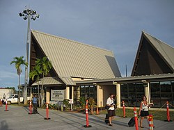
Yap International Airport receives service from United Airlines as well as Pacific Mission Aviation. The state also has a small dockyard, colloquially known as Gampek, in Colonia just south of Tamil Harbor that services maritime vessels for inter-state and cross-border transport and freight.

Education

Post-secondary institutions:

State secondary schools: [26]

Private Secondary and Elementary Schools:

Notable people

See also

Related Research Articles

<span class="mw-page-title-main">Federated States of Micronesia</span> Country in Oceania

The Federated States of Micronesia, or simply Micronesia, is an island country in Micronesia, a subregion of Oceania. The federation consists of four states—from west to east, Yap, Chuuk, Pohnpei and Kosrae—that are spread across the western Pacific. Together, the states comprise around 607 islands that cover a longitudinal distance of almost 2,700 km (1,700 mi) just north of the equator. They lie northeast of Indonesia and Papua New Guinea, south of Guam and the Marianas, west of Nauru and the Marshall Islands, east of Palau and the Philippines, about 2,900 km (1,800 mi) north of eastern Australia, 3,400 km (2,100 mi) southeast of Japan, and some 4,000 km (2,485 mi) southwest of the main islands of the Hawaiian Islands.

<span class="mw-page-title-main">History of the Federated States of Micronesia</span> Historical development of the Federated States of Micronesia

The Federated States of Micronesia are located on the Caroline Islands in the western Pacific Ocean. The history of the modern Federated States of Micronesia is one of settlement by Micronesians; colonization by Spain, Germany, and Japan; United Nations trusteeship under United States-administered Trust Territory of the Pacific Islands; and gradual independence beginning with the ratification of a sovereign constitution in 1979.

<span class="mw-page-title-main">Geography of the Federated States of Micronesia</span>

Geography of the Federated States of Micronesia (FSM), a country located in the western Pacific Ocean, and in the Micronesia cultural and ecological sub-region of Oceania. While its total land area is very small at 702 km2 (271 sq mi), it has the 14th largest exclusive economic zone at 2,996,419 km2 (1,156,924 sq mi).

<span class="mw-page-title-main">Demographics of the Federated States of Micronesia</span>

Demographic features of the population of the Federated States of Micronesia include population density, ethnicity, education level, health of the populace, economic status, religious affiliations and other aspects. The indigenous population of the Federated States of Micronesia, which is predominantly Micronesian, consists of various ethnolinguistic groups. English has become the common language. Population growth remains high at more than 3%, but is ameliorated somewhat by net emigration.

<span class="mw-page-title-main">Micronesia</span> Subregion of Oceania

Micronesia is a subregion of Oceania, consisting of about 2,000 small islands in the Northwestern Pacific Ocean. It has a close shared cultural history with three other island regions: Maritime Southeast Asia to the west, Polynesia to the east, and Melanesia to the south—as well as with the wider community of Austronesian peoples.

<span class="mw-page-title-main">Trust Territory of the Pacific Islands</span> US-administered UN trust territory (1947–1994)

The Trust Territory of the Pacific Islands (TTPI) was a United Nations trust territory in Micronesia administered by the United States from 1947 to 1994. The Imperial Japanese South Seas Mandate had been seized by the US during the Pacific War, as Japan had administered the territory since the League of Nations gave Japan mandate over the area from Imperial Germany after World War I. However, in the 1930s, Japan left the League of Nations, and then invaded additional lands. During World War II, military control of the islands was disputed, but by the end of the war the islands had come under control of the Allies. The Trust Territory of the Pacific was created to administer the islands as part of the United States, while still under the auspices of the United Nations. Most of the island groups in the territory became independent states, with some degree of ties kept with the United States: the Federated States of Micronesia, Marshall Islands and Palau are today independent states in a Compact of Free Association with the US, while the Northern Mariana Islands remain under US jurisdiction, as an unincorporated territory and commonwealth.

<span class="mw-page-title-main">Pohnpei</span> Island in Micronesia

Pohnpei is an island of the Senyavin Islands which are part of the larger Caroline Islands group. It belongs to Pohnpei State, one of the four states in the Federated States of Micronesia (FSM). Major population centers on Pohnpei include Palikir, the FSM's capital, and Kolonia, the capital of Pohnpei State. Pohnpei is the largest island in the FSM, with an area of 334 km2 (129 sq mi), and a highest point of 782 m (2,566 ft), the most populous with 36,832 people, and the most developed single island in the FSM.

<span class="mw-page-title-main">Palikir</span> Capital city of the Federated States of Micronesia

Palikir is the capital city of the Federated States of Micronesia located in the western Pacific Ocean. A town of slightly under 5,000 residents, it is part of the larger Sokehs municipality, which had a population of 6,647 as of 2010, out of the nation's total population of 106,487. It is situated on the northwest side of Pohnpei island, a high volcanic island surrounded by a fringing coral reef. Nearby to the northeast is the island's largest settlement, the coastal town of Kolonia. It was declared the capital of Micronesia in 1989.

<span class="mw-page-title-main">Chuuk State</span> State in the Federated States of Micronesia

Chuuk State is one of the four states of the Federated States of Micronesia (FSM). The other states are Kosrae State, Pohnpei State, and Yap State. It consists of several island groups: Namoneas, Faichuuk, the Hall Islands, Namonuito Atoll, Pattiw, and the Mortlock Islands. Chuuk is by far the FSM's most populous state, with 50,000 inhabitants on 120 square kilometers. Chuuk Lagoon is where most people live. Weno island, in the lagoon, is Chuuk's state capital and the country's biggest city. It may hold a referendum on independence in the near future, although this referendum has been repeatedly postponed.

<span class="mw-page-title-main">FSM National Police</span>

The Federated States of Micronesia's National Police is the small national police force of the Federated States of Micronesia and is a division of the FSM Department of Justice.

Micronesian Americans are Americans who are descended from people of the Federated States of Micronesia. According to the 2020 US Census, a total of 21,596 residents self-identified as having origins in the country, which consists of four states. More than half of these residents identified their origin as Chuuk State (12,464) with the rest as follows: 4,918 people from Pohnpei, 2,066 from Yap, and 2,148 people from Kosrae.

<span class="mw-page-title-main">Japanese Micronesians</span> Micronesians of Japanese descent

Japanese Micronesians, also Nikkei Micronesians or Micronesians of Japanese descent, refers to citizens of the Federated States of Micronesia (FSM) who are of Japanese descent and are members of the Japanese global diaspora known as the Nikkei (日系).

<span class="mw-page-title-main">Typhoon Sudal</span> Pacific typhoon in 2004

Typhoon Sudal, known in the Philippines as Typhoon Cosme, was the strongest typhoon to strike the island of Yap in the Federated States of Micronesia (FSM) in about 50 years. Yap is one of the four administrative divisions of the FSM. The entire island, only 17 km (11 mi) in length, experienced typhoon force winds, and 90% of the structures were damaged or destroyed. Damage was most severe in southeastern Yap, where the eyewall struck and winds exceeded 185 km/h (115 mph), but the center of the typhoon passed south of the island.

<span class="mw-page-title-main">Gagil</span> Municipality in Yap, Federated States of Micronesia

Gagil is a municipality in the state of Yap. It forms part of Gagil-Tamil Island and covers the eastern side of the island. It has a population of roughly 400 people scattered in village groups. One of these villages includes the village of Gachpar which was once the capital of the historic Yap Islands Empire that lasted from about 10th to the 15th century AD and stretched as far as east as the west halls of Chuuk Lagoon, as far south as the northern atolls of Papua New Guinea, and as far west as the outer islands of Palau. The Yap Islands Empire centered in Gagil and it, and the Tui Tonga Empire of Tonga, are the only empires that existed in the ancient history of the Pacific Islands.

<span class="mw-page-title-main">Yapese people</span> Ethnic group

The Yapese people are a Micronesian ethnic group native to the main island of Yap. Yapese culture is built on the maxim: Respect and Responsibility. Aspects of traditional Yapese culture are still important in modern Yapese culture.

<span class="mw-page-title-main">Health in the Federated States of Micronesia</span>

The Human Rights Measurement Initiative finds that the Federated States of Micronesia are fulfilling 94.9% of what it should be fulfilling for the right to health based on its level of income. When looking at the right to health with respect to children, the Federated States of Micronesia achieve 97.1% of what is expected based on their current income. In regards to the right to health amongst the adult population, the country achieves only 91.9% of what is expected based on the nation's level of income. The Federated States of Micronesia fall into the "good" category when evaluating the right to reproductive health because the nation is fulfilling only 95.8% of what the nation is expected to achieve based on the resources (income) it has available.

<span class="mw-page-title-main">2019 Micronesian parliamentary election</span>

Parliamentary elections were held in the Federated States of Micronesia on 5 March 2019, alongside a referendum on calling a Constitutional Convention. All 14 seats in Congress were up for election, and all 13 incumbents standing for re-election were returned to Congress.

<span class="mw-page-title-main">The Church of Jesus Christ of Latter-day Saints in the Federated States of Micronesia</span> Regional presence of The Church of Jesus Christ of Latter-day Saints

The Church of Jesus Christ of Latter-day Saints in the Federated States of Micronesia refers to the Church of Jesus Christ of Latter-day Saints and its members in the Federated States of Micronesia (FSM). The church's first known missionaries arrived on July 5, 1978. As of December 31, 2022, there were 5,966 members in 23 congregations in FSM. The LDS Church has congregations in every state in the FSM.

The traditional councils of the Yap State are two assemblies of traditional leaders: the Pilung Council for the chiefs of the Yap Islands and the Tamol Council for the chiefs of the Outer Yap Islands. They have been established in 1992 by the Constitution of the Yap State, within the Federated States of Micronesia. The executive, the legislative, the judiciary and the traditional councils are the four institutional branches of government in the Yap State, but the councils, unlike the others, transcend the concept of the separation of powers. The councils are responsible for exercising the functions that relate to tradition and custom, which are not required to be recorded in the written law. In the Yap State, custom and tradition prevail over any interpretation of the constitution and even over any judicial decision. The councils have the right to veto legislation that they consider to be contrary to traditional practices. The constitutionality of these councils and their veto power could be challenged under the Micronesian Federal Constitutional Law, but to this date no one has done it.

<span class="mw-page-title-main">2023 Micronesian constitutional referendum</span> Referendum on proposed amendments to the constitution of Micronesia

A referendum on nine proposed amendments to the constitution was held in Micronesia on 4 July 2023. Eight of the amendments were proposed by the Constitutional Convention elected in 2019, and one amendment was proposed by Congress. All nine amendments passed, and were officially ratified by President Simina on 4 October 2023.

References

  1. Petersen, G. (2000). Indigenous Island Empires: Yap and Tonga Considered. The Journal of Pacific History, 35(1), 8-9. http://www.jstor.org/stable/25169463.
  2. "Population Statistics – FSM Statistics". Archived from the original on 2021-04-21. Retrieved 2021-06-06.
  3. 1 2 3 "Yap Islands | archipelago, Micronesia | Britannica". www.britannica.com. Retrieved 2023-03-01.
  4. "The History of Yap Island from 1500 B.C. to Present". www.visityap.com. 17 November 2014. Retrieved 2023-03-01.
  5. PacificWrecks.com. "Pacific Wrecks". pacificwrecks.com. Retrieved 2023-03-01.
  6. "Yap Island". www.u-s-history.com. Retrieved 2023-03-01.
  7. Kleiber, Eleanor. "Research Guides: Trust Territory of the Pacific Islands Archives: Introduction". guides.library.manoa.hawaii.edu. Retrieved 2023-03-01.
  8. "Micronesia's constitution – 1975" (PDF).
  9. 1 2 "Yap – Legal Information System of the Federated States of Micronesia". fsmlaw.org. Archived from the original on 2021-04-21. Retrieved 2021-05-29.
  10. "Yap, Federated States of Micronesia". Pacific Resources for Education and Learning. Archived from the original on 2006-10-14. Retrieved 2006-10-24.
  11. "Population Statistics – FSM Statistics". Archived from the original on 2021-04-21. Retrieved 2021-05-29.
  12. "International Religious Freedom Report for 2018" (PDF). US Department of State . Archived (PDF) from the original on 22 March 2021. Retrieved 7 June 2021.
  13. "Census 1987 with village population figures" (PDF). Archived (PDF) from the original on 2016-03-27. Retrieved 2012-06-17.
  14. "2010 Census Basic Table – Yap". Archived from the original on 2021-09-12. Retrieved 2022-03-01.
  15. Includes Olimarao Atoll.
  16. Includes Gaferut Atoll/Fayo.
  17. Includes Piagailoe Atoll/West Fayu.
  18. "Weatherbase: Historical Weather for Yap, Federated States of Micronesia". Weatherbase. Archived from the original on 6 November 2018. Retrieved 13 December 2012.
  19. "Climatological Information for Yap, Pacific Islands, United States". Hong Kong Observatory. Archived from the original on 3 March 2016. Retrieved 13 December 2012.
  20. McKinlay, Glenn (August 2019). "Federated States of Micronesia Fiscal Year 2018 Statistical Appendices" (PDF). The Pacific Islands Training Initiative (PITI-VITI). Archived (PDF) from the original on 2022-06-05. Retrieved 2022-06-04.
  21. "Labour Market Statistics detailed". FSM Statistics Office . Archived from the original on 26 April 2021. Retrieved 6 June 2021.
  22. 1 2 Lin, Daniel (15 August 2017). "This Pacific Island Is Caught in a Global Power Struggle (And It's Not Guam)". 'National Geographic'. Archived from the original on 20 June 2018. Retrieved 16 September 2019.
  23. "Bank of Guam". Archived from the original on 2022-02-17. Retrieved 2022-03-01.
  24. "FSM Development Bank". Archived from the original on 2022-02-05. Retrieved 2022-03-01.
  25. McClure, Joyce (2021-03-10). "The little island that could: Yap takes the lead in digital communications for FSM". pactimes. Archived from the original on 2021-06-06. Retrieved 2021-06-06.
  26. "Higher Education in the Federated States of Micronesia". Embassy of the Federated States of Micronesia Washington DC. Archived from the original on 2017-10-14. Retrieved 23 February 2018.
  27. "ABOUT YCHS". Yap Catholic High School. Archived from the original on 2018-06-20. Retrieved 22 February 2018.