History of the Federated States of Micronesia

Last updated
A map of the Federated States of Micronesia. Map of the Federated States of Micronesia CIA.jpg
A map of the Federated States of Micronesia.

The Federated States of Micronesia are located on the Caroline Islands in the western Pacific Ocean. The history of the modern Federated States of Micronesia is one of settlement by Micronesians; colonization by Spain, Germany, and Japan; United Nations trusteeship under United States-administered Trust Territory of the Pacific Islands; and gradual independence beginning with the ratification of a sovereign constitution in 1979.

Contents

Pre-colonial history

The Austronesian ancestors of the Micronesians settled there over 4,000 years ago. A decentralized chieftain-based system eventually evolved into a more centralized economic and religious culture centered on Pohnpei. [1] People from the Caroline Islands had regular contact with the Chamorro people of the Marianas Islands, as well as rarer voyages into the eastern islands of the Philippines. [2]

Yap and the Yapese Empire

Yapese Empire

From circa 1500 BC, before the beginning of foreign colonial administration by Western powers, the island of Yap created and maintained a unique set of socio-economic and political relationships with neighbouring islands to its east and southwest in what is known as the Yapese Empire. [3] Although small-scale and informal, the Empire per se was formed when what is now known as Gagil Municipality through the chief village of Gatchaper, developed and maintained a maritime trade and political network with smaller atolls and island groups between Yap and Chuuk, covering over approximately 1,500 kilometres (932.01 miles) of the western Pacific.

Village assembly hall, also known as pe'ebaey, at Yap Island in 1932. Assembly house at Yap island in 1932.png
Village assembly hall, also known as pe'ebaey, at Yap Island in 1932.

Through a relationship known as sawey, the Empire demanded tribute known as Pitigil Tamol to be given to the paramount chief of Gagil in Gatchaper. [4] These tributes would include bagiiy (lavalava), coconut rope, coconut oil, mats and shells. In return, Gagil would reciprocate with mutual support from the main island in case of natural emergencies as well as goods. These goods from Gagil would include Yapese canoes, turmeric, flint stone and other Yapese resources. [4] The relationship also asked those with navigational experience and expertise for service along with Yapese navigators. This relationship may have helped the Yapese sail to Palau for quarrying the Rai stones, the stone currency disks carved from crystalline calcite still used today in cultural transactions.

Traditional Yapese canoe, or muw'. Canoe at Yap island in 1932.png
Traditional Yapese canoe, or muw'.

Although this unique relationship with Gagil and the outer islands may appear exploitative, researchers such as Lessa (1950, pp. 43, 52; 1986, p. 35) and Lingenfelter (p. 147) maintain that the relationship was mostly mutual and, in most cases, was more beneficial to the Carolinians than to the Yapese. Lessa (1950, p. 70-71) had also suggested that the so-called empire was formed out of conquest and "blackmail" through sorcery and economics.

Other places mentioned in Pacific anthropological-historical literature that were quite similar to the Yapese Empire was the Tongan Empire, also known as Tu'i Tonga, which is now present-day Kingdom of Tonga.

Yapese traditional society: feudalism and the social caste system

Yapese traditional society before foreign colonial administrations was divided into multiple villages and municipalities and is highly feudal in nature. Power was not allocated to one single authority that controlled Yap but was decentralised and allocated to at least ten municipalities. A defining feature of Yapese society was its unique and complex social caste system, which is still in use today. Each of the current one-hundred twenty-nine (129) villages of Yap are organised into single units based on the class system depicted below. [5]

HIGH CLASSES: TABUGUL ("PURE")
CLASSES/CASTES
Bulche'/ 'UlunChiefs
Methibaan/TethibaanNobles
DaworchigCommoners
Detailed Map of the Municipalities of Yap Island Yap Islands municipalities.jpg
Detailed Map of the Municipalities of Yap Island
LOW CLASSES: TA'AY ("IMPURE")
CLASSES/CASTES
Milingaay ni 'ArowServants
MilingaaySerfs
Yagug/Milignaay ni KaanSerfs

Although each village has its own class ranking within the municipality based on the number of military victories, each village also has its own internal set of social classes exclusive to that group. All low classes and low-class villages were under the authority of villages that were ranked higher since the latter had considerable power and voice (lungun). [5] An example of a high-ranking village is the aforementioned Gatchaper, which is ranked Bulche' or 'UIun. Because villages and municipalities were continuously at war amongst one another, village and personal social ranks fluctuated based on military outcomes.

However, in the 20th century, during the German occupation of Yap, the German administration pacified the island and enforced strict prohibition against violent conflicts. This policy resulted in a permanent freeze of all social caste rankings. Today, there are three villages with the high-ranking chief villages: Teb Village in Tamil Municipality, Ngolog Village in Rull Municipality and Gatchaper in Gagil Municipality.

These chief villages and their municipalities are referred to in Yapese as "fare dalip e nguchol", which means "the three cooking stones". This similarity was created to describe the relationship between these three villages and municipalities with the other remaining seven. The stones, or nguchol, represent Tamil, Gagil and Rull while the pot represents the island of Yap. The saying goes that when one stone, or one municipality or village, fell, all of Yap and its value would fall as well.

Pohnpei and Saudeleur rule

Pohnpei map.gif
Municipality map of modern Pohnpei; under Saudeleur rule, there were only three first-level divisions
Map FM-Nan Madol.PNG
Central Nan Madol

On Pohnpei, pre-colonial history is divided into three eras: Mwehin Kawa or Mwehin Aramas (Period of Building, or Period of Peopling, before c. 1100); Mwehin Sau Deleur (Period of the Lord of Deleur, c. 1100 [6] to c. 1628); [note 1] and Mwehin Nahnmwarki (Period of the Nahnmwarki, c. 1628 to c. 1885). [7] [10] Pohnpeian legend recounts that the Saudeleur rulers, the first to bring government to Pohnpei, were of foreign origin. The Saudeleur centralized form of absolute rule is characterized in Pohnpeian legend as becoming increasingly oppressive over several generations. Arbitrary and onerous demands, as well as a reputation for offending Pohnpeian deities, sowed resentment among Pohnpeians. The Saudeleur Dynasty ended with the invasion of Isokelekel, another semi-mythical foreigner, who replaced the Saudeleur rule with the more decentralized nahnmwarki system in existence today. [12] [13] [14] Isokelekel is regarded as the creator of the modern Pohnpeian nahnmwarki social system and the father of the Pohnpeian people. [12] [15]

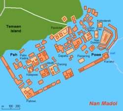
Nan Madol offshore of Temwen Island near Pohnpei, consists of a series of small artificial islands linked by a network of canals, and is often called the Venice of the Pacific. It is located near the island of Pohnpei and was the ceremonial and political seat of the Saudeleur Dynasty that united Pohnpei's estimated 25,000 people until its centralized system collapsed amid the invasion of Isokelekel. [14] Isokelekel and his descendants initially occupied the stone city, but later abandoned it. [10]

European colonisation

Manila Galleon in the Marianas and Carolinas, c. 1590 Boxer Codex Reception of the Manila Galleon by the Chamorro in the Ladrones Islands, ca. 1590.jpg
Manila Galleon in the Marianas and Carolinas, c. 1590 Boxer Codex

European explorers - first the Portuguese in search of the Spice Islands (Indonesia) and then the Spanish - reached the Carolines in the 16th century, with the Spanish establishing sovereignty. [1]

Spain sold the islands to Germany in 1899 under the terms of the German–Spanish Treaty of that year. [1] Germany placed them under the jurisdiction of German New Guinea. German efforts to reorganize the traditional social hierarchy and recruit forced labor for construction resulted in a rebellion by inhabitants of Sokehs Municipality in 1910.

Yap was a major German naval communications center before the First World War and an important international hub for cable telegraphy. It was occupied by Japanese troops in September, 1914, and passed to the Japanese Empire under the Versailles Treaty in 1919 as a mandated territory under League of Nations supervision. US commercial rights on the island were secured by a special US-Japanese treaty to that effect, concluded on February 11, 1922. [16]

Empire of Japan

Making Dried bonito at Chuuk in 1931.png Making Dried bonito at Chuuk, Micronesia in 1931.png
Making Dried bonito at Chuuk in 1931.png

During World War I, many of the German possessions in the Pacific were conquered by Japan, who fought on the side of the Allies of World War I and was active in the Asian and Pacific theatre of World War I.

The Empire of Japan administered the islands from 1920 under the South Seas Mandate granted by the League of Nations. During this period, the Japanese population grew to over 100,000 throughout Micronesia, while the indigenous population was about 40,000. Sugar cane, mining, fishing and tropical agriculture became the major industries. [17]

World War II

In World War II, Japanese-held Yap was one of the islands bypassed in the U.S. "leapfrogging" strategy, although it was regularly bombed by U.S. ships and aircraft, and Yap-based Japanese bombers did some damage in return. The Japanese garrison comprised 4,423 Imperial Japanese Army men under the command of Colonel Daihachi Itoh and 1,494 Imperial Japanese Navy men. [18] A significant portion of the Japanese fleet was based in Truk Lagoon. In February 1944, Operation Hailstone, one of the most important naval battles of the war, took place at Truk, in which many Japanese support vessels and aircraft were destroyed.

World War II brought an abrupt end to the relative prosperity experienced during Japanese civil administration. [19]

Trusteeship

Flag of the Trust Territory of the Pacific Islands; was used in the FSM 1965 to 1978. Flag of the Trust Territory of the Pacific Islands.svg
FIAV historical.svg Flag of the Trust Territory of the Pacific Islands; was used in the FSM 1965 to 1978.

The United Nations created the Trust Territory of the Pacific Islands (TTPI) in 1947. Pohnpei (then including Kusaie), Truk, Yap, Palau, the Marshall Islands and the Northern Mariana Islands, together constituted the TTPI. The United States accepted the role of Trustee of this, the only United Nations Trusteeship to be designated as a "Security Trusteeship", whose ultimate disposition was to be determined by the UN Security Council. [1] As Trustee the US was to "promote the economic advancement and self-sufficiency of the inhabitants."

Independence

Tosiwo Nakayama, first president of the Federated States of Micronesia Tosiwonakayama.jpg
Tosiwo Nakayama, first president of the Federated States of Micronesia

On May 10, 1979, four of the Trust Territory districts ratified the Constitution of the Federated States of Micronesia. The neighboring trust districts of Palau, the Marshall Islands, and the Northern Mariana Islands chose not to participate. The Honorable Tosiwo Nakayama, the former President of the Congress of Micronesia, became the first President of the FSM and formed his Cabinet. The FSM signed a Compact of Free Association with the U.S., which entered into force on November 3, 1986, marking Micronesia's emergence from trusteeship to independence. Under the Compact, the U.S. has full authority and responsibility for the defense of the FSM. This security relationship can be changed or terminated by mutual agreement. The Compact provides U.S. grant funds and federal program assistance to the FSM. Amended financial assistance provisions came on-line in FY 2004. The basic relationship of free association continues indefinitely.

Trusteeship of the islands ended under United Nations Security Council Resolution 683, passed on December 22, 1990. The Compact was renewed in 2004. [20]

See also

Notes

  1. The Saudeleur era lasted around 500 years. [7] Legend generally dates their downfall to the 1500s, [8] however archaeologists date Saudeleur ruins to c. 1628. [9] [10] [11]
  1. 1 2 3 4 "Background Note: Micronesia". United States Department of State. Retrieved 2012-01-06.
  2. Peterson, John A. (2012). "Latte villages in Guam and the Marianas: Monumentality or monumenterity?" (PDF). Micronesica. 42 (1/2): 183–208. Archived (PDF) from the original on 2017-08-20.
  3. "The History of Yap Island from 1500 B.C. to Present". www.visityap.com. Retrieved 2021-05-28.
  4. 1 2 Petersen, Glenn (2000). "Indigenous Island Empires: Yap and Tonga Considered". The Journal of Pacific History. 35 (1): 5–27. ISSN   0022-3344. JSTOR   25169463.
  5. 1 2 Marksbury, Richard A. (1982). "Legislating Social Order: An Example from the Yap Islands". Oceania. 53 (1): 19–28. ISSN   0029-8077. JSTOR   40332266.
  6. Flood, Bo; Strong, Beret E.; Flood, William (2002). Micronesian Legends. Bess Press. pp. 145–7, 160. ISBN   1-57306-129-8 . Retrieved 2012-01-01.
  7. 1 2 Hanlon, David L (1988). Upon a Stone Altar: A History of the Island of Pohnpei to 1890. Pacific Islands Monograph. Vol. 5. University of Hawaii Press. pp. 13–25. ISBN   0-8248-1124-0 . Retrieved 2012-01-01.
  8. Cordy, Ross H (1993). The Lelu Stone Ruins (Kosrae, Micronesia): 1978-81 Historical and Archaeological Research. Asian and Pacific Archaeology. Social Science Research Institute, University of Hawaii at Manoa. pp. 14, 254, 258. ISBN   0-8248-1134-8 . Retrieved 2011-12-31.
  9. Morgan, William N (1988). Prehistoric Architecture in Micronesia. University of Texas Press. pp. 60, 63, 76, 85. ISBN   0-292-76506-1 . Retrieved 2011-12-31.
  10. 1 2 3 Panholzer, Tom; Rufino, Mauricio (2003). Place Names of Pohnpei Island: Including And (Ant) and Pakin Atolls. Bess Press. pp. xiii, xii, 101. ISBN   1-57306-166-2 . Retrieved 2011-12-31.
  11. Micronesica. University of Guam. 1990. pp. 92, 203, 277. Retrieved 2011-12-31.
  12. 1 2 Ballinger, Bill Sanborn (1978). Lost City of Stone: The Story of Nan Madol, the "Atlantis" of the Pacific. Simon and Schuster. pp. 45–8. ISBN   0-671-24030-7 . Retrieved 2011-12-31.
  13. Riesenberg, Saul H (1968). The Native Polity of Ponape. Contributions to Anthropology. Vol. 10. Smithsonian Institution Press. pp. 38, 51. ISBN   978-0-598-44243-7 . Retrieved 2012-01-01.
  14. 1 2 Petersen, Glenn (1990). "Lost in the Weeds: Theme and Variation in Pohnpei Political Mythology" (PDF). Occasional Papers. Center for Pacific Islands Studies, School of Hawaiian, Asian & Pacific Studies, University of Hawaiʻi at Mānoa. 35: 34 et seq. Archived (PDF) from the original on 2012-01-27. Retrieved 2011-12-31.
  15. Goetzfridt, Nicholas J; Peacock, Karen M (2002). Micronesian Histories: An Analytical Bibliography and Guide to Interpretations. Bibliographies and Indexes in World History. Greenwood Publishing Group. pp. 3, 34–5, 102, 156–9. ISBN   0-313-29103-9 . Retrieved 2011-12-31.
  16. Text in League of Nations Treaty Series, vol. 12, pp. 202-211.
  17. Arnold, Bruce Makoto (2011). "Conflicted Childhoods in the South Seas: The Failure of Racial Assiimilation in the Nan'yo". Tufts Historical Review. 4 (11): 79–96.
  18. Takizawa, Akira; Alsleben, Allan (1999–2000). "Japanese garrisons on the by-passed Pacific Islands 1944-1945". Forgotten Campaign: The Dutch East Indies Campaign 1941-1942. Archived from the original on 2016-01-06.
  19. Sugihara, Kaoru (1997). "The Economic Motivations behind Japanese Aggression in the Late 1930s: Perspectives of Freda Utley and Nawa Toichi". Journal of Contemporary History. 32 (2): 259–280. ISSN   0022-0094. JSTOR   261244.
  20. "Compact of Free Association". Archived from the original on 26 January 2016. Retrieved 2 January 2016.

Related Research Articles

<span class="mw-page-title-main">Federated States of Micronesia</span> Country in Oceania

The Federated States of Micronesia, or simply Micronesia, is an island country in Micronesia, a subregion of Oceania. The federation consists of four states—from west to east, Yap, Chuuk, Pohnpei and Kosrae—that are spread across the western Pacific. Together, the states comprise around 607 islands that cover a longitudinal distance of almost 2,700 km (1,700 mi) just north of the equator. They lie northeast of Indonesia and Papua New Guinea, south of Guam and the Marianas, west of Nauru and the Marshall Islands, east of Palau and the Philippines, about 2,900 km (1,800 mi) north of eastern Australia, 3,400 km (2,100 mi) southeast of Japan, and some 4,000 km (2,485 mi) southwest of the main islands of the Hawaiian Islands.

<span class="mw-page-title-main">Micronesia</span> Subregion of Oceania

Micronesia is a subregion of Oceania, consisting of about 2,000 small islands in the Northwestern Pacific Ocean. It has a close shared cultural history with three other island regions: Maritime Southeast Asia to the west, Polynesia to the east, and Melanesia to the south—as well as with the wider community of Austronesian peoples.

<span class="mw-page-title-main">Trust Territory of the Pacific Islands</span> US-administered UN trust territory (1947–1994)

The Trust Territory of the Pacific Islands (TTPI) was a United Nations trust territory in Micronesia administered by the United States from 1947 to 1994. The Imperial Japanese South Seas Mandate had been seized by the US during the Pacific War, as Japan had occupied the territory since the League of Nations gave Japan mandate over the area after World War I. However, in the 1930s, Japan left the League of Nations, and then invaded additional lands. During World War II, military control of the islands was disputed, but by the end of the war the islands had come under control of the Allies. The Trust Territory of the Pacific was created to administer the islands as part of the United States, while still under the auspices of the United Nations. Most of the island groups in the territory became independent states, with some degree of ties kept with the United States: the Federated States of Micronesia, Marshall Islands and Palau are today independent states in a Compact of Free Association with the US, while the Northern Mariana Islands remain under US jurisdiction, as an unincorporated territory and commonwealth.

<span class="mw-page-title-main">Pohnpei</span> Island in Micronesia

Pohnpei is an island of the Senyavin Islands which are part of the larger Caroline Islands group. It belongs to Pohnpei State, one of the four states in the Federated States of Micronesia (FSM). Major population centers on Pohnpei include Palikir, the FSM's capital, and Kolonia, the capital of Pohnpei State. Pohnpei is the largest island in the FSM, with an area of 334 km2 (129 sq mi), and a highest point of 782 m (2,566 ft), the most populous with 36,832 people, and the most developed single island in the FSM.

<span class="mw-page-title-main">Palikir</span> Capital city of the Federated States of Micronesia

Palikir is the capital city of the Federated States of Micronesia located in the western Pacific Ocean. A town of slightly under 5,000 residents, it is part of the larger Sokehs municipality, which had a population of 6,647 as of 2010, out of the nation's total population of 106,487. It is situated on the northwest side of Pohnpei island, a high volcanic island surrounded by a fringing coral reef. Nearby to the northeast is the island's largest settlement, the coastal town of Kolonia. It was declared the capital of Micronesia in 1989.

<span class="mw-page-title-main">Caroline Islands</span> Archipelago in the western Pacific Ocean, part of Micronesia and Palau

The Caroline Islands are a widely scattered archipelago of tiny islands in the western Pacific Ocean, to the north of New Guinea. Politically, they are divided between the Federated States of Micronesia (FSM) in the central and eastern parts of the group, and Palau at the extreme western end. Historically, this area was also called Nuevas Filipinas or New Philippines, because they were part of the Spanish East Indies and were governed from Manila in the Philippines.

<span class="mw-page-title-main">Chuuk State</span> State in Federated States of Micronesia

Chuuk State is one of the four states of the Federated States of Micronesia (FSM). The other states are Kosrae State, Pohnpei State, and Yap State. It consists of several island groups: Namoneas, Faichuuk, the Hall Islands, Namonuito Atoll, Pattiw, and the Mortlock Islands. Chuuk is by far the FSM's most populous state, with 50,000 inhabitants on 120 square kilometers. Chuuk Lagoon is where most people live. Weno island, in the lagoon, is Chuuk's state capital and the country's biggest city. It may hold a referendum on independence in the near future, although this referendum has been repeatedly postponed.

<span class="mw-page-title-main">Yap State</span> Constituent state of the Federation of Micronesia

Yap State is one of the four states of the Federated States of Micronesia (FSM). The other states are Kosrae State, Pohnpei State, and Chuuk State.

<span class="mw-page-title-main">Saudeleur dynasty</span> First organized government uniting the people of Pohnpei island

The Saudeleur dynasty was the first organized government uniting the people of Pohnpei island, ruling from c. 1100-1200 CE to c. 1628 CE. The era was preceded by the Mwehin Kawa or Mwehin Aramas, and followed by Mwehin Nahnmwarki. The name Deleur was an ancient name for Pohnpei, today a state containing the capital of the Federated States of Micronesia.

Micronesian mythology comprises the traditional belief systems of the people of Micronesia. There is no single belief system in the islands of Micronesia, as each island region has its own mythological beings.

<span class="mw-page-title-main">Kolonia</span> Place in Pohnpei, Federated States of Micronesia

Kolonia is a coastal town and the capital of Pohnpei State in the Federated States of Micronesia (FSM). It's not to be confused with the far smaller Colonia, the capital of the State of Yap. It was also the former FSM capital before being replaced by Palikir in 1989, located nearby to the southwest in the municipality of Sokehs. It has 6,074 people.

The Pingelapese language is a Micronesian language native to Pingelap, an atoll belonging to the state of Pohnpei in the Federated States of Micronesia. This atoll is the homeland to the Pingelapese people, consisting of a three-square mile range of uninhabited small coral islets, Daekae and Sukora, and the inhabited islet, Pingelap. These islands partially make up the Caroline Islands.

<span class="mw-page-title-main">College of Micronesia-FSM</span> Public community college in Micronesia

The College of Micronesia-FSM (COM-FSM) is a public community college in the Federated States of Micronesia. It began operation in 1963 as the Micronesian Teacher Education Center.

Micronesian Americans are Americans who are descended from people of the Federated States of Micronesia. According to the 2010 census, a total of 8,185 residents self-identified as having origins in the country, which consists of four states. More than half of these residents identified their origin as Chuuk State (4,211) with the rest as follows: 2,060 people from Pohnpei, 1,018 from Yap, and 906 people from Kosrae.

<span class="mw-page-title-main">Yap</span> Island group in the Federated States of Micronesia

Yap traditionally refers to an island group located in the Caroline Islands of the western Pacific Ocean, a part of Yap State. The name "Yap" in recent years has come to also refer to the state within the Federated States of Micronesia, inclusive of the Yap Main Islands and its various outer islands, the Yap Neighboring Islands. For specifying the island group, the name Yap Main Islands is most exact.

<span class="mw-page-title-main">Japanese Micronesians</span> Micronesians of Japanese descent

Japanese Micronesians, also Nikkei Micronesians or Micronesians of Japanese descent, refers to citizens of the Federated States of Micronesia (FSM) who are of Japanese descent and are members of the Japanese global diaspora known as the Nikkei (日系).

Isokelekel, also called Idzikolkol, was a semi-mythical hero warrior from Kosrae who conquered the Saudeleur Dynasty of Pohnpei, an island in the modern Federated States of Micronesia, sometime between the early 16th century and early 17th century. Some Kosraean variants name this hero Nanparatak, with features closer to Ulithian tales of the same archetype. He is considered the father of modern Pohnpei.

The nationality law of the Federated States of Micronesia determines who is or may become a citizen or national of the Federated States of Micronesia (FSM). Article III of the Constitution of the Federated States of Micronesia provides the basis for nationality law, while specific provisions are elaborated in 7 FSMC § 201 et seq.

<span class="mw-page-title-main">Yapese people</span> Ethnic group

The Yapese people are a Micronesian ethnic group native to the main island of Yap. Yapese culture is built on the maxim: Respect and Responsibility. Aspects of traditional Yapese culture are still important in modern Yapese culture.

<span class="mw-page-title-main">The Church of Jesus Christ of Latter-day Saints in the Federated States of Micronesia</span> Regional presence of The Church of Jesus Christ of Latter-day Saints

The Church of Jesus Christ of Latter-day Saints in the Federated States of Micronesia refers to the Church of Jesus Christ of Latter-day Saints and its members in the Federated States of Micronesia (FSM). The church's first known missionaries arrived on July 5, 1978. As of December 31, 2022, there were 5,966 members in 23 congregations in FSM. The LDS Church has congregations in every state in the FSM.

References