1993 Pacific typhoon season

Last updated
1993 Pacific typhoon season
1993 Pacific typhoon season summary.jpg
Season summary map
Seasonal boundaries
First system formedFebruary 28, 1993
Last system dissipatedJanuary 1, 1994
Strongest storm
Name Koryn
  Maximum winds195 km/h (120 mph)
(10-minute sustained)
  Lowest pressure905 hPa (mbar)
Seasonal statistics
Total depressions50
Total storms28
Typhoons15
Super typhoons3 (unofficial)
Total fatalities>758
Total damage> $2.8 billion (1993 USD)
Related articles
Pacific typhoon seasons
1991, 1992, 1993, 1994, 1995

The 1993 Pacific typhoon season was the most active season for the Philippines, seeing a total of 32 storms forming or entering their area of responsibility. Overall, it was an average season, spawning 28 tropical storms, 15 typhoons and three super typhoons. The season had no official bounds; it ran year-round in 1993, but most tropical cyclones tend to form in the northwestern Pacific Ocean between May and November. [1] These dates conventionally delimit the period of each year when most tropical cyclones form in the northwestern Pacific Ocean.

Contents

Tropical Storms formed in the entire west pacific basin were assigned a name by the Joint Typhoon Warning Center. Tropical depressions in this basin have the "W" suffix added to their number. Tropical depressions that enter or form in the Philippine area of responsibility are assigned a name by the Philippine Atmospheric, Geophysical and Astronomical Services Administration or PAGASA. This can often result in the same storm having two names.

Season summary

Typhoon MannyTyphoon Lola (1993)Typhoon Yancy (1993)Typhoon RobynTropical Storm Percy (1993)Tropical Storm OfeliaTyphoon Koryn (1993)1993 Pacific typhoon season

Systems

40 tropical cyclones formed this year in the Western Pacific, of which 30 became tropical storms. 15 storms reached typhoon intensity, of which 3 reached super typhoon strength. [2]

Tropical Depression 01W (Atring)

Tropical depression (JMA)
Tropical depression (SSHWS)
Atring Feb 28 1993 1845Z.png   Atring 1993 track.png
DurationFebruary 28 – March 1
Peak intensity55 km/h (35 mph) (10-min);
1010  hPa  (mbar)

Tropical Depression 01W formed on February 27, 1993, near the Philippines. The storm made landfall on Mindanao on March 1, before it dissipated the next day.

Severe Tropical Storm Irma

Severe tropical storm (JMA)
Tropical storm (SSHWS)
Irma Mar 15 1993 2156Z.png   Irma 1993 track.png
DurationMarch 8 – March 17
Peak intensity95 km/h (60 mph) (10-min);
985  hPa  (mbar)

Irma shied away from land masses.

Tropical Depression 03W (Bining)

Tropical depression (PAGASA)
Tropical depression (SSHWS)
Bining Apr 11 1993 1839Z.png   Bining 1993 track.png
DurationApril 9 – April 13
Peak intensity55 km/h (35 mph) (10-min);
1002  hPa  (mbar)

It formed on April 9 east of Mindanao. It made landfall on Mindanao on April 13 and dissipated later that day.

Tropical Depression 04W (Kuring)

Tropical depression (PAGASA)
Tropical depression (SSHWS)
Kuring Apr 22 1993 2144Z.png   Kuring 1993 track.png
DurationApril 15 – April 27
Peak intensity45 km/h (30 mph) (10-min);
1005  hPa  (mbar)

It formed on April 15, 1993. Curving twice, it made landfall on Mindanao. It is the third storm to make landfall in Mindanao this season.

Tropical Depression Daling

Tropical depression (PAGASA)
Temporary cyclone north.svg  
DurationMay 2 – May 4
Peak intensity45 km/h (30 mph) (10-min);
1006  hPa  (mbar)

The PAGASA classified the depression as 'Daling' on May 3 as it made landfall over southern Mindanao the next day. It dissipated in the Sulu Sea on May 4.

Tropical Depression Jack

Tropical depression (JMA)
Tropical storm (SSHWS)
Jack May 20 1993 2142Z.png   Jack 1993 track.png
DurationMay 16 – May 22
Peak intensity65 km/h (40 mph) (1-min);
1008  hPa  (mbar)

Jack stayed at sea.

Super Typhoon Koryn (Goring)

Violent typhoon (JMA)
Category 4 super typhoon (SSHWS)
Koryn 1993-06-23 2253Z.png   Koryn 1993 track.png
DurationJune 15 – June 29
Peak intensity195 km/h (120 mph) (10-min);
905  hPa  (mbar)

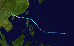
Typhoon Koryn, having developed well east of the Philippines on June 13, steadily strengthened as it moved westward, intensifying to a peak of 150 mph (240 km/h) winds on the 24th. It crossed northern Luzon the next day as a slightly weaker 130 mph (210 km/h) typhoon, and continued west-northwestward until hitting southern China (90 nautical miles southwest of Hong Kong on the 27th). Koryn slowly wound down, bringing heavy rain through China and northern Vietnam before dissipating on the 29th. Koryn was responsible for the loss of 37 people, as well as $14.5 million (1993 USD) in damage over the northern Philippines.

Tropical Depression 07W (Elang)

Tropical depression (PAGASA)
Tropical depression (SSHWS)
Elang Jun 18 1993 0718Z.png   Elang 1993 track.png
DurationJune 17 – June 20
Peak intensity55 km/h (35 mph) (10-min);
1004  hPa  (mbar)

Elang made landfall in the Philippines.

Severe Tropical Storm Lewis (Huling)

Severe tropical storm (JMA)
Category 2 typhoon (SSHWS)
Lewis Jul 10 1993 0754Z.png   Lewis 1993 track.png
DurationJuly 6 – July 13
Peak intensity110 km/h (70 mph) (10-min);
975  hPa  (mbar)

Lewis was one of many systems to hit the Philippines that year.

Tropical Storm Marian (Ibiang)

Tropical depression (JMA)
Tropical storm (SSHWS)
Marian Jul 14 1993 1940Z.png   Marian 1993 track.png
DurationJuly 13 – July 17
Peak intensity55 km/h (35 mph) (10-min);
1000  hPa  (mbar)

Marian stayed within the Philippine Sea.

Severe Tropical Storm Nathan

Severe tropical storm (JMA)
Category 1 typhoon (SSHWS)
Nathan Jul 24 1993 0646Z.png   Nathan 1993 track.png
DurationJuly 19 – July 25
Peak intensity100 km/h (65 mph) (10-min);
980  hPa  (mbar)

Nathan crossed Japan. 47 were killed in Kochi Prefecture.

Tropical Storm Ofelia (Luming)

Tropical storm (JMA)
Tropical storm (SSHWS)
Ofelia Jul 26 1993 1015Z.png   Ofelia 1993 track.png
DurationJuly 24 – July 27
Peak intensity85 km/h (50 mph) (10-min);
990  hPa  (mbar)

Ofelia moved over Japan.

Severe Tropical Storm Percy (Miling)

Severe tropical storm (JMA)
Category 1 typhoon (SSHWS)
Percy Jul 29 1993 1053Z.png   Percy 1993 track.png
DurationJuly 26 – July 30
Peak intensity110 km/h (70 mph) (10-min);
975  hPa  (mbar)

Percy also struck Japan.

Tropical Depression Narsing

Tropical depression (PAGASA)
Temporary cyclone north.svg  
DurationJuly 29 – July 30
Peak intensity55 km/h (35 mph) (10-min);

On July 29, PAGASA initiated advisories on a poorly organised tropical depression. The depression moved slowly towards the north-west before it dissipated during the next day. [3]

Typhoon Robyn (Openg)

Very strong typhoon (JMA)
Category 4 typhoon (SSHWS)
08-07-1993-0714-Robyn.png   Robyn 1993 track.png
DurationAugust 1 – August 11
Peak intensity155 km/h (100 mph) (10-min);
940  hPa  (mbar)

The near equatorial trough spawned a tropical depression on July 30 over the open Western Pacific waters. It tracked to the west-northwest, becoming a tropical storm on the 2nd and a typhoon on the 4th. Robyn turned more to the northwest, where it reached a peak intensity of 145 mph (230 km/h) winds on the 7th. It weakened to a 100 mph (200 km/h) typhoon before hitting southwestern Japan on the 9th, and became extratropical on the 10th over the Sea of Japan. Robyn caused 45 fatalities, 39 of which were from traffic related accidents, and $68 million in damage (1993 USD).

Severe Tropical Storm Steve (Pining)

Severe tropical storm (JMA)
Category 1 typhoon (SSHWS)
Steve Aug 10 1993 0637Z.png   Steve 1993 track.png
DurationAugust 5 – August 14
Peak intensity100 km/h (65 mph) (10-min);
980  hPa  (mbar)

Steve stayed clear from land.

Tropical Depression 15W

Tropical depression (SSHWS)
15W Aug 13 1993 0415Z.png   15-W 1993 track.png
DurationAugust 13 – August 14
Peak intensity45 km/h (30 mph) (1-min);
1002  hPa  (mbar)

Typhoon Tasha (Rubing)

Typhoon (JMA)
Category 1 typhoon (SSHWS)
Tasha Aug 20 1993 0758Z.png   Tasha 1993 track.png
DurationAugust 13 – August 22
Peak intensity120 km/h (75 mph) (10-min);
970  hPa  (mbar)

Tasha hit China in August.

Typhoon Keoni

Very strong typhoon (JMA)
Category 3 typhoon (SSHWS)
Keoni Aug 21 1993 0422Z.png   Keoni 1993 track.png
DurationAugust 19 (Entered basin) – September 3
Peak intensity165 km/h (105 mph) (10-min);
940  hPa  (mbar)

Keoni formed southeast of the Big Island of Hawaii on August 9, and was later classified as a named system south of the island chain. Keoni peaked as an intense Category 4 hurricane over open waters and lasted until the 29th, crossing the International Date Line and becoming a typhoon in the western Pacific, but never affected land.

Typhoon Vernon

Typhoon (JMA)
Category 1 typhoon (SSHWS)
Vernon Aug 24 1993 2216Z.png   Vernon 1993 track.png
DurationAugust 21 – August 28
Peak intensity130 km/h (80 mph) (10-min);
965  hPa  (mbar)

The cyclone dropped heavy rainfall across much of the Japanese archipelago. [4] A peak rainfall total occurred of 340 mm (13 in) at Mount Zaō, including a record 319 mm (12.6 in) in 24 hours. [5] A peak hourly rainfall total of 64 mm (2.5 in) was observed in Tokyo. [6] A wind gust of 76 km/h (47 mph) was recorded in Miyake-jima. [7] Vernon caused 2 fatalities and 4 injuries. [8]

Tropical Storm Winona (Saling)

Tropical storm (JMA)
Tropical storm (SSHWS)
Winona Aug 25 1993 0001Z.png   Winona 1993 track.png
DurationAugust 21 – August 29
Peak intensity75 km/h (45 mph) (10-min);
990  hPa  (mbar)

Winona hit China and Vietnam.

Super Typhoon Yancy (Tasing)

Very strong typhoon (JMA)
Category 4 super typhoon (SSHWS)
Yancy Sept 2 1993 0701Z.png   Yancy 1993 track.png
DurationAugust 29 – September 7
Peak intensity175 km/h (110 mph) (10-min);
925  hPa  (mbar)

The monsoon trough formed a tropical depression on August 27. It headed generally westward, reaching tropical storm strength on the 30th and typhoon strength on the 31st. Yancy turned to the northeast, where it rapidly intensified to a 150 mph (240 km/h) super typhoon on the 2nd. The storm weakened to a 135 mph (217 km/h) typhoon before making landfall on southwestern Japan on the 3rd, and dissipated 2 days later over the Sea of Japan. Yancy brought strong winds to Japan, amounting to 42 casualties and widespread damage.
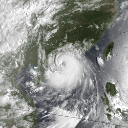
Severe Tropical Storm Zola (Unsing)

Severe tropical storm (JMA)
Tropical storm (SSHWS)
Zola Sep 8 1993 1956Z.png   Zola 1993 track.png
DurationSeptember 5 – September 9
Peak intensity95 km/h (60 mph) (10-min);
985  hPa  (mbar)

Zola was another weak system that hit Japan.

Typhoon Abe (Walding)

Very strong typhoon (JMA)
Category 3 typhoon (SSHWS)
Abe Sept 13 1993 0807Z.png   Abe 1993 track.png
DurationSeptember 9 – September 15
Peak intensity155 km/h (100 mph) (10-min);
945  hPa  (mbar)

Abe was another Typhoon that hit China.

Severe Tropical Storm Becky (Yeyeng)

Severe tropical storm (JMA)
Category 1 typhoon (SSHWS)
Becky Sept 17 1993 0005Z.png   Becky 1993 track.png
DurationSeptember 13 – September 18
Peak intensity100 km/h (65 mph) (10-min);
980  hPa  (mbar)

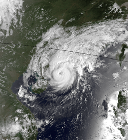
Becky struck China to the west of Macau at full force. The offshore waters in the southern and southwestern part of Hong Kong recorded hurricane-force winds where its hourly mean winds reached 122 km/h with gusts up to 176 km/h at Waglan Island. In Cheung Chau, winds increased significantly to 115 km/h hourly before under going maintenance; privately recorded its hourly winds of up to 128 km/h during its first hour of maintenance there in Cheung Chau, and up to 139 km/h 60-minute mean wind just before under going maintenance. In Tai Mo Shan, its hourly mean winds reached 155 km/h.

Becky was clearly underestimated and the hurricane signal 10 should have been hoisted as it was justified (hurricane-force winds recorded at southwestern part of Hong Kong when Becky traversed at about 110 km south-southwest of the Royal Observatory). Its maximum 10 minute sustained wind speed was estimated to be at around 150 km/h at its closet approach to Hong Kong.

The typhoon killed 1 taxi driver at a car accident in Hong Kong. As of 2017, Becky was revised and upgraded to a minimal typhoon.[ citation needed ]

Typhoon Dot (Anding)

Typhoon (JMA)
Category 1 typhoon (SSHWS)
Dot Sept 26 1993 0011Z.png   Dot 1993 track.png
DurationSeptember 19 – September 27
Peak intensity130 km/h (80 mph) (10-min);
965  hPa  (mbar)

Dot struck China as well. Initially posing a direct hit to Hong Kong but it slowly moved north, striking the coast of western Guangdong.

Typhoon Cecil

Typhoon (JMA)
Category 3 typhoon (SSHWS)
Cecil Sept 25 1993 1811Z.png   Cecil 1993 track.png
DurationSeptember 22 – September 27
Peak intensity150 km/h (90 mph) (10-min);
950  hPa  (mbar)

Cecil recurved out to sea.

Tropical Depression Binang

Temporary cyclone north.svg  
DurationSeptember 25 – September 25
Peak intensityWinds not specified;
1004  hPa  (mbar)

Super Typhoon Ed (Dinang)

Very strong typhoon (JMA)
Category 5 super typhoon (SSHWS)
Ed Oct 4 1993 1009Z.png   Ed 1993 track.png
DurationSeptember 30 – October 8
Peak intensity185 km/h (115 mph) (10-min);
915  hPa  (mbar)

Ed was a potent typhoon but did not affect land. It was also the only Category 5 of the season.

Typhoon Flo (Kadiang)

Typhoon (JMA)
Category 1 typhoon (SSHWS)
Flo Oct 3 1993 2300Z.png   Flo 1993 track.png
DurationOctober 1 – October 8
Peak intensity120 km/h (75 mph) (10-min);
970  hPa  (mbar)

Typhoon Flo hit the northern Philippines on October 4 as a minimal typhoon, having developed on the 28th from the monsoon trough. It stalled just off the west coast, and turned northeastward, becoming extratropical on the 9th. Flo caused at least 500 deaths from the heavy flooding on Luzon. Flo interacted with the nearby Ed, causing Flo to recurve eastwards. Flo’s recurving resulted prolonged rainfall across Luzon.

Tropical Storm Gene (Gundang)

Tropical storm (JMA)
Tropical storm (SSHWS)
Gene Oct 8 1993 2252Z.png   Gene 1993 track.png
DurationOctober 7 – October 10
Peak intensity65 km/h (40 mph) (10-min);
998  hPa  (mbar)

Gene was a weak system that stayed away from land.

Tropical Depression 28W (Epang)

Tropical depression (PAGASA)
Tropical depression (SSHWS)
Epang Oct 11 1993 2327Z.png   Epang 1993 track.png
DurationOctober 7 – October 13
Peak intensity45 km/h (30 mph) (10-min);
1008  hPa  (mbar)

The depression criss crossed land.

Severe Tropical Storm Hattie

Severe tropical storm (JMA)
Tropical storm (SSHWS)
Hattie Oct 24 1993 0300Z.png   Hattie 1993 track.png
DurationOctober 19 – October 25
Peak intensity95 km/h (60 mph) (10-min);
980  hPa  (mbar)

Hattie recurved from land.

Typhoon Ira (Husing)

Typhoon (JMA)
Category 4 typhoon (SSHWS)
Ira Oct 31 1993 1027Z.png   Ira 1993 track.png
DurationOctober 27 – November 5
Peak intensity150 km/h (90 mph) (10-min);
950  hPa  (mbar)

Ira struck the Philippines. It also wreaked havoc in Hong Kong, causing an aircraft to slide off the runway at Kai Tak Airport after landing in blind weather.

Tropical Storm Jeana

Tropical storm (JMA)
Tropical storm (SSHWS)
Jeana Nov 10 1993 2240Z.png   Jeana 1993 track.png
DurationNovember 5 – November 13
Peak intensity85 km/h (50 mph) (10-min);
992  hPa  (mbar)

Jeana stayed at sea.

Tropical Depression 32W (Indang)

Tropical depression (SSHWS)
32W Nov 18 1993 0802Z.png   32W 1993 track.png
DurationNovember 13 – November 19
Peak intensity45 km/h (30 mph) (1-min);
1002  hPa  (mbar)

32W was long-lived.

Tropical Depression 33W

Tropical depression (SSHWS)
33W Nov 18 1993 0600Z.png   33-W 1993 track.png
DurationNovember 18 – November 19
Peak intensity45 km/h (30 mph) (1-min);
1002  hPa  (mbar)

33W was short-lived.

Typhoon Kyle (Luring)

Typhoon (JMA)
Category 2 typhoon (SSHWS)
Kyle Nov 23 1993 0843Z.png   Kyle 1993 track.png
DurationNovember 17 – November 24
Peak intensity130 km/h (80 mph) (10-min);
960  hPa  (mbar)

Kyle was yet another Philippines striking system. It also hit Vietnam.

Typhoon Lola (Monang)

Typhoon (JMA)
Category 3 typhoon (SSHWS)
Lola Dec 8 1993 0901Z.png   Lola 1993 track.png
DurationDecember 1 – December 9
Peak intensity150 km/h (90 mph) (10-min);
955  hPa  (mbar)

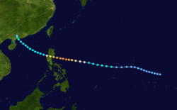
The near equatorial trough spawned a tropical depression on November 27. It moved westward without significant development until December 2, when it became a tropical storm. Lola became a typhoon 2 days later, and hit the Philippines on the 5th. It weakened to a tropical storm after crossing the islands, but restrengthened to a 125 mph (200 km/h) typhoon before hitting southern Vietnam on the 8th. Lola quickly dissipated, not after causing 308 fatalities, 230 of which were in the Philippines from the heavy rains.

Typhoon Manny (Naning)

Typhoon (JMA)
Category 4 typhoon (SSHWS)
Manny Dec 9 1993 1127Z.png   Manny 1993 track.png
DurationDecember 3 – December 16
Peak intensity140 km/h (85 mph) (10-min);
960  hPa  (mbar)

Manny, like Lola, developed from the near-equatorial trough on December 1. It headed westward, slowly strengthening to a tropical storm on the 4th. Due to a ridge to the north, it looped on the 7th and 8th and became a typhoon on the way. While heading southwestward towards the Philippines, Manny rapidly intensified to a 135 mph (220 km/h) typhoon before hitting the Philippines late on the 9th. It weakened over the islands, and upper level winds kept it from restrengthening much over the South China Sea. Manny dissipated on the 16th over the Malay Peninsula, after causing 230 deaths, only one week after Lola hit the same area.

Manny's track was unusual, given its time of year with a loop and a strengthening period to the southwest. However, it has a near-perfect analog; Typhoon Pamela in the 1982 Pacific typhoon season took a nearly identical track within days of Manny (though Pamela was much weaker than Manny).

Tropical Depression Oning

Tropical depression (PAGASA)
Temporary cyclone north.svg  
DurationDecember 14 – December 16
Peak intensity55 km/h (35 mph) (10-min);

A non-tropical system developed from the ITCZ of where Manny formed on December 11. It moved in a fairly fast westward direction as it gradually intensified into a weak tropical depression late on December 14. The PAGASA issued warnings on the depression as it reached peak intensity late on December 15, making landfall over the islands of Visayas.

Severe Tropical Storm Nell (Puring)

Severe tropical storm (JMA)
Category 1 typhoon (SSHWS)
Nell dec 25 1993 2315Z.jpg   Nell 1993 track.png
DurationDecember 20, 1993 – January 1, 1994
Peak intensity110 km/h (70 mph) (10-min);
975  hPa  (mbar)

Nell was the final system to hit the Philippines this year. 46 people were found dead due to Nell.

Storm names

During the season 28 named tropical cyclones developed in the Western Pacific and were named by the Joint Typhoon Warning Center, when it was determined that they had become tropical storms. These names were contributed to a revised list which started on mid-1989.

IrmaJackKorynLewisMarianNathanOfeliaPercyRobynSteveTashaVernonWinonaYancyZola
AbeBeckyCecilDotEdFloGeneHattieIraJeanaKyleLolaMannyNell

Philippines

AtringBiningKuringDalingElang
GoringHulingIbiangLumingMiling
NarsingOpengPiningRubingSaling
TasingUnsingWaldingYeyeng
Auxiliary list
AndingBinangKadiangDinangEpang
GundangHusingIndangLuringMonang
NaningOningPuring

The Philippine Atmospheric, Geophysical and Astronomical Services Administration uses its own naming scheme for tropical cyclones in their area of responsibility. PAGASA assigns names to tropical depressions that form within their area of responsibility and any tropical cyclone that might move into their area of responsibility. Should the list of names for a given year prove to be insufficient, names are taken from an auxiliary list, the first 6 of which are published each year before the season starts. Names not retired from this list will be used again in the 1997 season. This is the same list used for the 1989 season. PAGASA uses its own naming scheme that starts in the Filipino alphabet, with names of Filipino female names ending with "ng" (A, B, K, D, etc.). Names that were not assigned/going to use are marked in gray.

Season effects

This table summarizes all the systems that developed within or moved into the North Pacific Ocean, to the west of the International Date Line during 1993. The tables also provide an overview of a systems intensity, duration, land areas affected and any deaths or damages associated with the system.

NameDatesPeak intensityAreas affectedDamage
(USD)
DeathsRefs
Category Wind speedPressure
01W (Atring)February 28 – March 1Tropical depression55 km/h (35 mph)1010 hPa (29.83 inHg)PhilippinesNoneNone
IrmaMarch 8 – 19Severe tropical storm95 km/h (60 mph)985 hPa (29.09 inHg)Marshall Islands, Caroline Islands None10
03W (Bining)April 9 – 13Tropical depression55 km/h (35 mph)1002 hPa (29.59 inHg)Caroline Islands, PhilippinesNoneNone
04W (Kuring)April 19 – 26Tropical depression55 km/h (35 mph)1008 hPa (29.77 inHg)Caroline Islands, PhilippinesNoneNone
DalingMay 2 – 4Tropical depression45 km/h (30 mph)1006 hPa (29.71 inHg)PhilippinesNoneNone
JackMay 16 – 22Tropical depression65 km/h (40 mph)1008 hPa (29.77 inHg)Caroline Islands, Mariana IslandsNoneNone
Koryn (Goring)June 16 – 29Typhoon195 km/h (120 mph)905 hPa (27.02 inHg)Caroline Islands, Philippines, China$224 million37
07W (Elang)June 17 – 20Tropical depression55 km/h (35 mph)1008 hPa (29.77 inHg)PhilippinesNoneNone
Lewis (Huling)July 7 – 13Severe tropical storm95 km/h (60 mph)985 hPa (29.09 inHg)Philippines, South China, VietnamUnknownUnknown
TDJuly 13Tropical depressionNot specified1002 hPa (29.59 inHg)South ChinaNoneNone
Marian (Ibiang)July 14 – 16Tropical storm75 km/h (45 mph)1000 hPa (29.53 inHg)NoneNoneNone
TDJuly 17 – 22Tropical depressionNot specified1008 hPa (29.77 inHg)NoneNoneNone
NathanJuly 19 – 25Severe tropical storm100 km/h (65 mph)980 hPa (28.94 inHg)Mariana Islands, JapanUnknownUnknown
TDJuly 21Tropical depressionNot specified1008 hPa (29.77 inHg)NoneNoneNone
Ofelia (Luming)July 24 – 27Tropical storm85 km/h (50 mph)990 hPa (29.23 inHg)JapanUnknownUnknown
Percy (Miling)July 27 – 30Severe tropical storm100 km/h (65 mph)980 hPa (28.94 inHg)Mariana Islands, JapanUnknownUnknown
NarsingJuly 30 – 31Tropical depression55 km/h (35 mph)1000 hPa (29.53 inHg)NoneNoneNone
TDJuly 31Tropical depressionNot specified1002 hPa (29.59 inHg)Philippines, TaiwanNoneNone
Robyn (Openg)August 1 – 11Typhoon155 km/h (100 mph)940 hPa (27.76 inHg)Caroline Islands, Mariana Islands, Japan, South Korea$68 million45
Steve (Pining)August 6 – 14Severe tropical storm100 km/h (65 mph)980 hPa (28.94 inHg)Mariana Islands, Ryukyu IslandsNoneNone
15WAugust 13 – 14Tropical depression45 km/h (30 mph)1002 hPa (29.59 inHg)Marshall IslandsNoneNone
Tasha (Rubing)August 15 – 22Typhoon120 km/h (75 mph)970 hPa (28.79 inHg)Philippines, ChinaNoneNone
KeoniAugust 19 – September 3Typhoon165 km/h (105 mph)940 hPa (27.76 inHg)NoneNoneNone
VernonAugust 21 – 28Typhoon130 km/h (85 mph)960 hPa (28.35 inHg)JapanUnknown2 [8]
Winona (Saling)August 22 – 29Tropical storm75 km/h (45 mph)990 hPa (29.23 inHg)Philippines, VietnamUnknownUnknown
TDAugust 23 – 25Tropical depressionNot specified1002 hPa (29.59 inHg)Mariana IslandsNoneNone
Yancy (Tasing)August 29 – September 4Typhoon175 km/h (100 mph)925 hPa (27.32 inHg)Japan$1.67 billion48
Zola (Unsing)September 5 – 9Severe tropical storm95 km/h (60 mph)985 hPa (29.09 inHg)JapanNoneNone
TDSeptember 7 – 8Tropical depressionNot specified1006 hPa (29.71 inHg)PhilippinesNoneNone
Abe (Walding)September 9 – 15Typhoon155 km/h (100 mph)940 hPa (27.76 inHg)Philippines, Taiwan, ChinaUnknownNone
Becky (Yeyeng)September 13 – 18Typhoon120 km/h (75 mph)980 hPa (28.94 inHg)Philippines, South ChinaNone1
Dot (Anding)September 20 – 27Typhoon130 km/h (85 mph)965 hPa (28.65 inHg)Philippines, ChinaUnknownNone
CecilSeptember 23 – 27Typhoon155 km/h (100 mph)940 hPa (27.76 inHg)Mariana IslandsNoneNone
BinangSeptember 25Tropical depressionNot specified1004 hPa (29.65 inHg)NoneNoneNone
Ed (Dinang)September 30 – October 8Typhoon185 km/h (115 mph)915 hPa (27.32 inHg)Caroline Islands, Mariana IslandsNoneNone
Flo (Kadiang)October 1 – 8Typhoon185 km/h (115 mph)915 hPa (27.32 inHg)Philippines, Ryukyu IslandsUnknown10
28W (Epang)October 6 – 13Tropical depression45 km/h (30 mph)1002 hPa (29.59 inHg)Philippines, South ChinaNoneNone
Gene (Gundang)October 7 – 10Tropical storm65 km/h (40 mph)998 hPa (29.47 inHg)Caroline IslandsNoneNone
HattieOctober 19 – 25Severe tropical storm95 km/h (60 mph)980 hPa (28.94 inHg)Marshall IslandsNoneNone
TDOctober 22Tropical depressionNot specified992 hPa (29.29 inHg)NoneNoneNone
Ira (Husing)October 27 – November 5Typhoon150 km/h (90 mph)950 hPa (28.05 inHg)Caroline Islands, Mariana Islands, Philippines, ChinaUnknownUnknown
JeanaNovember 5 – 10Tropical storm85 km/h (50 mph)992 hPa (29.29 inHg)Caroline IslandsNoneNone
IndangNovember 12 – 13Tropical depression45 km/h (30 mph)1008 hPa (29.77 inHg)PhilippinesNoneNone
32WNovember 13 – 16Tropical depression45 km/h (30 mph)1002 hPa (29.59 inHg)Caroline IslandsNoneNone
33WNovember 17 – 19Tropical depression45 km/h (30 mph)1002 hPa (29.59 inHg)Marshall IslandsNoneNone
Kyle (Luring)November 17 – 24Typhoon130 km/h (80 mph)960 hPa (28.35 inHg)Philippines, Vietnam, CambodiaUnknown70
Lola (Monang)December 1 – 9Typhoon150 km/h (90 mph)955 hPa (28.20 inHg)Caroline Islands, Philippines, Vietnam, CambodiaUnknown308
Manny (Naning)December 3 – 16Typhoon140 km/h (85 mph)955 hPa (28.20 inHg)Philippines, Vietnam, ThailandUnknown230
OningDecember 14 – 16Tropical depression55 km/h (35 mph)1004 hPa (29.65 inHg)PhilippinesNoneNone
Nell (Puring)December 21, 1993 – January 1, 1994Severe tropical storm110 km/h (70 mph)975 hPa (28.79 inHg)PhilippinesNoneNone
Season aggregates
50 systemsFebruary 28, 1993 – January 1, 1994195 km/h (120 mph)905 hPa (27.02 inHg)>$1.96 billion>758

See also

Related Research Articles

<span class="mw-page-title-main">2005 Pacific typhoon season</span> Typhoon season in the Western Pacific Ocean

The 2005 Pacific typhoon season was the least active typhoon season since 2000, producing 23 named storms, of which 13 became typhoons. It was an event in the annual cycle of tropical cyclone formation, in which tropical cyclones form in the western Pacific Ocean. The season ran throughout 2005, though most tropical cyclones typically develop between May and October. The season's first named storm, Kulap, developed on January 13, while the season's last named storm, Bolaven, dissipated on November 20. The season's first typhoon, Haitang, reached typhoon status on July 13, and became the first super typhoon of the year three days later.

<span class="mw-page-title-main">2006 Pacific typhoon season</span> Typhoon season in the Western Pacific Ocean

The 2006 Pacific typhoon season was a near-average season which produced a total of 23 named storms, 15 typhoons, and six super typhoons. The season ran throughout 2006, though most tropical cyclones typically develop between May and October. The season's first named storm, Chanchu, developed on May 9, while the season's last named storm, Trami, dissipated on December 20.

<span class="mw-page-title-main">2003 Pacific typhoon season</span> Typhoon season in the Western Pacific Ocean

The 2003 Pacific typhoon season was a slightly below average yearlong period of tropical cyclogenesis exhibiting the development of 45 tropical depressions, of which 21 became named storms; of those, 14 became typhoons. Though every month with the exception of February and March featured tropical activity, most storms developed from May through October. During the season, tropical cyclones affected the Philippines, Japan, China, the Korean Peninsula, Indochina, and various islands in the western Pacific.

<span class="mw-page-title-main">2000 Pacific typhoon season</span> Typhoon season in the Western Pacific Ocean

The 2000 Pacific typhoon season marked the first year using names contributed by the World Meteorological Organization. It was a rather below-average season, producing a total of 23 tropical storms, 13 typhoons and 4 intense typhoons. The season ran throughout 2000, though typically most tropical cyclones develop between May and October. The season's first named storm, Damrey, developed on May 7, while the season's last named storm, Soulik, dissipated on January 4 of the next year.

<span class="mw-page-title-main">1999 Pacific typhoon season</span> Typhoon season in the Western Pacific Ocean

The 1999 Pacific typhoon season was the last Pacific typhoon season to use English names as storm names. It also featured the lowest number of typhoons on record with only five reaching this intensity. The season was a below-average season with only 20 named storms spawning. It had no official bounds; it ran year-round in 1999, but most tropical cyclones tend to form in the northwestern Pacific Ocean between May and November. These dates conventionally delimit the period of each year when most tropical cyclones form in the northwestern Pacific Ocean. The first named storm, Hilda, developed on January 6, while the last named storm, Gloria, dissipated on November 16.

<span class="mw-page-title-main">1995 Pacific typhoon season</span> Typhoon season in the Western Pacific Ocean

The 1995 Pacific typhoon season was a slightly below average season in terms of named storms, however it did feature a large number of intense typhoons. It occurred all year round, though most tropical cyclones formed between May and November.

<span class="mw-page-title-main">1994 Pacific typhoon season</span> Typhoon season in the Western Pacific Ocean

The 1994 Pacific typhoon season was an extremely active season in the annual cycle of tropical cyclone formation in the Western North Pacific, being the second most active season in the basin, only behind 1964. With a total of 36 tropical storms, where 20 of them reached typhoon strength and 6 further strengthening into super typhoons, during the course of the season, much like the Pacific hurricane season. The season had no official bounds and it ran year-round in 1994, but most tropical cyclones tend to form in the northwestern Pacific Ocean between May and November. Tropical storms that formed west of the date line were assigned a name by the Joint Typhoon Warning Center. The World Meteorological Organization-designated Regional Specialized Meteorological Centre for tropical cyclones for the region is the Japan Meteorological Agency. Tropical depressions that entered or formed in the Philippine area of responsibility were assigned a name by the Philippine Atmospheric, Geophysical and Astronomical Services Administration or PAGASA. This can result in some storms having two names.

<span class="mw-page-title-main">1990 Pacific typhoon season</span> Typhoon season in the Pacific Ocean

The 1990 Pacific typhoon season was another active season. It has no official bounds; it ran year-round in 1990, but most tropical cyclones tend to form in the northwestern Pacific Ocean between May and November. These dates conventionally delimit the period of each year when most tropical cyclones form in the northwestern Pacific Ocean.

<span class="mw-page-title-main">1980 Pacific typhoon season</span> Period of formation of tropical cyclones in the Western Pacific Ocean in 1980

The 1980 Pacific typhoon season was a slightly-below average season when compared to the long-term average, though it featured several intense storms. It ran year-round in 1980, but most tropical cyclones formed between June and December. These dates conventionally delimit the period of each year when most tropical cyclones form in the northwestern Pacific Ocean. A total of 28 tropical depressions formed this year in the Western Pacific, of which 24 became tropical storms and were assigned a name by the Joint Typhoon Warning Center. Beginning in March, tropical cyclones formed in each subsequent month through December. Of the 24 named storms, 15 storms reached typhoon intensity, of which 2 reached super typhoon strength.

<span class="mw-page-title-main">1979 Pacific typhoon season</span> Period of formation of tropical cyclones in the Western Pacific Ocean in 1979

The 1979 Pacific typhoon season featured the largest and most intense tropical cyclone recorded globally, Typhoon Tip. The season also experienced slightly below-average tropical cyclone activity. The season had no official bounds; it ran year-round in 1979, but most tropical cyclones tend to form in the northwestern Pacific Ocean between June and December. These dates conventionally delimit the period of each year when most tropical cyclones form in the northwestern Pacific Ocean.

<span class="mw-page-title-main">1967 Pacific typhoon season</span> Typhoon season in the Pacific Ocean

The 1967 Pacific typhoon season was one of the most active Pacific typhoon seasons on record, witnessing the formation of 35 tropical storms during the season. It began on January 1, 1967, though most storms usually form between June and December within the basin. The first storm of the season, Ruby, formed on January 28 west of the Philippines. The scope of this article is limited to the Pacific Ocean, north of the equator and west of the international date line. Storms that form east of the date line and north of the equator are called hurricanes; see 1967 Pacific hurricane season. Tropical depressions that are monitored by the United States' Joint Typhoon Warning Center (JTWC) were given a numerical designation with a "W" suffix, and any storms reaching 1-minute sustained winds of over 40 mph were given a name. Tropical depressions that enter or form in the Philippine area of responsibility are assigned a name by the Philippine Atmospheric, Geophysical and Astronomical Services Administration or PAGASA. This can often result in the same storm having two names.

<span class="mw-page-title-main">1963 Pacific typhoon season</span>

The 1963 Pacific typhoon season has no official bounds; it ran year-round in 1963, but most tropical cyclones tend to form in the northwestern Pacific Ocean between June and December. These dates conventionally delimit the period of each year when most tropical cyclones form in the northwestern Pacific Ocean.

<span class="mw-page-title-main">Typhoon Kujira (2003)</span> Pacific typhoon in 2003

Typhoon Kujira, known in the Philippines as Typhoon Amang, was a long-lived tropical cyclone that lasted for 16 days and affected the island nations of Micronesia, Taiwan, and Japan in April 2003, as well as the earliest typhoon in a calendar year to ever make landfall on the latter. Forming from a broad area of disturbed weather as a tropical depression on April 9 well removed from any landmasses, Kujira quickly intensified in its early stages, and was upgraded to a tropical storm just two days after cyclogenesis. Strengthening slowed afterwards, though the storm attained typhoon intensity on April 14. Intensification continued and late on April 15, Kujira reached its peak intensity with winds of 165 km/h (103 mph) and a minimum barometric pressure of 930 mbar. Following peak intensity, Kujira began to track northwest and oscillate in strength, cresting an additional two times in intensity. On April 21, the typhoon was downgraded to tropical storm intensity and began to track erratically for several days east of Taiwan. However, on April 24, Kujira resumed a northward track and begin to weaken, and on April 24 was downgraded to tropical depression strength as it made landfall on Kyushu. Following landfall Kujira transitioned into an extratropical cyclone and continued to persist before these extratropical remnants crossed the International Dateline towards the end of April 2003.

<span class="mw-page-title-main">Typhoon Yancy (1993)</span> Pacific typhoon in 1993

Typhoon Yancy, known in the Philippines as Typhoon Tasing, was one of the costliest and most intense tropical cyclones to strike Japan on record. Yancy was the sixth typhoon of the annual typhoon season and sixth tropical cyclone overall to impact Japan that year. Developing out of an area of disturbed weather in the open northwest Pacific on August 29, 1993, the precursor to Yancy tracked westward and quickly intensified to reach tropical storm strength on August 30. Just two days later, the tropical storm reached typhoon intensity as it recurved towards the northeast. A period of rapid intensification followed, allowing Yancy to quickly reach super typhoon intensity. The strong tropical cyclone reached peak intensity on September 2 with maximum sustained winds of 175 km/h (109 mph). The following day Yancy made its first landfall on Iōjima at nearly the same strength; over the course of the day the typhoon would make three subsequent landfalls on Japanese islands. Land interaction forced the tropical cyclone to weaken, and after its final landfall on Hiroshima Prefecture, Yancy weakened below typhoon intensity. After emerging into the Sea of Japan, Yancy transitioned into an extratropical cyclone; these remnants persisted as they meandered in the sea before dissipating completely on September 7.

<span class="mw-page-title-main">Typhoon Khanun (2005)</span> Pacific typhoon in 2005

Typhoon Khanun, known in the Philippines as Typhoon Kiko, was the strongest tropical cyclone to make landfall on Zhejiang Province since Wanda in 1956. Khanun developed from an area of convection east-southeast of Yap on September 5, thereafter tracking northwestward. The precursor reached tropical storm status on September 7 and typhoon intensity the next day. The tropical cyclone reached its peak intensity on September 10 with winds estimated at 155 km/h (100 mph) and a minimum barometric pressure of 945 mbar. After weakening slightly, Khanun moved ashore Zhejiang Province the next day, weakening further as it tracked over land. After recurving into the Yellow Sea on September 12, Khanun became extratropical; these remnants continued to track into the open North Pacific before they were last noted on September 16.

<span class="mw-page-title-main">Tropical Storm Irving (1992)</span> Pacific tropical storm in 1992

Tropical Storm Irving, known in the Philippines as Tropical Depression Edeng, was an early-season tropical cyclone that struck southern Japan during August 1992. A distinct but weak low-pressure area developed within the Western Pacific monsoon trough. A tropical depression formed on July 31, and following an increase in both organization and thunderstorm activity, the depression attained tropical storm intensity on the morning of August 2. After tracking west-northwest and then north, Irving turned to the northeast, and attained peak intensity a day later. In response to a subtropical ridge to the north, the system began to track west-northwestward, and made landfall at maximum intensity over southwestern Shikoku at peak intensity. Irving turned sharply to the west and rapidly weakened, dissipating over the Korea Strait at noon on August 5.

<span class="mw-page-title-main">Typhoon Janis</span> Pacific typhoon in 1992

Typhoon Janis, known in the Philippines as Typhoon Gloring, was an early-season typhoon that struck Japan during August 1992. An area of disturbed weather formed near Pohnpei in late-July 1992, and after an increase in thunderstorm activity, a tropical depression developed on August 3. After passing near Guam, Janis tracked generally westward, and on August 5, the storm was believed to have attained typhoon intensity. After intensifying at a brisk pace, Janis attained peak intensity on August 6 near Okinawa. Thereafter, the typhoon began to weaken and accelerate as it recurved towards Kyushu, where it made landfall on the next day. Land interaction took its toll on the typhoon as it tracked northeast, paralleling the western coast of Honshu. On August 9, Janis transitioned into an extratropical low over Hokkaido.

<span class="mw-page-title-main">Typhoon Kent (1992)</span> Pacific typhoon in 1992

Typhoon Kent was a strong mid-season typhoon that struck southern Japan during August 1992. An area of convection developed east of the International Date Line. Tracking west-northwestward, a tropical depression developed on August 5, and the next day, intensified into a tropical storm. On August 8, increased vertical wind shear caused convection to decrease, although Kent strengthened into a typhoon on the next day. An eye then appeared as conditions aloft became more conducive, and on August 11, Kent attained its peak intensity. Under the influence of a subtropical ridge located to its north, the typhoon initially continued to move west-northwestward before turning towards Kyushu. The storm steadily weakened prior to making landfall on August 18 just below typhoon intensity. The mountainous terrain of Japan accelerated the weakening trend, and on August 20, Kent dissipated.

<span class="mw-page-title-main">Tropical Storm Percy (1993)</span>

Tropical Storm Percy, known in the Philippines as Tropical Storm Miling, was an early-season tropical cyclone that passed through Japan during July 1993. An area of disturbed weather developed in the Philippine Sea on July 26. Gradual development ensued and on July 27, the disturbance was classified as a tropical depression. The following morning, the depression was upgraded into Tropical Storm Percy. Moving north-northwest, Percy slowly deepened and obtained its peak intensity of 115 km/h (70 mph) and a minimum barometric pressure of 975 mbar (28.79 inHg). Late on July 29, Percy passed over Kyushu and began to weaken. Percy was downgraded to a tropical depression on July 30 and dissipated completely two days later.

<span class="mw-page-title-main">Tropical Storm Ofelia</span> Pacific tropical storm in 1993

Tropical Storm Ofelia, known in the Philippines as Tropical Storm Luming, was an early-season tropical cyclone that passed south Japan during July 1993. An area of disturbed weather developed from the Western Pacific monsoon trough in late July 1993. The disturbance organized into a tropical depression on July 24, and the next day developed into a tropical storm. Tracking west-northwestward, Ofelia slowly deepened and attained its peak intensity of 80 km/h (50 mph) and a minimum barometric pressure of 994 mbar (29.4 inHg) at noon on July 26. On the next day, the storm made landfall shortly before weakening to a tropical depression. On July 27, Ofelia transitioned into an extratropical cyclone.

References

  1. Gary Padgett. May 2003 Tropical Cyclone Summary. Archived September 25, 2006, at the Wayback Machine Retrieved 2006-08-26.
  2. "1993 ATCR TABLE OF CONTENTS". Archived from the original on 2011-06-07. Retrieved 2010-01-01.
  3. "Tropical Cyclone Weekly Summary #104 (July 25 - August 1, 1993)".
  4. Asanobu, Kitamoto. Typhoon 199311 (Robyn). Digital Typhoon (Report). National Institute of Informatics . Retrieved October 1, 2017.
  5. Asanobu, Kitamoto. AMeDAS ZAOSAN (35476) @ Typhoon 199311. Digital Typhoon (Report). National Institute of Informatics. Retrieved October 1, 2017.
  6. Asanobu, Kitamoto. AMeDAS TOKYO (44131) @ Typhoon 199311. Digital Typhoon (Report). National Institute of Informatics. Retrieved October 1, 2017.
  7. Asanobu, Kitamoto. AMeDAS MIYAKEJIMA (44226) @ Typhoon 199311. Digital Typhoon (Report). National Institute of Informatics. Retrieved October 1, 2017.
  8. 1 2 Joint Typhoon Warning Center; Naval Pacific Meteorology and Oceanography Center (1994). Annual Tropical Cyclone Report: 1993 (PDF) (Report). United States Navy, United States Air Force. p. 56. Archived from the original (PDF) on March 4, 2016. Retrieved May 11, 2020.