Typhoon Yancy (1993)

Last updated
Map key
  Tropical depression (≤38 mph, ≤62 km/h)
  Tropical storm (39–73 mph, 63–118 km/h)
  Category 1 (74–95 mph, 119–153 km/h)
  Category 2 (96–110 mph, 154–177 km/h)
  Category 3 (111–129 mph, 178–208 km/h)
  Category 4 (130–156 mph, 209–251 km/h)
  Category 5 (≥157 mph, ≥252 km/h)
  Unknown
Storm type
Disc Plain black.svg Tropical cyclone
Solid black.svg Subtropical cyclone
ArrowUp.svg Extratropical cyclone, remnant low, tropical disturbance, or monsoon depression

In late August, an area of convection began to persist in the open northwestern Pacific, well removed from any landmasses. The Joint Typhoon Warning Center  (JTWC) started to monitor the disturbance at 1200  UTC on August 27. [2] Aided by a southwesterly monsoonal wind flow and in an area of favorable conditions, the system organized, and at 0600 UTC on August 28, the JTWC issued a Significant Tropical Weather Advisory on the disturbance. [3] Organization continued throughout the day's course, and the system was classified by the Japan Meteorological Agency  (JMA) as a tropical depression at 0000 UTC on August 29. [4] Shower activity at that time began to coalesce more closely around the system's center of circulation, prompting the JTWC to issue a Tropical Cyclone Formation Alert an hour later. Based on satellite intensity estimates, the agency also reclassified the system as a tropical depression at 0600 UTC that day. [3] At the time, the depression was positioned roughly 1,000 km (620 mi) northwest of Guam. [5] Through tropical cyclogenesis, the primitive depression tracked westward, in the direction of Taiwan. [3] At 0000 UTC on August 30, the JMA upgraded the system to tropical storm intensity, [4] followed by the JTWC six hours later based on a ship report in the vicinity of the cyclone. [3]

Yancy making landfall on Kyushu on September 3 Typhoon Yancy 3 Sep 1993 0650z.png
Yancy making landfall on Kyushu on September 3

Yancy continued to gradually intensify, and according to the JMA the storm reached severe tropical storm intensity at 1200 UTC on August 31. [4] By this time, Yancy started to curve towards the northwest. [5] Later that day, the tropical storm began developing a banding eye feature. This was reflected in satellite intensity estimates, prompting the JTWC to upgrade Yancy to typhoon status. [3] The JMA maintained the storm's severe tropical storm status through this period, though on September 1 the agency initiated 3-hour position fixes in contrast to their usual 6-hour fix procedure; at 0300 UTC that day the JMA upgraded Yancy to typhoon intensity. Upon upgrade, Yancy was estimated to have a minimum barometric pressure of 965  mbar (hPa; 28.50  inHg). [4] At the time the typhoon was positioned approximately 500 km (310 mi) south-southwest of Okinawa. [5] Rapid intensification ensued, [3] and just nine hours later the JTWC estimated Yancy's winds to have equated to that of a Category 3 on the Saffir–Simpson scale. [2] The JTWC upgraded the typhoon to super typhoon status at 0600 UTC on September 3 as one-minute sustained winds were estimated to have reached the threshold of 130 knots (240 km/h; 150 mph). [3] Three hours later the JMA estimated Yancy to have peaked in strength with ten-minute sustained winds of 175 km/h (109 mph) and a minimum barometric pressure of 925 mbar (925 hPa; 27.3 inHg); this intensity would be held for the following 18 hours. [4]

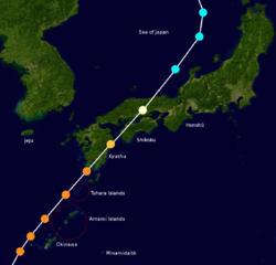
Only minimal weakening occurred in the immediate hours following peak intensity, and at around 0600 UTC on September 3, Yancy passed directly over Iōjima. [4] Tracking rapidly northeastward at around 40 km/h (25 mph), [5] Yancy made a second landfall on Kagoshima Prefecture within an hour later at the same intensity; [4] at the time this made Yancy the strongest tropical cyclone ever to make landfall on Japan since Typhoon Shirley in 1965, 28 years prior. [3] [6] Land interaction with Kyushu further weakened Yancy, [5] but the system remained at typhoon intensity upon its landfall on western Ehime Prefecture at around 1400 UTC that day. The JTWC estimated that the typhoon was still maintaining Category 3 intensity upon landfall on Ehime. [2] This particular landfall greatly weakened Yancy, and despite the storm briefly emerging over intra-insular waters, was only a minimal typhoon by the time of its final landfall on Hiroshima Prefecture at 1600 UTC that day. Shortly following the tropical cyclone's final landfall, Yancy weakened below typhoon intensity to severe tropical storm classification. Continuing to track northeast, the weakening cyclone underwent extratropical transition and was assessed to have fully transitioned into an extratropical storm by 1200 UTC on September 4 while located in the northeastern Sea of Japan. [4] [5] Yancy's extratropical remnants persisted for several days as they meandered within the Sea of Japan before dissipating by 1200 UTC on September 7. [4]

Preparations

In preparation for Typhoon Yancy, bus and rail services in potentially affected areas were halted. Some schools were also closed. Though no initial evacuation orders were made, caution was advised to people living in Kyushu. [7] Forecasts prior to Yancy's landfalls on Japan raised fears that the storm would be one of the strongest in the past 50 years to strike the country. In Okinawa, 15,000 passengers were stranded after most flights arriving and departing from the island were cancelled by airlines. [8] An additional 330 domestic flights were cancelled across western Japan, [9] stranding 5,600 persons. [10] As Yancy neared the country, approximately 4,600 people were forced to evacuate from flood and landslide-prone areas of Kagoshima. [9] Pop star Michael Jackson postponed a scheduled performance in Taiwan, potentially as a result of Typhoon Yancy. However, these claims were denied by his tour promoters and associated staff. [11]

Impact and aftermath

Enlarged track of Typhoon Yancy between September 2 and September 4 depicting the storm's path in relation to several Northwest Pacific islands. Yancy (2003) track near Japan.png
Enlarged track of Typhoon Yancy between September 2 and September 4 depicting the storm's path in relation to several Northwest Pacific islands.

Upon Yancy's first landfall on Japan, the tropical cyclone became the strongest tropical cyclone to strike the country in over three decades. [3] [9] Across Japan, a total of 10,447 homes were inundated, with 1,892 other homes suffering complete destruction. Yancy killed 48 people and injured 266 others. [12] Most of the deaths were the result of widespread flooding and landslides. [13] Overall, damage costs in Japan as a result of Yancy reached ¥175.5 billion (US$1.67 billion). Unadjusted for inflation, this would have at the time made Yancy the third costliest tropical cyclone in Japanese history, only behind Typhoon Bess in 1982 and Typhoon Mireille in 1991. [12] [14] Insured losses from Yancy in Japan reached ¥97.7 billion (US$928 million). [12] As a result of precautionary measures taken during the course of Yancy's trek through the country, at least 245,000 rail passengers and 15,000 airline passengers became stranded. [13] Yancy's potential impacts were exacerbated by the impacts of Typhoon Robyn in mid-August and significant rainstorms a week prior to Yancy's landfall. [15] In the direct aftermath of Typhoon Yancy, personnel from the Japan Self-Defense Forces were dispatched to rescue victims of the typhoon and recover dead bodies. [16]

Ryukyu Islands

Passing within 110 km (68 mi) of Okinawa Island on September 2, Yancy brought gusty winds to the island. At Kadena Air Base, sustained winds reached as high as 88 km/h (55 mph), with gusts peaking at 142 km/h (88 mph). [3] Rainfall on the island peaked at 397 mm (15.6 in) in Gusuku. The same station observed 360 mm (14 in) of rain over a 24-hour period. [12] Of all islands in Okinawa Prefecture, Kume Island sustained the worst impacts from Yancy. The eye of the typhoon passed directly over the island, resulting in a station observing a record low barometric pressure of 928 mbar (928 hPa; 27.4 inHg). The same station also clocked a wind gust at 194 km/h (121 mph). Large swaths of sugarcane crops were damaged. On the coast, strong waves damaged fishing boats and ports. [17] One person who went missing on the coast was later found dead. [18] Strong winds inland unroofed buildings and toppled power lines. Twenty-two buildings were completely destroyed, with an additional 516 sustaining at least partial damage. Total damage costs on Kume and Naha islands amounted to ¥1.8 billion (US$17.3 million), and two people were killed. [17]

Heavy agricultural damage also occurred on Ishigaki Island. Sugarcane crops were severely impacted, with losses reaching ¥35 million (US$330,000) and accounting for approximately 80.5% of all sugarcane crops on the island. Significant damage was also inflicted on other fruit and vegetable crops. Total agricultural losses on Ishigaki reached ¥43.6 million (US$410,000). On nearby Taketomi Island, similar agricultural damage ensued. [19] To the east, the Miyako Islands also suffered extensive damage. Heavy rainfall triggered widespread flooding, which took a toll on infrastructure and agriculture. Ten buildings sustained at least partial damage, with one completely demolished. In addition, three dikes were breached by floodwater. Roughly 4,478  ha (11,065  ac) of farmland were damaged. Agricultural damage there amounted to ¥309 million (US$2.9 million). [20]

Kyushu

Typhoon Yancy (Tasing)
Yancy Sept 2 1993 0701Z.png
Typhoon Yancy near peak intensity on September 2
Costliest Known Japan typhoons
RankTyphoonSeasonDamage
(2022 USD)
1 Mireille 1991 $21.5 billion
2 Hagibis 2019 $17.2 billion
3 Jebi 2018 $15.2 billion
4 Songda 2004 $14.4 billion
5 Faxai 2019$11.4 billion
6 Bart 1999 $10.1 billion
7 Bess 1982 $7.22 billion
8 Tokage 2004 $3.56 billion
9 Fran 1976 $3.39 billion
10 Yancy 1993 $3.38 billion
Source:

Kyushu was the first of Japan's four main islands to be impacted by Yancy and suffered the worst effects as a result. [4] [5] Floods and power outages were widespread, with about 700,000 homes on the island without power at one point. [21] Kagoshima Prefecture was the location of the typhoon's first and second landfalls and as such major damage occurred there. [22] Rainfall in the prefecture peaked at 375 mm (14.8 in) in Takatoge. However, higher hourly rainfall rates were reported at stations in Mizobe and Makurazaki. Off the coast, strong storm surge was reported, resulting in damage along the coast. In Sata, waves were estimated to be 11.5 m (38 ft) high. Widespread flash floods and landslides were commonplace across Kagoshima. Nine people were killed in a single landslide incident. [22] Another landslide in Kinpo, Kagoshima trapped 20 people. [23] In Kawanabe, a single mudslide killed nine persons and destroyed 20 homes. [24] A total of 31 landslides occurred throughout Kaghsima. Widespread power outages also took place, which affected 384,000 houses. Prefecture-wide, 209 homes were demolished and 626 sustained partial damage. Overall, damage costs in Kagoshima amounted to ¥43.9 billion (US$420 million), and 33 lives were lost. An additional 163 persons were injured. [22]

Despite not being a point of landfall, Miyazaki Prefecture was the most severely affected region of Japan. [25] Many of the highest rainfall totals recorded in Japan took place in Miyazaki Prefecture. A weather station in Mitate, located in the town of Hinokage, observed 577 mm (22.7 in) of rain, far more than any other station in the country. The same station reported 543 mm (21.4 in) of its rainfall total in a 24-hour period, which still exceeded the storm totals of any other Japanese weather station. [12] High storm surge generated by Yancy caused coastal inundation in Hyūga, which flooded the first floors of many buildings. Several fishing boats in a harbor off of Nobeaka capsized due to wave action. River swelling caused by heavy precipitation and flooding washed away four bridges prefecture-wide. Further inland many homes were unroofed as a result of strong winds. A total of 347 homes were damaged, and of those 38 were destroyed. Overall damage totaled ¥88.8 billion (US$840 million), primarily as a result of agricultural loss, and two people were killed. [25]

Northern Kyushu

Damage in Kumamoto Prefecture was considerably less in comparison with Miyazaki and Kagoshima prefectures but nonetheless remained significant. Winds gusting as high as 94 km/h (58 mph) resulted in the destruction of several homes. The strong winds also toppled and uprooted numerous trees, including a patch of trees 1,670 hectares (4,100 acres) in area in the southern portion of the prefecture. Landslides were also commonplace, blocking homes and destroying additional buildings. Damage in the prefecture reached ¥30.5 billion (US$290 million), primarily to forestry, where damage in that sector alone totaled ¥21 billion ($200 million). One person in Kumamoto Prefecture was killed after a falling incident while five others were injured. [26]

Ōita Prefecture was primarily impacted by heavy rainfall from Yancy, resulting in widespread flooding. [27] Precipitation peaked at 422 mm (16.6 in) in Ōita, the second highest rainfall amount in Japan. [12] Four people were killed after two buildings collapsed as a result of an overflowing river. Another person was killed due to a flood-triggered landslide. The floods destroyed 28 homes and inundated another 302 across Ōita. In addition to residential damage, the floods inundated large swaths of agricultural land, leading to soil erosion. Crops, in particularly pears, were greatly affected. Approximately 1,074 hectares (2,650 acres) of arable land was eroded. Across the prefecture, agricultural damage amounted to ¥26.8 billion (US$250 million). The floods also caused widespread clean water shortages, particularly in Kusu District. Overall, damage caused by Yancy in Ōita Prefecture was estimated at ¥42.4 billion (US$402 million), and seven people were killed. [27]

Nagasaki, Saga, and Fukuoka prefectures were less affected by Yancy relative to other regions in Kyushu. [12] Nagasaki Prefecture was primarily impacted by the typhoon's storm surge. Wave heights peaked at 8 m (26 ft) off of Miiraki. The wave action caused some coastal damage. Further inland, damage lessened, and limited to a single landslide. Damage in Nagasaki totaled ¥1.7 billion (US$16 million). [28] In Saga, excessive rainfall caused widespread crop damage and suspended various transportation services. Damage estimates in Saga were slightly less than in Nagasaki, totaling ¥1.6 billion (US$15 million). [29] Flooding in Fukuoka Prefecture resulted in two landslides and destroyed four buildings. Eighty-nine other buildings were inundated by floodwater. Damage there totaled ¥2.4 billion (US$23 million), and one person was killed. [30]

Shikoku

Shikoku was the second of Japan's four main islands that Yancy made landfall on. Ehime Prefecture in Shikoku was the site of Yancy's third landfall. [12] A high storm surge swamped coastal regions, damaging fishing boats and other shoreline structures. A total of 33 boats were reportedly damaged. Heavy rainfall blocked roads, flooded buildings, and triggered landslides. Inundation was reported in 1,237 buildings prefecture wide. Twelve landslides occurred, and dikes were breached in 13 locations. Power outage also occurred in earnest in Ehime Prefecture, with as many as 37,300 households losing electricity at one point. Two people were killed, and five others were injured. Damage in Ehime as a result of Yancy totaled ¥4.7 billion (US$44 million). [31] Damage was much more considerable in Kōchi Prefecture, where damage totaled ¥5 billion (US$48 million). Rainfall peaked at 384 mm (15.1 in) in Funato; this was the highest rainfall total on Shikoku Island. [12]

Honshū

See also

Notes

  1. All measurements of maximum sustained wind are taken over a period of 10 minutes unless otherwise noted.
  2. All monetary estimates and statistics are in 1993  United States dollars unless otherwise noted.

Related Research Articles

<span class="mw-page-title-main">Typhoon Prapiroon (2000)</span> Pacific typhoon in 2000

Typhoon Prapiroon, known in the Philippines as Typhoon Lusing, was the costliest tropical cyclone to strike the Korean Peninsula and the eighth costliest in the West Pacific on record.

<span class="mw-page-title-main">Typhoon Chaba (2004)</span> Pacific typhoon in 2004

Typhoon Chaba was the strongest tropical cyclone in the western Pacific during 2004 and caused a swath of damage from the Mariana Islands to Japan from August through September of that year. Chaba was the Japan's second costliest storm during the season, only behind Songda in September, and peaked as a typhoon with maximum sustained winds equivalent to that of a Category 5 on the Saffir–Simpson hurricane wind scale.

<span class="mw-page-title-main">Tropical Storm Linfa (2003)</span> Pacific severe tropical storm in 2003

Severe Tropical Storm Linfa, known in the Philippines as Tropical Storm Chedeng, brought deadly flooding to areas of the Philippines and Japan in May and June 2003. The fourth named storm within the northwestern Pacific that year, Linfa developed as a tropical depression just off the western coast of Luzon on May 25. The disturbance quickly intensified to reach tropical storm intensity a few hours after cyclogenesis. However, intensification leveled off as Linfa executed a small clockwise loop before a subsequent landfall on Luzon on May 27. Due to land interaction the storm temporarily weakened and decoupled before reforming in the Philippine Sea. Afterwards Linfa began reintensifying and reached its peak intensity on May 29 with maximum sustained winds of 100 km/h (65 mph) and a barometric pressure of 980 mbar. Following its peak the tropical storm began to deteriorate and transitioned into an extratropical cyclone on May 30; these extratropical remnants continued to track northward through Japan before dissipating in the Sea of Okhotsk on June 4.

<span class="mw-page-title-main">Typhoon Flo (1990)</span> Pacific typhoon in 1990

Typhoon Flo, known in the Philippines as Typhoon Norming, was a long-lived typhoon that brought destruction to much of Japan during September 1990. Flo originated from an area of convection that first formed to the southeast of the Marshall Islands on September 7. Five days later, the disturbance obtained tropical depression status, and on September 13, intensified into a tropical storm. Tracking west-northwest as it rounded a subtropical ridge, Flo slowly deepened, and on September 15, became a typhoon. After developing an eye, Flo began to rapidly intensify, and on September 17, Flo attained peak intensity. Shortly thereafter, the typhoon began to recurve to the northeast towards Honshu in response to deepening troughs to the northwest and north of the system, which resulted in a weakening trend due to increased vertical wind shear despite remaining over warm water. On September 19, Flo made landfall on southern Honshu, becoming the first typhoon to hit the Kii Peninsula in 11 years, and thereafter started to transition into an extratropical cyclone. The extratropical remnants of Flo were last noted on the morning of September 22.

<span class="mw-page-title-main">Tropical Storm Luke (1991)</span> Pacific tropical storm in 1991

Tropical Storm Luke, known in the Philippines as Tropical Storm Pepang, was a short-lived tropical storm that brushed Japan during September 1991. Tropical Storm Luke formed from a disturbance that moved through the Northern Marianas and became a tropical depression on September 14 just to the west of the islands. The depression began to slowly intensify as it moved towards the west-northwest and Tropical Storm Luke was named on September 15. Luke reached peak intensity prior to recurving to the northeast and weakening due to increased shear. Tropical Storm Luke then paralleled the southeastern Japan coastline before transitioning into an extratropical cyclone. Overall, 12 people were killed and 23 others were injured. A total of 225 houses were destroyed while 52,662 others were flooded. There were reports of 644 landslides and roads were damaged at 418 locations. Rivers crested at 18 spots and six bridges were washed away. Greater than 40 domestic flights were cancelled. A total of 103 bullet trains were cancelled and 160 others delayed between Tokyo and Osaka, which left 315,000 people stranded. Additionally, 11,999 trains were halted in eastern and northern Japan, stranding 750,000 passengers. Two ships as well as 4,973 ha of farmland were damaged. Monetary damage totaled ¥24.2 billion yen (US$179 million).

<span class="mw-page-title-main">Typhoon Saomai (2000)</span> Pacific typhoon in 2000

Typhoon Saomai, known in the Philippines as Typhoon Osang, was a long-tracked and intense tropical cyclone that brought flooding rainfall in Japan and the Korean peninsula in September 2000. The torrential precipitation in Japan was considered some of the worst in the past century.

<span class="mw-page-title-main">Typhoon Orchid (1991)</span> Pacific typhoon in 1991

Typhoon Orchid, known in the Philippines as Typhoon Sendang, was a long-lived typhoon that brushed Japan during October 1991. An area of disturbed weather formed near the Caroline Islands in early October. A mid-latitude cyclone weakened a subtropical ridge to its north, allowing the disturbance to slowly gain latitude, and on October 3, the system organized into a tropical depression. On the next day, the depression intensified into Tropical Storm Orchid. Continuing to intensify, the cyclone strengthened into a typhoon on the morning of October 6. Typhoon Orchid tracked due westward south of subtropical ridge while rapidly intensifying, and on October 7, Orchid reached its peak intensity. Shortly after its peak, the typhoon began to recurve north as the ridge receded. After interacting with Typhoon Pat, Orchid weakened below typhoon intensity on October 12. After accelerating to the northwest while gradually weakening, Orchid transitioned into an extratropical cyclone on October 14.

<span class="mw-page-title-main">Tropical Storm Winona (1990)</span> Pacific tropical storm in 1990

Tropical Storm Winona struck Japan during August 1990. An area of disturbed weather developed within the monsoon trough, located over the East China Sea, on August 4. Despite the presence of strong wind shear, a tropical depression developed later that day. The depression initially tracked northeast, bypassing the southern tip of Kyushu. Thereafter, the depression turned southeast, and on August 6, was believed to have obtained tropical storm intensity. In response to a building subtropical ridge to its southeast, Winona veered north while gradually intensifying. On August 9, Winona peaked in intensity, and while near peak intensity, made landfall in Shizuoka Prefecture early the following morning. Winona transitioned into an extratropical cyclone on August 11, and was last observed on August 14.

<span class="mw-page-title-main">Typhoon Zola</span> Pacific typhoon in 1990

Typhoon Zola struck Japan during August 1990. An area of disturbed weather developed during mid-August to the west of Guam. The disturbance developed into a tropical depression on August 16 while tracking eastward. Decreased wind shear aided in intensification, and it is estimated that the depression strengthened into a tropical storm on August 17. Continuing to intensify, Zola turned northwest in response to a subtropical ridge to its east before obtaining typhoon intensity on August 20. Typhoon Zola reached its peak intensity the next day. After weakening slightly, the storm moved ashore on Honshu. On August 23, the system transitioned into an extratropical cyclone over the Sea of Japan.

<span class="mw-page-title-main">Typhoon Gene</span> Pacific typhoon in 1990

Typhoon Gene, known in the Philippines as Typhoon Oyang, struck Japan during late September 1990. An area of disturbed weather formed several hundred kilometers south-southeast of Okinawa on September 18. Gradual development occurred as it tracked generally westward, and on September 22, the disturbance developed into a tropical depression. The depression intensified into a tropical storm the next day. Continuing to steadily intensify, Gene turned northwest and became a severe tropical storm on September 25. In the evening, Gene was declared a typhoon, and on September 26, attained its maximum intensity. Gene leveled off in intensity while recurving towards Japan. After brushing Kyushu and Shikoku on September 29 and Honshu on September 20, Gene weakened back to a tropical storm. On September 30, Gene transitioned into an extratropical cyclone, which was last noted on October 1.

<span class="mw-page-title-main">Typhoon Hattie</span> Pacific typhoon in 1990

Typhoon Hattie, known in the Philippines as Typhoon Pasing, was the fifth tropical cyclone of a record-six to hit Japan during the 1990 Pacific typhoon season. Hattie originated from an area of disturbed weather that developed within the Western Pacific monsoon trough towards the end of September. Tracking westward, the disturbance initially was slow to develop, although on September 30, the system was classified as a tropical depression. Following an improvement of its convective structure and an increase in associated convection, the depression was upgraded into Tropical Storm Hattie on October 1. Following the development of an eye, Hattie attained typhoon intensity on October 2. The typhoon continued to slowly deepen as its forward speed slowed. Despite a decrease in cloud top temperatures around the eye, Hattie was estimated to have attained peak intensity on October 5. After recurving to the north and then northeast, Hattie began to slowly weaken due to increased wind shear. On October 7, Hattie lost typhoon intensity, and after tracking directly over Tokyo, transitioned into an extratropical cyclone on the next day.

<span class="mw-page-title-main">Typhoon Page</span> Pacific typhoon in 1990

Typhoon Page, known in the Philippines as Typhoon Tering, was the fourth tropical cyclone to strike Japan in three months and the sixth in 1990. An area of disturbed weather developed on November 5 near the International Date Line. For more than two weeks, the disturbance failed to develop appreciably while it tracked generally westward. The disturbance began to organize on November 17. Four days later, the disturbance was designated a tropical depression, and on November 22, the depression was classified as a tropical storm. After resuming a westward course, Page intensified into a typhoon on November 24. Page then entered a period of rapid deepening before plateauing in intensity early on November 26. Page turned northwest, north, and later northeast as it rounded a subtropical ridge. Because of the change in steering, Page began to encounter stronger wind shear, which resulted in a prolonged weakening trend. On November 30, Page, just offshore Honshu, weakened below typhoon intensity, and became an extratropical cyclone on the same day after making landfall in central Honshu.

<span class="mw-page-title-main">Tropical Storm Gladys (1991)</span> Pacific tropical storm in 1991

Tropical Storm Gladys in August 1991 was a large tropical cyclone that affected Japan and South Korea. An area of disturbed weather first formed within the Western Pacific monsoon trough on August 15. Slowly organizing, the disturbance developed into a tropical depression on August 15. Heading northwest, Gladys became a tropical storm the following day. Despite forecasts of significant strengthening, its large size only enabled slow intensification. After turning west, Gladys attained peak intensity on August 21 near Okinawa. After turning north and bypassing Kyushu, Gladys began to encounter significant wind shear, which caused weakening. Gladys veered west, interacting with land. Gladys weakened to a tropical depression on August 24, and dissipated the next day.

<span class="mw-page-title-main">Typhoon Kinna</span> Pacific typhoon in 1991

Typhoon Kinna, known in the Philippines as Typhoon Neneng, was a mid-season typhoon that struck Japan during 1991. An area of disturbed weather formed within the Western Pacific monsoon trough during early September 1991. The disturbance was upgraded into a tropical depression on September 10 after an increase in organization. Tracking northwest due to a weak subtropical ridge to its north, the depression strengthened into a tropical storm at 00:00 UTC on September 11. Later that day, Kinna was upgraded into a severe tropical storm. Following the development of a poorly defined eye, Kinna was upgraded into a typhoon on September 12. The cyclone turned north in response to a trough and passed through Okinawa as a minimal typhoon. Typhoon Kinna obtained peak intensity on September 13, but thereafter, Kinna accelerated north-northeastward toward Kyushu, passing over the island that day at peak intensity. Typhoon Kinna rapidly transitioned into an extratropical low as it tracked along the northern coast of Honshu. Its extratropical remnants were last noted on the evening of September 16. Even though most of the damage occurred on Kyushu and on western Honshu, the typhoon was the most destructive tropical cyclone to strike Okinawa since 1987, and was also the first of typhoon intensity to pass directly over the island since Typhoon Vera in 1986. Nationwide, 11 people were killed and 94 others suffered injuries. Nearly 50,000 customers lost power. Close to 150 domestic flights were cancelled, which left 26,000 travelers stranded. A total of 382 houses were destroyed while 2,586 others were flooded. There were 213 landslides and 9 bridges were washed out. Nearly 70 ships along with 47 roads and 875 ha (2,160 acres) of farmland were damaged. In all, damage was estimated at ¥51.1 billion.

<span class="mw-page-title-main">Tropical Storm Irving (1992)</span> Pacific tropical storm in 1992

Tropical Storm Irving, known in the Philippines as Tropical Depression Edeng, was an early-season tropical cyclone that struck southern Japan during August 1992. A distinct but weak low-pressure area developed within the Western Pacific monsoon trough. A tropical depression formed on July 31, and following an increase in both organization and thunderstorm activity, the depression attained tropical storm intensity on the morning of August 2. After tracking west-northwest and then north, Irving turned to the northeast, and attained peak intensity a day later. In response to a subtropical ridge to the north, the system began to track west-northwestward, and made landfall at maximum intensity over southwestern Shikoku at peak intensity. Irving turned sharply to the west and rapidly weakened, dissipating over the Korea Strait at noon on August 5.

<span class="mw-page-title-main">Typhoon Janis</span> Pacific typhoon in 1992

Typhoon Janis, known in the Philippines as Typhoon Gloring, was an early-season typhoon that struck Japan during August 1992. An area of disturbed weather formed near Pohnpei in late-July 1992, and after an increase in thunderstorm activity, a tropical depression developed on August 3. After passing near Guam, Janis tracked generally westward, and on August 5, the storm was believed to have attained typhoon intensity. After intensifying at a brisk pace, Janis attained peak intensity on August 6 near Okinawa. Thereafter, the typhoon began to weaken and accelerate as it recurved towards Kyushu, where it made landfall on the next day. Land interaction took its toll on the typhoon as it tracked northeast, paralleling the western coast of Honshu. On August 9, Janis transitioned into an extratropical low over Hokkaido.

<span class="mw-page-title-main">Typhoon Kent (1992)</span> Pacific typhoon in 1992

Typhoon Kent was a mid-season typhoon that struck southern Japan during August 1992. An area of convection developed east of the International Date Line. Tracking west-northwestward, a tropical depression developed on August 5, and the next day, intensified into a tropical storm. On August 8, increased vertical wind shear caused convection to decrease, although Kent strengthened into a typhoon on the next day. An eye then appeared as conditions aloft became more conducive, and on August 11, Kent attained its peak intensity. Under the influence of a subtropical ridge located to its north, the typhoon initially continued to move west-northwestward before turning towards Kyushu. The storm steadily weakened prior to making landfall on August 18 just below typhoon intensity. The mountainous terrain of Japan accelerated the weakening trend, and on August 20, Kent dissipated.

<span class="mw-page-title-main">Tropical Storm Percy (1993)</span>

Tropical Storm Percy, known in the Philippines as Tropical Storm Miling, was an early-season tropical cyclone that passed through Japan during July 1993. An area of disturbed weather developed in the Philippine Sea on July 26. Gradual development ensued and on July 27, the disturbance was classified as a tropical depression. The following morning, the depression was upgraded into Tropical Storm Percy. Moving north-northwest, Percy slowly deepened and obtained its peak intensity of 115 km/h (70 mph) and a minimum barometric pressure of 975 mbar (28.79 inHg). Late on July 29, Percy passed over Kyushu and began to weaken. Percy was downgraded to a tropical depression on July 30 and dissipated completely two days later.

<span class="mw-page-title-main">Typhoon Robyn</span> Pacific typhoon in 1993

Typhoon Robyn, known in the Philippines as Typhoon Openg, was a mid-season tropical cyclone that brushed Japan during August 1993. Typhoon Robyn originated from a near equatorial monsoon trough in the eastern Caroline Islands in late July. Tracking west-northwest, a tropical depression developed on August 1, and became a tropical storm the next day. Following an increase in organization, Robyn obtained typhoon intensity on August 5. The typhoon briefly tracked west before veering to the northwest while intensifying. On August 7, Robyn attained its peak intensity of 160 km/h (99 mph), with a barometric pressure of 940 mbar (28 inHg). After passing through the Ryukyu Islands, Robyn skirted past western Kyushu on August 9 while steadily weakening. Midday on August 10, Robyn lost typhoon intensity over the Sea of Japan. The next day, the system was declared an extratropical cyclone.

<span class="mw-page-title-main">Tropical Storm Ofelia</span> Pacific tropical storm in 1993

Tropical Storm Ofelia, known in the Philippines as Tropical Storm Luming, was an early-season tropical cyclone that passed south Japan during July 1993. An area of disturbed weather developed from the Western Pacific monsoon trough in late July 1993. The disturbance organized into a tropical depression on July 24, and the next day developed into a tropical storm. Tracking west-northwestward, Ofelia slowly deepened and attained its peak intensity of 80 km/h (50 mph) and a minimum barometric pressure of 994 mbar (29.4 inHg) at noon on July 26. On the next day, the storm made landfall shortly before weakening to a tropical depression. On July 27, Ofelia transitioned into an extratropical cyclone.

References

  1. Philippine Atmospheric, Geophysical and Astronomical Services Division. "Old PAGASA Names". Manila, Philippines: Typhoon2000.com. Retrieved 23 November 2013.
  2. 1 2 3 National Climatic Data Center. "1993 YANCY (1993240N17142)". International Best Track Archive for Climate Stewardship. Asheville, North Carolina: University of North Carolina Asheville. Retrieved 23 November 2013.
  3. 1 2 3 4 5 6 7 8 9 10 Etro, James F.; Morse, Peter A. (1993). "1993 Annual Tropical Cyclone Report" (PDF). Hagatna, Guam: Joint Typhoon Warning Center. Retrieved 23 November 2013.
  4. 1 2 3 4 5 6 7 8 9 10 Japan Meteorological Agency. "JMA Best Track (1990–1999)". Government of Japan. Retrieved 23 November 2013.
  5. 1 2 3 4 5 6 7 "Tropical Cyclones in 1993" (PDF). Kowloon, Hong Kong: Royal Observatory Hong Kong. January 1995. Retrieved 23 November 2013.
  6. KITAMOTO Asanobu. "Digital Typhoon: List of Typhoon Landfalls and Passages (Japan)" (in Japanese). National Institute of Informatics. Retrieved 23 November 2013.
  7. O'Connor, Eileen (September 3, 1993). "Typhoon Yancy Bears Down on Pacific Rim". Cable News Network.
  8. "Powerful typhoon threatens Japan after bypassing Taiwan". Tokyo, Japan. Agence France Presse. September 2, 1993.
  9. 1 2 3 Hong, K.P. (September 3, 1993). "Powerful Typhoon Yancy Hits Southwestern Japan". Tokyo, Japan. Associated Press.
  10. "Yancy Weakens After Lashing Southern Japan". Tokyo, Japan. Associated Press. September 3, 1993.
  11. "Jackson postpones premier Taipei concert". Taipei, Taiwan. United Press International. September 1, 1993.
  12. 1 2 3 4 5 6 7 8 9 KITAMOTO Asanobu. "Digital Typhoon: Typhoon 199313 (YANCY) - Disaster Information". National Institute of Informatics. Retrieved 23 November 2013.
  13. 1 2 "Typhoon Yancy kills 35 in Japan, injures 511". The Item. Vol. 98, no. 330. Sumter, South Carolina. Associated Press. September 5, 1993. p. 10A. Retrieved 29 November 2013.
  14. KITAMOTO Asanobu. "Digital Typhoon: Typhoon Damage List". Digital Typhoon Disaster Database (in Japanese). National Institute of Informatics. Retrieved 23 November 2013.
  15. "Typhoon Weakens To Tropical Storm After Lashing Southern Japan". Tokyo, Japan. Associated Press. September 4, 1993.
  16. "42 Die in Japan Storm". Ocala Star-Banner. Vol. 51, no. 6. Ocala, Florida. September 5, 1993. p. 13A. Retrieved 29 November 2013.
  17. 1 2 KITAMOTO Asanobu. "Digital Typhoon: Weather Disaster Report (1993-936-06)". Digital Typhoon Disaster Database (in Japanese). National Institute of Informatics. Retrieved 23 November 2013.
  18. "Bodies of typhoon victims found". The Spokesman-Review. Vol. 111, no. 90. Spokane, Washington. September 6, 1993. p. A3. Retrieved 29 November 2013.
  19. KITAMOTO Asanobu. "Digital Typhoon: Weather Disaster Report (1993-918-04)". Digital Typhoon Disaster Database (in Japanese). National Institute of Informatics. Retrieved 23 November 2013.
  20. KITAMOTO Asanobu. "Digital Typhoon: Weather Disaster Report (1993-927-02)". Digital Typhoon Disaster Database (in Japanese). National Institute of Informatics. Retrieved 23 November 2013.
  21. "Typhoon Yancy hammers Japan". The Herald. Glasgow, Scotland. Caledonian Newspapers. September 4, 1993. p. 4.
  22. 1 2 3 KITAMOTO Asanobu. "Digital Typhoon: Weather Disaster Report (1993-827-15)". Digital Typhoon Disaster Database (in Japanese). National Institute of Informatics. Retrieved 23 November 2013.
  23. "Typhoon Yancy Kills 11". Press Association. September 4, 1993.
  24. "Typhoon Yancy dwindles, 46 dead or missing in its wake". Tokyo, Japan. Agence France-Pesse. September 4, 1993.
  25. 1 2 KITAMOTO Asanobu. "Digital Typhoon: Weather Disaster Report (1993-830-14)". Digital Typhoon Disaster Database (in Japanese). National Institute of Informatics. Retrieved 23 November 2013.
  26. KITAMOTO Asanobu. "Digital Typhoon: Weather Disaster Report (1993-819-16)". Digital Typhoon Disaster Database (in Japanese). National Institute of Informatics. Retrieved 27 November 2013.
  27. 1 2 KITAMOTO Asanobu. "Digital Typhoon: Weather Disaster Report (1993-815-15)". Digital Typhoon Disaster Database (in Japanese). National Institute of Informatics. Retrieved 29 November 2013.
  28. KITAMOTO Asanobu. "Digital Typhoon: Weather Disaster Report (1993-817-26)". Digital Typhoon Disaster Database (in Japanese). National Institute of Informatics. Retrieved 29 November 2013.
  29. KITAMOTO Asanobu. "Digital Typhoon: Weather Disaster Report (1993-813-11)". Digital Typhoon Disaster Database (in Japanese). National Institute of Informatics. Retrieved 29 November 2013.
  30. KITAMOTO Asanobu. "Digital Typhoon: Weather Disaster Report (1993-807-13)". Digital Typhoon Disaster Database (in Japanese). National Institute of Informatics. Retrieved 29 November 2013.
  31. KITAMOTO Asanobu. "Digital Typhoon: Weather Disaster Report (1993-887-24)". Digital Typhoon Disaster Database (in Japanese). National Institute of Informatics. Retrieved 29 November 2013.