Tropical Storm Ofelia

Last updated
Tropical Storm Ofelia
Tropical storm (JMA scale)
Tropical storm (SSHWS)
Ofelia Jul 26 1993 2239Z.png
Tropical Storm Ofelia at peak intensity late on July 26, 1993
FormedJuly 24, 1993 (July 24, 1993)
DissipatedJuly 27, 1993 (July 27, 1993)
Highest winds 10-minute sustained: 85 km/h (50 mph)
1-minute sustained: 85 km/h (50 mph)
Lowest pressure990 hPa (mbar); 29.23 inHg
Fatalities13
Damage$197 million (1993 USD)
Areas affected Japan
Part of the 1993 Pacific typhoon season

Tropical Storm Ofelia, known in the Philippines as Tropical Storm Luming, was an early-season tropical cyclone that passed south Japan during July 1993. An area of disturbed weather developed from the Western Pacific monsoon trough in late July 1993. The disturbance organized into a tropical depression on July 24, and the next day developed into a tropical storm. Tracking west-northwestward, Ofelia slowly deepened and attained its peak intensity of 80 km/h (50 mph) and a minimum barometric pressure of 994 mbar (29.4 inHg) at noon on July 26. On the next day, the storm made landfall shortly before weakening to a tropical depression. On July 27, Ofelia transitioned into an extratropical cyclone.

Contents

Across Tokushima Prefecture, 3 people were killed and 44 homes were damaged while 25 other homes were destroyed. Elsewhere, across Kochi Prefecture, 142 homes were damaged and an additional 452 were destroyed. Three people were also killed and another was injured. The storm dropped heavy rains in Ehime Prefecture for a 36-hour period, resulting in 17 landslides and the cancellation of 16 flights. Throughout the prefecture, 119 houses were damaged and 10 others were destroyed. In Oita Prefecture, a landslide destroyed a home in Honyabakei, killing three. In Hiroshima Prefecture, 18,060 households lost power after 934 power lines were downed while 713 homes were damaged and 54 were destroyed. A total of 22 railtracks and 1,165 roads were damaged. Three people were also hurt. In Yamaguchi Prefecture, four people were killed. Moreover, 1,312 homes were damaged and 84 others were destroyed. Overall, 13 people were killed and damage was estimated at 21.9 billion yen (US$197 million). [nb 1] [nb 2]

Meteorological history

Map plotting the storm's track and intensity, according to the Saffir-Simpson scale

.mw-parser-output .hidden-begin{box-sizing:border-box;width:100%;padding:5px;border:none;font-size:95%}.mw-parser-output .hidden-title{font-weight:bold;line-height:1.6;text-align:left}.mw-parser-output .hidden-content{text-align:left}
Map key
Saffir-Simpson scale
.mw-parser-output .div-col{margin-top:0.3em;column-width:30em}.mw-parser-output .div-col-small{font-size:90%}.mw-parser-output .div-col-rules{column-rule:1px solid #aaa}.mw-parser-output .div-col dl,.mw-parser-output .div-col ol,.mw-parser-output .div-col ul{margin-top:0}.mw-parser-output .div-col li,.mw-parser-output .div-col dd{page-break-inside:avoid;break-inside:avoid-column}
.mw-parser-output .legend{page-break-inside:avoid;break-inside:avoid-column}.mw-parser-output .legend-color{display:inline-block;min-width:1.25em;height:1.25em;line-height:1.25;margin:1px 0;text-align:center;border:1px solid black;background-color:transparent;color:black}.mw-parser-output .legend-text{}
Tropical depression (<=38 mph, <=62 km/h)

Tropical storm (39-73 mph, 63-118 km/h)

Category 1 (74-95 mph, 119-153 km/h)

Category 2 (96-110 mph, 154-177 km/h)

Category 3 (111-129 mph, 178-208 km/h)

Category 4 (130-156 mph, 209-251 km/h)

Category 5 (>=157 mph, >=252 km/h)

Unknown
Storm type
Tropical cyclone
Subtropical cyclone
Extratropical cyclone / Remnant low / Tropical disturbance / Monsoon depression Ofelia 1993 track.png
Map plotting the storm's track and intensity, according to the Saffir–Simpson scale
Map key
  Tropical depression (≤38 mph, ≤62 km/h)
  Tropical storm (39–73 mph, 63–118 km/h)
  Category 1 (74–95 mph, 119–153 km/h)
  Category 2 (96–110 mph, 154–177 km/h)
  Category 3 (111–129 mph, 178–208 km/h)
  Category 4 (130–156 mph, 209–251 km/h)
  Category 5 (≥157 mph, ≥252 km/h)
  Unknown
Storm type
ArrowUp.svg Extratropical cyclone / Remnant low / Tropical disturbance / Monsoon depression

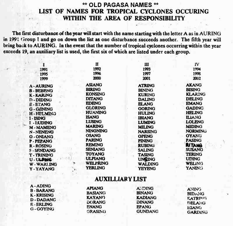
Tropical Storm Ofelia originated from the Western Pacific monsoon trough during July 1993. At 06:00 UTC on July 24, the Joint Typhoon Warning Center (JTWC) started tracking a tropical disturbance, [1] which the Japan Meteorological Agency classified as a tropical depression twelve hours later. [2] [nb 3] [nb 4] Around this time, the Philippine Atmospheric, Geophysical and Astronomical Services Administration (PAGASA) also monitored the storm and assigned it with the local name Luming. [5] At 22:00 UTC, a Tropical Cyclone Formation Alert was issued based on satellite imagery that showed a well-organized system, although the low-level circulation remained exposed from the deep convection. Due to the sudden development of central dense overcast over the low-level circulation center, the JTWC issued its first warning on Tropical Storm Ofelia at 06:00 UTC on July 25, although post-season analysis from the JTWC indicated that Ofelia did not become a tropical storm until three hours later. [1] The JMA followed suit that evening. [6] Tracking west-northwestwards, [7] Ofelia slowly intensified. [8] Midday on July 26, the storm attained its peak intensity of 80 km/h (50 mph) and a minimum barometric pressure of 994 mbar (29.4 inHg). On the next day, the storm made landfall over Kyushu about 60 km (35 mi) east-southeast of Kagoshima [7] at peak intensity. Overland, the storm weakened to a tropical depression later on July 27. [6] After moving across southern Japan, Ofelia recurved northeastwards and became an extratropical cyclone over the Sea of Japan on July 28. [7] The JTWC ceased tracking the system that morning, with the JTWC doing the same a day later. [6]

Impact

Ofelia over Japan on July 27 Ofelia Jul 27 1993 0611Z.png
Ofelia over Japan on July 27

Under the anticipation of landfall over Kyushu, weather alerts were issued for Kyushu and western Honshu, where rains up to 150 mm (5 in) expected. [9] The cyclone, in conjunction with Tropical Storm Nathan before it and Tropical Storm Percy after it, dropped heavy rainfall across southern portions of the Japanese archipelago across late July and early August 1993. [10] [11] [12] A total of 1,282 mm (50.5 in) fell in Ebino; this was the highest rainfall recorded throughout the passage of the three systems combined. [13] A peak hourly rainfall total of 82 mm (3.2 in) was observed by Lake Miike. [14] Meanwhile, a peak daily precipitation total of 637 mm (25.1 in) fell in Asahimaru. [15] A wind gust of 98 km/h (61 mph) was recorded in Kinugasayama. [16] Nation-wide, damage amounted to 21.9 billion yen (US$197 million). [17] [18] [19] [20] [21] Thirteen people were killed by Ofelia. [17] [22] [23] [24]

Across Tokushima Prefecture, 44 homes and 487 roads were damaged while 25 other homes were destroyed. A total of 2,309 ha (5,710 acres) of cops were damaged. Monetary damage there was assessed at 9.82 billion yen. Three people were killed in a landslide near Mount Tsurugi. [17] Across Kochi Prefecture, 142 homes were damaged and an additional 452 were destroyed. Moreover, 622 roads were damaged. Heavy rains contributed to flooding that overflowed rivers in Kochi, Kagami, and Yusuhara, destroying some homes. Throughout the prefecture, three people were killed and another was injured. [22] Two homes were damaged in Kagawa Prefecture. [25] Ofelia dropped heavy rains across Ehime Prefecture for a 36-hour period, resulting in 17 landslides. As a result of the rainfall, 11 trains were delayed and 16 flights were cancelled. Throughout the prefecture, 119 houses were damaged and 10 others were destroyed. Damage totaled 2.87 billion, which was primarily from crops. [18] Four homes were damaged and one was destroyed in Miyazaki Prefecture. [26] Heavy rains from Ofelia, Percy, and Nathan caused Nagasaki City to have their wettest July on record. [27] Three homes were damaged and another was destroyed in Nagasaki Prefecture. [28]

In Oita Prefecture, a landslide triggered by the rain crushed a home in Honyabakei, burying an 87-year old, 57-year-old and 10-year-old. [23] All of the buried were found, two of whom had already perished and another later died in a hospital. [29] Throughout the prefecture, six roads were damaged and there were twenty landslides. [30] Due to a combination of Ofelia and Percy, two homes were damaged in Osaka Prefecture. [31] Twelve homes were damaged in Hyogo Prefecture. [32] Damage in Okayama Prefecture amounted to 789 million yen. [19] Across Hiroshima Prefecture, 18,060 households lost power after 934 power lines were downed while 713 homes were damaged and 54 were destroyed. A total of 22 railtracks and 1,165 roads were damaged. Three people were wounded, including two after a home collapsed. Damage in the prefecture amounted to 8.11 billion yen. [20] Six trains and some road traffic was halted in Yamaguchi Prefecture, located on the western tip of the Honshu. [33] There, four people were killed, including a middle school student who drowned in floodwaters and a 49-year-old that was initially rendered missing, and eight others sustained injuries, three of whom in a tent in Tokuyama. Moreover, 1,312 homes were damaged and 84 others were destroyed; most of the damage and destroyed homes occurred in Ube. [24] Across Shimane Prefecture, 230 homes were damaged and crop damage was estimated at 307 million yen. [21] Due to a combination of Ofelia and Percy, eight homes were damaged in Hokkaido Prefecture. [34]

See also

Notes

  1. All currencies are converted from Japanese yen to United States Dollars using this with an exchange rate of the year 1992.
  2. All damage totals are in 1992 values of their respective currencies.
  3. The Japan Meteorological Agency is the official Regional Specialized Meteorological Center for the western Pacific Ocean. [3]
  4. Wind estimates from the JMA and most other basins throughout the world are sustained over 10 minutes, while estimates from the United States-based Joint Typhoon Warning Center are sustained over 1 minute. 10-minute winds are about 1.14 times the amount of 1-minute winds. [4]

Related Research Articles

<span class="mw-page-title-main">Typhoon Prapiroon (2000)</span> Pacific typhoon in 2000

Typhoon Prapiroon, known in the Philippines as Typhoon Lusing, was the costliest tropical cyclone to strike the Korean Peninsula and the eighth costliest in the West Pacific on record.

<span class="mw-page-title-main">Typhoon Caitlin</span> Pacific typhoon in 1991

Typhoon Caitlin, known in the Philippines as Typhoon Ising, contributed to major drought relief in Okinawa. A tropical disturbance formed in the middle of July 1991 in the eastern portion of the Western Pacific monsoon trough, and while tracking to the west-northwest, was designated a tropical depression on July 21. Thunderstorm activity associated with the depression increased markedly on July 22, and two days later, the depression was upgraded into Tropical Storm Caitlin. The storm turned northward as it rounded a subtropical ridge while gradually intensifying. Caitlin became a typhoon on July 25 and peaked in intensity on July 27 near Okinawa. The typhoon began to weaken as it turned northeast over the Korea Strait. On July 30, Catlin transitioned into an extratropical cyclone as it entered the Sea of Japan.

<span class="mw-page-title-main">Typhoon Cecil (1982)</span> Pacific typhoon in 1982

Typhoon Cecil, known in the Philippines as Typhoon Loleng, was a mid-season tropical cyclone that affected Japan and South Korea during August 1982. An area of disturbed weather formed to the north of Truk on July 31 and tracked westward over the next several days. Following an increase in shower activity and a decrease in wind shear, a tropical depression developed on August 4. Two days later, the depression strengthened into a tropical storm. After turning northwestward and then northward, Cecil intensified into a typhoon on August 7, and then began to deepen at a rapid clip. On August 8, Cecil attained its maximum intensity as it brushed Taiwan. There, 19 people were killed, including 4 in Wugu District, where 2,800 families sought shelter. After pulling away from Taiwan, Typhoon Cecil moved northwestward, and then on August 10, turned to the north-northeast. Colder air, cooler waters, and higher shear contributed to a weakening trend, and Cecil was downgraded to a tropical storm on August 11. Although Cecil passed east of Japan, it came close enough to the country to drop heavy rains. Nation-wide, three people were killed and two were injured. A total of 2,100 households lost power in Hinokage. On August 14, Cecil turned east and struck South Korea as a minimal tropical storm before dissipating over the Sea of Japan. Throughout South Korea, 35 people were killed, 28 went missing, and 28 others sustained injuries. Almost 1,300 houses were flooded, which resulted in 6,200 people becoming homeless. Damage was estimated at US$30 million.

<span class="mw-page-title-main">Tropical Storm Linfa (2003)</span> Pacific severe tropical storm in 2003

Severe Tropical Storm Linfa, known in the Philippines as Tropical Storm Chedeng, brought deadly flooding to areas of the Philippines and Japan in May and June 2003. The fourth named storm within the northwestern Pacific that year, Linfa developed as a tropical depression just off the western coast of Luzon on May 25. The disturbance quickly intensified to reach tropical storm intensity a few hours after cyclogenesis. However, intensification leveled off as Linfa executed a small clockwise loop before a subsequent landfall on Luzon on May 27. Due to land interaction the storm temporarily weakened and decoupled before reforming in the Philippine Sea. Afterwards Linfa began reintensifying and reached its peak intensity on May 29 with maximum sustained winds of 100 km/h (65 mph) and a barometric pressure of 980 mbar. Following its peak the tropical storm began to deteriorate and transitioned into an extratropical cyclone on May 30; these extratropical remnants continued to track northward through Japan before dissipating in the Sea of Okhotsk on June 4.

<span class="mw-page-title-main">Typhoon Flo (1990)</span> Pacific typhoon in 1990

Typhoon Flo, known in the Philippines as Typhoon Norming, was a long-lived typhoon that brought destruction to much of Japan during September 1990. Flo originated from an area of convection that first formed to the southeast of the Marshall Islands on September 7. Five days later, the disturbance obtained tropical depression status, and on September 13, intensified into a tropical storm. Tracking west-northwest as it rounded a subtropical ridge, Flo slowly deepened, and on September 15, became a typhoon. After developing an eye, Flo began to rapidly intensify, and on September 17, Flo attained peak intensity. Shortly thereafter, the typhoon began to recurve to the northeast towards Honshu in response to deepening troughs to the northwest and north of the system, which resulted in a weakening trend due to increased vertical wind shear despite remaining over warm water. On September 19, Flo made landfall on southern Honshu, becoming the first typhoon to hit the Kii Peninsula in 11 years, and thereafter started to transition into an extratropical cyclone. The extratropical remnants of Flo were last noted on the morning of September 22.

<span class="mw-page-title-main">Tropical Storm Luke (1991)</span> Pacific tropical storm in 1991

Tropical Storm Luke, known in the Philippines as Tropical Storm Pepang, was a short-lived tropical storm that brushed Japan during September 1991. Tropical Storm Luke formed from a disturbance that moved through the Northern Marianas and became a tropical depression on September 14 just to the west of the islands. The depression began to slowly intensify as it moved towards the west-northwest and Tropical Storm Luke was named on September 15. Luke reached peak intensity prior to recurving to the northeast and weakening due to increased shear. Tropical Storm Luke then paralleled the southeastern Japan coastline before transitioning into an extratropical cyclone. Overall, 12 people were killed and 23 others were injured. A total of 225 houses were destroyed while 52,662 others were flooded. There were reports of 644 landslides and roads were damaged at 418 locations. Rivers crested at 18 spots and six bridges were washed away. Greater than 40 domestic flights were cancelled. A total of 103 bullet trains were cancelled and 160 others delayed between Tokyo and Osaka, which left 315,000 people stranded. Additionally, 11,999 trains were halted in eastern and northern Japan, stranding 750,000 passengers. Two ships as well as 4,973 ha of farmland were damaged. Monetary damage totaled ¥24.2 billion yen (US$179 million).

<span class="mw-page-title-main">Typhoon Yancy (1993)</span> Pacific typhoon in 1993

Typhoon Yancy, known in the Philippines as Typhoon Tasing, was one of the costliest and most intense tropical cyclones to strike Japan on record. Yancy was the sixth typhoon of the annual typhoon season and sixth tropical cyclone overall to impact Japan that year. Developing out of an area of disturbed weather in the open northwest Pacific on August 29, 1993, the precursor to Yancy tracked westward and quickly intensified to reach tropical storm strength on August 30. Just two days later, the tropical storm reached typhoon intensity as it recurved towards the northeast. A period of rapid intensification followed, allowing Yancy to quickly reach super typhoon intensity. The strong tropical cyclone reached peak intensity on September 2 with maximum sustained winds of 175 km/h (110 mph). The following day Yancy made its first landfall on Iōjima at nearly the same strength; over the course of the day the typhoon would make three subsequent landfalls on Japanese islands. Land interaction forced the tropical cyclone to weaken, and after its final landfall on Hiroshima Prefecture, Yancy weakened below typhoon intensity. After emerging into the Sea of Japan, Yancy transitioned into an extratropical cyclone; these remnants persisted as they meandered in the sea before dissipating completely on September 7.

<span class="mw-page-title-main">Typhoon Orchid (1991)</span> Pacific typhoon in 1991

Typhoon Orchid, known in the Philippines as Typhoon Sendang, was a long-lived typhoon that brushed Japan during October 1991. An area of disturbed weather formed near the Caroline Islands in early October. A mid-latitude cyclone weakened a subtropical ridge to its north, allowing the disturbance to slowly gain latitude, and on October 3, the system organized into a tropical depression. On the next day, the depression intensified into Tropical Storm Orchid. Continuing to intensify, the cyclone strengthened into a typhoon on the morning of October 6. Typhoon Orchid tracked due westward south of subtropical ridge while rapidly intensifying, and on October 7, Orchid reached its peak intensity. Shortly after its peak, the typhoon began to recurve north as the ridge receded. After interacting with Typhoon Pat, Orchid weakened below typhoon intensity on October 12. After accelerating to the northwest while gradually weakening, Orchid transitioned into an extratropical cyclone on October 14.

<span class="mw-page-title-main">Tropical Storm Winona (1990)</span> Pacific tropical storm in 1990

Tropical Storm Winona struck Japan during August 1990. An area of disturbed weather developed within the monsoon trough, located over the East China Sea, on August 4. Despite the presence of strong wind shear, a tropical depression developed later that day. The depression initially tracked northeast, bypassing the southern tip of Kyushu. Thereafter, the depression turned southeast, and on August 6, was believed to have obtained tropical storm intensity. In response to a building subtropical ridge to its southeast, Winona veered north while gradually intensifying. On August 9, Winona peaked in intensity, and while near peak intensity, made landfall in Shizuoka Prefecture early the following morning. Winona transitioned into an extratropical cyclone on August 11, and was last observed on August 14.

<span class="mw-page-title-main">Typhoon Zola</span> Pacific typhoon in 1990

Typhoon Zola struck Japan during August 1990. An area of disturbed weather developed during mid-August to the west of Guam. The disturbance developed into a tropical depression on August 16 while tracking eastward. Decreased wind shear aided in intensification, and it is estimated that the depression strengthened into a tropical storm on August 17. Continuing to intensify, Zola turned northwest in response to a subtropical ridge to its east before obtaining typhoon intensity on August 20. Typhoon Zola reached its peak intensity the next day. After weakening slightly, the storm moved ashore on Honshu. On August 23, the system transitioned into an extratropical cyclone over the Sea of Japan.

<span class="mw-page-title-main">Typhoon Gene</span> Pacific typhoon in 1990

Typhoon Gene, known in the Philippines as Typhoon Oyang, struck Japan during late September 1990. An area of disturbed weather formed several hundred kilometers south-southeast of Okinawa on September 18. Gradual development occurred as it tracked generally westward, and on September 22, the disturbance developed into a tropical depression. The depression intensified into a tropical storm the next day. Continuing to steadily intensify, Gene turned northwest and became a severe tropical storm on September 25. In the evening, Gene was declared a typhoon, and on September 26, attained its maximum intensity. Gene leveled off in intensity while recurving towards Japan. After brushing Kyushu and Shikoku on September 29 and Honshu on September 20, Gene weakened back to a tropical storm. On September 30, Gene transitioned into an extratropical cyclone, which was last noted on October 1.

<span class="mw-page-title-main">Typhoon Hattie</span> Pacific typhoon in 1990

Typhoon Hattie, known in the Philippines as Typhoon Pasing, was the fifth tropical cyclone of a record-six to hit Japan during the 1990 Pacific typhoon season. Hattie originated from an area of disturbed weather that developed within the Western Pacific monsoon trough towards the end of September. Tracking westward, the disturbance initially was slow to develop, although on September 30, the system was classified as a tropical depression. Following an improvement of its convective structure and an increase in associated convection, the depression was upgraded into Tropical Storm Hattie on October 1. Following the development of an eye, Hattie attained typhoon intensity on October 2. The typhoon continued to slowly deepen as its forward speed slowed. Despite a decrease in cloud top temperatures around the eye, Hattie was estimated to have attained peak intensity on October 5. After recurving to the north and then northeast, Hattie began to slowly weaken due to increased wind shear. On October 7, Hattie lost typhoon intensity, and after tracking directly over Tokyo, transitioned into an extratropical cyclone on the next day.

<span class="mw-page-title-main">Typhoon Page</span> Pacific typhoon in 1990

Typhoon Page, known in the Philippines as Typhoon Tering, was the fourth tropical cyclone to strike Japan in three months and the sixth in 1990. An area of disturbed weather developed on November 5 near the International Date Line. For more than two weeks, the disturbance failed to develop appreciably while it tracked generally westward. The disturbance began to organize on November 17. Four days later, the disturbance was designated a tropical depression, and on November 22, the depression was classified as a tropical storm. After resuming a westward course, Page intensified into a typhoon on November 24. Page then entered a period of rapid deepening before plateauing in intensity early on November 26. Page turned northwest, north, and later northeast as it rounded a subtropical ridge. Because of the change in steering, Page began to encounter stronger wind shear, which resulted in a prolonged weakening trend. On November 30, Page, just offshore Honshu, weakened below typhoon intensity, and became an extratropical cyclone on the same day after making landfall in central Honshu.

<span class="mw-page-title-main">Tropical Storm Gladys (1991)</span> Pacific tropical storm in 1991

Tropical Storm Gladys in August 1991 was a large tropical cyclone that affected Japan and South Korea. An area of disturbed weather first formed within the Western Pacific monsoon trough on August 15. Slowly organizing, the disturbance developed into a tropical depression on August 15. Heading northwest, Gladys became a tropical storm the following day. Despite forecasts of significant strengthening, its large size only enabled slow intensification. After turning west, Gladys attained peak intensity on August 21 near Okinawa. After turning north and bypassing Kyushu, Gladys began to encounter significant wind shear, which caused weakening. Gladys veered west, interacting with land. Gladys weakened to a tropical depression on August 24, and dissipated the next day.

<span class="mw-page-title-main">Typhoon Kinna</span> Pacific typhoon in 1991

Typhoon Kinna, known in the Philippines as Typhoon Neneng, was a mid-season typhoon that struck Japan during 1991. An area of disturbed weather formed within the Western Pacific monsoon trough during early September 1991. The disturbance was upgraded into a tropical depression on September 10 after an increase in organization. Tracking northwest due to a weak subtropical ridge to its north, the depression strengthened into a tropical storm at 00:00 UTC on September 11. Later that day, Kinna was upgraded into a severe tropical storm. Following the development of a poorly defined eye, Kinna was upgraded into a typhoon on September 12. The cyclone turned north in response to a trough and passed through Okinawa as a minimal typhoon. Typhoon Kinna obtained peak intensity on September 13, but thereafter, Kinna accelerated north-northeastward toward Kyushu, passing over the island that day at peak intensity. Typhoon Kinna rapidly transitioned into an extratropical low as it tracked along the northern coast of Honshu. Its extratropical remnants were last noted on the evening of September 16. Even though most of the damage occurred on Kyushu and on western Honshu, the typhoon was the most destructive tropical cyclone to strike Okinawa since 1987, and was also the first of typhoon intensity to pass directly over the island since Typhoon Vera in 1986. Nationwide, 11 people were killed and 94 others suffered injuries. Nearly 50,000 customers lost power. Close to 150 domestic flights were cancelled, which left 26,000 travelers stranded. A total of 382 houses were destroyed while 2,586 others were flooded. There were 213 landslides and 9 bridges were washed out. Nearly 70 ships along with 47 roads and 875 ha (2,160 acres) of farmland were damaged. In all, damage was estimated at ¥51.1 billion.

<span class="mw-page-title-main">Tropical Storm Irving (1992)</span> Pacific tropical storm in 1992

Tropical Storm Irving, known in the Philippines as Tropical Depression Edeng, was an early-season tropical cyclone that struck southern Japan during August 1992. A distinct but weak low-pressure area developed within the Western Pacific monsoon trough. A tropical depression formed on July 31, and following an increase in both organization and thunderstorm activity, the depression attained tropical storm intensity on the morning of August 2. After tracking west-northwest and then north, Irving turned to the northeast, and attained peak intensity a day later. In response to a subtropical ridge to the north, the system began to track west-northwestward, and made landfall at maximum intensity over southwestern Shikoku at peak intensity. Irving turned sharply to the west and rapidly weakened, dissipating over the Korea Strait at noon on August 5.

<span class="mw-page-title-main">Typhoon Janis</span> Pacific typhoon in 1992

Typhoon Janis, known in the Philippines as Typhoon Gloring, was an early-season typhoon that struck Japan during August 1992. An area of disturbed weather formed near Pohnpei in late-July 1992, and after an increase in thunderstorm activity, a tropical depression developed on August 3. After passing near Guam, Janis tracked generally westward, and on August 5, the storm was believed to have attained typhoon intensity. After intensifying at a brisk pace, Janis attained peak intensity on August 6 near Okinawa. Thereafter, the typhoon began to weaken and accelerate as it recurved towards Kyushu, where it made landfall on the next day. Land interaction took its toll on the typhoon as it tracked northeast, paralleling the western coast of Honshu. On August 9, Janis transitioned into an extratropical low over Hokkaido.

<span class="mw-page-title-main">Typhoon Kent (1992)</span> Pacific typhoon in 1992

Typhoon Kent was a mid-season typhoon that struck southern Japan during August 1992. An area of convection developed east of the International Date Line. Tracking west-northwestward, a tropical depression developed on August 5, and the next day, intensified into a tropical storm. On August 8, increased vertical wind shear caused convection to decrease, although Kent strengthened into a typhoon on the next day. An eye then appeared as conditions aloft became more conducive, and on August 11, Kent attained its peak intensity. Under the influence of a subtropical ridge located to its north, the typhoon initially continued to move west-northwestward before turning towards Kyushu. The storm steadily weakened prior to making landfall on August 18 just below typhoon intensity. The mountainous terrain of Japan accelerated the weakening trend, and on August 20, Kent dissipated.

<span class="mw-page-title-main">Tropical Storm Percy (1993)</span>

Tropical Storm Percy, known in the Philippines as Tropical Storm Miling, was an early-season tropical cyclone that passed through Japan during July 1993. An area of disturbed weather developed in the Philippine Sea on July 26. Gradual development ensued and on July 27, the disturbance was classified as a tropical depression. The following morning, the depression was upgraded into Tropical Storm Percy. Moving north-northwest, Percy slowly deepened and obtained its peak intensity of 115 km/h (70 mph) and a minimum barometric pressure of 975 mbar (28.79 inHg). Late on July 29, Percy passed over Kyushu and began to weaken. Percy was downgraded to a tropical depression on July 30 and dissipated completely two days later.

<span class="mw-page-title-main">Typhoon Robyn</span> Pacific typhoon in 1993

Typhoon Robyn, known in the Philippines as Typhoon Openg, was a mid-season tropical cyclone that brushed Japan during August 1993. Typhoon Robyn originated from a near equatorial monsoon trough in the eastern Caroline Islands in late July. Tracking west-northwest, a tropical depression developed on August 1, and became a tropical storm the next day. Following an increase in organization, Robyn obtained typhoon intensity on August 5. The typhoon briefly tracked west before veering to the northwest while intensifying. On August 7, Robyn attained its peak intensity of 160 km/h (100 mph), with a barometric pressure of 940 mbar (27.8 inHg). After passing through the Ryukyu Islands, Robyn skirted past western Kyushu on August 9 while steadily weakening. Midday on August 10, Robyn lost typhoon intensity over the Sea of Japan. The next day, the system was declared an extratropical cyclone.

References

  1. 1 2 Joint Typhoon Warning Center; Naval Pacific Meteorology and Oceanography Center (1994). Annual Tropical Cyclone Report: 1992 (PDF) (Report). United States Navy, United States Air Force. Retrieved August 11, 2017.
  2. Japan Meteorological Agency (October 10, 1992). RSMC Best Track Data – 1990–1999 (.TXT) (Report). Retrieved August 11, 2017.
  3. "Annual Report on Activities of the RSMC Tokyo – Typhoon Center 2000" (PDF). Japan Meteorological Agency. February 2001. p. 3. Retrieved August 10, 2017.
  4. Christopher W Landsea; Hurricane Research Division (April 26, 2004). "Subject: D4) What does "maximum sustained wind" mean? How does it relate to gusts in tropical cyclones?". Frequently Asked Questions:. National Oceanic and Atmospheric Administration's Atlantic Oceanographic and Meteorological Laboratory. Retrieved August 10, 2017.
  5. Old PAGASA Names: List of names for tropical cyclones occurring within the Philippine Area of Responsibility 1991–2000. Philippine Atmospheric, Geophysical and Astronomical Services Administration (Report). Typhoon 2000. Retrieved August 11, 2017.
  6. 1 2 3 Kenneth R. Knapp; Michael C. Kruk; David H. Levinson; Howard J. Diamond; Charles J. Neumann (2010). 1993 Severe Tropical Storm OFELIA (1993205N15137). The International Best Track Archive for Climate Stewardship (IBTrACS): Unifying tropical cyclone best track data (Report). Bulletin of the American Meteorological Society. Retrieved August 8, 2017.
  7. 1 2 3 Hong Kong Observatory (1994). "Part III – Tropical Cyclone Summaries". Meteorological Results: 1993 (PDF). Meteorological Results (Report). Hong Kong Observatory. p. 14. Retrieved August 10, 2017.
  8. Typhoon 11W Best Track (TXT) (Report). Joint Typhoon Warning Center. December 17, 2002. Retrieved August 10, 2017.
  9. "Another typhoon may hit Kyushu on Tuesday". Japan Economic Newswire. July 26, 1993.
  10. Asanobu, Kitamoto. Typhoon 199305 (Ofelia). Digital Typhoon (Report). National Institute of Informatics . Retrieved October 1, 2017.
  11. Asanobu, Kitamoto. Typhoon 199306 (Percy). Digital Typhoon (Report). National Institute of Informatics. Retrieved May 8, 2020.
  12. Asanobu, Kitamoto. Typhoon 199304 (Nathan). Digital Typhoon (Report). National Institute of Informatics. Retrieved May 8, 2020.
  13. Asanobu, Kitamoto. AMeDAS EBINO (87346) @ Typhoon 199306. Digital Typhoon (Report). National Institute of Informatics. Retrieved October 1, 2017.
  14. Asanobu, Kitamoto. AMeDAS KIRISHIMAMIIKE (87386) @ Typhoon 199306. Digital Typhoon (Report). National Institute of Informatics. Retrieved October 1, 2017.
  15. Asanobu, Kitamoto. AMeDAS ASAHIMARU (71151) @ Typhoon 199306. Digital Typhoon (Report). National Institute of Informatics. Retrieved October 1, 2017.
  16. Asanobu, Kitamoto. AMeDAS KINUGASAYAMA (84516) @ Typhoon 199306. Digital Typhoon (Report). National Institute of Informatics. Retrieved October 1, 2017.
  17. 1 2 3 Asanobu, Kitamoto. 1993-895-06. Digital Typhoon (Report). National Institute of Informatics. Retrieved June 12, 2020.
  18. 1 2 Asanobu, Kitamoto. 1993-887-15. Digital Typhoon (Report). National Institute of Informatics. Retrieved June 12, 2020.
  19. 1 2 Asanobu, Kitamoto. 1993-768-09. Digital Typhoon (Report). National Institute of Informatics. Retrieved June 22, 2020.
  20. 1 2 Asanobu, Kitamoto. 1993-765-12. Digital Typhoon (Report). National Institute of Informatics. Retrieved June 22, 2020.
  21. 1 2 Asanobu, Kitamoto. 1993-741-08. Digital Typhoon (Report). National Institute of Informatics. Retrieved June 22, 2020.
  22. 1 2 Asanobu, Kitamoto. 1993-893-06. Digital Typhoon (Report). National Institute of Informatics. Retrieved June 12, 2020.
  23. 1 2 "Three killed in typhoon-triggered avalanche of rocks and earth". Agence France Presse. July 28, 1993.
  24. 1 2 Asanobu, Kitamoto. 1993-762-04. Digital Typhoon (Report). National Institute of Informatics. Retrieved June 22, 2020.
  25. Asanobu, Kitamoto. 1993-891-05. Digital Typhoon (Report). National Institute of Informatics. Retrieved June 12, 2020.
  26. Asanobu, Kitamoto. 1993-830-09. Digital Typhoon (Report). National Institute of Informatics. Retrieved June 12, 2020.
  27. Asanobu, Kitamoto. 1993-830-10. Digital Typhoon (Report). National Institute of Informatics. Retrieved June 12, 2020.
  28. Asanobu, Kitamoto. 1993-817-18. Digital Typhoon (Report). National Institute of Informatics. Retrieved June 16, 2020.
  29. "Three people killed in avalanche of rocks and earth". Japanese Economic Newswire. July 28, 1993.
  30. Asanobu, Kitamoto. 1993-815-09. Digital Typhoon (Report). National Institute of Informatics. Retrieved June 16, 2020.
  31. Asanobu, Kitamoto. 1993-772-10. Digital Typhoon (Report). National Institute of Informatics. Retrieved June 16, 2020.
  32. Asanobu, Kitamoto. 1993-770-10. Digital Typhoon (Report). National Institute of Informatics. Retrieved June 16, 2020.
  33. "Weak typhoon to bring downpours in west, north". Japan Economic Newswire. July 27, 1993.
  34. Asanobu, Kitamoto. 1993-430-03. Digital Typhoon (Report). National Institute of Informatics. Retrieved June 22, 2020.