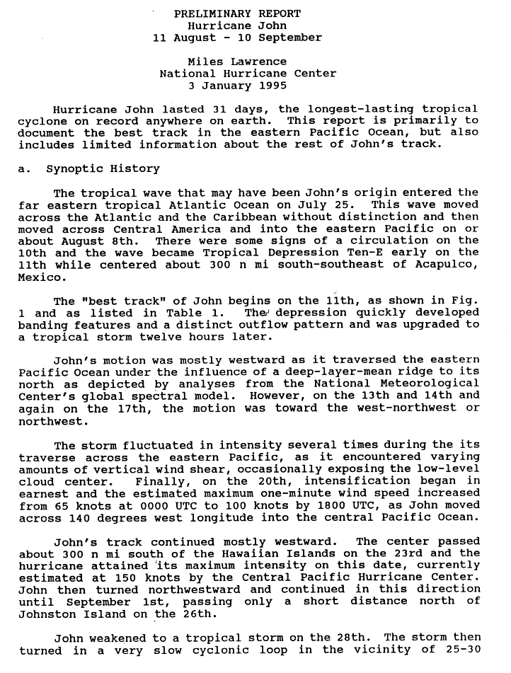
Hurricane John (1994)

Last updated

Map key
  Tropical depression (≤38 mph, ≤62 km/h)
  Tropical storm (39–73 mph, 63–118 km/h)
  Category 1 (74–95 mph, 119–153 km/h)
  Category 2 (96–110 mph, 154–177 km/h)
  Category 3 (111–129 mph, 178–208 km/h)
  Category 4 (130–156 mph, 209–251 km/h)
  Category 5 (≥157 mph, ≥252 km/h)
  Unknown
Storm type
Disc Plain black.svg Tropical cyclone
Solid black.svg Subtropical cyclone
ArrowUp.svg Extratropical cyclone, remnant low, tropical disturbance, or monsoon depression

The origins of Hurricane John were thought by the United States National Hurricane Center (NHC) to be from a tropical wave that moved off the coast of Africa on July 25, 1994. [5] [6] The wave subsequently moved across the Atlantic Ocean and Caribbean without distinction, before it crossed Central America and moved into the Eastern Pacific Ocean on or around August 8. [5] [6] Upon entering the Eastern Pacific the wave gradually developed, before the NHC initiated advisories on the system and designated it as Tropical Depression Ten-E on August 11. [7] The system was at this time moving westwards and located around 345 miles (555 km) to the south-southeast of Acapulco, Mexico. [5] [6] Quickly developing banding features and well-defined outflow, it was upgraded to a tropical storm and named John later that day. [2]

A strong ridge of high pressure over the northeastern Pacific Ocean forced John westward, where upper level wind shear kept John a tropical storm. Intensity fluctuated considerably, however, as shear levels varied. More than once, shear cleared away most of the clouds above John and nearly caused it to weaken to a tropical depression. [2] However, after eight days of slow westward movement across the Pacific Ocean, shear lessened greatly on August 19, and John intensified significantly and was designated as a hurricane at 17:00 PDT. During an eighteen-hour period between August 19 and 20, John further strengthened from a weak Category 1 hurricane to a Category 3 major hurricane. Around 1100 PDT on August 20, John crossed into the central Pacific, the first of three basin crosses John would make. [2]

After entering the central Pacific, John left the area monitored by the NHC and was instead monitored by the Central Pacific Hurricane Center (CPHC). As the storm moved slowly westward, Hurricane John continued to strengthen considerably in an increasingly favorable environment well south of the Hawaiian Islands; on August 22, John was designated a Category 5 hurricane on the Saffir–Simpson hurricane scale (the highest classification for hurricanes) and later that day (by Hawaii Standard Time) reached its peak intensity, with 1-minute sustained winds of 175 miles per hour (280 km/h) and a minimum central pressure of 929 millibars (27.4 inHg). [8] Also, on August 22 (by Hawaii Standard Time), John made its closest approach to the Hawaiian Islands, 345 miles (555 km) to the south. John had threatened to turn north and affect the islands days before, but the ridge of high pressure that typically shields the islands from hurricanes kept John on its southerly path. Nonetheless, heavy rains and wind from the outer bands of John affected the islands. [8]

With the Hawaiian Islands behind it, John began a slow turn to the north, taking near-direct aim at Johnston Atoll, a small group of islands populated only by a United States military base. The storm slowly weakened from its peak as a Category 5 hurricane in the face of increasing shear, dropping down to a Category 1 hurricane with maximum winds of 90 mph (150 km/h). On August 25 local time, John made its closest approach to the Johnston Atoll only 15 miles (24 km) to the north. On Johnston Atoll, sustained winds were reported up to 60 miles per hour (97 km/h), the equivalent of a strong tropical storm, and gusts up to 75 miles per hour (121 km/h) were recorded. [9]

Hurricane John at its tertiary peak strength in the far north-central Pacific Ocean. There is also an extratropical cyclone north of John. Hurricane John Tertiary Peak.jpg
Hurricane John at its tertiary peak strength in the far north-central Pacific Ocean. There is also an extratropical cyclone north of John.

Clearing Johnston Atoll, John turned to the northwest and began strengthening again as shear decreased. On August 27 local time, John reached a secondary peak strength of 130 mph (215 km/h), and shortly thereafter it crossed the International Date Line at approximately 22° N and came under the surveillance of the Guam branch of the Joint Typhoon Warning Center (JTWC). By crossing into the western Pacific, John also became a typhoon and was referred to as Typhoon John during its time in the western Pacific. [9] Immediately after crossing the Date Line, John again weakened and its forward motion stalled. By September 1, John had weakened to a tropical storm and was nearly motionless just west of the Date Line. There, John lingered for six days while performing a multi-day counterclockwise loop. On September 7, a trough moved into the area and quickly moved John to the northeast. John crossed the Date Line again on September 8 and reentered the central Pacific. [9]

After reentering the central Pacific, John briefly reached a tertiary peak strength of 90 mph (150 km/h), a strong Category 1 hurricane, well to the north of Midway Island. However, the trough was rapidly pulling apart John's structure, and the cold waters of the northern central Pacific were not conducive to a tropical cyclone. On September 10, the 120th advisory was released on the system, finally declaring John to have become extratropical approximately 1,000 miles (1,600 km) south of Unalaska Island. [9]

Records

John's 31-day existence made it the longest-lasting tropical cyclone recorded in the Pacific Ocean, surpassing Hurricane Tina's previous record of 24 days in the 1992 season, and the longest-lived globally on record, surpassing the San Ciriaco hurricane's duration of 28 days in the 1899 Atlantic season. [10] John's global record stood until 2023, when it was broken by Cyclone Freddy, which traversed the Indian Ocean in the Southern Hemisphere for 37 days. [11] Additionally, despite its slow movement throughout much of its path, John was also the farthest-traveling tropical cyclone in both the Pacific Ocean and globally, with a distance traveled of 13,180 km (8,190 mi), out-distancing the previous record of 4,700 miles (7,600 km) set by Hurricane Fico in the 1978 season. [3] In addition, John was the first tropical cyclone on record to become a hurricane in the Eastern Pacific (east of 140°W), traverse the entire Central Pacific at hurricane strength, and then cross into the Western Pacific at the International Date Line (180°W) and become a typhoon, a feat matched only by Hurricane Dora in 2023. [12]

Pressure readings from John's peak are not consistently available as the CPHC did not monitor pressures at the time, but Air Force Reserve aircraft did measure a surface pressure of 929 mbar (hPa), making John one of the most intense hurricanes recorded in the central Pacific; both hurricanes Emilia and Gilma of 1994, as well as hurricanes Ioke of 2006 and Lane and Walaka of 2018 all recorded lower pressures in the central Pacific. However, all five had lower wind speeds than John. (Intensity is measured by minimum central pressure, which correlates with but is not directly linked to wind speeds.) John was also only the fourth Category 5 hurricane recorded in the central Pacific (the first was Hurricane Patsy in 1959, the second was Hurricane Emilia and the third one was Hurricane Gilma, both earlier in 1994). John also possessed the highest recorded wind speed in a central Pacific hurricane, 175 mph (280 km/h), a record shared with the aforementioned Patsy of 1959. [8] Since 1994, only three Category 5 hurricanes, Ioke in 2006, and hurricanes Lane and Walaka in 2018 have formed in or entered into the Central Pacific. Despite this however, John's pressure record is incomplete; the 929 millibars (27.43 inHg) reading was only measured when the winds were 160 mph (260 km/h); there is no pressure estimate for when it had winds of 175 mph (280 km/h), so it could have been more intense than Emilia, Gilma, Ioke, Lane, or Walaka. [13]

Impact

Satellite image of Hurricane John as a Category 5 storm with winds of 165 mph (266 km/h) John 1994-08-23 1739Z.jpg
Satellite image of Hurricane John as a Category 5 storm with winds of 165 mph (266 km/h)

John affected both the Hawaiian Islands and Johnston Atoll, but only lightly. While John passed over 345 miles (555 km) to the south of Hawaii, the islands did experience strengthened trade winds and rough surf along the southeast- and south-facing shores, and, while moving westward, on west-facing shores as well. [9] The waves, ranging from 6 to 10 ft (1.8 to 3.0 m) in height, flooded beach parks in Kailua-Kona. [14] Additionally, heavy rains on the Big Island of Hawaiʻi caused minor, localized flooding and some short-term road closures. No deaths, injuries or significant damages were reported in Hawaiʻi. [9]

Although John passed within 25 km (16 mi) of Johnston Atoll, it had weakened greatly to a Category 1 system by closest approach. [9] Prior to the storm's arrival, waves between 20 and 30 ft (6.1 and 9.1 m) were reported on the island. [15] Additionally, in the Northern Hemisphere, the strongest winds and heaviest rain lie to the north of a tropical cyclone, so the atoll, which lay to the south of the storm's path, was spared the brunt of the storm. Nonetheless, the 1,100-man personnel for the United States military base on Johnston Atoll had been evacuated to Honolulu as a precaution while John approached. Damage to structures was considerable, but the size of the island and relative functionality of the base led to low damage; monetary losses were estimated at close to $15 million (1994 US$). [9]

The remnants of John moved through the Aleutian Islands, producing a wind gust of 46 mph (74 km/h) in Unalaska. The storm brought a plume of warm air, and two stations recorded a high temperature of 66 °F (19 °C). [16]

See also

Related Research Articles

<span class="mw-page-title-main">Typhoon Paka</span> Pacific typhoon in 1997

Typhoon Paka, known in the Philippines as Typhoon Rubing, was an extremely powerful and long-lived storm that devastated Guam and the Marshall Islands in December 1997. One of the strongest Pacific typhoons ever recorded in the month of December, Paka was the last tropical cyclone of the 1997 Pacific hurricane and typhoon seasons and the last of a record eleven super typhoons that formed in 1997. Paka, which is the Hawaiian name for Pat, developed on 28 November from a trough well to the southwest of Hawaii. The storm tracked generally westward for much of its duration, and on 7 December it crossed into the western Pacific Ocean. Much of its track was characterized by fluctuations in intensity, and on 10 December the cyclone attained typhoon status as it crossed the Marshall Islands. On 16 December, Paka struck Guam and Rota with winds of 230 km/h (140 mph), and it strengthened further to reach peak winds on 18 December over open waters as the final super typhoon of the year. Subsequently, it underwent a steady weakening trend, and on 23 December Paka dissipated.

<span class="mw-page-title-main">1994 Pacific hurricane season</span> Hurricane season in the Pacific Ocean

The 1994 Pacific hurricane season was the final season of the eastern north Pacific's consecutive active hurricane seasons that started in 1982. The season officially started on May 15, 1994, in the eastern Pacific, and on June 1, 1994, in the central Pacific, and lasted until November 30, 1994. These dates conventionally delimit the period of each year when most tropical cyclones form in the northeastern Pacific Ocean. The first tropical cyclone formed on June 18, while the last system dissipated on October 26. This season, twenty-two tropical cyclones formed in the north Pacific Ocean east of the dateline, with all but two becoming tropical storms or hurricanes. A total of 10 hurricanes occurred, including five major hurricanes. The above average activity in 1994 was attributed to the formation of the 1994–95 El Niño.

<span class="mw-page-title-main">Pacific hurricane</span> Mature tropical cyclone that develops within the eastern and central Pacific Ocean

A Pacific hurricane is a tropical cyclone that develops within the northeastern and central Pacific Ocean to the east of 180°W, north of the equator. For tropical cyclone warning purposes, the northern Pacific is divided into three regions: the eastern, central, and western, while the southern Pacific is divided into 2 sections, the Australian region and the southern Pacific basin between 160°E and 120°W. Identical phenomena in the western north Pacific are called typhoons. This separation between the two basins has a practical convenience, however, as tropical cyclones rarely form in the central north Pacific due to high vertical wind shear, and few cross the dateline.

<span class="mw-page-title-main">1972 Pacific hurricane season</span> Hurricane season in the Pacific Ocean

The 1972 Pacific hurricane season was an ongoing event in tropical cyclone meteorology. There were few notable storms this year. Only one person was killed and storm effects were almost not serious at all. The most notable systems were Hurricane Celeste and Joanne. Celeste was the strongest storm of the season, and caused heavy damage to Johnston Atoll. Hurricane Joanne brought gale-force winds to the Continental United States and caused flooding in Arizona and northern Mexico, which killed one person. The only other system to directly impact land was Hurricane Annette.

<span class="mw-page-title-main">Hurricane Ioke</span> Category 5 Pacific hurricane and typhoon in 2006

Hurricane Ioke, also referred to as Typhoon Ioke, was a record-breaking, long-lived and extremely powerful storm that traversed the Pacific for 17 days, reaching the equivalent of Category 5 status on the Saffir–Simpson hurricane scale on three different occasions. It was the most intense hurricane ever recorded in the Central Pacific, as well as the fifth-most intense Pacific hurricane on record, tied with 1973's Hurricane Ava. It also generated the most accumulated cyclone energy for a single storm, until Cyclone Freddy surpassed its record in 2023. Ioke was the ninth named storm, fifth hurricane, and third major hurricane of the active 2006 Pacific hurricane season.

<span class="mw-page-title-main">Hurricane Dora (1999)</span> Category 4 Pacific hurricane in 1999

Hurricane Dora was one of few tropical cyclones to track across all three north Pacific basins and the first since Hurricane John in 1994. The fourth named storm, third hurricane, and second major hurricane of the 1999 Pacific hurricane season, Dora developed on August 6 from a tropical wave to the south of Mexico. Forming as a tropical depression, the system gradually strengthened and was upgraded to Tropical Storm Dora later that day. Thereafter Dora began heading in a steadily westward direction, before becoming a hurricane on August 8. Amid warm sea surface temperatures and low wind shear, the storm continued to intensify, eventually peaking as a 140 mph (220 km/h) Category 4 hurricane on August 12.

<span class="mw-page-title-main">Tropical cyclone basins</span> Areas of tropical cyclone formation

Traditionally, areas of tropical cyclone formation are divided into seven basins. These include the north Atlantic Ocean, the eastern and western parts of the northern Pacific Ocean, the southwestern Pacific, the southwestern and southeastern Indian Oceans, and the northern Indian Ocean. The western Pacific is the most active and the north Indian the least active. An average of 86 tropical cyclones of tropical storm intensity form annually worldwide, with 47 reaching hurricane/typhoon strength, and 20 becoming intense tropical cyclones, super typhoons, or major hurricanes.

<span class="mw-page-title-main">Hurricane Ava</span> Category 5 Pacific hurricane in 1973

Hurricane Ava was the earliest forming Category 5 hurricane on record in the East Pacific basin. The storm is also tied with 2006's Hurricane Ioke as the fifth-strongest Pacific hurricane on record. It was the first named storm of the 1973 Pacific hurricane season. Forming in early June, Hurricane Ava eventually reached Category 5 intensity on the Saffir–Simpson hurricane scale, the first Pacific hurricane to do so in June and the earliest ever in a season. Its central pressure made it the most intense known Pacific hurricane at the time. Despite its intensity, Ava stayed at sea without significant impact.

<span class="mw-page-title-main">Hurricane Emilia (1994)</span> Category 5 Pacific hurricane in 1994

Hurricane Emilia was, at the time, the strongest tropical cyclone on record in the Central Pacific Ocean, and the second of such to be classified as a Category 5 hurricane – the highest rating on the Saffir–Simpson hurricane wind scale. However, hurricanes Gilma later that year, Ioke in 2006, and hurricanes Lane and Walaka in 2018 later reached lower barometric pressures in the Central Pacific. In addition, Emilia was the first Category 5 Pacific hurricane since Hurricane Ava in 1973. The fifth named storm and the first of three Category 5 hurricanes of the 1994 hurricane season, Emilia developed from an area of low pressure southeast of Hawaii on July 16. Tracking westward, the initial tropical depression intensified into a tropical storm several hours after tropical cyclogenesis. Subsequently, Emilia entered the Central Pacific Ocean and moved into the area of responsibility of the Central Pacific Hurricane Center (CPHC).

<span class="mw-page-title-main">2006 Pacific hurricane season</span> Hurricane season in the Pacific Ocean

The 2006 Pacific hurricane season was the first above-average season since 1997 which produced twenty-five tropical cyclones, with nineteen named storms, though most were rather weak and short-lived. Only eleven hurricanes formed and six major hurricanes. Following the inactivity of the previous seasons, forecasters predicted that season would be only slightly above active. It was also the first time since 2003 in which one cyclone of at least tropical storm intensity made landfall. The season officially began on May 15 in the East Pacific Ocean, and on June 1 in the Central Pacific; they ended on November 30. These dates conventionally delimit the period of each year when most tropical cyclones form in the Pacific basin. However, the formation of tropical cyclones is possible at any time of the year.

<span class="mw-page-title-main">Hurricane Ekeka</span> Category 3 Pacific hurricane in 1992

Hurricane Ekeka was the most intense off-season tropical cyclone on record in the northeastern Pacific basin. The first storm of the 1992 Pacific hurricane season, Ekeka developed on January 28 well to the south of Hawaii. It gradually intensified to reach major hurricane status on February 2, although it subsequently began to weaken due to unfavorable high wind shear. It crossed the International Date Line as a weakened tropical storm, and shortly thereafter degraded to tropical depression status. Ekeka continued westward, passing through the Marshall Islands and later over Chuuk State, before dissipating on February 9 about 310 miles (500 km) off the north coast of Papua New Guinea. The storm did not cause any significant damage or deaths.

<span class="mw-page-title-main">Typhoon Olive (1952)</span> Pacific typhoon in 1952

Typhoon Olive was the strongest Pacific typhoon in 1952. The thirteenth tropical storm and the ninth typhoon of the season, it developed about 1,600 mi (2,600 km) southwest of Honolulu, Hawaii on September 13. The next day, the system attained tropical storm intensity. Beginning to rapidly intensify, Olive attained typhoon intensity on September 15. Olive reached Category 5 intensity on the modern-day Saffir–Simpson hurricane wind scale on September 16.

<span class="mw-page-title-main">Hurricane Uleki</span> Category 3 Pacific hurricane in 1988

Hurricane Uleki, also referred as Typhoon Uleki, was a long-lived tropical cyclone in August–September 1988 that had minimal effects on land. Originating from a disturbance in the Intertropical Convergence Zone in late-August, Uleki was identified as a tropical depression well to the southeast of Hawaii on August 28. Steady organization ensued as it moved west, becoming a tropical storm on August 30 and a hurricane on August 31. Rapid intensification took place thereafter and the storm reached its peak intensity on September 2 as a Category 3 on the Saffir–Simpson hurricane wind scale. hurricane hunters investigating the cyclone found peak winds of 125 mph (201 km/h) and a barometric pressure of 957 mbar. Thereafter, Uleki stalled for two days to the southwest of Hawaii, resulting in heavy surf across the state. The dangerous swells killed two people on Oahu.

<span class="mw-page-title-main">Hurricane Celeste (1972)</span> Category 4 Pacific hurricane in 1972

Hurricane Celeste was the first known tropical cyclone to strike Johnston Atoll as a hurricane. Forming from a disturbance in the East Pacific on August 6, the storm began a general westward movement it would take throughout most of its life. The storm intensified steadily, becoming a Category 1 hurricane on August 10. It kept steady at this intensity until it reached the Central Pacific. Upon entering the Central Pacific, intensification began anew, and by August 14, the hurricane reached a peak intensity of 130 mph (210 km/h). After maintaining this intensity for twelve hours, the hurricane began to weaken while passing south of Hawaii. The weakening phase was similar to its intensification in that the storm lost intensity slowly. Celeste then made a turn to the northwest and dropped below hurricane intensity on August 21. The storm then entered an area of vertical wind shear, causing it to dissipate soon after.

<span class="mw-page-title-main">Hurricane Walaka</span> Category 5 Pacific hurricane in 2018

Hurricane Walaka was a Category 5 hurricane that brought high surf and a powerful storm surge to the Hawaiian Islands. Walaka was the nineteenth named storm, twelfth hurricane, eighth major hurricane, and second Category 5 hurricane of the 2018 Pacific hurricane season.

<span class="mw-page-title-main">Hurricane Kilo</span> Category 4 Pacific hurricane and typhoon in 2015

Hurricane Kilo, also referred to as Typhoon Kilo, was a powerful and long-lived tropical cyclone that traveled more than 4,000 miles (6,400 kilometers) from its formation point southeast of the Hawaiian Islands to its extratropical transition point to the northeast of Japan. Affecting areas from Hawaii to the Russian Far East along its long track, Kilo was the third of a record eight named storms to develop in the North Central Pacific tropical cyclone basin during the 2015 Pacific hurricane season.

<span class="mw-page-title-main">Hurricane Dora (2023)</span> Category 4 Pacific hurricane and typhoon in 2023

Hurricane Dora, also known as Typhoon Dora, was a long‑lived and powerful tropical cyclone that tracked across all three North Pacific tropical cyclone basins in August 2023. The fourth named storm, fourth hurricane, and second major hurricane of the 2023 Pacific hurricane season, Dora developed on July 31, from a tropical wave that had crossed over Central America from the North Atlantic, and became a tropical storm early the following day. During August 2–3, the system rapidly intensified to Category 4 strength. The same day, Dora moved into the Central Pacific basin from the East Pacific basin. Dora's annular structure deteriorated, leaving the system susceptible to dry air intrusions, and the hurricane passed south of Johnston Island. Dora weakened to Category 3 strength on the morning of August 10.

References

  1. "Cold and Warm Episodes by Season". August 4, 2014. Retrieved August 11, 2014.
  2. 1 2 3 4 Lawrence, Miles (1995). "Hurricane John Preliminary Report (page 1)". NOAA . Retrieved May 22, 2006.
  3. 1 2 Dorst, Neal (2004). "What is the farthest a tropical cyclone has traveled?". NOAA Tropical cyclone FAQ. NOAA. Archived from the original on May 6, 2009. Retrieved May 22, 2006.
  4. "Tropical Cyclone: Longest Distance Traveled by Tropical Cyclone". World Meteorological Organization . Retrieved March 9, 2023.
  5. 1 2 3 Lawrence, Miles B (January 3, 1995). Preliminary Report: Hurricane John: August 11 – September 10, 1994 (gif) (Report). United States National Hurricane Center. p. 1. Archived from the original on October 29, 2013. Retrieved August 11, 2014.
  6. 1 2 3 Mayfield, Britt Max; Pasch, Richard J (1996). "Eastern North Pacific Hurricane Season of 1994". Monthly Weather Review. American Meteorological Society. 124 (7): 1585–1586. Bibcode:1996MWRv..124.1579P. doi: 10.1175/1520-0493(1996)124<1579:ENPHSO>2.0.CO;2 .
  7. Lawrence, Miles B (August 11, 1994). Tropical Depression Ten-E Discussion Number 1: August 11, 1994 09z (Report). United States National Hurricane Center. Archived from the original on August 12, 2014. Retrieved August 11, 2014.
  8. 1 2 3 Lawrence, Miles (1995). "Hurricane John Preliminary Report (page 2)". NOAA . Retrieved May 23, 2006.
  9. 1 2 3 4 5 6 7 8 Central Pacific Hurricane Center (2004). "Hurricane John Preliminary Report" (PDF). NOAA . Retrieved May 24, 2006. (Note that this report does not reflect changes made in post-season analysis.)
  10. Dorst, Neal (2004). "Which tropical cyclone lasted the longest?". NOAA Tropical cyclone FAQ. NOAA. Archived from the original on September 24, 2008. Retrieved May 22, 2006.
  11. Cappucci, Matthew (March 7, 2023). "Deadly cyclone Freddy has become Earth's longest-lived tropical storm". The Washington Post. Archived from the original on March 7, 2023. Retrieved March 7, 2023.
  12. Barker, Aaron; Oberholtz, Chris (August 11, 2023). "Dora to become 2nd hurricane-strength storm to be in Eastern, Central and Western Pacific Ocean". FOX Weather. Retrieved August 11, 2023.
  13. National Hurricane Center; Hurricane Research Division; Central Pacific Hurricane Center (April 4, 2023). "The Northeast and North Central Pacific hurricane database 1949–2022". United States National Oceanic and Atmospheric Administration's National Weather Service. A guide on how to read the database is available here. PD-icon.svg This article incorporates text from this source, which is in the public domain.
  14. National Climatic Data Center (1994). "Event Report for Hawaii". Archived from the original on January 12, 2012. Retrieved May 28, 2006.
  15. Staff Writer (August 26, 1994). "Island braces for Hurricane John". Gainesville Sun. p. 4. Retrieved December 12, 2009.
  16. "A Composite of Outstanding Storms" (PDF). Storm Data. 36 (9): 60. September 1994. Archived from the original (PDF) on August 14, 2014. Retrieved April 22, 2012.
Hurricane John
John 1994-08-23 0200Z.png
John near peak intensity to the south of Hawaii on August 23