Hurricane Kenna

Last updated

Map key
  Tropical depression (≤38 mph, ≤62 km/h)
  Tropical storm (39–73 mph, 63–118 km/h)
  Category 1 (74–95 mph, 119–153 km/h)
  Category 2 (96–110 mph, 154–177 km/h)
  Category 3 (111–129 mph, 178–208 km/h)
  Category 4 (130–156 mph, 209–251 km/h)
  Category 5 (≥157 mph, ≥252 km/h)
  Unknown
Storm type
Disc Plain black.svg Tropical cyclone
Solid black.svg Subtropical cyclone
ArrowUp.svg Extratropical cyclone, remnant low, tropical disturbance, or monsoon depression

The origin of Hurricane Kenna can be traced to a tropical wave moving westward through the Caribbean Sea on October 16, possibly the same wave that passed near Barbados two days earlier. The wave entered the eastern Pacific Ocean on October 19, and a tropical disturbance along the wave axis gradually became better organized. Conditions favored continued development, and Dvorak classifications began late on October 20. Early on October 22, the system developed into Tropical Depression Fourteen-E while located about 375 mi (604 km) south of Manzanillo, Colima. [1] Initially the depression was disorganized, with little inner convective structure and sporadic deep convection. Computer models predicted an increase in wind shear by 60 hours; as such the National Hurricane Center forecast the depression to strengthen to a peak strength of 45 mph (72 km/h) before weakening. [2]

The depression quickly became better organized with a great increase in convection near the center, and six hours after forming it strengthened into Tropical Storm Kenna. Upper-level outflow and banding features improved in an organization, as well. With warm water temperatures of over 29 °C (84 °F) and updated model forecasts anticipating light amounts of vertical wind shear, forecasters predicted Kenna to slowly intensify to reach winds of 85 mph (137 km/h) within 72 hours of October 22. [3] The storm moved to the west-northwest around the periphery of a mid-level high-pressure system, and initially failed to strengthen further with much of its convection being associated with outer rainbands. On October 23, the outer rainbands dissipated and convection became more concentrated near the center, which coincided with a steady increase in strength. Late on October 23, Kenna intensified into a hurricane while located about 380 mi (610 km) southwest of Manzanillo. [1]

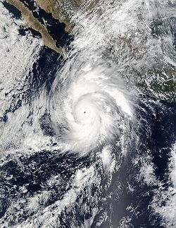
Shortly after becoming a hurricane, Kenna began to rapidly intensify with a 17 mi (27 km) wide eye located within its well-defined central dense overcast. [4] Early on October 24 Kenna became a major hurricane, and in a 24‑hour period the hurricane more than doubled its windspeed from 70 mph (110 km/h) winds to 145 mph (233 km/h). After turning to the north and northeast in response to the flow ahead of a large mid to upper-level trough, Kenna attained peak winds of 165 mph (270 km/h) early on October 25 while located about 255 mi (410 km) southwest of Puerto Vallarta, the third Category 5 hurricane of the season. A Hurricane Hunter flight into the hurricane while it was near peak intensity recorded a pressure of 913  mbar (hPa), [1] the fourth lowest recorded pressure for a Pacific hurricane. [5] [6]

Quickly after peaking, wind shear from the approaching trough weakened the hurricane, and by six hours after reaching peak intensity, the winds in Hurricane Kenna dropped to 150 mph (240 km/h), after the eye nearly dissipated. Despite a 27  mbar increase in pressure in 12 hours, convective activity increased prior to Kenna making landfall. On October 25, Hurricane Kenna made landfall near San Blas in the state of Nayarit, as a Category 4 hurricane, with estimated sustained winds of 140 mph (220 km/h). Hurricane Kenna was at the time, the third most intense Pacific hurricane to strike Mexico. The hurricane rapidly weakened over the mountainous terrain of western Mexico, and the circulation dissipated on October 26 over the Sierra Madre Occidental mountains. The remnants continued northeastward into the Gulf of Mexico and the southeastern United States later that day, producing rainfall across the region. [1]

Preparations

Hurricane Kenna rainfall in Mexico Kenna rainfall.JPG
Hurricane Kenna rainfall in Mexico

About 27 hours before landfall, Mexican officials issued a hurricane watch from Mazatlán to Cabo Corrientes, Jalisco, with a tropical storm watch issued further south to Manzanillo. Six hours later when its track became more apparent, the watch was upgraded to a hurricane warning from Mazatlán to La Fortuna, with a tropical storm warning southward to Manzanillo. [1]

Roughly 8,800 of the 9,000 residents in the landfall location, San Blas, evacuated, which ultimately contributed to a low death toll. [1] Officials ordered for the evacuation of 50,000 residents and fishermen along the southwest coast of Mexico, including 3,000 in the Islas Marías, [7] 10,000 near Mazatlán, and 15,000 near flood-prone areas. Civil authorities closed all schools and docks in potentially affected areas. The Mexican Red Cross prepared for the storm by shipping 215  tonnes of relief supplies such as food, water, clothing, and medicine to the Red Cross branch in Jalisco. Assistance from the Yucatán Peninsula delivered 10  tonnes of food and water, as well. [8] The Mexican Red Cross prepared 20 emergency shelters in the state of Nayarit. [9] Officials took security measures in Los Cabos, Baja California Sur, where the Asia-Pacific Economic Cooperation was meeting during the passage of the hurricane. Early forecasts indicated a possible threat to the meeting, causing the government to prepare for a potential alternate site. [7] Officials recommended boats to stay at port due to severe conditions. [10]

Impact

Hurricane Kenna
Hurricane Kenna 24 oct 2002 1750Z.jpg
Kenna near peak intensity on October 24
Pacific hurricanes with a wind speed of 140 mph (220 km/h) or higher at landfall
HurricaneSeasonWind speedRef.
Otis 2023 160  mph (260  km/h) [11]
Patricia 2015 150 mph (240 km/h) [12]
Madeline 1976 145 mph (230 km/h) [13]
Iniki 1992 [14]
Twelve 1957 140 mph (220 km/h) [15]
"Mexico" 1959 [15]
Kenna 2002 [16]
Lidia 2023 [17]
Hurricane Kenna making landfall in Mexico on October 25 Hurricane Kenna 25 oct 2002.jpg
Hurricane Kenna making landfall in Mexico on October 25

Few official surface observations are available for the passage of the hurricane. Upon making landfall, Kenna was accompanied with an estimated 16 feet (4.9 m) storm surge in San Blas. The surge also affected Puerto Vallarta, with reports of 10 feet (3.0 m) waves rushing inland from the bay. The hurricane dropped about 1.38 inches (35 mm) of precipitation while passing about 60 mi (97 km) east of the offshore archipelago, Islas Marías. There, sustained winds reached an estimated 106 mph (171 km/h). [1] On land, Kenna dropped heavy rainfall peaking at 18.91 inches (480 mm) at San Ignacio, Sinaloa, and 12.89 inches (327 mm) near Manzanillo, Colima. [18] The highest recorded sustained wind on land was about 100 mph (160 km/h) at Tepic, Nayarit, with wind gusts at Puerto Vallarta reaching 50 mph (80 km/h). [1] The hurricane also produced heavy rainfall in Guerrero, Michoacán, Colima, and Jalisco, and hit Baja California Sur with strong winds and rough seas. [10]

In San Blas, strong winds from the hurricane damaged or destroyed 95% of the homes, [19] with 1,540 houses damaged and 8,800 people affected. [20] There, large commercial shrimp boats were swept up to 900 feet (270 m) inland from their docks. An elderly woman died in the city when the wall of her house collapsed on her. [1] Large portions of the city were covered with building debris and sand washed from the ocean. [8] Elsewhere in Nayarit, flying debris killed a person in Santiago Escuintla. There, two elderly men drowned, one by falling into a river. Both were believed to have been killed during the storm as they fled their homes. [1] In Santiago Ixcuintla, the hurricane damaged 3,770 homes, [20] and throughout Nayarit, strong winds from the hurricane destroyed the roofs of hundreds of houses. [21] Federal authorities lost communications with at least 30 Indian villages due to the high winds of the hurricane. [8] Kenna destroyed the entire banana, tobacco, and tomato crops in the rural areas of San Blas, Tecuala, and Acaponeta, leaving more than 700 subsistence farmers and their families in need of water and food. [20]

In Puerto Vallarta, about 100 mi (160 km) southeast of the landfall location, the storm surge resulted in an estimated damage total of US$5 million, primarily to hotels. [1] The surge flooded the hotels and other waterfront areas, and extended up to 330 feet (100 m) inland. Waist-deep floodwaters swept away vans and cars, [22] ruining several vehicles. The passage of the hurricane destroyed 150 stores near the ocean and extensively damaged three hotels. Damage to the city's port was minor. [23]

The hurricane injured at least 52 in Puerto Vallarta [24] and dozens in San Blas from widespread flying glass and other forms of debris, [1] with two people seriously injured due to the hurricane. Ten municipalities suffered substantial damage, [23] with insured damage in Mexico totaling

The remnants of Kenna entered the south-central United States on October 26, resulting in enhanced rainfall in various locations. [1]

Aftermath

Damage in Puerto Vallarta Kenna damage (Vallarta).jpg
Damage in Puerto Vallarta

The Mexican government declared the region in Nayarit near the landfall of Kenna as a disaster area, allowing for the usage of emergency funds. [8] Immediately after the passage of the hurricane, the Mexican Red Cross prepared 180 technical staff and volunteers from seven states to deliver 125  MT of food, medicine, and clothes to the areas most affected. [21] The Mexican government deployed the Mexican Army to the area to remove fallen trees and establish water treatment plants to assist the affected population. The Mexican Navy was sent to assist to support medical personnel in the San Blas area, and the government Department for Family Development assisted the Mexican Red Cross in delivering food. Grupo Modelo, brewers of Corona beer, sent 6,600  gallons (25,000 liters) of drinking water and 1000 food sets for the San Blas area. [20]

Backhoes and dump trucks gradually removed the debris and sand from San Blas. [8] Dozens of storeowners, municipal employees, and volunteers in Puerto Vallarta worked to clear the debris caused by the storm. The remaining stores, bars, and shops placed signs on their windows describing they were open in an effort to attract the tourists still in the town. [23] By about two months after the hurricane, most hotels, restaurants, and shops were reopened. [26]

Retirement

In the spring of 2003, the World Meteorological Organization retired the name Kenna from its rotating eastern Pacific name lists due to the deaths and damage this hurricane caused, and it will never be used again for another tropical cyclone. Kenna was replaced with Karina for the 2008 season. [27] [28]

See also

Related Research Articles

<span class="mw-page-title-main">2003 Pacific hurricane season</span> Hurricane season in the Pacific Ocean

The 2003 Pacific hurricane season was the first season to feature no major hurricanes since 1977. The season officially began on May 15, 2003 in the Eastern North Pacific, and on June 1 in the Central ; both ended on November 30. These dates, adopted by convention, historically describe the period in each year when most tropical cyclogenesis occurs in these regions of the Pacific. The season featured 16 tropical storms, 7 of which intensified into hurricanes, which was then considered an average season. Damage across the basin reached US$129 million, and 23 people were killed by the storms.

<span class="mw-page-title-main">2002 Pacific hurricane season</span> Hurricane season in the Pacific Ocean

The 2002 Pacific hurricane season was a near–average season which produced fifteen named storms. Eight hurricanes formed, including a record-equaling three Category 5 hurricanes, a record it shares with the 1994 and 2018 seasons. It was also a near-average season in terms of accumulated cyclone energy (ACE), having an ACE of 125. The season officially began on May 15, 2002 in the East Pacific Ocean, and on June 1, 2002 in the Central Pacific; both ended on November 30. These dates conventionally delimit the period of each year when most tropical cyclone formation occurs in these regions of the Pacific. The first system of the 2002 season, Hurricane Alma, formed on May 24, and the last, Tropical Depression Sixteen-E, dissipated on November 16.

<span class="mw-page-title-main">1996 Pacific hurricane season</span> Hurricane season in the Pacific Ocean

The 1996 Pacific hurricane season had below normal tropical cyclone activity, producing 9 tropical storms, of which 5 became hurricanes, with 2 of those intensifying into major hurricanes. With an Accumulated cyclone energy (ACE) index of 53.9, the season ranks among the least intense Pacific hurricane seasons on record. It officially began May 15, 1996, in the eastern north Pacific and on June 1, 1996, in the central north Pacific. It ended on November 30, 1996. These dates conventionally delimit the period of each year when most tropical cyclones form in the northeastern Pacific Ocean. The season slightly exceeded these bounds when tropical storm One-E formed on May 13.

<span class="mw-page-title-main">1992 Pacific hurricane season</span> Hurricane season in the Pacific Ocean

The 1992 Pacific hurricane season is the most active Pacific hurricane season on record, featuring 27 named storms. The season also produced the second-highest ACE value on record in the basin, only surpassed by the 2018 season. The 1992 season officially started on May 15 in the eastern Pacific, and on June 1 in the central Pacific, and lasted until November 30. These dates conventionally delimit the period of each year when most tropical cyclones form in the northeastern Pacific Ocean. However, tropical cyclogenesis is possible at any time of the year, as demonstrated by the development of Hurricane Ekeka on January 28, and Tropical Storm Hali two months later.

<span class="mw-page-title-main">Hurricane Calvin (1993)</span> Category 2 Pacific hurricane in 1993

Hurricane Calvin was one of three Pacific hurricanes on record to make landfall along the Mexican coast during the month of July. The fourth tropical cyclone, third named storm, and second hurricane of the 1993 Pacific hurricane season, Calvin developed from an area of convection to the south of Mexico on July 4. The following day, the system intensified into a tropical storm, which was named Calvin. Continued strengthening ensued as Calvin curved from its initial westward track northward, and was upgraded to a hurricane on July 6. Calvin eventually turned northwest, and became a Category 2 hurricane on the Saffir–Simpson hurricane wind scale (SSHWS). By July 7, Hurricane Calvin made landfall near Manzanillo at peak strength. Calvin rapidly weakened after landfall, and was a tropical storm when it reemerged into the Pacific Ocean on early on July 8. Despite this, the hurricane did not reintensify, and continued to weaken as it headed rapidly northwestward. As Calvin made a second Mexican landfall near the southern tip of Baja California peninsula late on July 8, it weakened to a tropical depression. Early on July 9, the depression dissipated shortly after entering the Pacific Ocean for a third time.

<span class="mw-page-title-main">Hurricane Madeline (1998)</span> Category 1 Pacific hurricane in 1998

Hurricane Madeline was a costly tropical cyclone whose remnants caused hundreds of millions of dollars in damage in Texas in October 1998. The final tropical cyclone of the 1998 Pacific hurricane season, Madeline originated from a tropical wave that emerged off the coast of Africa on September 25, 1998. The wave traversed the Atlantic Ocean and crossed over Central America on October 5 or 6. Gradually, the system intensified and was classified as a tropical depression on October 16, a tropical storm later that day, and a hurricane on October 17. The storm reached peak winds of 85 mph (137 km/h) about 95 miles (153 km) southwest of San Blas, Nayarit, and after 18 hours it subsequently began to weaken. Although Madeline never made landfall, numerous rainbands affected the Mexican coast causing no known damage or fatalities. The remnant moisture moved north and contributed to flooding in central Texas, which killed 31 people and caused $750 million in damage.

<span class="mw-page-title-main">Hurricane Hernan (1996)</span> Category 1 Pacific hurricane in 1996

Hurricane Hernan was fourth and final tropical cyclone to strike Mexico at hurricane intensity during the 1996 Pacific hurricane season. The thirteenth tropical cyclone, eighth named storm, and fifth hurricane of the season, Hernan developed as a tropical depression from a tropical wave to the south of Mexico on September 30. The depression quickly strengthened, and became Tropical Storm Hernan later that day. Hernan curved north-northwestward the following day, before eventually turning north-northeastward. Still offshore of the Mexican coast on October 2, Hernan intensified into a hurricane. Six hours later, Hernan attained its peak as an 85 mph (140 km/h) Category 1 hurricane on the Saffir-Simpson Hurricane Wind Scale (SSHWS). After weakening somewhat, on 1000 UTC October 3, Hurricane Hernan made landfall near Barra de Navidad, Jalisco, with winds of 75 mph (120 km/h). Only two hours after landfall, Hernan weakened to a tropical storm. By October 4, Tropical Storm Hernan had weakened into a tropical depression, and dissipated over Nayarit on the following day.

<span class="mw-page-title-main">Hurricane Olaf (2003)</span> Category 1 Pacific hurricane in 2003

Hurricane Olaf was a minimal hurricane that impacted Mexico in October 2003. The fifteenth named storm and sixth hurricane of the annual season, Olaf formed from a tropical wave became better organized on October 2 to the south-southeast of Acapulco and developed into a depression the next day. It strengthened into Tropical Storm Olaf six hours after forming. Continued intensification occurred, and Olaf reached its peak strength as a Category 1 hurricane with 75 mph (120 km/h) winds on October 5 and developed a partial eyewall. The storm soon became disorganized and was only a hurricane for six hours, before re-curving towards the Mexican coast. The cyclone made landfall near Manzanillo, Colima, on October 7 and soon dissipated overland. The storm caused severe flooding in the states of Jalisco and Guanajuato. However, no fatalities were reported.

<span class="mw-page-title-main">Hurricane Henriette (1995)</span> Category 2 Pacific hurricane in 1995

Hurricane Henriette was the ninth tropical cyclone, eight named storm and fifth hurricane of the 1995 Pacific hurricane season. Henriette developed from a tropical wave that emerged from the west coast of Africa on August 15. After crossing the Atlantic and moving into the eastern Pacific on August 29, it developed a low-level circulation that was designated a tropical depression on September 1. The next day, the depression was upgraded to Tropical Storm Henriette, and it was further upgraded to a hurricane on September 3. The storm peaked as a Category 2 hurricane on the Saffir-Simpson Hurricane Scale, and crossed the southern tip of Baja California Peninsula. On land, wind gusts of 100 mph (160 km/h) were reported, knocking out power and water supplies. Heavy rainfall and strong storm surge contributed to flooding that damaged many roads; throughout the region, 800 people were forced from their homes.

<span class="mw-page-title-main">2013 Pacific hurricane season</span> Hurricane season in the Pacific Ocean

The 2013 Pacific hurricane season was an above average Pacific hurricane season with 21 tropical cyclones forming. Of these, 20 became named storms – 18 in the Eastern Pacific basin, and 2 in the Central Pacific basin. Of the 18 named storms in the east, 9 became hurricanes, with one, Raymond, becoming the season's only major hurricane. In the central, neither named storm became a hurricane. It was also a below-normal season in terms of Accumulated cyclone energy (ACE), as many of its systems were weak and short-lived. The season officially began on May 15 in the Eastern Pacific and started on June 1 in the Central Pacific; both ended on November 30. These dates conventionally delimit the period of each year when most tropical development occurs in these North Pacific basins. The first cyclone, Tropical Storm Alvin, formed on May 15, and the last, Tropical Storm Sonia, dissipated on November 4.

<span class="mw-page-title-main">Timeline of the 2010 Pacific hurricane season</span>

The 2010 Pacific hurricane season was one of the least active seasons on record, featuring the fewest named storms since 1977. The season officially started on May 15 in the eastern Pacific—east of 140°W—and on June 1 in the central Pacific—between the International Date Line and 140°W—and lasted until November 30. These dates typically cover the period of each year when most tropical cyclones form in the eastern Pacific basin. The season's first storm, Tropical Storm Agatha, developed on May 29; the season's final storm, Tropical Storm Omeka, degenerated on December 21.

<span class="mw-page-title-main">Hurricane Jova (2011)</span> Category 3 Pacific hurricane in 2011

Hurricane Jova was a powerful Category 3 Pacific hurricane that made landfall on southwestern Mexico in October 2011. The tenth named storm, ninth hurricane and fifth major hurricane of the 2011 Pacific hurricane season, Jova developed from a tropical disturbance that initially formed on October 5, 2011. The disturbance steadily organized and acquired more thunderstorm activity over the following hours, and it became a tropical depression early on October 6. The depression strengthened into Tropical Storm Jova later that day. Moving generally northward, wind shear initially inhibited Jova from strengthening much until the establishment of more favorable conditions on October 8 allowed Jova to begin to intensify. It reached hurricane strength that day as it drifted eastwards, and major hurricane status on October 10 after a period of steady intensification. Jova reached peak intensity the following day as a high-end Category 3 hurricane, with maximum sustained winds of 125 mph (205 km/h), and a minimum barometric pressure of 955 mbar (28.20 inHg). Jova weakened somewhat as it approached the Pacific coast of Mexico, and made landfall near Barra de Navidad, Jalisco on October 12 as a still-powerful Category 2 hurricane. The storm rapidly weakened as it moved inland and dissipated later that day.

<span class="mw-page-title-main">Timeline of the 2012 Pacific hurricane season</span>

The 2012 Pacific hurricane season was an above-average year in which seventeen named storms formed. The hurricane season officially began on May 15 in the east Pacific—defined as the region east of 140°W—and on June 1 in the central Pacific—defined as the region west of 140°W to the International Date Line—and ended on November 30 in both regions. These dates conventionally delimit the period during each year when most tropical cyclones form in the northeastern Pacific Ocean. This year, the first storm of the season, Tropical Storm Aletta, formed on May 14, and the last, Tropical Storm Rosa, dissipated on November 3.

<span class="mw-page-title-main">Hurricane Bud (2012)</span> Category 3 Pacific hurricane in 2012

Hurricane Bud was a rare May major hurricane that skirted areas of the western Mexican coast. The second tropical cyclone and named storm of the 2012 Pacific hurricane season, Bud developed slowly into a tropical depression from a low-pressure area, centered well south of Mexico on May 20. It moved generally west-northwestward and by the following day, strengthened into Tropical Storm Bud. Thereafter, further intensification was slow. By late on May 23, Bud reached winds of 65 mph (105 km/h). On the following day, however, rapid deepening commenced, with the storm becoming a hurricane on that day. Bud peaked as a 115 mph (185 km/h) Category 3 hurricane on May 25. Several hours after reaching that intensity, the storm began to quickly weaken as it moved near Western Mexico. Bud continued to weaken, eventually dissipating the next day.

<span class="mw-page-title-main">Timeline of the 2013 Pacific hurricane season</span>

The 2013 Pacific hurricane season was an above-average year in which twenty named storms developed. The hurricane season officially began on May 15 in the East Pacific, coinciding with the formation of Tropical Storm Alvin, and on June 1 in the Central Pacific; it ended on November 30 in both basins. These dates conventionally delimit the period during each year when most tropical cyclones form. The final system of the year, Tropical Storm Sonia, dissipated on November 4.

<span class="mw-page-title-main">2018 Pacific hurricane season</span> Hurricane season in the Pacific Ocean

The 2018 Pacific hurricane season was one of the most active Pacific hurricane seasons on record, producing the highest accumulated cyclone energy value on record in the basin. The season had the fourth-highest number of named storms – 23, tied with 1982. The season also featured eight landfalls, six of which occurred in Mexico. The season officially began on May 15 in the Eastern Pacific, and on June 1 in the Central Pacific; they both ended on November 30. These dates conventionally delimit the period of each year when most tropical cyclones form in the Pacific basin. However, tropical cyclone formation is possible at any time of the year, as illustrated when the first tropical depression formed on May 10, five days prior to the official start of the season.

<span class="mw-page-title-main">2022 Pacific hurricane season</span> Hurricane season in the Pacific Ocean

The 2022 Pacific hurricane season was an above average hurricane season in the eastern North Pacific basin, with nineteen named storms, ten hurricanes, and four major hurricanes. Two of the storms crossed into the basin from the Atlantic. In the central North Pacific basin, no tropical cyclones formed. The season officially began on May 15 in the eastern Pacific, and on June 1 in the central; both ended on November 30. These dates historically describe the period each year when most tropical cyclogenesis occurs in these regions of the Pacific and are adopted by convention.

<span class="mw-page-title-main">Hurricane Orlene (2022)</span> Category 4 Pacific hurricane in 2022

Hurricane Orlene was a powerful tropical cyclone that caused minor damage to the Pacific coast of Mexico in October 2022. The cyclone was the sixteenth named storm, ninth hurricane, and third major hurricane of the 2022 Pacific hurricane season. Orlene originated from a low-pressure area off the coast of Mexico. Moving towards the north, Orlene gradually strengthened, becoming a hurricane on October 1 and reaching its peak intensity the following day with winds of 130 mph (215 km/h). Orlene made landfall just north of the Nayarit and Sinaloa border, with winds of 85 mph (140 km/h). Soon afterward, Orlene rapidly weakened and became a tropical depression, eventually dissipating over the Sierra Madre Occidental late on October 4.

<span class="mw-page-title-main">Hurricane Roslyn (2022)</span> Category 4 Pacific hurricane in 2022

Hurricane Roslyn was a powerful tropical cyclone that struck the Pacific coast of Mexico in October 2022. The nineteenth named storm, tenth hurricane, and fourth major hurricane of the 2022 Pacific hurricane season, Roslyn formed on October 20, from an area of low pressure that developed off the southwestern coast of Mexico. The system moved west-northwestward, paralleling the coast, where it became a hurricane at 00:00 UTC, on October 22, and, within 18 hours rapidly intensified to a Category 4 hurricane, with sustained winds of 130 mph (215 km/h). Roslyn made landfall on October 23 near Santa Cruz in northern Nayarit, at 11:20 UTC with 120 mph (195 km/h) winds. Inland, Roslyn weakened quickly to a tropical storm, and then dissipated over east-central Mexico on October 24.

<span class="mw-page-title-main">Hurricane Lidia (2023)</span> Category 4 Pacific hurricane in 2023

Hurricane Lidia was a powerful Category 4 Pacific hurricane that was one of four tropical cyclones to make landfall on the Pacific Coast of Mexico in October 2023. The fifteenth tropical depression, twelfth named storm, eighth hurricane and sixth major hurricane of the 2023 Pacific hurricane season, Lidia originated from a disturbance that developed to the south of Mexico in late September 2023. The disturbance developed into a tropical storm on October 3, and was given the name Lidia. Lidia initially meandered off the coast of Mexico for several days as a moderate tropical storm, while moving gradually northward. Lidia first turned northwestward before embarking on a northeastward course on October 9, at which time the storm began a phase of rapid intensification. Early on October 10, Lidia became a hurricane, and the storm continued to quickly intensify, reaching its peak intensity as a Category 4 hurricane late that day with sustained winds of 140 mph (220 km/h). Lidia made landfall shortly afterwards at peak intensity, making it the third-strongest landfalling Pacific hurricane on record at the time. Lidia rapidly weakened over the mountainous terrain of Mexico and dissipated the following morning over the inland state of Zacatecas.

References

  1. 1 2 3 4 5 6 7 8 9 10 11 12 13 14 Franklin, James L (December 26, 2002). Hurricane Kenna 2002 (PDF) (Tropical Cyclone Report). United States National Oceanic and Atmospheric Administration's National Weather Service. Retrieved May 26, 2012.
  2. Lawrence, Miles B.; National Hurricane Center (October 21, 2002). "Tropical Depression Fourteen-E Discussion One". United States National Oceanic and Atmospheric Administration's National Weather Service. Retrieved May 26, 2012.
  3. Stewart, Stacy; National Hurricane Center (October 22, 2002). "Tropical Storm Kenna Discussion Two". United States National Oceanic and Atmospheric Administration's National Weather Service. Retrieved May 26, 2012.
  4. Beven II, Jack L.; National Hurricane Center (2002). "Hurricane Kenna Discussion Nine". United States National Oceanic and Atmospheric Administration's National Weather Service. Retrieved May 26, 2012.
  5. Lawrence, Miles B.; Mainelli, Michelle M.; National Hurricane Center (November 30, 2001). Hurricane Kenna 2002 (Tropical Cyclone Report). United States National Oceanic and Atmospheric Administration's National Weather Service. Archived from the original on October 6, 2008. Retrieved May 26, 2012.
  6. National Hurricane Center; Hurricane Research Division; Central Pacific Hurricane Center (April 4, 2023). "The Northeast and North Central Pacific hurricane database 1949–2022". United States National Oceanic and Atmospheric Administration's National Weather Service. A guide on how to read the database is available here. PD-icon.svg This article incorporates text from this source, which is in the public domain.
  7. 1 2 "Mexico's Pacific coast bracing for Hurricane Kenna". Deutsche Presse Agentur. October 25, 2002. Retrieved May 26, 2012.
  8. 1 2 3 4 5 Booth, Mason (October 27, 2002). "Hurricane Kenna roars into Mexico". Disasterrelief.org. Retrieved May 26, 2012.
  9. Gil, Santiago; Horekens, John (2002). "Hurricane Kenna Information Bulletin" (PDF). Mexican Red Cross. Archived from the original (PDF) on September 4, 2009. Retrieved January 1, 2007.
  10. 1 2 Deutsche Presse Agentur (October 24, 2002). "Hurricane Kenna strengthens, soaking Mexico's coast" . Retrieved May 26, 2012.
  11. Brown, Daniel; Kelly, Larry (October 25, 2023). Hurricane Otis Tropical Cyclone Update (Report). Miami, Florida. Retrieved October 24, 2023.
  12. Kimberlain, Todd B.; Blake, Eric S.; Cangialosi, John P. (February 1, 2016). Hurricane Patricia (PDF) (Report). Tropical Cyclone Report. Miami, Florida: National Hurricane Center. Retrieved February 4, 2016.
  13. Gunther, Emil B. (April 1977). "Eastern North Pacific Tropical Cyclones of 1976". Monthly Weather Review. 105 (4). Eastern Pacific Hurricane Center: 508–522. Bibcode:1977MWRv..105..508G. doi:10.1175/1520-0493(1977)105<0508:EPTCO>2.0.CO;2 . Retrieved October 11, 2011.
  14. The 1992 Central Pacific Tropical Cyclone Season (PDF) (Report). Honolulu, Hawaii: Central Pacific Hurricane Center. 1993. Retrieved November 24, 2003.
  15. 1 2 Blake, Eric S; Gibney, Ethan J; Brown, Daniel P; Mainelli, Michelle; Franklin, James L; Kimberlain, Todd B; Hammer, Gregory R (2009). Tropical Cyclones of the Eastern North Pacific Basin, 1949-2006 (PDF). Archived from the original on July 28, 2013. Retrieved June 14, 2013.
  16. Franklin, James L. (December 26, 2002). Hurricane Kenna (PDF) (Report). Tropical Cyclone Report. Miami, Florida: National Hurricane Center. Retrieved October 11, 2011.
  17. Bucci, Lisa; Brown, Daniel (October 10, 2023). Hurricane Lidia Intermediate Advisory Number 31A (Report). Miami, Florida: National Hurricane Center. Retrieved October 11, 2023.
  18. Roth, David M.; Hydrometeorological Prediction Center. "Rainfall Summary for Hurricane Kenna". United States National Oceanic and Atmospheric Administration's National Weather Service. Retrieved January 4, 2007.
  19. National Climatic Data Center (2002). "Tropical Cyclones of 2002". United States National Oceanic and Atmospheric Administration's National Environmental Satellite, Data, and Information Service. Retrieved January 1, 2007.
  20. 1 2 3 4 5 International Federation of Red Cross And Red Crescent Societies (2002). "Mexico: Hurricane Kenna Information Bulletin No. 02/02" . Retrieved January 1, 2007.
  21. 1 2 Nuño, Fernando (October 28, 2002). "Mexican subsistence farmers worst hit by hurricane Kenna". International Federation of Red Cross And Red Crescent Societies. Retrieved May 26, 2012.
  22. "Kenna makes landfall, pounds Mexico's coast". Deutsche Presse Agentur. 2002. Retrieved January 1, 2007.
  23. 1 2 3 "Puerto Vallarta begins to rebuild following storm Kenna". Agence French-Presse. October 26, 2002. Archived from the original on March 4, 2016. Retrieved May 26, 2012.
  24. "Hurricane Kenna leaves three dead, scores injured in Mexico". Xinhua News Agency. October 26, 2002. Archived from the original on March 4, 2016. Retrieved January 1, 2007.
  25. 2002 Tropical Cyclone Review (PDF) (Report). Guy Carpenter Instrat. January 30, 2003. Archived from the original (PDF) on February 6, 2012. Retrieved May 26, 2012.
  26. Retzlaff, Brenda (October 6, 2003). "Hurricane Olaf is Now a Tropical Storm". Vallarta Online. Archived from the original on February 8, 2012. Retrieved May 26, 2012.
  27. Padgett, Gary (March 2008). "Monthly Global Tropical Cyclone Summary". australiasevereweather.com. Retrieved March 28, 2024.
  28. National Hurricane Operations Plan (PDF) (Report). Washington, D.C.: NOAA Office of the Federal Coordinator for Meteorological Services and Supporting Research. May 2003. p. 3-8. Retrieved March 28, 2024.