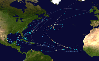
The 2000 Atlantic hurricane season was a fairly active hurricane season, but featured the latest first named storm in a hurricane season since 1992. The hurricane season officially began on June 1, and ended on November 30. It was slightly above average due to a La Niña weather pattern although most of the storms were weak. It was also the only season to have two of the storms affect Ireland. The first cyclone, Tropical Depression One, developed in the southern Gulf of Mexico on June 7 and dissipated after an uneventful duration. However, it would be almost two months before the first named storm, Alberto, formed near Cape Verde; Alberto also dissipated with no effects on land. Several other tropical cyclones—Tropical Depression Two, Tropical Depression Four, Chris, Ernesto, Nadine, and an unnamed subtropical storm—did not impact land. Five additional storms—Tropical Depression Nine, Florence, Isaac, Joyce, and Leslie—minimally affected land areas.
The 2002 Pacific hurricane season was a near–average season which produced fifteen named storms. Eight hurricanes formed, including a record-equaling three Category 5 hurricanes, a record it shares with the 1994 and 2018 seasons. It was also a near-average season in terms of accumulated cyclone energy (ACE), having an ACE of 125. The season officially began on May 15, 2002 in the East Pacific Ocean, and on June 1, 2002 in the Central Pacific; both ended on November 30. These dates conventionally delimit the period of each year when most tropical cyclone formation occurs in these regions of the Pacific. The first system of the 2002 season, Hurricane Alma, formed on May 24, and the last, Tropical Depression Sixteen-E, dissipated on November 16.

The 1996 Pacific hurricane season had below normal tropical cyclone activity, producing 9 tropical storms, of which 5 became hurricanes, with 2 of those intensifying into major hurricanes. With an Accumulated cyclone energy (ACE) index of 53.9, the season ranks among the least intense Pacific hurricane seasons on record. It officially began May 15, 1996, in the eastern north Pacific and on June 1, 1996, in the central north Pacific. It ended on November 30, 1996. These dates conventionally delimit the period of each year when most tropical cyclones form in the northeastern Pacific Ocean. The season slightly exceeded these bounds when tropical storm One-E formed on May 13.

The 1991 Pacific hurricane season was a near-average Pacific hurricane season. The worst storm this year was Tropical Storm Ignacio, which killed 23 people in Mexico and injured 40 others. Elsewhere, Hurricane Fefa caused flooding in Hawaii. Hurricane Kevin was the strongest system of the season and became the then longest-lasting hurricane in the eastern north Pacific basin at the time, and Hurricane Nora was the strongest November storm to that point. The season officially started on May 15, 1991, in the eastern Pacific, and on June 1, 1991, in the central Pacific. It lasted until November 30, 1991, in both basins. These dates conventionally delimit the period of each year when most tropical cyclones form in the northeastern Pacific Ocean.

The 1990 Pacific hurricane season was a very active season which observed 21 named storms within the basin. The season also produced the fourth highest ACE index value on record. The season was officially started on May 15 in the eastern Pacific, and on June 1 in the central Pacific, and lasted until November 30. These dates conventionally delimit the period of each year when most tropical cyclones form in the northeastern Pacific Ocean. However, the formation of tropical cyclones is possible at any time of the year, as illustrated in 1990 by the formation of the season's first named storm, Hurricane Alma, on May 12. At the time, this was the earliest formation of a tropical storm on record in the eastern Pacific

The 1989 Pacific hurricane season was a near normal season. It officially started on May 15, 1989, in the eastern Pacific, and on June 1, 1989, in the central Pacific, and lasted until November 30, 1989. These dates conventionally delimit the period of each year when most tropical cyclones form in the northeastern Pacific Ocean. A total of 18 storms and 9 hurricanes formed, which was near long-term averages. Four hurricanes reached major hurricane status on the Saffir–Simpson scale.

The 2007 Atlantic hurricane season was the first season since 2003 to feature tropical activity both before and after the official bounds of the season. There were an above-average number of named storms during the season – 15, however many storms were weak and short-lived. Despite the predominance of weak systems, this was the first season on record to feature more than one Category 5 landfalling hurricane. This would not happen again until 2017. It produced 17 tropical cyclones, 15 tropical storms, six hurricanes, and two major hurricanes. It officially started on June 1 and ended on November 30, dates which conventionally delimit the period during which most tropical cyclones form in the Atlantic Ocean, although as shown by Subtropical Storm Andrea and Tropical Storm Olga in early May and early December, respectively, the formation of tropical cyclones is possible at any time of the year. The first system, Subtropical Storm Andrea, developed on May 9, while the last storm, Tropical Storm Olga, dissipated on December 13. The most intense hurricane, Dean, was, at the time, the third most intense landfalling Atlantic storm on record. It was the second on record in which an Atlantic hurricane, Felix, and an eastern Pacific hurricane, Henriette, made landfall on the same day. September had a then record-tying eight storms, until it was surpassed in 2020. However, the strengths and durations of most of the storms were low.

The 2007 Pacific hurricane season was a well below-average Pacific hurricane season, featuring only one major hurricane. The season officially started on May 15 in the eastern Pacific and on June 1 in the central Pacific, and ended on November 30; these dates conventionally delimit the period during which most tropical cyclones form in the region. The first tropical cyclone of the season, Alvin, developed on May 27, while the final system of the year, Kiko, dissipated on October 23. Due to unusually strong wind shear, activity fell short of the long-term average, with a total of 11 named storms, 4 hurricanes, and 1 major hurricane. At the time, 2007 featured the second-lowest value of the Accumulated cyclone energy (ACE) index since reliable records began in 1971. Two tropical cyclones – Cosme and Flossie – crossed into the central Pacific basin during the year, activity below the average of 4 to 5 systems.

Hurricane Javier was a powerful tropical cyclone whose remnants brought above-average rainfall totals across the western United States in September 2004. Javier was the tenth named storm, the sixth hurricane and the final major hurricane of the 2004 Pacific hurricane season. Javier was also the strongest hurricane of the 2004 season, with 150 mph (240 km/h) winds and a central pressure of 930 millibars. However, because of high wind shear in the East Pacific, Javier weakened rapidly before making landfall in Baja California as a tropical depression. The remnants of the storm then continued moving northeast through the Southwestern United States. Javier caused no direct fatalities, and the damage in Mexico and the United States was minimal.

The 2008 Pacific hurricane season was a near-average Pacific hurricane season which featured seventeen named storms, though most were rather weak and short-lived. Only seven storms became hurricanes, of which two intensified into major hurricanes. This season was also the first since 1996 to have no cyclones cross into the central Pacific. The season officially began on May 15 in the eastern Pacific and on June 1 in the central Pacific. It ended in both regions on November 30. These dates, adopted by convention, historically describe the period in each year when most tropical cyclone formation occurs in these regions of the Pacific. This season, the first system, Tropical Storm Alma, formed on May 29, and the last, Tropical Storm Polo, dissipated on November 5.

Hurricane Olga was the fifteenth named storm and ninth hurricane of the 2001 Atlantic hurricane season. It was notable as it was the largest tropical cyclone by diameter of gale-force winds on record in the Atlantic at the time. Hurricane Olga formed as a subtropical cyclone on November 24. After acquiring tropical characteristics later that day, Olga meandered westward, and eventually reached hurricane status on November 26. Olga peaked as a 90 mph (140 km/h) Category 1 hurricane before the storm turned southwestward and weakening back into a tropical storm. On November 30 it deteriorated further to a tropical depression, although it re-intensified two days later to tropical storm intensity. Olga then dissipated as a tropical cyclone on December 4 east of the Bahamas. Its damaging effects were limited to ships at sea. The cyclone's remnants produced heavy rainfall across the Bahamas and Florida. It was a relatively rare storm to exist in December, which is outside of the normal Atlantic hurricane season.

The 2011 Pacific hurricane season was a below average season in terms of named storms, although it had an above average number of hurricanes and major hurricanes. During the season, 13 tropical depressions formed along with 11 tropical storms, 10 hurricanes and 6 major hurricanes. The season officially began on May 15 in the East Pacific Ocean, and on June 1 in the Central Pacific; they both ended on November 30. These dates conventionally delimit the period of each year when most tropical cyclones form in the Pacific basin. The season's first cyclone, Hurricane Adrian formed on June 7, and the last, Hurricane Kenneth, dissipated on November 25.

The 2012 Pacific hurricane season was a moderately active Pacific hurricane season that saw an unusually high number of tropical cyclones pass west of the Baja California Peninsula. The season officially began on May 15 in the eastern Pacific Ocean, and on June 1 in the central Pacific (from 140°W to the International Date Line, north of the equator; they both ended on November 30. These dates conventionally delimit the period of each year when most tropical cyclones form in these regions of the Pacific Ocean. However, the formation of tropical cyclones is possible at any time of the year. This season's first system, Tropical Storm Aletta, formed on May 14, and the last, Tropical Storm Rosa, dissipated on November 3.

Tropical Storm Kiko was a strong tropical storm that capsized a boat off the western coast of Mexico, killing at least 15 people. The 15th and final tropical cyclone of the 2007 Pacific hurricane season, Kiko developed out of a tropical wave that formed off the coast of Africa on September 26 and traversed the Atlantic. The wave crossed over Central America and entered the Pacific Ocean on October 8, where it spawned Tropical Depression 15-E on October 15. The depression drifted to the south over the next day before briefly being declared Tropical Storm Kiko. It subsequently weakened into a tropical depression, but later reattained tropical storm intensity. By October 18, Kiko was forecast to make landfall along the western Mexican coastline as a moderate tropical storm. However, the cyclone turned to the west and reached its peak intensity of 70 mph (110 km/h) on October 20. The tropical storm slowly weakened to a remnant low-pressure area by October 24 and completely dissipated on October 27 without making landfall.

The 2006 Pacific hurricane season was the first above-average season since 1997 which produced twenty-five tropical cyclones, with nineteen named storms, though most were rather weak and short-lived. There were eleven hurricanes, of which six became major hurricanes. Following the inactivity of the previous seasons, forecasters predicted that season would be only slightly above active. It was also the first time since 2003 in which one cyclone of at least tropical storm intensity made landfall. The season officially began on May 15 in the East Pacific Ocean, and on June 1 in the Central Pacific; they ended on November 30. These dates conventionally delimit the period of each year when most tropical cyclones form in the Pacific basin. However, the formation of tropical cyclones is possible at any time of the year.

The 2009 Pacific hurricane season was the most active Pacific hurricane season since 1997. The season officially started on May 15 in the East Pacific Ocean, and on June 1 in the Central Pacific; they both ended on November 30. These dates conventionally delimit the period of each year when most tropical cyclones form in the Eastern Pacific tropical cyclone basin; however, tropical cyclone formation is possible at any time of the year. The first system of the season, Tropical Depression One-E, developed on June 18, and the last, Hurricane Neki, dissipated on October 27, keeping activity well within the bounds of the season.

Hurricane Fred was one of the easternmost forming major hurricanes in the North Atlantic basin since satellite observations became available. Forming out of a strong tropical wave on September 7, 2009 near the Cape Verde Islands, Fred gradually organized within an area of moderate wind shear. The following day, decreasing shear allowed the storm to intensify and develop well-organized convective banding features. Later on September 8, Fred attained hurricane intensity and underwent rapid intensification overnight, attaining its peak intensity as a strong Category 3 hurricane with winds of 120 mph (195 km/h) and a barometric pressure of 958 mbar. Shortly after reaching this intensity, the hurricane began to weaken as wind shear increased and dry air hampered convective development.

The 2014 Pacific hurricane season was the fifth-busiest season since reliable records began in 1949, alongside the 2016 season. The season officially started on May 15 in the East Pacific Ocean, and on June 1 in the Central Pacific; they both ended on November 30. These dates conventionally delimit the period of each year when most tropical cyclones form in the Pacific basin.

The 2016 Pacific hurricane season was tied as the fifth-most active Pacific hurricane season on record, alongside the 2014 season. Throughout the course of the year, a total of 22 named storms, 13 hurricanes and six major hurricanes were observed within the basin. Although the season was very active, it was considerably less active than the previous season, with large gaps of inactivity at the beginning and towards the end of the season. It officially started on May 15 in the Eastern Pacific, and on June 1 in the Central Pacific ; they both ended on November 30. These dates conventionally delimit the period of each year when most tropical cyclones form in these regions of the Pacific Ocean. However, tropical development is possible at any time of the year, as demonstrated by the formation of Hurricane Pali on January 7, the earliest Central Pacific tropical cyclone on record. After Pali, however, no tropical cyclones developed in either region until a short-lived depression on June 6. Also, there were no additional named storms until July 2, when Tropical Storm Agatha formed, becoming the latest first-named Eastern Pacific tropical storm since Tropical Storm Ava in 1969.

The 2020 Pacific hurricane season was a near average Pacific hurricane season in terms of named storms, featuring 17, but well below average season for hurricanes and major hurricanes, with only 4 hurricanes and 3 major hurricanes forming. Additionally, no tropical cyclones formed in the Central Pacific basin for the first time since 2017. The season officially began on May 15 in the East Pacific Ocean, and on June 1 in the Central Pacific (from 140°W to the International Date Line, north of the equator; they both ended on November 30. These dates conventionally delimit the period of each year when most tropical cyclones form in the respective regions. However, the formation of tropical cyclones is possible at any time of the year, as illustrated in 2020 by the formation of the season's first system, Tropical Depression One-E, on April 25. This was the earliest formation of a tropical cyclone on record in the eastern Pacific basin proper. The final system of the season was Tropical Storm Polo, which dissipated on November 19.


