Tropical Storm Alma

Last updated
Map key
  Tropical depression (≤38 mph, ≤62 km/h)
  Tropical storm (39–73 mph, 63–118 km/h)
  Category 1 (74–95 mph, 119–153 km/h)
  Category 2 (96–110 mph, 154–177 km/h)
  Category 3 (111–129 mph, 178–208 km/h)
  Category 4 (130–156 mph, 209–251 km/h)
  Category 5 (≥157 mph, ≥252 km/h)
  Unknown
Storm type
Disc Plain black.svg Tropical cyclone
Solid black.svg Subtropical cyclone
ArrowUp.svg Extratropical cyclone, remnant low, tropical disturbance, or monsoon depression

Towards the end of May 2008, computer hurricane models forecast the development of a broad low-pressure area to the southwest of Central America. [1] On May 26, a large trough extended from the southwestern Caribbean Sea across Costa Rica into the eastern Pacific Ocean, forming a broad low-pressure area across the region. [2] A scattered area of strong convection developed, partially in association with the Intertropical Convergence Zone. [1] Located within an area of weak steering currents, the disturbance remained nearly stationary, and on May 27 its shower activity increased in organization. [3] Initially the system consisted of several cyclonic swirls, of which the most pronounced one was located about 340 miles (550 km) west-southwest of San José, Costa Rica. [4] The system gradually became better organized, and with a sufficiently well-developed circulation and convective structure, the National Hurricane Center (NHC) classified the system as Tropical Depression One-E at 0300  UTC on May 29, about 105 miles (169 km) west-northwest of Cabo Blanco, Costa Rica. [5]

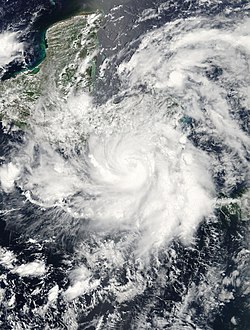
With a mid-level ridge located in the Gulf of Mexico, the depression drifted generally northward through an area of warm water temperatures and low wind shear. Initially its convection was weak and confined to a few rainbands far from the center. As such, intensification was not expected beyond minimal tropical storm status. [5] However, the system quickly developed intense thunderstorms near the center with increased banding in its southern semicircle, and at 1500 UTC on May 29, the NHC upgraded the depression to Tropical Storm Alma, about 55 miles (89 km) southwest of Managua, Nicaragua. This marked one of the rare cases in the Eastern Pacific in which a tropical cyclone formed without the involvement of a tropical wave. [6] The system's intensity was set at 45 mph (72 km/h), and the storm was forecast to intensity only slightly more before moving ashore. [7] However, one hour after it was upgraded to tropical storm status, the NHC re-assessed the intensity as 65 mph (105 km/h), citing updated observations from satellite imagery and QuikSCAT. [8] [6] An eye feature formed, surrounded by a very tight ring of convection, [9] and at around 1900 UTC on May 29, Alma made landfall near León, Nicaragua as a strong tropical storm. [10] The storm quickly weakened after moving ashore, though a small area of thunderstorms persisted as it crossed into the mountainous region of southern Honduras. [11] After passing near Tegucigalpa Alma weakened to tropical depression status, [12] and at 1500 UTC on May 30, the cyclone's low-level lcirculation center dissipated, while the system was situated near the border of Honduras and Guatemala. [13] On May 30, after crossing Central America as a remnant low, Alma's remnants moved into the Gulf of Honduras and merged with another approaching tropical wave from the east, which became Tropical Storm Arthur on the next day. [14] [15]

Preparations and impact

Rainfall from Alma and Arthur Alma Arthur (2008) TRMM rain 27may-4june08.jpg
Rainfall from Alma and Arthur

Coinciding with the first advisory on the depression, the government of Costa Rica issued a tropical storm warning for the entire Pacific coast of the country. [16] About four hours prior to landfall, when Alma was named, a tropical storm warning was in effect for the entire coastlines of Costa Rica, Nicaragua, Honduras, and El Salvador. [17] When it was realized the storm was much stronger than previously thought, a hurricane warning was issued for the coasts of Nicaragua and Honduras, [18] and Alma was forecast to attain hurricane status. [8] Prior to moving ashore, the NHC warned that the storm could produce up to 20 inches (510 mm) of rainfall, resulting in mudslides and flash flooding. [17] The National Emergency Commission of Costa Rica activated emergency shelters prior to the arrival of the storm; 250 people in Parrita evacuated from their homes. [19] In Nicaragua, officials evacuated about 5,000 people, while 3,000 troops were mobilized to assist in the aftermath of the storm. [20]

When Tropical Storm Alma made landfall, it produced moderate to heavy rainfall across Central America. The city of David, Chiriquí in western Panama reported 5.75 inches (146 mm) of precipitation in 48 hours. Additionally, the capital city of San José, Costa Rica reported 3.07 inches (78 mm) of rainfall in a 48‑hour period. [21] In Costa Rica, the precipitation caused river flooding, threatening 17 communities. It also caused widespread mudslides, which closed at least eight roads. The storm downed trees and power lines, leaving about 42,000 people without electricity in the country. [19] Two deaths were reported in the country, and damage in Costa Rica was estimated at ₡20 billion colónes ($35 million 2008  USD). [22]

In León near where it moved ashore in Nicaragua, the passage of Alma left the city without power. Several buildings were destroyed in the city, and some roads were damaged. Much of the departments of León and Chinandega experienced power outages, due to the strong winds. One person died from electrocution, due to a downed high-tension cable, [19] and another person died in a similar manner. [23] Offshore, one person drowned when he rode out the storm in his boat. [24] In Tegucigalpa, TACA Flight 390 skidded off a runway sodden by torrential rain, killing three passengers (plus two more on the ground) and injuring over eighty. [6] One other fatality was reported in Honduras when a young girl was swept away in a raging stream. [6]

Records and retirement

Satellite image of Alma shortly before attaining tropical storm status Alma 29 May 08.jpg
Satellite image of Alma shortly before attaining tropical storm status

Forming at 86.5ºW, [5] Alma developed farther east than any other Pacific tropical cyclone on record. Alma made landfall farther east than any other Pacific tropical cyclone, and it was the only to do so on the Pacific coast of Nicaragua. [11] Alma's remnants contributed to the formation of Tropical Storm Arthur in the Atlantic. [15] [25]

In April 2009, the World Meteorological Organization retired the name Alma from its rotating name lists on account of the heavy rain and strong winds that impacted Central America. It was replaced with Amanda for the 2014 season. [26] [27]

See also

Related Research Articles

<span class="mw-page-title-main">Hurricane Cesar–Douglas</span> Category 4 Atlantic and Pacific hurricane in 1996

Hurricane Cesar–Douglas was one of the few tropical cyclones to survive the crossover from the Atlantic to east Pacific basin, and was the last to receive a new storm name upon doing so. Hurricane Cesar was the third named storm and second hurricane of the 1996 Atlantic hurricane season. The system formed in the southern Caribbean Sea and affected several countries in South America before crossing Nicaragua and entering the Eastern Pacific where it was renamed Hurricane Douglas, the fourth named storm, third hurricane, and first and strongest major hurricane of the 1996 Pacific hurricane season. The storm killed 113 people in Central and South America and left 29 others missing, mainly due to flooding and mudslides.

<span class="mw-page-title-main">Hurricane Adrian (2005)</span> Category 1 Pacific hurricane in 2005

Hurricane Adrian was an early season hurricane which took an unusual southwest to northeast track, bringing it closer to El Salvador than any other hurricane since reliable records began in 1949. The first storm of the 2005 Pacific hurricane season, Adrian developed on May 17, just two days after the official start of the season, several hundred miles south-southeast of Mexico. Tracking in an atypical northwestward direction, the storm gradually intensified. On May 19, the storm reached its peak strength as a minimal hurricane with winds of 80 mph (130 km/h). Not long after reaching this intensity, the storm abruptly weakened. By the morning of May 20, the system had weakened to a minimal tropical storm and turned due west. Later that day, the storm made landfall along the Gulf of Fonseca in Honduras before dissipating several hours later.

<span class="mw-page-title-main">2007 Atlantic hurricane season</span> Hurricane season in the Atlantic Ocean

The 2007 Atlantic hurricane season was the first season since 2003 to feature tropical activity both before and after the official bounds of the season. There were an above-average number of named storms during the season – 15, however many storms were weak and short-lived. Despite the predominance of weak systems, this was the first season on record to feature more than one Category 5 landfalling hurricane. This would not happen again until 2017. It produced 17 tropical cyclones, 15 tropical storms, six hurricanes, and two major hurricanes. It officially started on June 1 and ended on November 30, dates which conventionally delimit the period during which most tropical cyclones form in the Atlantic Ocean, although as shown by Subtropical Storm Andrea and Tropical Storm Olga in early May and early December, respectively, the formation of tropical cyclones is possible at any time of the year. The first system, Subtropical Storm Andrea, developed on May 9, while the last storm, Tropical Storm Olga, dissipated on December 13. The most intense hurricane, Dean, was, at the time, the third most intense landfalling Atlantic storm on record. It was the second on record in which an Atlantic hurricane, Felix, and an eastern Pacific hurricane, Henriette, made landfall on the same day. September had a then record-tying eight storms, until it was surpassed in 2020. However, the strengths and durations of most of the storms were low.

<span class="mw-page-title-main">Hurricane Gert</span> Category 2 Atlantic and Pacific hurricane in 1993

Hurricane Gert was a large tropical cyclone that caused extensive flooding and mudslides throughout Central America and Mexico in September 1993. The seventh named storm and third hurricane of the annual hurricane season, Gert originated as a tropical depression from a tropical wave over the southwestern Caribbean Sea on September 14. The next day, the cyclone briefly attained tropical storm strength before moving ashore in Nicaragua and proceeding through Honduras. It reorganized into a tropical storm over the Gulf of Honduras on September 17, but weakened back to a depression upon crossing the Yucatán Peninsula. Once over the warm waters of the Bay of Campeche, Gert quickly strengthened into a Category 2 hurricane by September 20. The hurricane made a final landfall on the Gulf Coast of Mexico near Tuxpan, Veracruz, with peak winds of 100 mph (160 km/h). The rugged terrain disrupted the cyclone's structure; Gert entered the Pacific Ocean as a depression near the state of Nayarit on September 21, where it briefly redeveloped a few strong thunderstorms before dissipating at sea five days later.

<span class="mw-page-title-main">Hurricane John (2006)</span> Category 4 Pacific hurricane

Hurricane John was a Category 4 hurricane that caused heavy flooding and extensive damage across most of the Pacific coast of Mexico in late August through early September 2006. John was the eleventh named storm, seventh hurricane, and fifth major hurricane of the 2006 Pacific hurricane season. Hurricane John developed on August 28 from a tropical wave to the south of Mexico. Favorable conditions allowed the storm to intensify quickly, and it attained peak winds of 130 mph (210 km/h) on August 30. Eyewall replacement cycles and land interaction with western Mexico weakened the hurricane, and John made landfall on southeastern Baja California Sur with winds of 110 mph (180 km/h) on September 1. It slowly weakened as it moved northwestward through the Baja California peninsula, and dissipated on September 4. Moisture from the remnants of the storm entered the southwest United States.

<span class="mw-page-title-main">2008 Pacific hurricane season</span> Hurricane season in the Pacific Ocean

The 2008 Pacific hurricane season was a near-average Pacific hurricane season which featured seventeen named storms, though most were rather weak and short-lived. Only seven storms became hurricanes, of which two intensified into major hurricanes. This season was also the first since 1996 to have no cyclones cross into the central Pacific. The season officially began on May 15 in the eastern Pacific and on June 1 in the central Pacific. It ended in both regions on November 30. These dates, adopted by convention, historically describe the period in each year when most tropical cyclone formation occurs in these regions of the Pacific. This season, the first system, Tropical Storm Alma, formed on May 29, and the last, Tropical Storm Polo, dissipated on November 5.

<span class="mw-page-title-main">Hurricane Felix</span> Category 5 Atlantic hurricane in 2007

Hurricane Felix was an extremely powerful Category 5 Atlantic hurricane which was the southernmost-landfalling Category 5 storm on record, surpassing Hurricane Edith of 1971. It was the sixth named storm, second hurricane, and second Category 5 hurricane of the 2007 Atlantic hurricane season. Felix formed from a tropical wave on August 31, passing through the southern Windward Islands on September 1 before strengthening to attain hurricane status. On the next day, Felix rapidly strengthened into a major hurricane, and early on September 3 it was upgraded to Category 5 status; at 2100 UTC on the same day, the hurricane was downgraded to Category 4 status, but strengthened into a Category 5 hurricane for the second and final time by the morning of September 4.

<span class="mw-page-title-main">Tropical Storm Arthur (2008)</span> Atlantic tropical storm in 2008

Tropical Storm Arthur was the first Atlantic tropical storm that formed during the month of May since 1981. The first tropical cyclone of the 2008 Atlantic hurricane season, the storm formed on May 30, 2008 from the interaction of two tropical waves and the remnants of the eastern Pacific Tropical Storm Alma, which had crossed into the western Caribbean Sea. The system quickly organized and was named Tropical Storm Arthur on May 31, while crossing the shore of Belize. It dissipated two days later over the Yucatán Peninsula in Mexico. Arthur and its remnants triggered severe flooding which killed a reported nine people and affected 100,000 more in Belize. Damage was light to moderate, estimated at $78 million (2008 USD).

<span class="mw-page-title-main">Tropical Storm Norman (2006)</span> Pacific tropical storm in 2006

Tropical Storm Norman was a weak tropical cyclone that brought heavy rainfall to southwestern Mexico in October 2006. The fifteenth named storm of the 2006 Pacific hurricane season, Norman developed on October 9 from a tropical wave well to the southwest of Mexico. Unfavorable conditions quickly encountered the system, and within two days of forming, Norman dissipated as its remnants turned to the east. Thunderstorms gradually increased again, as it interacted with a disturbance to its east, and on October 15 the cyclone regenerated just off the coast of Mexico. The center became disorganized and quickly dissipated, bringing a large area of moisture which dropped up to 6 inches (150 mm) of rainfall to southwestern Mexico. Rainfall from the storm flooded about 150 houses, of which 20 were destroyed. One person was injured, and initially there were reports of two people missing due to the storm; however, it was not later confirmed.

<span class="mw-page-title-main">Tropical Storm Kiko (2007)</span> Pacific tropical cyclone

Tropical Storm Kiko was a strong tropical storm that capsized a boat off the western coast of Mexico, killing at least 15 people. The 15th and final tropical cyclone of the 2007 Pacific hurricane season, Kiko developed out of a tropical wave that formed off the coast of Africa on September 26 and traversed the Atlantic. The wave crossed over Central America and entered the Pacific Ocean on October 8, where it spawned Tropical Depression 15-E on October 15. The depression drifted to the south over the next day before briefly being declared Tropical Storm Kiko. It subsequently weakened into a tropical depression, but later reattained tropical storm intensity. By October 18, Kiko was forecast to make landfall along the western Mexican coastline as a moderate tropical storm. However, the cyclone turned to the west and reached its peak intensity of 70 mph (110 km/h) on October 20. The tropical storm slowly weakened to a remnant low-pressure area by October 24 and completely dissipated on October 27 without making landfall.

<span class="mw-page-title-main">Tropical Storm Julio (2008)</span> Pacific tropical storm in 2008

Tropical Storm Julio was a tropical storm that made landfall on the southern tip of Baja California Sur in August 2008. The eleventh named storm of the 2008 Pacific hurricane season, it developed from a tropical wave on August 23 off the coast of Mexico. It moved parallel to the coast, reaching peak winds of 50 mph (85 km/h) before moving ashore and weakening. On August 26 it dissipated in the Gulf of California. Julio was the third tropical cyclone to make landfall in the Eastern Pacific tropical cyclone basin during the season, after Tropical Storm Alma, which struck Nicaragua in May, and Tropical Depression Five-E, which moved ashore along southwestern Mexico in July. The storm brought locally heavy rainfall to southern Baja California, killing one person and leaving several towns isolated. Moisture from Julio reached Arizona, producing thunderstorms, including one which damaged ten small planes in Chandler.

<span class="mw-page-title-main">2009 Pacific hurricane season</span> Hurricane season in the Pacific Ocean

The 2009 Pacific hurricane season was the most active Pacific hurricane season since 1997. The season officially started on May 15 in the East Pacific Ocean, and on June 1 in the Central Pacific; they both ended on November 30. These dates conventionally delimit the period of each year when most tropical cyclones form in the Eastern Pacific tropical cyclone basin; however, tropical cyclone formation is possible at any time of the year. The first system of the season, Tropical Depression One-E, developed on June 18, and the last, Hurricane Neki, dissipated on October 27, keeping activity well within the bounds of the season.

<span class="mw-page-title-main">Tropical Depression Five-E (2008)</span> Pacific tropical depression in 2008

Tropical Depression Five-E was a tropical depression which made landfall along the south-western Mexican coastline in July 2008. It was the fifth tropical cyclone of the 2008 Pacific hurricane season. The depression developed out of a weak tropical wave which formed off the coast of Africa on June 23. The wave remained poorly organized throughout its journey through the Atlantic Ocean and Caribbean Sea. The wave entered the Eastern Pacific on July 2 after passing through Central America. The wave developed into an area of low pressure that afternoon.

<span class="mw-page-title-main">Tropical Storm Carlos (2003)</span> Pacific tropical storm in 2003

Tropical Storm Carlos was the first of five tropical cyclones to make landfall during the 2003 Pacific hurricane season. It formed on June 26 from a tropical wave to the south of Mexico. It quickly strengthened as it approached the coast, and early on June 27 Carlos moved ashore in Oaxaca with winds of 65 mph (105 km/h). The storm rapidly deteriorated to a remnant low, which persisted until dissipating on June 29. Carlos brought heavy rainfall to portions of southern Mexico, peaking at 337 mm (13.3 in) in two locations in Guerrero. Throughout its path, the storm damaged about 30,000 houses, with a monetary damage total of 86.7 million pesos. At least nine people were killed throughout the country, seven due to mudslides and two from river flooding; there was also a report of two missing fishermen.

<span class="mw-page-title-main">Tropical Storm Matthew (2010)</span> Atlantic tropical storm in 2010

Tropical Storm Matthew was a weak but deadly and destructive tropical cyclone which made landfall in Central America during the 2010 Atlantic hurricane season. The fifteenth tropical cyclone and thirteenth named storm of the year, Matthew formed on September 23 and lost its tropical characteristics in the morning of September 26. However, its remnants continued to produce life-threatening rain over parts of Central America as it dissipated.

<span class="mw-page-title-main">Meteorological history of Hurricane Mitch</span>

Hurricane Mitch's meteorological history began with its origins over Africa as a tropical wave and lasted until its dissipation as an extratropical cyclone north of the United Kingdom. Tropical Depression Thirteen formed on October 22, 1998, over the southwestern Caribbean Sea from a tropical wave that exited Africa on October 10. It executed a small loop, and while doing so intensified into Tropical Storm Mitch. A weakness in a ridge allowed the storm to track slowly to the north. After becoming disorganized due to wind shear from a nearby upper-level low, Mitch quickly intensified in response to improving conditions which included warm waters and good outflow. It became a hurricane on October 24 and developed an eye. After turning to the west, Mitch rapidly intensified, first into a major hurricane on October 25 and then into a Category 5 on the Saffir-Simpson Hurricane Scale the next day.

<span class="mw-page-title-main">Hurricane Otto</span> Category 3 Atlantic and Pacific hurricane in 2016

Hurricane Otto was a strong late-season tropical cyclone that impacted parts of Central America in November 2016. It was the first Atlantic hurricane since Cesar–Douglas in 1996 to survive the crossover from the Atlantic Ocean to the Pacific Ocean. Forming late on November 20 in the southwestern Caribbean Sea, Otto was the fifteenth and final named storm, seventh hurricane and fourth major hurricane of the 2016 Atlantic hurricane season. It quickly intensified into a strong tropical storm the next day, and on November 23–24, rapidly strengthened into a Category 3 hurricane, the first in the month of November since Hurricane Paloma in 2008, and the latest date an Atlantic hurricane attained such intensity on record. Otto made landfall in Nicaragua at peak intensity on November 24, thus becoming the latest hurricane to make landfall in the Atlantic basin since 1851 when records began. Traveling along the Nicaragua–Costa Rica border, the system rapidly weakened to a tropical storm before emerging over the eastern Pacific Ocean, becoming the final storm of the 2016 Pacific hurricane season as well. Hostile environmental conditions inhibited reorganization, and Otto subsequently degenerated into an elongated trough on November 26.

<span class="mw-page-title-main">Hurricane Nate</span> Category 1 Atlantic hurricane in 2017

Hurricane Nate was an Atlantic hurricane which was the costliest natural disaster in Costa Rican history. An unusually fast-moving tropical cyclone, it caused severe flooding in Central America, leading to widespread destruction and casualties, during early October 2017, before making landfall on the US Gulf Coast. The fourteenth named storm and ninth hurricane of the extremely active 2017 Atlantic hurricane season, Nate originated from a broad area of low pressure over the southwestern Caribbean on October 3. The disturbance moved northwest, organizing into a tropical depression the next day and attaining tropical storm intensity early on October 5. The storm made landfall in Nicaragua that same day and continued into Honduras with little change in strength. Nate began steady intensification over the warm waters of the northwestern Caribbean Sea shortly thereafter. It attained hurricane strength while moving through the Yucatán Channel early on October 7, attaining peak winds of 90 mph (150 km/h) in the central Gulf of Mexico later that day. Early on the next day, Nate made landfall near the mouth of the Mississippi River in Louisiana. After crossing the marshland of the Mississippi Delta, it made its second U.S. landfall near Biloxi, Mississippi early on October 8, causing a storm surge to flood the ground floors of coastal casinos and buildings, as well as causing rip currents, hurricane-force winds, and beach erosion.

<span class="mw-page-title-main">Tropical Storm Selma (2017)</span> Pacific tropical storm in 2017

Tropical Storm Selma was the first tropical storm on record to make landfall in El Salvador, and only the second Pacific tropical cyclone to attain tropical storm strength east of 90°W, the other being Alma of 2008. The twentieth tropical cyclone and eighteenth named storm of the 2017 Pacific hurricane season, Selma formed from a Central American gyre on October 27. The storm tracked northeastward and reached its peak intensity as a minimal tropical storm before making landfall east of San Salvador, El Salvador early on October 28. Selma rapidly weakened after making landfall, and its remnant circulation dissipated overland at 18:00 UTC on the same day.

References

  1. 1 2 Nelson (2008). "May 26 Tropical Weather Discussion for the Eastern Pacific Ocean". National Hurricane Center. Retrieved 2008-05-28.[ permanent dead link ]
  2. Berg (2008). "May 26 Tropical Weather Discussion for the Atlantic Ocean". National Hurricane Center. Retrieved 2008-05-28.[ permanent dead link ]
  3. Franklin/Landsea (2008). "May 27 Tropical Weather Outlook". National Hurricane Center. Retrieved 2008-05-28.[ permanent dead link ]
  4. Nelson (2008). "May 27 Tropical Weather Discussion for the Eastern Pacific Ocean". National Hurricane Center. Retrieved 2008-05-28.[ permanent dead link ]
  5. 1 2 3 Franklin/Rhome (2008). "Tropical Depression One-E Discussion One". National Hurricane Center. Retrieved 2008-05-28.
  6. 1 2 3 4 Brown (2008). "Tropical Cyclone Report: Tropical Storm Alma" (PDF). National Hurricane Center . Retrieved 2008-07-22.
  7. Avila/Roberts (2008). "Tropical Storm Alma Discussion Three". National Hurricane Center. Retrieved 2008-05-29.
  8. 1 2 Avila (2008). "Tropical Storm Alma Special Discussion Four". National Hurricane Center. Retrieved 2008-05-29.
  9. Avila/Roberts (2008). "Tropical Storm Alma Discussion Five". National Hurricane Center. Retrieved 2008-05-29.
  10. Avila/Roberts (2008). "Tropical Storm Alma Public Advisory Five". National Hurricane Center. Retrieved 2008-05-29.
  11. 1 2 Knabb/Blake (2008). "Tropical Storm Alma Discussion Six". National Hurricane Center. Retrieved 2008-05-29.
  12. Beven (2008). "Tropical Depression Alma Discussion Seven". National Hurricane Center. Retrieved 2008-05-30.
  13. Avila (2008). "Tropical Depression Alma Discussion Eight". National Hurricane Center. Retrieved 2008-05-30.
  14. Eric Blake (2008). "Tropical Storm Arthur: Tropical Cyclone Report" (PDF). National Hurricane Center. Retrieved 2008-07-29.
  15. 1 2 Avila/Rhome (2008). "Tropical Storm Arthur Special Discussion One". National Hurricane Center. Retrieved 2008-05-31.
  16. Franklin/Rhome (2008). "Tropical Depression One-E Public Advisory One". National Hurricane Center. Retrieved 2008-05-28.
  17. 1 2 Avila/Roberts (2008). "Tropical Storm Alma Public Advisory Three". National Hurricane Center. Retrieved 2008-05-29.
  18. Avila (2008). "Tropical Storm Alma Special Public Advisory Four". National Hurricane Center. Retrieved 2008-05-29.
  19. 1 2 3 El País (2008-05-30). "Alma deja un muerto y cientos de evacuados a su paso por Centroamérica" (in Spanish). Archived from the original on 2011-05-20. Retrieved 2011-04-30.
  20. Filadelfo Aleman (2008-05-29). "Tormenta tropical Alma golpea Centroamérica" (in Spanish). El Nuevo Herald. Retrieved 2008-05-29.[ dead link ]
  21. Berg (2008). "May 29 Atlantic Tropical Weather Discussion". National Hurricane Center. Retrieved 2008-05-29.[ permanent dead link ]
  22. Werner Stolz & Gabriela Chinchilla. "Tormenta Tropical Alma y sus efectos en Costa Rica (27-30 de mayo de 2008)" (PDF) (in Spanish). Instituto Meteorólogico Nacional. Archived from the original (PDF) on 2011-07-16. Retrieved 2009-03-28.
  23. Rosenberg, Mica (2008-05-31). "Tropical Storm Alma dies out over Central America". Reuters UK. Archived from the original on 2009-06-01. Retrieved 2008-05-31.
  24. Agence France-Presse (2008-05-29). "Un muerto y daños por paso de tormenta "Alma"". Archived from the original on 2011-09-29. Retrieved 2008-05-30.
  25. Stephen Caparotta; D. Walston; Steven Yound & Gary Padgett. "Subject: E15) What tropical storms and hurricanes have moved from the Atlantic to the Northeast Pacific or vice versa?". Frequently Asked Questions. Hurricane Research Division, Atlantic Oceanographic and Meteorological Laboratory . Retrieved 2008-05-31.
  26. RA IV Hurricane Committee Thirty-First Session Final Report (PDF) (Report). World Meteorological Organization. 2009. p. 11. Archived from the original (PDF) on March 3, 2016. Retrieved September 30, 2021.
  27. "Storm committee drops Gustav, Ike, Paloma and Alma". Sun Journal . Lewiston, Maine. May 2, 2009. Retrieved January 11, 2024.
Tropical Storm Alma
Alma 2008-05-29 1635Z.jpg
Tropical Storm Alma approaching Nicaragua on May 29