Typhoon Paka,known as Rubing by PAGASA,was an extremely powerful and long-lived storm that devastated Guam and the Marshall Islands in December 1997. One of the strongest Pacific typhoons ever recorded in December,Paka was the last tropical cyclone of the 1997 Pacific hurricane season and 1997 Pacific typhoon season and the last of a record eleven super typhoons that formed in 1997.[1] Paka,which is the Hawaiian name for Pat,[2] developed on 28 November from a trough well to the southwest of Hawaii. The storm tracked generally westward for much of its duration,and on 7 December it crossed into the western Pacific Ocean. Much of its track was characterized by fluctuations in intensity,and on 10 December the cyclone attained typhoon status as it crossed the Marshall Islands. On 16 December,Paka struck Guam and Rota with winds of 230km/h (140mph),and it strengthened further to reach peak winds on 18 December over open waters as the final super typhoon of the year. Subsequently,it underwent a steady weakening trend,and on 23 December Paka dissipated.
Typhoon Paka first impacted the Marshall Islands,where it dropped heavy rainfall and left US$80million in damages. Later,it passed just north of Guam,where strong winds destroyed about 1,500buildings and damaged 10,000more;5,000people were left homeless,and the island experienced a complete power outage following the typhoon. Damage on the island totaled US$500million,which warranted the retirement of its name. Paka also caused minor damage in the Northern Mariana Islands,and overall,the typhoon did not cause any reported fatalities.
Meteorological history
Map plotting the storm's track and intensity,according to the Saffir–Simpson scale
As the weather synoptics of the northern Pacific Ocean transitioned into a late-fall to early winter-type pattern, convection from the monsoon trough extended to the east of the International Date Line. During late November, a westerly disturbance developed into twin troughs on opposite sides of the equator; the one in the Southern Hemisphere eventually developed into Tropical Cyclone Pam, while the one in the Northern Hemisphere formed into an area of convection about 2,000km (1,200mi) southwest of Hawaii. The disturbance gradually organized as it drifted north-northeastward, and on 28 November it developed into Tropical Depression Five-C about 465km (289mi) west-northwest of Palmyra Atoll. Operationally, the Central Pacific Hurricane Center (CPHC) did not begin issuing warnings on the system until 2 December.[2][3][4][5]
The tropical depression continued drifting north-northeastward, and failed to strengthen significantly. It turned to the west on 1 December, due to the presence of a strong anticyclone to its north with a ridge extending westward past the International Date Line. On 2 December, based on satellite estimates, the CPHC upgraded the depression to Tropical Storm Paka while located about 1,000km (620mi) south-southeast of Johnston Atoll. Due to the presence of high clouds across the area, forecasters had difficulty at times in locating the low-level circulation. After becoming a tropical storm, Paka remained nearly stationary for about two days before resuming a slow motion to the west-southwest. It steadily intensified due to warm water temperatures, and on 3 December the storm attained winds of 105km/h (65mph). The next day, however, it encountered dry air and began weakening; by 6 December, the winds had decreased to minimal tropical storm status for about 12hours. Subsequently, Paka began to re-intensify, and on 7 December the storm crossed the International Date Line into the western North Pacific Ocean with winds of 80km/h (50mph).[2][5]
Upon entering the western North Pacific Ocean, tropical cyclone warning duties transferred from the CPHC to the Japan Meteorological Agency (JMA), and the JMA first assessed Paka as a 65km/h (40mph) storm.[6] The Joint Typhoon Warning Center (JTWC) unofficially assumed warning duties for interests in the United States Department of Defense. Paka continued to intensify after crossing the date line, and from late on 7 December through early the following day it remained a strong tropical storm. However, upper-level wind shear increased, and it again weakened. At 1200UTC on 9 December, the JTWC assessed Paka as an 85km/h (53mph) tropical storm and forecast it to continue weakening. By 10 December, the shear had begun to decrease as the storm moved through the Marshall Islands, and that night the JTWC upgraded Paka to typhoon status.[4] Paka officially attained typhoon status when JMA classified it with winds of 120km/h (75mph) at 0000UTC on 11 December.[6]
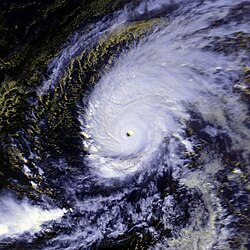
Super Typhoon Paka on 15 December
After attaining typhoon status, Paka strengthened fairly quickly, and by 12 December it reached sustained winds of 150km/h (93mph) for a ten-minute (10 min) duration,[6] or 215km/h (134mph) over a one-minute (1 min) duration. Subsequently, it briefly weakened as its forward motion increased. However, Paka again re-intensified, and at 1200UTC on 14 December it attained the unofficial ranking of Category5 super typhoon status while over the open Pacific Ocean with estimated 1-minute sustained winds of 260km/h (160mph).[4] At the same time, the JMA classified it with 10 min sustained winds of 175km/h (109mph).[6] After reaching its initial peak intensity, Paka underwent an eyewall replacement cycle and began weakening as it approached the southern Mariana Islands; the NEXRAD Doppler weather radar from Guam revealed the presence of a primary eyewall of 74km (46mi) in diameter, with a fragmented inner wall cloud of 19km (12mi) in diameter.[4] Additionally, satellite imagery indicated an eyewall mesovortex within the eye of the typhoon.[7] It slowed and began to re-intensify as it continued westward, and at 0530UTC on 16 December the northern portion of the outer eyewall of Paka passed over the island of Rota; 20minutes later, the southern portion of the inner wall cloud moved across northern Guam.[4] As it tracked through the Rota Channel, the center of Paka passed about 8km (5.0mi) north of the northern tip of Guam, its closest approach to the island.[8]
Typhoon Paka continued to steadily intensify after passing the Marianas Islands, and late on 17 December it reached its peak intensity of 185km/h (115mph)10 min sustained) while located 440km (270mi) west-northwest of Guam.[6] Early on 18 December, the JTWC assessed it as attaining peak winds of 295km/h (183mph)1 min winds).[4] On 19 December, it entered the area of responsibility of the Philippine Atmospheric, Geophysical and Astronomical Services Administration, or PAGASA, and was named Rubing.[9] Shortly thereafter, Paka moved through an area of progressively increasing wind shear, which resulted in a steady weakening trend.[7] By 21 December, winds decreased to tropical storm status. The next day, it degenerated into a tropical depression before it dissipated on 23 December.[6]
Preparations and impact
Marshall Islands
Prior to the typhoon passing through the Marshall Islands, several hundred residents on the island of Ebeye fled to safer structures. The threat of Paka prevented Continental Micronesia from flying in or out of the area.[10]
Paka entered the Marshall Islands between Mili and Majuro as a tropical storm on 10 December, and after strengthening into a typhoon, it left the archipelago on 14 December.[8] The cyclone affected several islands in the nation, and the Majuro and Kwajalein atolls reported wind gusts in excess of 75km/h (47mph).[4] On Jaluit Atoll, the typhoon dropped 217mm (8.5in) of precipitation in six hours, with a total of about 300mm (12in) recorded in 30hours.[11] Strong waves inundated low-lying islands, which flooded crops with salt water.[10] The combination of the wind and flooding caused severe damage to banana, papaya, and lime trees across the territory.[8] Typhoon Paka damaged 70% of the houses on Ailinglaplap Atoll, and most of the coconut trees on the atoll were left toppled or damaged. Strong winds left large portions of Ebeye island without electricity or telephone.[10] The typhoon caused no reported deaths or injuries in the region, and damage was estimated at US$80million.[8]
Passing a short distance north of the island, Typhoon Paka produced strong winds across northern Guam, though reliable wind reports are incomplete due to the long duration and intensity of the winds. The highest reading believed to be reliable was at Apra Harbor. There, a station recorded a wind gust of 277km/h (172mph) before the sensor failed as winds shifted to the southwest; since the winds from the southwest were stronger and of greater duration, officials believe gusts there reached 297km/h (185mph).[4] Additionally, Andersen Air Force Base recorded a peak wind gust of 381km/h (237mph),[12] which at the time was considered the highest wind speed on record, surpassing the 1934 world record of 372km/h (231mph) on Mount Washington in New Hampshire.[13] However, a subsequent wind survey of the area discarded the reading at the base, as it was considered unreliable.[12] As microbarographs are less exposed than wind sensors, pressure readings on the island are considered accurate; the lowest reading on the island was 948hPa (27.99inHg) at Andersen Air Force Base.[4] In two days, the typhoon dropped about 533mm (21.0in) of precipitation on the northern portion of the island, or about 89% of the monthly rainfall total.[14] Waves along northern Guam reached about 11m (36ft) in height.[15]
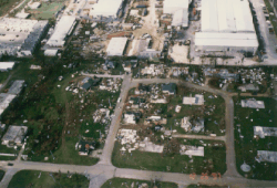
The strong winds from Paka left around 1,500buildings destroyed on the island,[15] of which 1,160 were single-family homes.[8] A further 10,000buildings sustained damage to some degree,[15] with 60% of the homes on the island reporting major damage.[8] In all, about 5,000people were left homeless due to the typhoon. Additionally, an estimated 30–40% of the public buildings received major damage.[8] Buildings on the island made of reinforced concrete fared well, as opposed to light metal-frame structures, which more often than not were destroyed. Large tourist hotels near Hagåtña, on which Guam is dependent, received generally minor damage, such as broken windows and damaged power generators.[15]
A complete island-wide power outage followed the typhoon; damage to the main electrical transmission and distribution system was estimated at USD16million. Following the passage of the typhoon, 25% of the homes on Guam were left without water.[8] Telephone service remained working after the storm, due to most lines being underground. Strong waves washed away a few coastal roads in the northern portion of the island, leaving them temporarily closed. The waves surpassed the seawall at Apra Harbor, damaging the road and infrastructure of the seaport; many boats were washed ashore after breaking from their moorings. Strong winds damaged a radar system and lights along the runway of the Antonio B. Won Pat International Airport, though most airport facilities received light damage. Andersen Air Force Base also sustained heavy damage, with hundreds of downed trees and many facilities left damaged.[15] Across Guam, damage was estimated at USD500million.[8] About 100people were injured,[16] but the typhoon caused no deaths on the island.[8]
A typhoon watch was issued for Rota, Tinian, and Saipan on 14 December, which was upgraded to a typhoon warning the next day.[8] Because Paka was intensifying while passing to the south of Rota, the first wind, or northeast through east winds, was less severe than the second wind from the southeast.[4] Sustained winds on the island reached 145km/h (90mph), with gusts reaching 185km/h (115mph).[8] Many trees in the mountainous portion of the island were left defoliated, which limited nesting and foraging sites for the endangered bridled white-eye bird.[17] While passing to the south of the island, Paka dropped 250–300mm (9.8–11.8in) of rain.[14] Damage on the island totaled $4.4million (1997USD, $6.4million 2015USD).[8] The typhoon also produced above-normal precipitation on Saipan.[14]
Aftermath
Following the passage of the typhoon in the Ailinglaplap Atoll in the Marshall Islands, residents experienced severe food shortages due to damaged crops and little rainfall. Experts estimated the entire redevelopment of its fauna would require more than a decade. As a result of the crop shortage, large-scale evacuations of the islands' residents were considered. Officials in the nation requested assistance from the Federal Emergency Management Agency of the United States,[18] and on 20 March 1998, the area was declared a disaster area; the declaration allowed for the usage of emergency funds.[19]
On 17 December 1997, PresidentBill Clinton declared Guam a federal disaster area, making it eligible for federal assistance.[20] One week later, a disaster declaration was ordered for the Northern Mariana Islands.[21] Ultimately, FEMA received 14,770Individual Assistance Applications from residents on Guam. In turn, FEMA provided the residents with over $27million in assistance (1997USD, $39million 2015USD).[22] The entire island of Guam was left without power after Paka. Water and sewage systems on Guam were directly affected minimally by the typhoon. With the usage of power generators, most areas of the island had water pumping capabilities within a few days after the typhoon. The Antonio B. Won Pat International Airport was partially reopened to daytime flights a day after the typhoon, and by a week after the passage of Paka the airport was fully re-opened.[15]
Retirement
Due to the typhoon's impacts on Guam, the World Meteorological Organization later retired the name Paka from future use in the central North Pacific. The name Pama was chosen as its replacement.[23][24]
This page is based on this Wikipedia article Text is available under the CC BY-SA 4.0 license; additional terms may apply. Images, videos and audio are available under their respective licenses.


