Tropical Storm Linda (1997)

Last updated

Map key
  Tropical depression (≤38 mph, ≤62 km/h)
  Tropical storm (39–73 mph, 63–118 km/h)
  Category 1 (74–95 mph, 119–153 km/h)
  Category 2 (96–110 mph, 154–177 km/h)
  Category 3 (111–129 mph, 178–208 km/h)
  Category 4 (130–156 mph, 209–251 km/h)
  Category 5 (≥157 mph, ≥252 km/h)
  Unknown
Storm type
Disc Plain black.svg Tropical cyclone
Solid black.svg Subtropical cyclone
ArrowUp.svg Extratropical cyclone, remnant low, tropical disturbance, or monsoon depression

The origins of Typhoon Linda were from an area of convection that were first noted east of the Philippines on October 26. A subtropical ridge persisted to the north, which caused the disturbance to move generally westward. On October 29, the system crossed the Philippines and entered the South China Sea. It subsequently began to organize, and late on October 31, the Joint Typhoon Warning Center (JTWC) initiated advisories on Tropical Depression 30W. At that time, the system was located off the northwest coast of Borneo. [1] The PAGASA organization named it "Openg". [2]

Shortly after developing, the depression intensified into a tropical storm, and was named "Linda" by the JTWC. It continued to intensify, reaching winds of 65 mph (105 km/h) as it approached southern Vietnam. At 0900 UTC on November 2, Linda made landfall in the Vietnamese province of Cà Mau. It maintained its strength over land, and the storm quickly reached typhoon status after entering the Gulf of Thailand; a typhoon is a tropical cyclone with winds of at least 75 mph (121 km/h), although Linda did not intensify beyond minimal typhoon status. Turning northwestward, Linda deteriorated to tropical storm strength, and struck Thailand late on November 3 with winds of 65 mph (105 km/h). [1]

Linda weakened further over the mountainous terrain of the Malay Peninsula, and the storm emerged into the Andaman Sea with winds of 50 mph (80 km/h). This made Linda the first tropical cyclone since Tropical Storm Forrest in 1992 to cross from the western Pacific Ocean into the Indian Ocean. [1] Additionally, upon reaching the Indian Ocean, the India Meteorological Department (IMD) classified the storm as Cyclonic Storm BOB 08, with winds of 40 mph (64 km/h). [3] With warm waters, Tropical Storm Linda gradually re-intensified as it slowed down, due to a weakness in the subtropical ridge. On November 6, it again attained typhoon status while located off the southwest coast of Burma (Myanmar). [1] Initially, it was expected to cross the Bay of Bengal and make landfall near the India/Bangladesh border. [4] The cyclone only maintained peak strength for 18 hours, due to an increase in wind shear from a mid-latitude trough. Linda's motion became nearly stationary, and it gradually weakened for several days. On November 9, Linda dissipated about 375 miles (604 km) southwest of Yangon, Burma. [1] That day, the IMD also terminated advisories. [3]

Impact and aftermath

Severe Tropical Storm Linda (Openg)
Linda Nov 3 1997 0717Z.png
Linda at peak intensity nearing the Malay Peninsula on November 3
Deaths by country
Vietnam 3,111
Thailand 164
Total3,275
Satellite image of broader Indochina, including Vietnam on the right and Thailand to the left Thailand BMNG.png
Satellite image of broader Indochina, including Vietnam on the right and Thailand to the left

Prior to the arrival of the storm, officials in Vietnam issued warnings to the residents, although its approach was faster than expected, and the region rarely experiences tropical cyclones. Tropical Storm Linda dropped heavy rainfall across southern Vietnam, peaking at 9.17 inches (23.3 cm) in Cần Thơ. [5] The storm caused heavy damage in the country, particularly in the southernmost province of Cà Mau where it struck, [1] but also in Bạc Liêu, Sóc Trăng, and Kiên Giang. [6] The most severely affected regions were poor fishing communities. [7] Overall, the storm damaged 139,445 houses and wrecked 76,609 more, [8] which left 383,045 people homeless. [9] Thousands of schools were damaged, and 130,815 dykes were breached. [5] Additionally, the storm destroyed at least 3,122 boats. [8] The rainfall also flooded 1,750 square miles (4,500 km2) of rice paddy crop, about half of which in Cà Mau. [10] A preliminary damage total was estimated at 7.18 trillion dongs (US$385 million). [11]

Typhoon Linda caused considerable deaths in Vietnam. Many fishermen and sailors were caught at sea in the path of the storm, [1] unable to escape its path. [5] Within three days, the death toll in Vietnam was set at over 150, with thousands missing, [4] many of them fishermen. [10] By the fourth day after the storm, the toll reached 390, [6] and on November 14, eight days after the storm, the death toll reached 464. [8] Ultimately, the death toll was set at 3,111. [11] Eight days after Linda's passage, a United Nations Department of Humanitarian Affairs (DHA) report indicated 857 people were injured by the storm. [8] The government quickly established search and rescue teams, particularly for missing fishermen, and a total of 3,513 people were rescued after the storm. [5] In the weeks after the storm, hundreds of dead bodies washed ashore in Vietnam and Thailand. [12]

The Vietnamese government identified basic supplies that it needed in response to the storm; those included various foods, clothing, medicine, shelter supplies, and sanitation equipment. [6] The country made a formal request for international assistance, noting that the storm was the worst in 100 years, and officials had limited resources due to the unexpected destruction. [5] Prior to the request, the government of Switzerland sent about 500,000 Swiss francs (US$360,000) for immediate relief assistance. [10] Subsequently, ten other countries sent cash or relief supplies worth $2.6 million, including medical shelters from the United States, clothing from the United Kingdom, tents from Russia, and transport goods from Japan. [5] Red Cross workers had to travel by riverboat to bring aid to the most affected communities, [7] due to the poor state of the roads. [12] After two months, the Red Cross distributed 65,401 roofing sheets, 390 metric tons of rice, 11,990 mosquito nets, 6,871 blankets, 3,664 medical kits, and abundant clothing supplies to about 150,000 affected people; the supplies were purchased in Ho Chi Minh City. Eventually, the food supply and health status of the storm victims proved not as bad as originally feared. After the assistance was distributed, the Red Cross shifted focus toward reconstruction. Reconstruction was slow, partly due to a slowdown in economic activity from the Vietnamese New Year. Additionally, the two primary factories responsible for making iron and construction frames were only intermittently open, due to machines failing. [13] [14]

Elsewhere, moderate damage was also reported in Thailand, [1] where at least 12 casualties were reported on land, [12] and at least 152 fishermen were killed at sea. [15] Flash flooding occurred in six districts, which damaged about 88 square miles (230 km2) of croplands and destroyed 12 houses. Land transportation was affected, with 184 roads and 14 bridges damaged. The government of Thailand sent 20 medical teams to the most affected areas. [16] Following the storm, about 10,600 people became sick from flood related diseases. [17] Heavy rains fell in Tanintharyi Division in southeastern Burma (Myanmar), although because the winds were not strong, there was little damage. The typhoon increased smog and haze in Indonesia and Malaysia, which had been occurring for weeks. In Indonesia, the typhoon also removed atmospheric moisture, which lowered the chance for rain in areas affected by wildfires. [4] Cambodia was also affected by the outskirts of the storm. [10]

See also

Related Research Articles

<span class="mw-page-title-main">Cyclone Mala</span> North Indian Ocean extremely severe cyclonic storm in 2006

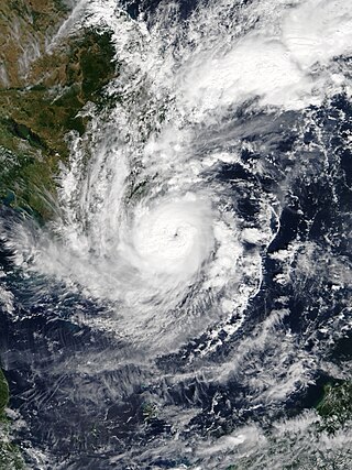
Extremely Severe Cyclonic Storm Mala was the strongest tropical cyclone of the 2006 North Indian Ocean cyclone season. In mid-April 2006, an area of disturbed weather formed over the southern Bay of Bengal and nearby Andaman Sea. Over a period of several days, the system became increasingly organized and was classified as a depression on April 24. Situated within a region of weak steering currents, the storm slowly intensified as it drifted in a general northward direction. It attained gale-force winds and was named Mala the next day. Conditions for strengthening improved markedly on April 27 and Mala subsequently underwent rapid intensification which culminated in the cyclone attaining its peak. Early on April 28, the cyclone had estimated winds of 185 km/h (115 mph). The Joint Typhoon Warning Center considered Mala to have been slightly stronger, classifying it as a Category 4-equivalent cyclone. Steady weakening ensued thereafter and the storm made landfall in Myanmar's Rakhine State on April 29. Rapid dissipation took place once onshore and Mala was last noted early the next morning.

<span class="mw-page-title-main">Typhoon Chanchu</span> Pacific typhoon in 2006

Typhoon Chanchu, known in the Philippines as Typhoon Caloy, was the most intense typhoon in the South China Sea in the month of May according to the Hong Kong Observatory (HKO). The first named storm of the 2006 Pacific typhoon season, Chanchu formed on May 8 in the vicinity of the Federated States of Micronesia and progressed westward. It gradually intensified into a tropical storm and later severe tropical storm before moving through the Philippines. On May 13, Chanchu entered the South China Sea and became a typhoon, according to the Japan Meteorological Agency (JMA). Warm waters and favorable outflow allowed the storm to quickly intensify to peak maximum sustained winds of 175 km/h (109 mph) on May 15. Around that time, the typhoon turned sharply to the north toward southeastern China. Chanchu weakened as it curved to the northeast, making landfall near Shantou, Guangdong on May 17 as a severe tropical storm. The government of China considered Chanchu the earliest typhoon to make landfall in the province. On the next day, the storm emerged into the East China Sea, becoming extratropical on May 19 before dissipating west of Kyushu.

<span class="mw-page-title-main">Typhoon Xangsane</span> Pacific typhoon in 2006

Typhoon Xangsane, known in the Philippines as Typhoon Milenyo, was a typhoon that affected the Philippines, Vietnam, and Thailand during the 2006 Pacific typhoon season. The name Xangsane was submitted by Laos and means elephant.

<span class="mw-page-title-main">Typhoon Muifa (2004)</span> Pacific typhoon in 2004

Typhoon Muifa, known in the Philippines as Typhoon Unding, was a strong typhoon during the 2004 Pacific typhoon season. The name Muifa is taken from the ume blossom.

<span class="mw-page-title-main">Typhoon Durian</span> Pacific typhoon in 2006

Typhoon Durian, known in the Philippines as Typhoon Reming, was a deadly tropical cyclone that wreaked havoc in the Philippines and later crossed the Malay Peninsula in late November 2006, causing massive loss of life when mudflows from the Mayon Volcano buried many villages.

<span class="mw-page-title-main">Cyclone Ivy</span> Category 4 South Pacific cyclone in 2004

Severe Tropical Cyclone Ivy was a tropical cyclone that affected about 25% of the population of Vanuatu in February 2004. It was first classified as a tropical disturbance on February 21 between Vanuatu and Fiji. The system tracked northwestward, gradually organizing and intensifying. After attaining tropical storm status on February 23, Ivy strengthened more quickly as it turned southwestward toward Vanuatu. It attained peak winds of 165 km/h (103 mph) while moving over Vanuatu, making it an intense Category 4 cyclone on the Australian Region Tropical Cyclone Intensity Scale. By the time it passed through Vanuatu, Ivy had turned southeastward, and it gradually weakened while accelerating. After becoming extratropical on February 28, it passed just east of New Zealand and eventually dissipated on March 2.

<span class="mw-page-title-main">Cyclone Trina</span> Category 1 South Pacific cyclone in 2001

Tropical Cyclone Trina was a weak but destructive tropical cyclone in late 2001 which caused some of the worst flooding in the South Pacific island of Mangaia, Cook Islands, in nearly 50 years. Forming out of an upper-level low pressure system on November 29 near the island of Rarotonga, or roughly 1,470 mi (2,365 km) southeast of Fiji, Trina remained practically stationary as it meandered in the same general area for over a week. Due to unfavorable conditions for tropical cyclogenesis, the storm struggled to develop significant convection, preventing it from intensifying beyond 65 km/h (40 mph). After finally succumbing to wind shear on December 2, the system weakened to a tropical depression near Mangaia and dissipated several days later.

<span class="mw-page-title-main">Tropical cyclones in Myanmar</span>

At least 29 tropical cyclones have affected Myanmar, a country adjacent to the Bay of Bengal in mainland Southeast Asia. Myanmar has witnessed some of the deadliest storms in the Bay of Bengal, including Cyclone Nargis in May 2008, which struck the low-lying Irrawaddy Delta near Yangon. Its winds and storm surge killed an estimated 140,000 people and left nearly $10 billion in damage. The country's worst natural disaster in the 20th century was a cyclone in 1968, which killed more than 1,000 people when it hit Rakhine State in northwestern Myanmar. One of the most powerful storms to ever hit the country was Cyclone Mocha, which it moved ashore northwestern Myanmar in May 2023, killing at least 413 people.

<span class="mw-page-title-main">Typhoon Cecil</span> Pacific typhoon in 1985


Typhoon Cecil, known in the Philippines as Tropical Storm Rubing, was one of two typhoons to strike Vietnam within a week in 1985. Cecil originated from an area of convection that tracked west-northwest and passed south of Palau late on October 9. The disturbance became increasingly defined as it moved through the southern Philippines. On October 12, a tropical depression developed, and the next day, the depression was upgraded into a tropical storm. Cecil turned northwest over the open waters of the South China Sea as it steadily strengthened, and was classified as a typhoon on October 14. After unexpectedly slowing down, Cecil continued to intensify and at noon of October 14, reached its peak intensity of 145 km/h (90 mph). Land interaction with Vietnam triggered a weakening trend. After turning west, Cecil moved onshore just north of Huế at 22:00 UTC on October 15. After tracking into Laos, the typhoon dissipated 39 hours later.

<span class="mw-page-title-main">Tropical Storm Cecil</span> Pacific severe tropical storm in 1989

Severe Tropical Storm Cecil in May of 1989 caused devastating floods in central Vietnam, killing 751 people. The storm developed as a tropical depression over the South China Sea on May 22. Tracking north-northwestward, the system steadily intensified, attaining peak winds of 110 km/h (68 mph). The Joint Typhoon Warning Center (JTWC) assessed Cecil to have been slightly stronger with one-minute sustained winds of 140 km/h (87 mph). The storm made landfall near Hoi An, Vietnam early on May 25 and quickly weakened. The system later dissipated over Laos on May 26.

<span class="mw-page-title-main">Typhoon Cimaron (2006)</span> Pacific typhoon in 2006

Typhoon Cimaron, known in the Philippines as Super Typhoon Paeng, was the most intense tropical cyclone to strike the Philippine island of Luzon since Typhoon Zeb in 1998. Originating from a tropical depression on October 25, Cimaron developed within an environment strongly favoring tropical cyclogenesis east of the Philippines. On October 28, the system underwent rapid intensification, culminating in attaining its peak strength with winds of 185 km/h (115 mph). Estimates from the Joint Typhoon Warning Center ranked the system as a Category 5-equivalent super typhoon with one-minute sustained winds of 260 km/h (160 mph), though this is argued to have underrepresented the typhoon's strength. The system moved ashore near Casiguran, Aurora in northern Luzon at peak strength. Crossing the island, Cimaron emerged over the South China Sea where conditions allowed for temporary reorganization. After becoming nearly stationary on November 1, the typhoon executed a tight anti-cyclonic loop and rapidly weakened. The storm degenerated into a tropical depression on November 4, before dissipating three days later off the coast of Vietnam.

<span class="mw-page-title-main">Tropical Storm Podul (2013)</span> Pacific tropical storm in 2013

Tropical Storm Podul, known in the Philippines as Tropical Depression Zoraida, was a weak but destructive tropical cyclone that affected the Philippines shortly after the devastating Typhoon Haiyan. The 31st named storm of the 2013 Pacific typhoon season, Podul developed as a tropical depression on November 11 between Palau and the Philippine island of Mindanao. The system moved west-northwestward and struck Davao Oriental in Mindanao on November 12, bringing heavy rainfall that killed two people and disrupted relief efforts following Haiyan. After crossing the Philippines, the depression intensified into Tropical Storm Podul on November 14. Shortly thereafter, the storm struck southeastern Vietnam, and its circulation dissipated on November 15. In Vietnam, Podul produced heavy rainfall that resulted in severe flooding. The storm damaged or destroyed 427,258 houses, and overall damage was estimated at 4.1 trillion₫. Podul killed 44 people in the country and caused 66 injuries.

<span class="mw-page-title-main">Cyclone Gretelle</span> South-West Indian tropical cyclone 1997

Tropical Cyclone Gretelle was a deadly storm that struck southeastern Madagascar in January 1997. The seventh named storm of the 1996–97 South-West Indian Ocean cyclone season, Gretelle developed within the Intertropical Convergence Zone on 19 January, and gradually intensified while moving southwestward. On 22 January, the storm intensified to tropical cyclone status while passing northwest of Réunion; there, Gretelle produced strong wind gusts and heavy rainfall in mountainous regions. Subsequently, the cyclone strengthened to reach peak 10-minute sustained winds of 140 km/h (85 mph). On 24 January, Gretelle made landfall near Farafangana, the first in the region in 41 years. The cyclone weakened while crossing Madagascar, but restrengthened slightly in the Mozambique Channel. Gretelle meandered off the coast of Mozambique, bringing gusty winds that downed trees, but caused little damage in the country. An approaching trough turned the cyclone to the southeast, and Gretelle dissipated on 31 January to the south-southwest of Madagascar.

<span class="mw-page-title-main">2003 Sri Lanka cyclone</span> Tropical cyclone

In May 2003, a tropical cyclone officially called Very Severe Cyclonic Storm BOB 01 produced the worst flooding in Sri Lanka in 56 years. The first storm of the 2003 North Indian Ocean cyclone season, it developed over the Bay of Bengal on May 10. Favorable environmental conditions allowed the system to intensify steadily while moving northwestward. The storm reached peak maximum sustained winds of 140 km/h (85 mph) on May 13, making it a very severe cyclonic storm according to the India Meteorological Department (IMD), which is the official Regional Specialized Meteorological Center for the basin. The cyclone drifted north over the central Bay of Bengal, gradually weakening due to heightened wind shear. Turning eastward, the storm deteriorated to a deep depression on May 16 before it curved northeastward and re-intensified into a cyclonic storm. It came ashore in western Myanmar and dissipated over land the following day.

<span class="mw-page-title-main">2004 Myanmar cyclone</span> North Indian tropical cyclone in 2004

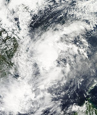
The 2004 Myanmar cyclone was considered the worst to strike the country since 1968. The second tropical cyclone of the 2004 North Indian Ocean cyclone season, it formed as a depression on May 16 in the central Bay of Bengal. With low wind shear and a surge in the monsoon trough, the storm intensified while meandering over open waters. The storm eventually began a steady northeastward motion due to a ridge to the north over India. While approaching land, an eye developed in the center of the storm, indicative of a strong cyclone. On May 19, the cyclone made landfall along northwestern Myanmar near Sittwe, with maximum sustained winds estimated at 165 km/h (105 mph) by the India Meteorological Department. The storm rapidly weakened over land, although its remnants spread rainfall into northern Thailand and Yunnan province in China.

<span class="mw-page-title-main">Cyclone Forrest</span> Pacific tropical storm and North Indian cyclone in 1992

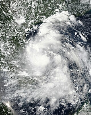
Extremely Severe Cyclonic Storm Forrest, also referred to as Tropical Storm Forrest while in the western Pacific basin before its Thai crossover, was a powerful tropical cyclone that prompted the evacuation of 600,000 people in Bangladesh in late November 1992. Originating from an area of disturbed weather near the Caroline Islands on November 9, Forrest was classified as a tropical depression three days later over the South China Sea. Tracking generally west, the system steadily organized into a tropical storm, passing Vietnam to the south, before striking Thailand along the Malay Peninsula on November 15. Once over the Bay of Bengal, Forrest turned northward on November 17 and significantly intensified. It reached its peak intensity on November 20 as a Category 4-equivalent cyclone on the Saffir–Simpson hurricane scale with winds of 230 km/h (140 mph). Hostile environmental conditions soon affected the cyclone as it turned abruptly east-northeastward. Forrest made landfall in northwestern Myanmar as a weakening system on November 21 before dissipating early the next day.

<span class="mw-page-title-main">Cyclone Komen</span> North Indian cyclone in 2015

Cyclonic Storm Komen was an unusual tropical cyclone that originated near the southern coast of Bangladesh and later struck the same country while drifting over the northern Bay of Bengal. The second named storm of the 2015 season, Komen brought several days of heavy rainfall to Myanmar, Bangladesh, and India. It formed as a depression on July 26 over the Ganges delta and moved in a circular motion around the northern Bay of Bengal. Komen intensified into a 75 km/h (45 mph) cyclonic storm and moved ashore southeastern Bangladesh on July 30. The system turned westward over land and was last noted over eastern India on August 2.

<span class="mw-page-title-main">Typhoon Agnes (1984)</span> Pacific typhoon in 1984

Typhoon Agnes, known in the Philippines as Typhoon Undang, was the fourth final tropical cyclone to affect the Philippines during the 1984 Pacific typhoon season. An area of disturbed weather developed near the equator and the Caroline Islands on October 28. Following an increase in organization, the cyclone was designated a tropical storm on October 31. After tracking northwest initially, Agnes turned west-northwest the next day, a course that the system would maintain for the rest of its lifetime. Agnes intensified into a typhoon on November 2, and on November 4, attained peak intensity. The storm then made landfall on Samar Island, part of the Philippines, at that intensity. The storm weakened over land, but re-intensified over the South China Sea; Agnes obtained a secondary peak intensity on November 6. The next day, Typhoon Agnes moved ashore Vietnam while still at typhoon intensity. The storm rapidly deteriorated over land and dissipated by November 8 over Thailand.

<span class="mw-page-title-main">1994 Bangladesh cyclone</span> Category 4 North Indian tropical cyclone in 1994

The 1994 Bangladesh cyclone was a powerful tropical cyclone in the Bay of Bengal. The cyclone closely followed the path, strength, and time of year of a deadly cyclone in 1991 that killed more than 138,000 people. The 1994 cyclone formed on April 29 as a depression, which organized and intensified significantly over the subsequent few days. On May 2, the cyclone attained winds of 215 km/h (135 mph), according to the India Meteorological Department (IMD). That day, the storm made landfall in southeastern Bangladesh, and rapidly weakened over land, before dissipating on May 3.

<span class="mw-page-title-main">2020 Central Vietnam floods</span> Series of severe rainfall and floods in Central Vietnam in 2020

The 2020 Central Vietnam floods were a series of floods in Central Vietnam, which also affected some areas in Cambodia and Laos in October and early November 2020. The floods focused heavily in several provinces including Thừa Thiên Huế, Hà Tĩnh, Quảng Bình, Quảng Trị, and Quảng Ngãi. The floods were mainly caused by the seasonal monsoon, though enhanced by numerous tropical cyclones.

References

  1. 1 2 3 4 5 6 7 8 Joint Typhoon Warning Center (2001). "1997 Annual Tropical Cyclone Report" (PDF). Archived from the original (PDF) on 2011-06-06. Retrieved 2010-03-22.
  2. The United Nations Task Force on El Niño; et al. (1999). "The 1997-1998 El Niño Event: A Scientific and Technical Retrospect" (PDF). World Meteorological Organization. Archived from the original (PDF) on 2006-03-11. Retrieved 2007-04-19.
  3. 1 2 India Meteorological Department (2008). "Best Tracks Data ( 1990 - 2008)". Archived from the original (XLS) on 2014-09-25. Retrieved 2010-03-22.
  4. 1 2 3 International Federation of Red Cross And Red Crescent Societies (1997). "Typhoon Linda Information Bulletin No. 1". ReliefWeb. Retrieved 2010-03-22.
  5. 1 2 3 4 5 6 United Nations Department of Humanitarian Affairs (1997). "Viet Nam Typhoon Linda Situation Report No. 3". ReliefWeb. Retrieved 2010-03-22.
  6. 1 2 3 United Nations Department of Humanitarian Affairs (1997). "Viet Nam Typhoon Linda Situation Report No. 2". ReliefWeb. Retrieved 2010-03-22.
  7. 1 2 International Federation of Red Cross And Red Crescent Societies (1997). "Devastation caused by Typhoon Linda". ReliefWeb. Retrieved 2010-03-22.
  8. 1 2 3 4 United Nations Department of Humanitarian Affairs (1997). "Vietnam Typhoon Linda Situation Report No. 4". ReliefWeb. Retrieved 2010-03-22.
  9. Le Truong Giang (2005). "Damage Caused by Strong Wind & Wind Loads Standards for Building in Vietnam" (PDF). Tokyo Polytechnic University. Retrieved 2010-03-22.
  10. 1 2 3 4 United Nations Department of Humanitarian Affairs (1997). "Viet Nam Typhoon Linda Situation Report No. 1". ReliefWeb. Retrieved 2010-03-22.
  11. 1 2 United Nations Development Programme (2003). "Summing-up report on disaster situations in recent years and preparedness and mitigation measures in Vietnam". ReliefWeb. Retrieved 2010-03-22.
  12. 1 2 3 "Typhoon Victims' bodies found on Vietnam shores". Reuters. 1997. Retrieved 2010-03-22.
  13. International Federation of Red Cross And Red Crescent Societies (1997). "Typhoon Linda Information Bulletin No. 2". ReliefWeb. Retrieved 2010-03-22.
  14. International Federation of Red Cross And Red Crescent Societies (1997). "Typhoon Linda Information Bulletin No. 3". ReliefWeb. Retrieved 2010-03-22.
  15. The Nation (1997). "The Nation" . Retrieved 2010-03-22.
  16. Agence France-Presse (1997-11-08). "Hanoi's Help Sought to Establish Seamen's Fate" . Retrieved 2010-03-22.
  17. Staff Writer. "Hanoi's help sought to establish seamen's fate". The Nation. Agence France-Presse. Retrieved 2011-07-02.