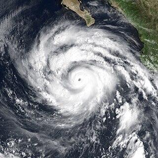
Hurricane Linda was a very powerful Category 5 hurricane that was, at the time, the most intense eastern Pacific hurricane on record until surpassed 18 years later by Patricia. Forming from a tropical wave on September 9, 1997, Linda steadily intensified and reached hurricane status within 36 hours of developing. The storm rapidly intensified, reaching sustained winds of 185 mph (298 km/h) and an estimated central pressure of 902 millibars (26.6 inHg); both were records for the eastern Pacific until Hurricane Patricia surpassed them in 2015. The hurricane was briefly forecast to move toward southern California, but instead, it turned out to sea and lost its status as a tropical cyclone on September 17, before dissipating on September 21. Linda was the fifteenth tropical cyclone, thirteenth named storm, seventh hurricane, and fifth major hurricane of the 1997 Pacific hurricane season. Linda was also the most intense tropical cyclone worldwide in 1997.

The 2005 Pacific hurricane season was a near-average season which produced fifteen named storms, only seven hurricanes formed and two major hurricanes. It was also the second consecutive season in which no tropical cyclone of at least tropical storm intensity made landfall. The season officially began on May 15 in the East Pacific Ocean, and on June 1 in the Central Pacific; they ended on November 30. These dates conventionally delimit the period of each year when most tropical cyclones form in the Pacific basin. However, the formation of tropical cyclones is possible at any time of the year.

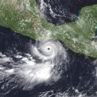
Hurricane Adrian was an early season hurricane which took an unusual southwest to northeast track, bringing it closer to El Salvador than any other hurricane since reliable records began in 1949. The first storm of the 2005 Pacific hurricane season, Adrian developed on May 17, just two days after the official start of the season, several hundred miles south-southeast of Mexico. Tracking in an atypical northwestward direction, the storm gradually intensified. On May 19, the storm reached its peak strength as a minimal hurricane with winds of 80 mph (130 km/h). Not long after reaching this intensity, the storm abruptly weakened. By the morning of May 20, the system had weakened to a minimal tropical storm and turned due west. Later that day, the storm made landfall along the Gulf of Fonseca in Honduras before dissipating several hours later.

The 2000 Pacific hurricane season was an above-average Pacific hurricane season, although most of the storms were weak and short-lived. There were few notable storms this year. Tropical storms Miriam, Norman, and Rosa all made landfall in Mexico with minimal impact. Hurricane Daniel briefly threatened the U.S. state of Hawaii while weakening. Hurricane Carlotta was the strongest storm of the year and the second-strongest June hurricane in recorded history. Carlotta killed 18 people when it sank a freighter. Overall, the season was significantly more active than the previous season, with 19 tropical storms. In addition, six hurricanes developed. Furthermore, there were total of two major hurricanes.

The 1998 Pacific hurricane season was a fairly average Pacific hurricane season. Despite this, it had nine hurricanes and six major hurricanes, which was well above average. The season officially started on May 15 in the eastern Pacific and on June 1 in the central Pacific, and ended on November 30; these dates conventionally delimit the period during which most tropical cyclones form in that region. The first tropical cyclone developed on June 11, about ten days later than the normal start of the season. The final storm of the year, Hurricane Madeline, dissipated on October 20. Storm activity in the Central Pacific Hurricane Center's warning zone was low, with just one tropical depression observed in the region. Two tropical cyclones from the eastern Pacific also entered the central Pacific; the former did so as a hurricane.

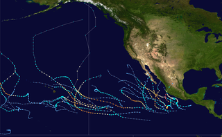
The 1997 Pacific hurricane season was a very active hurricane season. With hundreds of deaths and hundreds of millions of dollars in damage, this was one of the deadliest and costliest Pacific hurricane seasons on record. This was due to the exceptionally strong 1997–98 El Niño event. The season officially started on May 15, in the eastern Pacific, and on June 1, in the central Pacific, and lasted until November 30. These dates conventionally delimit the period of each year when almost all tropical cyclones form in the northeastern Pacific Ocean.

The 1988 Pacific hurricane season was the least active Pacific hurricane season since 1981. It officially began May 15, in the eastern Pacific, and June 1, in the central Pacific and lasted until November 30. These dates conventionally delimit the period of each year when most tropical cyclones form in the northeastern Pacific Ocean. The first named storm, Tropical Storm Aletta, formed on June 16, and the last-named storm, Tropical Storm Miriam, was previously named Hurricane Joan in the Atlantic Ocean before crossing Central America and re-emerging in the eastern Pacific; Miriam continued westward and dissipated on November 2.

The 2008 Pacific hurricane season was a near-average Pacific hurricane season which featured seventeen named storms, though most were rather weak and short-lived. Only seven hurricanes formed and two major hurricanes. This season was also the first since 1996 to have no cyclones cross into the central Pacific. The season officially began on May 15 in the eastern Pacific and on June 1 in the central Pacific. It ended in both regions on November 30. These dates, adopted by convention, historically describe the period in each year when most tropical cyclone formation occurs in these regions of the Pacific. This season, the first system, Tropical Storm Alma, formed on May 29, and the last, Tropical Storm Polo, dissipated on November 5.
Tropical Storm Barbara was the first tropical cyclone to make landfall during the 2007 Pacific hurricane season. The second storm of the season, Barbara developed from a small low-pressure area on May 29 about 235 miles (380 km) southeast of Acapulco, Mexico. The system drifted southward before turning to a steadily eastward motion, and quickly intensified into a tropical storm. Increased wind shear weakened Barbara, though it re-organized to attain peak winds of 50 mph (80 km/h) before moving ashore just west of the border of Mexico and Guatemala. It rapidly weakened over land, and on June 2 the National Hurricane Center discontinued advisories on the storm. Despite expectations that the storm would attain hurricane status, Barbara moved ashore as a small, weak tropical storm. It produced locally heavy rainfall and gusty winds, and in most locations damage was minor. However, in southern Mexico, the rainfall destroyed large areas of cropland, with crop damage totaling 200 million pesos. In El Salvador, four people were killed by storm-induced floods.
Tropical Storm Barry was a rapidly forming tropical cyclone that made landfall on Florida, United States, in early June 2007. The second named storm of the 2007 Atlantic hurricane season, Barry developed from a trough of low pressure in the southeastern Gulf of Mexico on June 1. It tracked rapidly northeastward, reaching peak winds of 60 mph (97 km/h) before weakening and making landfall near Tampa Bay as a tropical depression. Barry quickly lost tropical characteristics after wind shear removed much of the convection, and early on June 3, it completed the transition into an extratropical cyclone. The extratropical remnants tracked up the East Coast of the United States, and were absorbed by a larger extratropical cyclone on June 5.
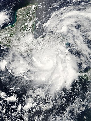
Hurricane Lester was a small but powerful tropical cyclone that caused heavy flooding in Central America and southern Mexico in October 1998. Lester was the fifteenth tropical cyclone, twelfth named storm and eighth hurricane of the 1998 Pacific hurricane season. Lester originated from a tropical wave that emerged off the coast of Africa on September 29. Under favorable conditions, the storm was classified as a tropical depression on October 15. The depression was upgraded to a tropical storm later that day and a hurricane on October 16. After undergoing fluctuations in intensity, Lester reached peak winds of 115 mph (185 km/h), a Category 3 hurricane on the Saffir-Simpson Hurricane Scale. After several days, it degenerated into a tropical storm on October 26, and dissipated shortly after. The hurricane made its closest approach to land on October 28, producing moderate winds and heavy rainfall. A mudslide triggered by the precipitation killed two children, although damage is unknown.
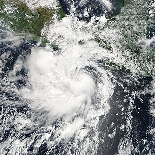
Tropical Storm Alma of the 2008 Pacific hurricane season was the easternmost forming Pacific tropical cyclone on record. It formed within the monsoon trough just off the coast of Costa Rica on May 29. Initially forecast to remain a weak tropical storm, the cyclone rapidly strengthened and developed an eye, before making landfall on May 29 in Nicaragua, near León, with peak winds of 65 mph (105 km/h). Alma degenerated into a remnant low on May 30, before merging with another approaching tropical wave in the Gulf of Honduras shortly afterward, which became Tropical Storm Arthur on the next day. Alma was the first tropical storm on record to strike the Pacific coast of Nicaragua. In Costa Rica, heavy rainfall caused flooding and landslides, killing two and causing $35 million (USD) in damage. Three people were killed in Nicaragua, one from drowning and two others from electrocution. Five others died in Honduras from an aviation accident likely related to the storm and one other was swept away in floodwaters.

Hurricane Bridget of June 1971 was one of the worst hurricanes to strike the Mexican city of Acapulco. It formed on June 14 as a tropical depression, which is a minimal tropical cyclone with winds less than gale force. However, it was soon upgraded to a tropical storm, and Bridget steadily intensified to become a hurricane on June 15. After peaking at Category 2 intensity, it weakened to a tropical storm on June 17, then made landfall in Mexico. Hours later, however, it turned offshore as a tropical depression. Bridget dissipated on June 20 after leaving heavy damage and 17 deaths in the Acapulco area.
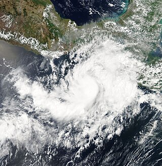
Tropical Storm Odile was a late season tropical storm that formed during the 2008 Pacific hurricane season and affected parts of southern Mexico. A tropical depression formed on October 8, and became Tropical Storm Odile 18 hours later. The storm paralleled the south coast of Mexico, with the center located only several miles offshore. After peaking in intensity, increasing southeasterly vertical wind shear induced a trend of rapid weakening on the storm. Correspondingly, Odile was downgraded to a tropical depression early on 12 October, subsequently degenerating into a remnant low about 55 mi (85 km) south of Manzanillo, Colima. From thereon, the low proceeded slowly south-southwestward before dissipating on October 13. Since Odile stayed at sea, its effects along coastlines were limited. The most notable damages were caused by flooding along the southern coast of Mexico, mostly in Chiapas, Oaxaca, Guerrero and Michoacán. The exact amount of damage, however, remains unknown, and no fatalities were reported as a result of the storm.

Hurricane Ida was the strongest landfalling tropical cyclone during the 2009 Atlantic hurricane season, crossing the coastline of Nicaragua with winds of 80 mph (130 km/h). The remnants of the storm became a powerful nor'easter that caused widespread damage along coastal areas of the Mid-Atlantic States. Ida formed on November 4 in the southwestern Caribbean, and within 24 hours struck the Nicaragua coast with winds of 80 mph (130 km/h). It weakened significantly over land, although it restrengthened in the Yucatán Channel to peak winds of 105 mph (170 km/h). Hurricane Ida weakened and became an extratropical cyclone in the northern Gulf of Mexico, before spreading across the southeastern United States. The remnants of Ida contributed to the formation of a nor'easter that significantly affected the eastern coast of the United States.

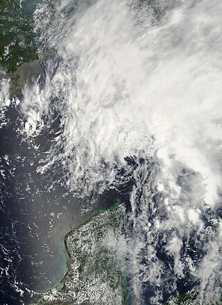
Tropical Storm Olaf was an erratic and long-lived tropical cyclone that brought heavy rainfall to regions of Mexico, which would be devastated by Hurricane Pauline a week later. The sixteenth named storm of the 1997 season, Olaf formed on September 26 off the southern coast of Mexico. It moved northward and quickly intensified, reaching peak winds of 70 mph (110 km/h) before weakening and hitting Oaxaca as a tropical depression. In Mexico, El Salvador, and Guatemala, the system brought heavy rainfall, which killed 18 people and caused flooding and damage. It was originally thought that Olaf dissipated over Mexico, although its remnants continued westward for a week. It interacted with Hurricane Pauline, which caused Olaf to turn to the southeast and later to the north to strike Mexico again, finally dissipating on October 12.
The 2015 Pacific hurricane season is the second-most active Pacific hurricane season on record, with 26 named storms, only behind the 1992 season. A record-tying 16 of those storms became hurricanes, and a record 11 storms further intensified into major hurricanes throughout the season. The Central Pacific, the portion of the Northeast Pacific Ocean between the International Date Line and the 140th meridian west, had its most active year on record, with 16 tropical cyclones forming in or entering the basin. Moreover, the season was the third-most active season in terms of accumulated cyclone energy, amassing a total of 290 units. The season officially started on May 15 in the Eastern Pacific and on June 1 in the Central Pacific; they both ended on November 30. These dates conventionally delimit the period of each year when most tropical cyclones form in the Northeast Pacific basin. However, the formation of tropical cyclones is possible at any time of the year. This was shown when a tropical depression formed on December 31. The above-average activity during the season was attributed in part to the very strong 2014–16 El Niño event.

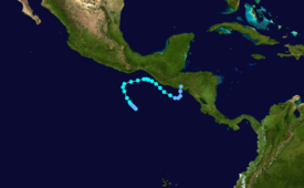
Tropical Storm Selma was the first tropical storm on record to make landfall in El Salvador, and only the second Pacific tropical cyclone to attain tropical storm strength east of 90°W, the other being Alma of 2008. The twentieth tropical cyclone and eighteenth named storm of the 2017 Pacific hurricane season, Selma formed from a Central American gyre on October 27. The storm tracked northeastward and reached its peak intensity as a minimal tropical storm before making landfall east of San Salvador, El Salvador early on October 28. Selma rapidly weakened after making landfall, and its remnant circulation dissipated overland at 18:00 UTC on the same day.

The 2020 Pacific hurricane season was the least active Pacific hurricane season since 2011. Altogether, 21 tropical cyclones developed. The season was near average in terms of tropical storms, featuring a total of 17, but had a well below average number of hurricanes and major hurricanes, with only 4 hurricanes and 3 major hurricanes forming. Additionally, no tropical cyclones formed in the Central Pacific basin for the first time since 2017, marking the start of a series of seasons with no tropical cyclogenesis occurring there. The season officially began on May 15 in the East Pacific Ocean, and on June 1 in the Central Pacific (from 140°W to the International Date Line, north of the equator; they both ended on November 30. These dates conventionally delimit the period of each year when most tropical cyclones form in the respective regions. However, the formation of tropical cyclones is possible at any time of the year, as illustrated in 2020 by the formation of the season's first system, Tropical Depression One-E, on April 25. This the earliest formation of a tropical cyclone on record in the eastern Pacific basin proper.

Tropical Storm Amanda and Tropical Storm Cristobal were two related, consecutive tropical storms that affected Central America, southern Mexico, the Central United States, and Canada in late May and early June 2020. The first tropical cyclone formed in the East Pacific and was named Amanda. After crossing Central America, it regenerated into a second one in the Gulf of Mexico and was named Cristobal. Amanda was the second tropical depression and the first named storm of the 2020 Pacific hurricane season, and Cristobal was the third named storm of the extremely active 2020 Atlantic hurricane season, and the earliest third named storm in the North Atlantic Ocean on record. Cristobal's regeneration date in the North Atlantic eclipsed the date set by Tropical Storm Colin in 2016, which formed on June 5. It was also the first Atlantic tropical storm formed in the month of June since Cindy in 2017, and the first June tropical cyclone to make landfall in Mexico since Danielle in 2016.