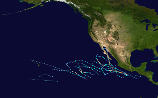
The 2001 Pacific hurricane season was a relatively near-average Pacific hurricane season which produced fifteen named storms, though most were rather weak and short-lived. Only eight hurricanes formed and two major hurricanes. The season officially began on May 15 in the East Pacific Ocean, and on June 1 in the Central Pacific; they ended on November 30. These dates conventionally delimit the period of each year when most tropical cyclones form in the Pacific basin. However, the formation of tropical cyclones is possible at any time of the year.

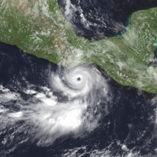
Hurricane Juliette was a powerful Pacific hurricane that struck Mexico in September 2001. A long-lived tropical cyclone, Juliette originated from a tropical wave that exited western Africa, the same wave that earlier spawned Atlantic Tropical Depression Nine near Nicaragua on September 19. Two days later, a new tropical depression developed offshore Guatemala, which became Hurricane Juliette by September 22 as it rapidly intensified off western Mexico. On September 24 it strengthened into a Category 4 hurricane on the Saffir-Simpson scale, only to weaken due to an eyewall replacement cycle, then re-intensified a day later to attain maximum sustained winds of 230 km/h (145 mph), with a minimum barometric pressure of 923 mbar (27.3 inHg). Juliette weakened as it moved toward the Baja California peninsula, producing hurricane-force winds and torrential rainfall across Baja California Sur. On September 30 after the hurricane had weakened, Juliette made landfall near San Carlos as a minimal tropical storm. After drifting across the Gulf of California, Juliette dissipated on October 3.

Hurricane Javier was a powerful tropical cyclone whose remnants brought above-average rainfall totals across the western United States in September 2004. Javier was the tenth named storm, the sixth hurricane and the final major hurricane of the 2004 Pacific hurricane season. Javier was also the strongest hurricane of the 2004 season, with 150 mph (240 km/h) winds and a central pressure of 930 millibars. However, because of high wind shear in the East Pacific, Javier weakened rapidly before making landfall in Baja California as a tropical depression. The remnants of the storm then continued moving northeast through the Southwestern United States. Javier caused no direct fatalities, and the damage in Mexico and the United States was minimal.

Hurricane Adolph was the first and one of only two East Pacific hurricanes in May to reach Category 4 strength on the Saffir-Simpson Hurricane Scale since record keeping began in the East Pacific, with the other being Amanda of 2014. Adolph was the first depression of the season, forming on May 25; it became a hurricane two days later. After rapidly intensifying, Adolph became the most powerful storm in terms of maximum sustained winds this season, along with Hurricane Juliette. The storm briefly threatened land before dissipating on June 1, after moving over colder waters.

The 2012 Pacific hurricane season was a moderately active Pacific hurricane season that saw an unusually high number of tropical cyclones pass west of the Baja California Peninsula. The season officially began on May 15 in the eastern Pacific Ocean, and on June 1 in the central Pacific (from 140°W to the International Date Line, north of the equator; they both ended on November 30. These dates conventionally delimit the period of each year when most tropical cyclones form in these regions of the Pacific Ocean. However, the formation of tropical cyclones is possible at any time of the year. This season's first system, Tropical Storm Aletta, formed on May 14, and the last, Tropical Storm Rosa, dissipated on November 3.

Hurricane Madeline was a costly tropical cyclone whose remnants caused hundreds of millions of dollars in damage in Texas in October 1998. The final tropical cyclone of the 1998 Pacific hurricane season, Madeline originated from a tropical wave that emerged off the coast of Africa on September 25, 1998. The wave traversed the Atlantic Ocean and crossed over Central America on October 5 or 6. Gradually, the system intensified and was classified as a tropical depression on October 16, a tropical storm later that day, and a hurricane on October 17. The storm reached peak winds of 85 mph (137 km/h) about 95 miles (153 km) southwest of San Blas, Nayarit, and after 18 hours it subsequently began to weaken. Although Madeline never made landfall, numerous rainbands affected the Mexican coast causing no known damage or fatalities. The remnant moisture moved north and contributed to flooding in central Texas, which killed 31 people and caused $750 million in damage.
Hurricane Lester was a small but powerful tropical cyclone that caused heavy flooding in Central America and southern Mexico in October 1998. Lester was the fifteenth tropical cyclone, twelfth named storm and eighth hurricane of the 1998 Pacific hurricane season. Lester originated from a tropical wave that emerged off the coast of Africa on September 29. Under favorable conditions, the storm was classified as a tropical depression on October 15. The depression was upgraded to a tropical storm later that day and a hurricane on October 16. After undergoing fluctuations in intensity, Lester reached peak winds of 115 mph (185 km/h), a Category 3 hurricane on the Saffir-Simpson Hurricane Scale. After several days, it degenerated into a tropical storm on October 26, and dissipated shortly after. The hurricane made its closest approach to land on October 28, producing moderate winds and heavy rainfall. A mudslide triggered by the precipitation killed two children, although damage is unknown.

Tropical Storm Norman was a weak tropical cyclone that brought heavy rainfall to southwestern Mexico in October 2006. The fifteenth named storm of the 2006 Pacific hurricane season, Norman developed on October 9 from a tropical wave well to the southwest of Mexico. Unfavorable conditions quickly encountered the system, and within two days of forming, Norman dissipated as its remnants turned to the east. Thunderstorms gradually increased again, as it interacted with a disturbance to its east, and on October 15 the cyclone regenerated just off the coast of Mexico. The center became disorganized and quickly dissipated, bringing a large area of moisture which dropped up to 6 inches (150 mm) of rainfall to southwestern Mexico. Rainfall from the storm flooded about 150 houses, of which 20 were destroyed. One person was injured, and initially there were reports of two people missing due to the storm; however, it was not later confirmed.

The 2006 Pacific hurricane season was the first above-average season since 1997 which produced twenty-five tropical cyclones, with nineteen named storms, though most were rather weak and short-lived. There were eleven hurricanes, of which six became major hurricanes. Following the inactivity of the previous seasons, forecasters predicted that season would be only slightly above active. It was also the first time since 2003 in which one cyclone of at least tropical storm intensity made landfall. The season officially began on May 15 in the East Pacific Ocean, and on June 1 in the Central Pacific; they ended on November 30. These dates conventionally delimit the period of each year when most tropical cyclones form in the Pacific basin. However, the formation of tropical cyclones is possible at any time of the year.

Hurricane Hernan was the fourth and final tropical cyclone to strike Mexico at hurricane intensity during the 1996 Pacific hurricane season. The thirteenth tropical cyclone, eighth named storm, and fifth hurricane of the season, Hernan developed as a tropical depression from a tropical wave to the south of Mexico on September 30. The depression quickly strengthened, and became Tropical Storm Hernan later that day. Hernan curved north-northwestward the following day, before eventually turning north-northeastward. Still offshore of the Mexican coast on October 2, Hernan intensified into a hurricane. Six hours later, Hernan attained its peak as an 85 mph (140 km/h) Category 1 hurricane on the Saffir-Simpson Hurricane Wind Scale (SSHWS). After weakening somewhat, on 1000 UTC October 3, Hurricane Hernan made landfall near Barra de Navidad, Jalisco, with winds of 75 mph (120 km/h). Only two hours after landfall, Hernan weakened to a tropical storm. By October 4, Tropical Storm Hernan had weakened into a tropical depression, and dissipated over Nayarit on the following day.

Tropical Depression Five-E was a tropical depression which made landfall along the south-western Mexican coastline in July 2008. It was the fifth tropical cyclone of the 2008 Pacific hurricane season. The depression developed out of a weak tropical wave which formed off the coast of Africa on June 23. The wave remained poorly organized throughout its journey through the Atlantic Ocean and Caribbean Sea. The wave entered the Eastern Pacific on July 2 after passing through Central America. The wave developed into an area of low pressure that afternoon.

Hurricane Barbara was the easternmost landfalling Pacific hurricane on record. As the first hurricane of the 2013 Pacific hurricane season, Barbara developed from a low-pressure area while located southeast of Mexico on May 28. It headed slowly north-northeastward and strengthened into a tropical storm early on the following day. After recurving to the northeast, Barbara intensified into a Category 1 hurricane on May 29 and made landfall in Chiapas at peak intensity with winds of 80 mph (130 km/h) and a barometric pressure estimated at 983 mbar. When the hurricane made landfall, it was the second earliest landfalling hurricane in the basin since reliable records began in 1966. Barbara then moved across the Isthmus of Tehuantepec and dissipated within the mountainous terrain of Sierra Madre de Chiapas on May 30.

Tropical Storm Carlos was the first of five tropical cyclones to make landfall during the 2003 Pacific hurricane season. It formed on June 26 from a tropical wave to the south of Mexico. It quickly strengthened as it approached the coast, and early on June 27 Carlos moved ashore in Oaxaca with winds of 65 mph (105 km/h). The storm rapidly deteriorated to a remnant low, which persisted until dissipating on June 29. Carlos brought heavy rainfall to portions of southern Mexico, peaking at 337 mm (13.3 in) in two locations in Guerrero. Throughout its path, the storm damaged about 30,000 houses, with a monetary damage total of 86.7 million pesos. At least nine people were killed throughout the country, seven due to mudslides and two from river flooding; there was also a report of two missing fishermen.

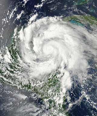
Hurricane Rick was the third-most intense Pacific hurricane on record and the second-most intense tropical cyclone worldwide in 2009, only behind Typhoon Nida. Developing off the southern coast of Mexico on October 15, Rick traversed an area with favorable environmental conditions, favoring rapid intensification, allowing it to become a hurricane within 24 hours of being declared a tropical depression. An eye began to form during the afternoon of October 16; once fully formed, the storm underwent another period of rapid strengthening. During the afternoon of October 17, the storm attained Category 5 status on the Saffir–Simpson hurricane wind scale. Several hours later, Rick attained its peak intensity as the third-strongest Pacific hurricane on record with winds of 180 mph (290 km/h) and a barometric pressure of 906 mbar.

The 2017 Pacific hurricane season was an above average Pacific hurricane season in terms of named storms, though less active than the previous three, featuring eighteen named storms, nine hurricanes, and four major hurricanes. Despite the considerable amount of activity, most of the storms were weak and short-lived. The season officially started on May 15 in the eastern Pacific Ocean, and on June 1 in the central Pacific; they both ended on November 30. These dates conventionally delimit the period of each year when most tropical cyclones form in the respective regions. However, the formation of tropical cyclones is possible at any time of the year, as illustrated in 2017 by the formation of the season's first named storm, Tropical Storm Adrian, on May 9. At the time, this was the earliest formation of a tropical storm on record in the eastern Pacific basin proper. The season saw near-average activity in terms of accumulated cyclone energy (ACE), in stark contrast to the extremely active seasons in 2014, 2015, and 2016; and for the first time since 2012, no tropical cyclones formed in the Central Pacific basin. However, for the third year in a row, the season featured above-average activity in July, with the ACE value being the fifth highest for the month. Damage across the basin reached $375.28 million (2017 USD), while 45 people were killed by the various storms.

Hurricane Beatriz was a Category 1 hurricane that killed four people after brushing the western coast of Mexico in June 2011. The second named storm and hurricane of the 2011 Pacific hurricane season, Beatriz originated from an area of disturbed weather on June 19, several hundred miles south of Mexico, and gradually intensified. Gaining latitude, the system became increasingly organized and reached hurricane status on the evening of June 20. The following morning, Beatriz attained winds of 90 mph (150 km/h) as it passed roughly 15 mi (20 km) of Mexico. Due to its interaction with land, the hurricane abruptly weakened hours later. Early on June 22, Beatriz dissipated over open waters. Prior to Beatriz's arrival in Mexico, hurricane watches and warnings were issued for coastal areas. Hundreds of shelters opened across the states of Colima and Guerrero. Heavy rains from the storm triggered significant flooding along the Sabana River in Acapulco, killing four people. However, the overall effects of Beatriz were limited and the rains were largely beneficial in mitigating a severe drought.

Hurricane Adrian was an intense, albeit short-lived early-season Category 4 hurricane that brought heavy rainfall and high waves to Mexico in June 2011 during the 2011 Pacific hurricane season. Adrian originated from an area of disturbed weather which had developed during the course of early June, off the Pacific coast of Mexico. On June 7, it acquired a sufficiently organized structure with deep convection to be classified as a tropical cyclone, and the National Hurricane Center (NHC) designated it as Tropical Depression One-E, the first one of 2011. It further strengthened to be upgraded into a tropical storm later that day. Adrian moved rather slowly; briefly recurving northward after being caught in the steering winds. After steady intensification, it was upgraded into a hurricane on June 9. The storm subsequently entered a phase of rapid intensification, developing a distinct eye with good outflow in all quadrants. Followed by this period of rapid intensification, it obtained sustained winds fast enough to be considered a major hurricane and reached its peak intensity as a category 4 hurricane that evening.

Tropical Storm Don was the first tropical cyclone to make landfall in the United States during the 2011 season. The fourth named storm of the 2011 Atlantic hurricane season, Tropical Storm Don formed from an area of low pressure along a tropical wave, Don developed into a tropical depression on July 27, and on that same day, was upgraded to tropical storm intensity, based on data from a reconnaissance aircraft noted the presence of tropical-storm-force winds. It tracked across the Gulf of Mexico and reached a peak intensity of 50 mph (85 km/h) before moving ashore in Texas on July 30 as a tropical depression, dissipating shortly afterwards. Initially, Don was expected to provide relief to the state, which was suffering from a major drought. However, the system dissipated rapidly just before making landfall, providing very little in the way of help to the state; rainfall totals were less than 1 in (25 mm).
Hurricane Ernesto was a Category 2 hurricane and a damaging tropical cyclone that affected several Caribbean Islands and areas of Central America during August 2012. The fifth named storm and second hurricane of the 2012 Atlantic hurricane season, Ernesto originated from a tropical wave that emerged off the west coast of Africa in late July. Moving westward, the system developed into a tropical depression in the central Atlantic, and further into a tropical storm prior to entering the Caribbean Sea. The system encountered high wind shear south of Jamaica but subsequently reached its peak intensity as a Category 2 hurricane as it made landfall on the Yucatán Peninsula. Ernesto briefly emerged in the Bay of Campeche as a strong tropical storm before dissipating over the mountainous terrain of Mexico. The remnant circulation emerged in the eastern Pacific basin, contributing to the formation of Tropical Storm Hector.

Hurricane Max was a rapidly-forming tropical cyclone that made landfall in southwestern Mexico, causing minor damage. The sixteenth tropical cyclone, thirteenth named storm, and seventh hurricane of the 2017 Pacific hurricane season, Max developed from a trough of low pressure near the southwestern coast of Mexico on September 13. The storm tracked northeastward under the influence of a mid-level ridge and rapidly strengthened as a result of warm ocean temperatures in its path. Max strengthened into a hurricane on September 14 and peaked as a high-end Category 1 hurricane on the Saffir–Simpson scale shortly before making landfall in the Mexican state of Guerrero. Rapid weakening ensued as Max moved over the mountainous terrain of Mexico, and it weakened below hurricane strength early on September 15. At 12:00 UTC that day, Max dissipated over the mountains of southern Mexico.


