
The 1958 Atlantic hurricane season included every tropical cyclone either affecting or threatening land. There were ten named storms as well as one pre-season tropical storm. Seven of the storms became hurricanes, including five that were major hurricanes, or the equivalent of a Category 3 on the Saffir-Simpson scale. The strongest storm was Hurricane Helene, which became a strong Category 4 hurricane with 150 mph (240 km/h) winds and a barometric pressure of 930 millibars (27 inHg) while just offshore the southeastern United States.
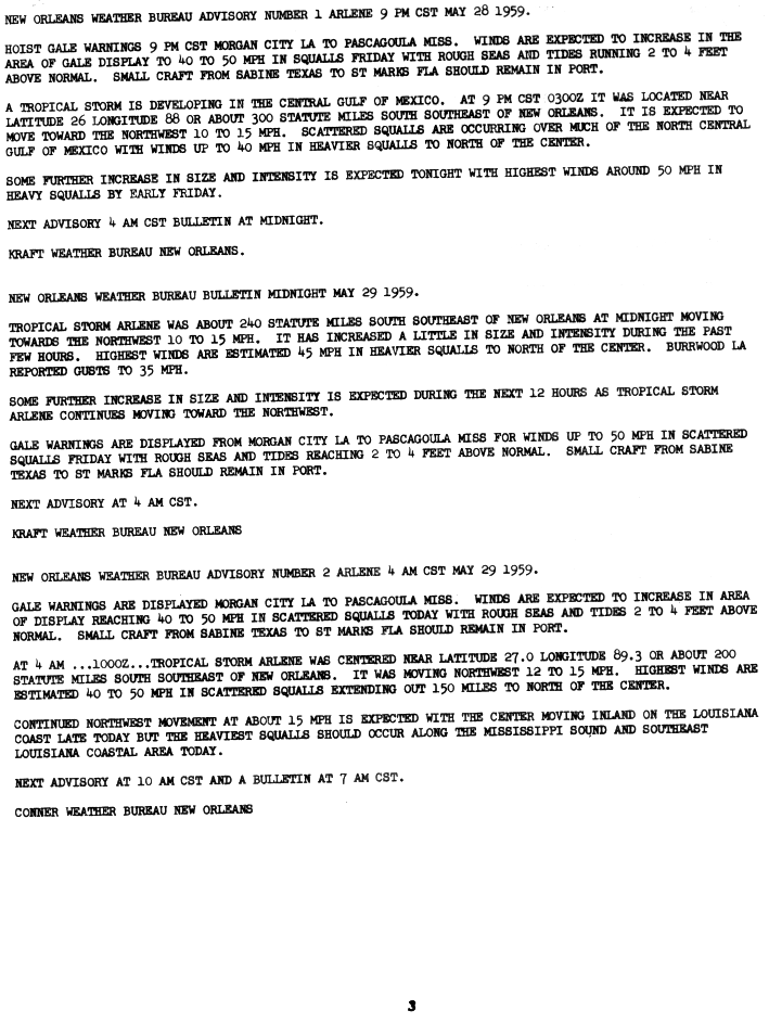
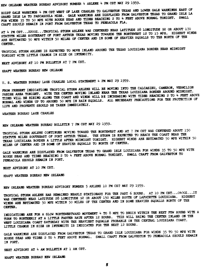
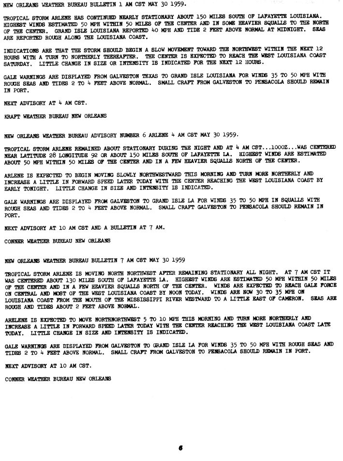
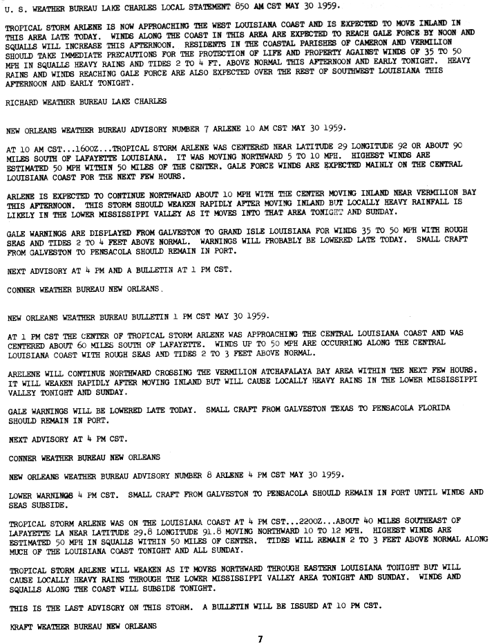
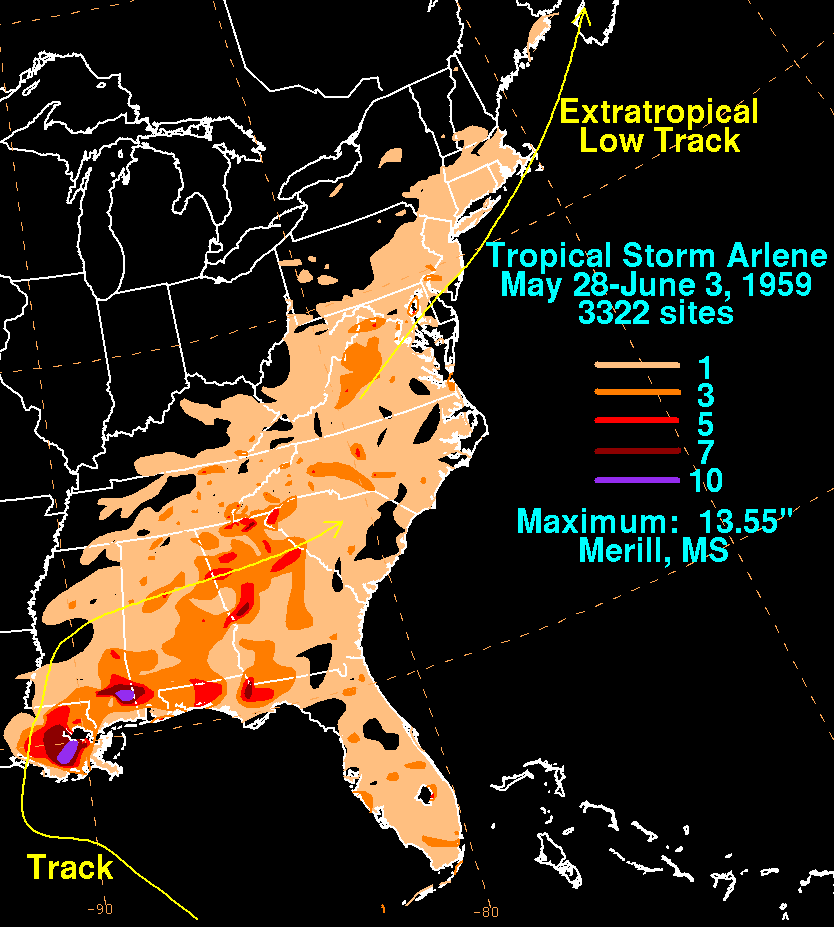
The 1959 Atlantic hurricane season had a then record-tying number of tropical cyclones – five – develop before August 1. The season was officially to begin on June 15, 1959 and last until November 15, 1959, the period of each year when most tropical cyclones form in the Atlantic basin, however in actuality the season began early when Tropical Storm Arlene formed on May 28. Tropical Storm Arlene struck Louisiana and brought minor flooding to the Gulf Coast of the United States. The next storm, Beulah, formed in the western Gulf of Mexico and brought negligible impact to Mexico and Texas. Later in June, an unnamed hurricane, nicknamed the Escuminac disaster, caused minor damage in Florida and devastated coastal Nova Scotia and New Brunswick, after becoming extratropical. Hurricane Cindy brought minor impact to The Carolinas. In late July, Hurricane Debra produced flooding in the state of Texas. Tropical Storm Edith in August and Hurricane Flora in September caused negligible impact on land.

The 1960 Atlantic hurricane season was the least active season since 1952. The season officially began on June 15, and lasted until November 15. These dates conventionally delimit the period of each year when most tropical cyclones form in the Atlantic basin. The first system, an unnamed storm, developed in the Bay of Campeche on June 22. It brought severe local flooding to southeastern Texas and was considered the worst disaster in some towns since a Hurricane in 1945. The unnamed storm moved across the United States for almost a week before dissipating on June 29. In July, Hurricane Abby resulted in minor damage in the Leeward Islands, before impacting a few Central American counties — the remnants of the storm would go on to form Hurricane Celeste in the East Pacific. Later that month, Tropical Storm Brenda caused flooding across much of the East Coast of the United States. The next storm, Hurricane Cleo, caused no known impact, despite its close proximity to land.

The 1963 Atlantic hurricane season featured one of the deadliest tropical cyclones on record in the Atlantic basin: Hurricane Flora. The season officially began on June 15, and lasted until November 15. These dates conventionally delimit the period of each year when most tropical cyclones form in the Atlantic basin. It was a slightly below average season in terms of tropical storms, with a total of ten nameable storms. The first system, an unnamed tropical storm, developed over the Bahamas on June 1. In late July, Hurricane Arlene, developed between Cape Verde and the Lesser Antilles. The storm later impacted Bermuda, where strong winds resulted in about $300,000 (1963 USD) in damage. Other storms such as hurricanes Beulah and Debra, as well as an unnamed tropical storm, did not impact land. During the month of September, Tropical Storm Cindy caused wind damage and flooding in Texas, leaving three deaths and approximately $12.5 million in damage. Hurricane Edith passed through the Lesser Antilles and the eastern Greater Antilles, causing 10 deaths and about $43 million in damage, most of which occurred on Martinique.

The 1969 Atlantic hurricane season was the most active Atlantic hurricane season since the 1933 season, and was the final year of the most recent positive ("high-quality") Atlantic multidecadal oscillation (AMO) era. The hurricane season officially began on June 1, and lasted until November 30. The season had the highest number of systems reach hurricane status – twelve – in a single season, until that record was surpassed in 2005. The season was above-average despite an El Niño, which typically suppresses activity in the Atlantic Ocean, while increasing tropical cyclone activity in the Pacific Ocean. Activity began with a tropical depression that caused extensive flooding in Cuba and Jamaica in early June. On July 25, Tropical Storm Anna developed, the first named storm of the season. Later in the season, Tropical Depression Twenty-Nine caused severe local flooding in the Florida Panhandle and southwestern Georgia in September.

The 1936 Atlantic hurricane season was a fairly active season, with 20 tropical cyclones recorded, 17 of which became tropical storms. Seven storms became hurricanes, of which one became a major hurricane. In addition, the season was unusual in the fact that no storms moved across large portions of the Caribbean Sea. Seven storms, including three hurricanes, struck the United States.

Tropical Storm Cindy was a strong tropical storm which impacted portions of the United States Gulf Coast in September 1963. The third named storm of the 1963 Atlantic hurricane season, Cindy developed within a trough as a tropical storm in the Gulf of Mexico on 16 September. The disturbance quickly intensified, with a distinct eye becoming visible on satellite imagery as it drifted north-northwestwards toward the Texas coastline. After peaking with 1-minute maximum sustained winds of 65 mph (100 km/h), it made landfall at High Island on the morning of 17 September at peak strength with an atmospheric pressure of 997 mbar. Cindy remained nearly stationary for almost a day, dropping copious rainfall over the Texas coastal plain, before finally turning west-southwestward and dissipating west of Corpus Christi on 20 September.

Tropical Storm Chris caused minor flooding along the Gulf Coast of the United States in September 1982. The fifth tropical or subtropical cyclone and third named storm of the 1982 Atlantic hurricane season, Chris developed from a surface low-pressure area in the northern Gulf of Mexico on September 9. Although initially displaying subtropical characteristics, the low pressure area gradually acquired tropical characteristics, and was reclassified as Tropical Depression Four within 24 hours of development. The depression then began to intensify and was upgraded to Tropical Storm Chris on September 10. Thereafter, the storm turned north-north-eastward and strengthened further. On September 11, Chris peaked as a 65 mph (100 km/h) tropical storm. Later that day, it made landfall near Sabine Pass, Port Arthur, Texas. By September 13, Chris dissipated over Arkansas.

Hurricane Humberto was a Category 1 hurricane that formed and intensified faster than any other North Atlantic tropical cyclone on record, before landfall. The ninth named storm and third hurricane of the 2007 Atlantic hurricane season, Humberto developed on September 12, 2007, in the northwestern Gulf of Mexico,. The tropical cyclone rapidly strengthened and struck High Island, Texas, with winds of about 90 mph (140 km/h) early on September 13. It steadily weakened after moving ashore, and on September 14, Humberto began dissipating over northwestern Georgia as it interacted with an approaching cold front.
Tropical Storm Felice was a modest tropical cyclone that lightly affected parts of the Gulf Coast of the United States in mid-September 1970. Spawned by an upper-level trough over the Bahamas, the system crossed the Florida Keys and entered the Gulf of Mexico, where it gradually began to strengthen. Felice was a disorganized storm for its entire duration, plagued by dry air, a lack of deep thunderstorm activity, and an ill-defined center of circulation, but nevertheless managed to peak as a high-end tropical storm with winds just below Category 1 hurricane strength. Tracking northwestward, the storm brushed southern Louisiana on September 15 before making landfall northeast of Galveston, Texas, late that same day. Once ashore, Felice quickly deteriorated as it recurved into the central United States. While over southeastern Oklahoma, however, its remnants still closely resembled a formidable tropical cyclone.

Tropical Storm Becky was the second tropical cyclone and named storm of the 1970 Atlantic hurricane season. Becky formed from a tropical depression that was designated on July 19. The next day it organized over the Yucatán Channel and became Tropical Storm Becky. Initially thought to have attained minimal hurricane status, Becky reached peak winds of 65 mph (100 km/h), but the storm began to deteriorate shortly thereafter. The storm made landfall on the Florida Panhandle on July 22, and rapidly weakened over land. Overall, damage was related to heavy rainfall that caused flooding in Tallahassee, Florida; 104 families suffered flood-related losses. About $500,000 in damage was attributed to the storm. Further north, the heavy rainfall swelled rivers. Becky may have been partially responsible for spawning tornadoes that destroyed or damaged several houses.

Tropical Storm Debbie of the 1965 Atlantic hurricane season broke the daily rainfall record in Mobile, Alabama, despite dissipating offshore. It developed on September 24 in the western Caribbean Sea, and moved northwestward for several days without intensifying. On September 27, Debbie turned toward the northeast in the Gulf of Mexico, and the next day briefly attained tropical storm status. However, the intrusion of cooler air imparted weakening, and the storm dissipated on September 30 just off the east coast of Louisiana. It initially threatened areas of Louisiana that sustained significant damage from Hurricane Betsy in early September, although Debbie only caused light rainfall and some flooding in the state. In southern Alabama, the storm dropped 17.2 in (440 mm) of rainfall, which resulted in significant flooding of roads and cars. Damage totaled $25 million in the Mobile, Alabama area, although there was little damage elsewhere.

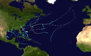
The 2020 Atlantic hurricane season featured a total of 31 tropical or subtropical cyclones, making it the most active Atlantic hurricane season on record. All but one cyclone became a named storm. Of the 30 named storms, 14 developed into hurricanes, and a record-tying seven further intensified into major hurricanes. It was the second and final season to use the Greek letter storm naming system, the first being 2005, the previous record. Of the 30 named storms, 11 of them made landfall in the contiguous United States, breaking the record of nine set in 1916. During the season, 27 tropical storms established a new record for earliest formation date by storm number. This season also featured a record 10 tropical cyclones that underwent rapid intensification, tying it with 1995, as well as tying the record for most Category 4 hurricanes in a singular season in the Atlantic Basin. This unprecedented activity was fueled by a La Niña that developed in the summer months of 2020 as it did, continue a stretch of above-average seasonal activity that began in 2016. Despite the record-high activity, this was the first season since 2015 in which no Category 5 hurricane formed.

The 1901 Louisiana hurricane was the first hurricane to make landfall in Louisiana in the month of August or earlier since 1888. The fourth tropical cyclone and second hurricane of the season, this storm developed southwest of the Azores on August 2. Moving southwestward and later westward, the depression remained weak for several days, until strengthening into a tropical storm while approaching the Bahamas early on August 9. It then crossed through the islands and intensified only slightly. Late on August 10, the storm made landfall near Deerfield Beach, Florida. After reaching the Gulf of Mexico the next day, continuous intensifying occurred and by August 12, the storm reached hurricane status. Peaking with winds of 90 mph (145 km/h), it struck Louisiana late on August 14 and then Mississippi less than 24 hours later. The system weakened to a tropical storm early on August 16 and became extratropical several hours later.
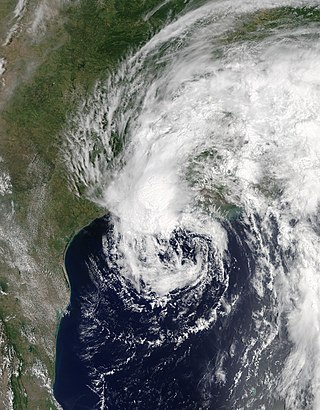
Tropical Storm Cindy was an Atlantic hurricane which became the first tropical cyclone to make landfall in Louisiana since Hurricane Isaac in 2012. The third named storm of the extremely active 2017 Atlantic hurricane season, Cindy formed out of a broad area of low pressure that developed in the northwestern Caribbean Sea near the Yucatán Peninsula in mid-June 2017. The disturbance gradually organized as it drifted northwards into the Gulf of Mexico, and was first designated as a potential tropical cyclone by the National Hurricane Center on June 19, before organizing into a tropical storm the next day. While slowly moving to the northwest, Cindy's intensification was slow due to the effects of dry air and moderate to strong wind shear. After peaking with sustained winds of 60 mph (95 km/h) on June 21, Cindy weakened slightly prior to making landfall in southwestern Louisiana on June 22. The storm quickly weakened after moving inland and degenerated into a remnant low on June 23, dissipating over the Mid-Atlantic on the following day.

Tropical Storm Alberto was a damaging pre-season tropical cyclone that caused $125 million in damage to the Gulf Coast of the United States in late May 2018, the costliest for any pre-season tropical cyclone. The first storm of the 2018 Atlantic hurricane season, Alberto developed on May 25 near the Yucatán Peninsula as a subtropical cyclone. As it entered the Gulf of Mexico, Alberto intensified and transitioned into a tropical cyclone. Early on May 28, Alberto reached its peak intensity, with maximum sustained winds of 65 mph (100 km/h) and a minimum pressure of 990 mbar. Afterward, however, dry air caused Alberto to weaken before it made landfall near Laguna Beach, Florida, with winds of 45 mph (75 km/h). Alberto maintained a compact area of thunderstorms as it progressed through the central United States, entering southern Michigan as a tropical depression on May 31. That day, Alberto weakened further and dissipated over Ontario.

Hurricane Zeta was a late-season major hurricane in 2020 that made landfall on the Yucatán Peninsula and then in southeastern Louisiana, the latest on record to do so at such strength in the United States. Zeta was the record-tying sixth hurricane of the year to make landfall in the United States. The twenty-seventh named storm, twelfth hurricane and fifth major hurricane of the extremely active 2020 Atlantic hurricane season, Zeta formed from a broad area of low pressure that formed in the western Caribbean Sea on October 19. After battling wind shear, the quasi-stationary low organized into Tropical Depression Twenty-Eight on October 24. The system strengthened into Tropical Storm Zeta early on October 25 before becoming a hurricane the next day as it began to move northwestward. Hurricane Zeta made landfall on the Yucatán Peninsula late on October 26 and weakened while inland to a tropical storm, before moving off the northern coast of the peninsula on October 27. After weakening due to dry air entrainment, Zeta reorganized and became a hurricane again, and eventually a Category 2 hurricane, as it turned northeastward approaching the United States Gulf Coast on October 28. It continued to strengthen until it reached its peak intensity as a major Category 3 hurricane with 115-mile-per-hour (185 km/h) sustained winds and a minimum pressure of 970 mbar (28.64 inHg) as it made landfall at Cocodrie, Louisiana, that evening. Zeta continued on through Mississippi and parts of Alabama with hurricane-force winds. Zeta gradually weakened as it accelerated northeastward, and became post-tropical on October 29, as it moved through central Virginia, dissipating shortly afterwards off the coast of New Jersey. After bringing accumulating snow to parts of New England, the extratropical low-pressure system carrying Zeta's remnant energy impacted the United Kingdom on November 1 and 2.

Hurricane Nicholas was a slow and erratic Category 1 hurricane that made landfall in the U.S. state of Texas in mid-September 2021. The fourteenth named storm, and sixth hurricane of the 2021 Atlantic hurricane season, Nicholas originated from a tropical wave that emerged off the west coast of Africa on August 28. The system developed into a tropical storm on September 12, with the National Hurricane Center (NHC) assigning the system the name Nicholas. Nicholas gradually intensified initially, due to adverse effects of strong wind shear. However, late on September 13, Nicholas began intensifying at a faster rate, and at 03:00 UTC on September 14, Nicholas intensified into a Category 1 hurricane, with maximum sustained winds of 75 mph (121 km/h) and a minimum central pressure of 988 mbar (29.2 inHg). At 5:30 UTC on the same day, Nicholas made landfall in Texas at peak intensity. Afterward, the system gradually weakened, weakening into a tropical storm several hours later, and weakening further into a tropical depression on the next day. The system proceeded to drift slowly over Louisiana. On September 15, Nicholas degenerated into a remnant low, before being absorbed into another extratropical system on September 20.


