
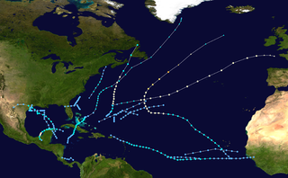
The 2002 Atlantic hurricane season was a near-average Atlantic hurricane season. It officially started on June 1, 2002, and ended on November 30, dates which conventionally limit the period of each year when most tropical cyclones develop in the Atlantic Ocean. The season produced fourteen tropical cyclones, of which twelve developed into named storms; four became hurricanes, and two attained major hurricane status. While the season's first cyclone did not develop until July 14, activity quickly picked up: eight storms developed in the month of September. It ended early however, with no tropical storms forming after October 6—a rare occurrence caused partly by El Niño conditions. The most intense hurricane of the season was Hurricane Isidore with a minimum central pressure of 934 mbar, although Hurricane Lili attained higher winds and peaked at Category 4 whereas Isidore only reached Category 3. However, Lili had a minimum central pressure of 938 mbar.

The 1969 Atlantic hurricane season was the most active Atlantic hurricane season since the 1933 season, and was the final year of the most recent positive ("high-quality") Atlantic multidecadal oscillation (AMO) era. The hurricane season officially began on June 1, and lasted until November 30. The season had the highest number of systems reach hurricane status – twelve – in a single season, until that record was surpassed in 2005. The season was above-average despite an El Niño, which typically suppresses activity in the Atlantic Ocean, while increasing tropical cyclone activity in the Pacific Ocean. Activity began with a tropical depression that caused extensive flooding in Cuba and Jamaica in early June. On July 25, Tropical Storm Anna developed, the first named storm of the season. Later in the season, Tropical Depression Twenty-Nine caused severe local flooding in the Florida Panhandle and southwestern Georgia in September.

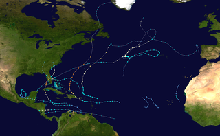
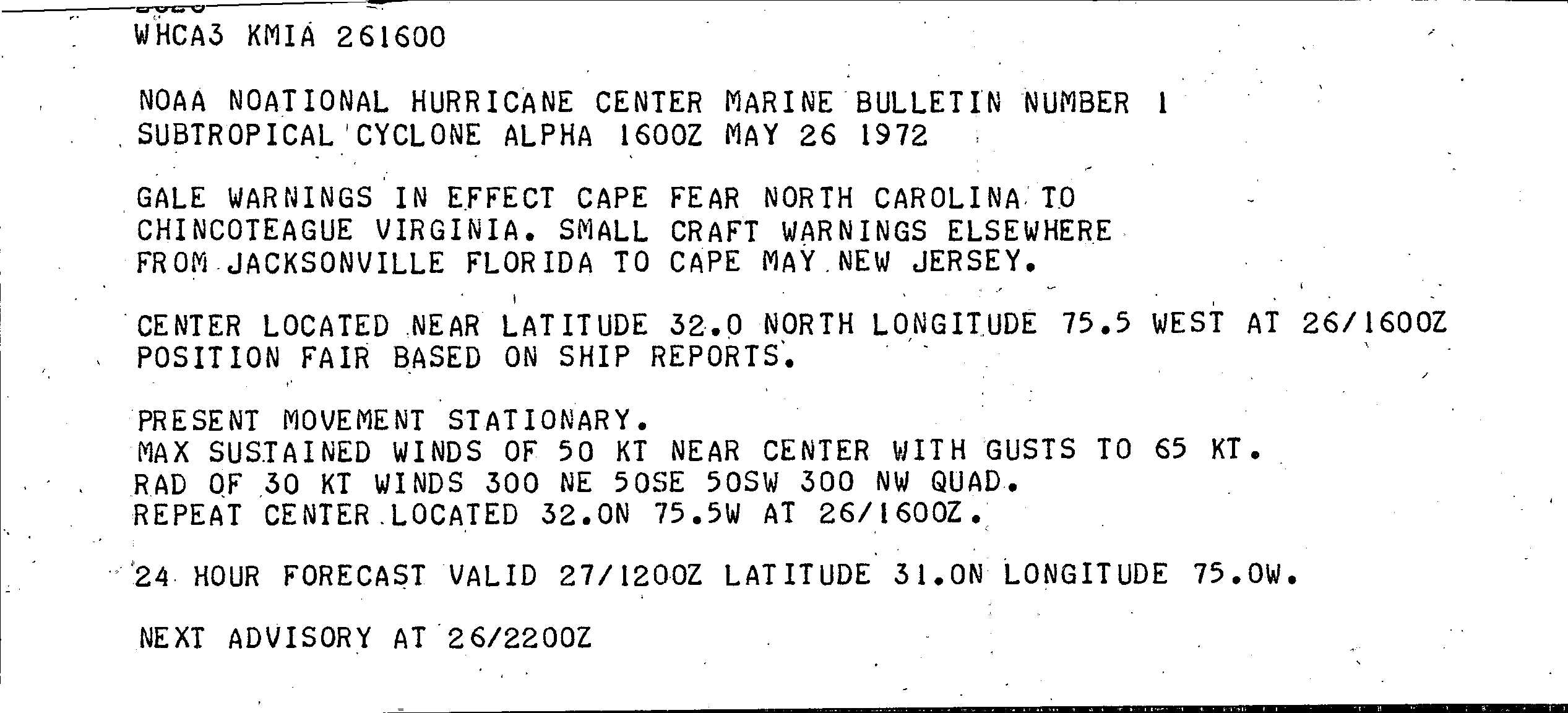
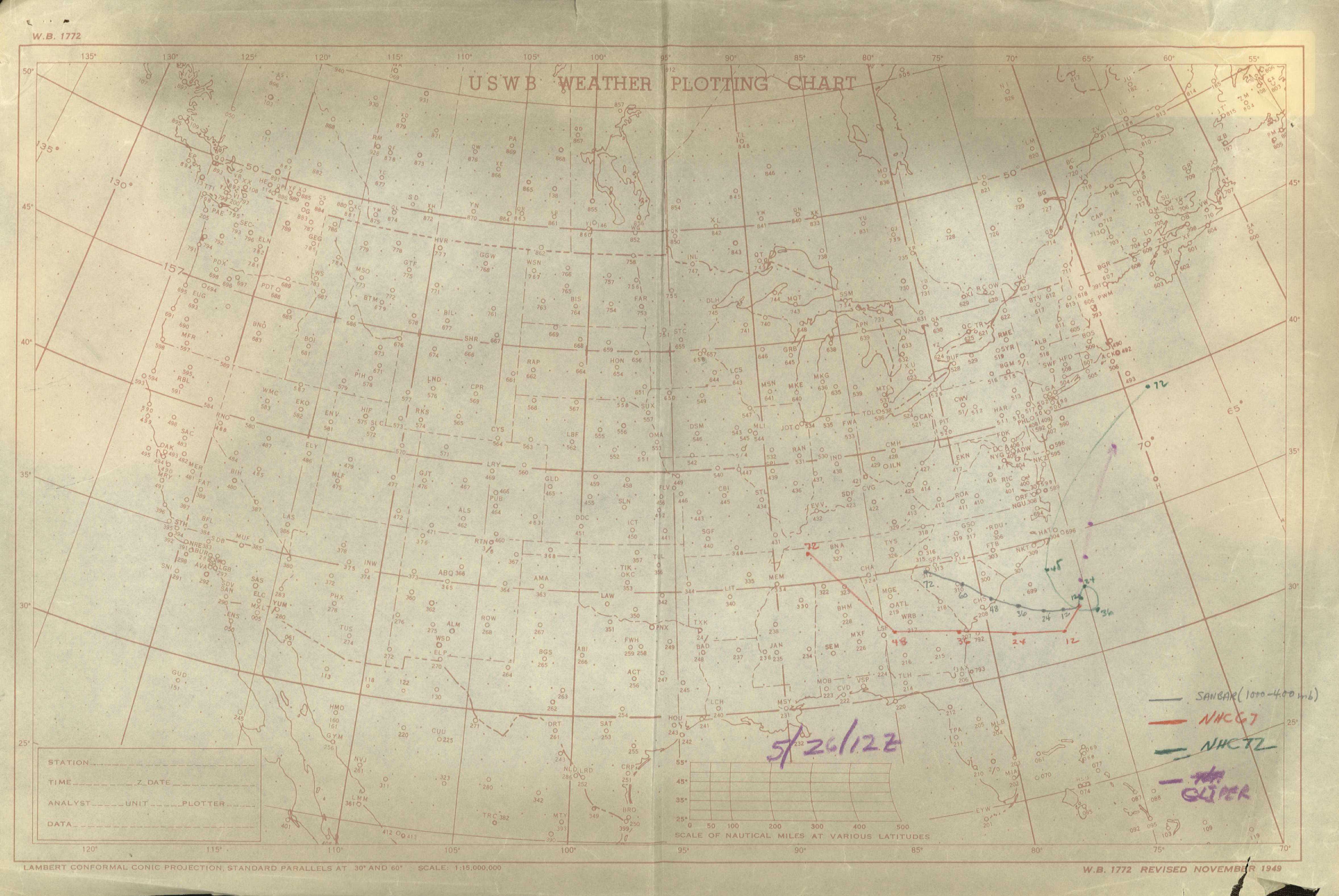
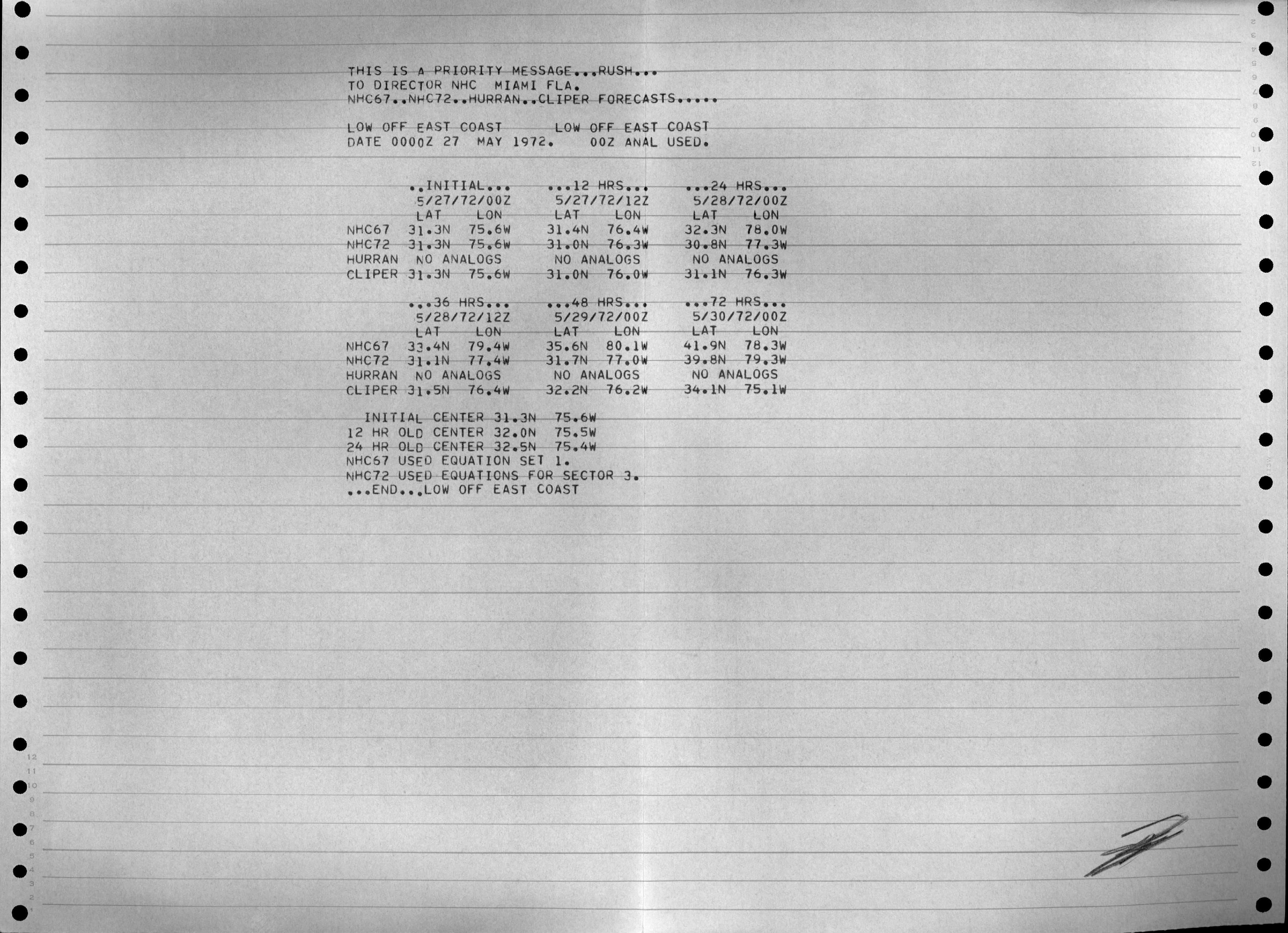
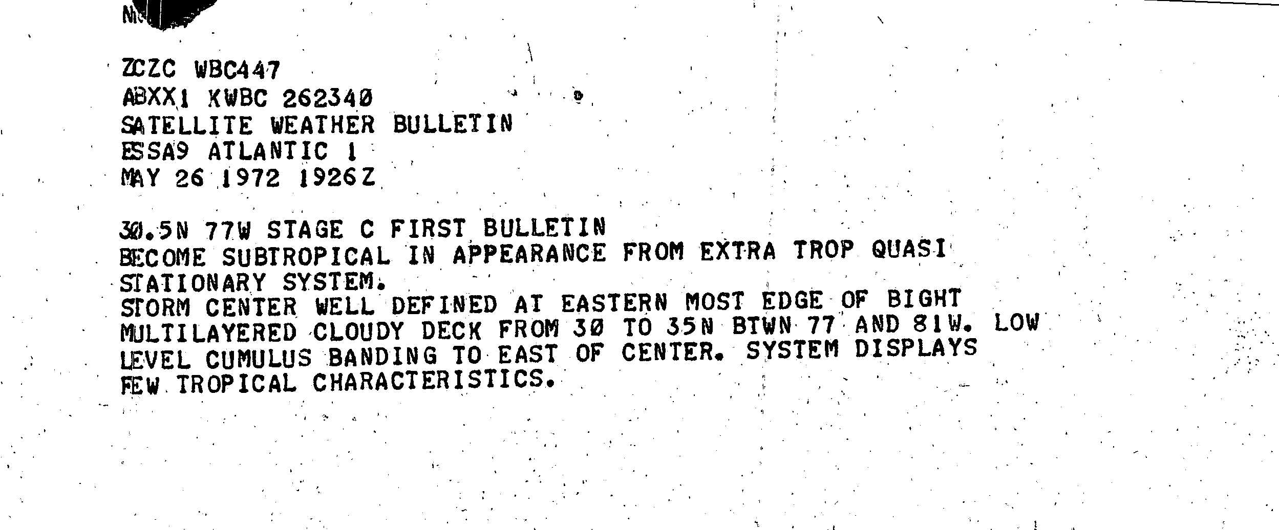
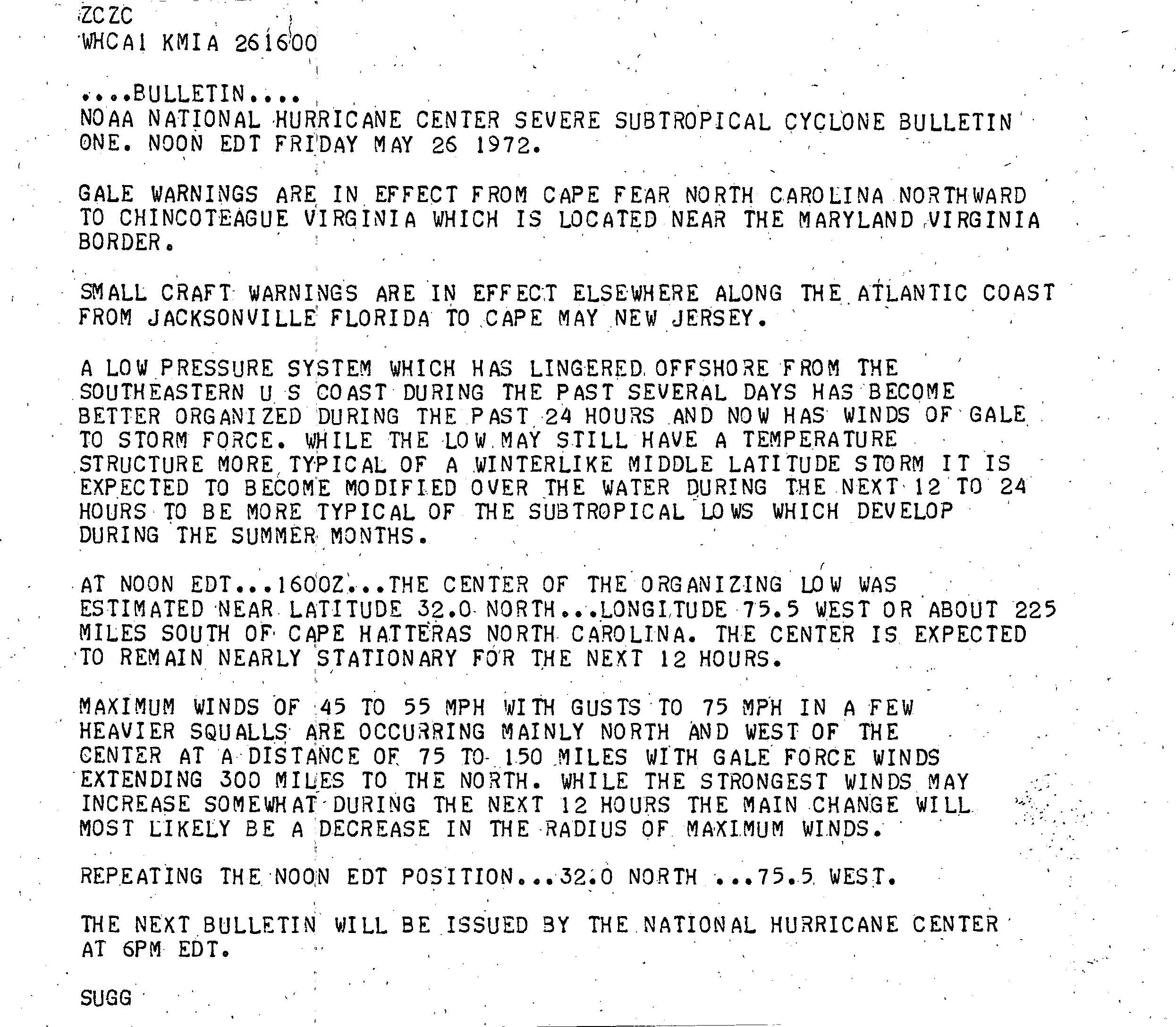
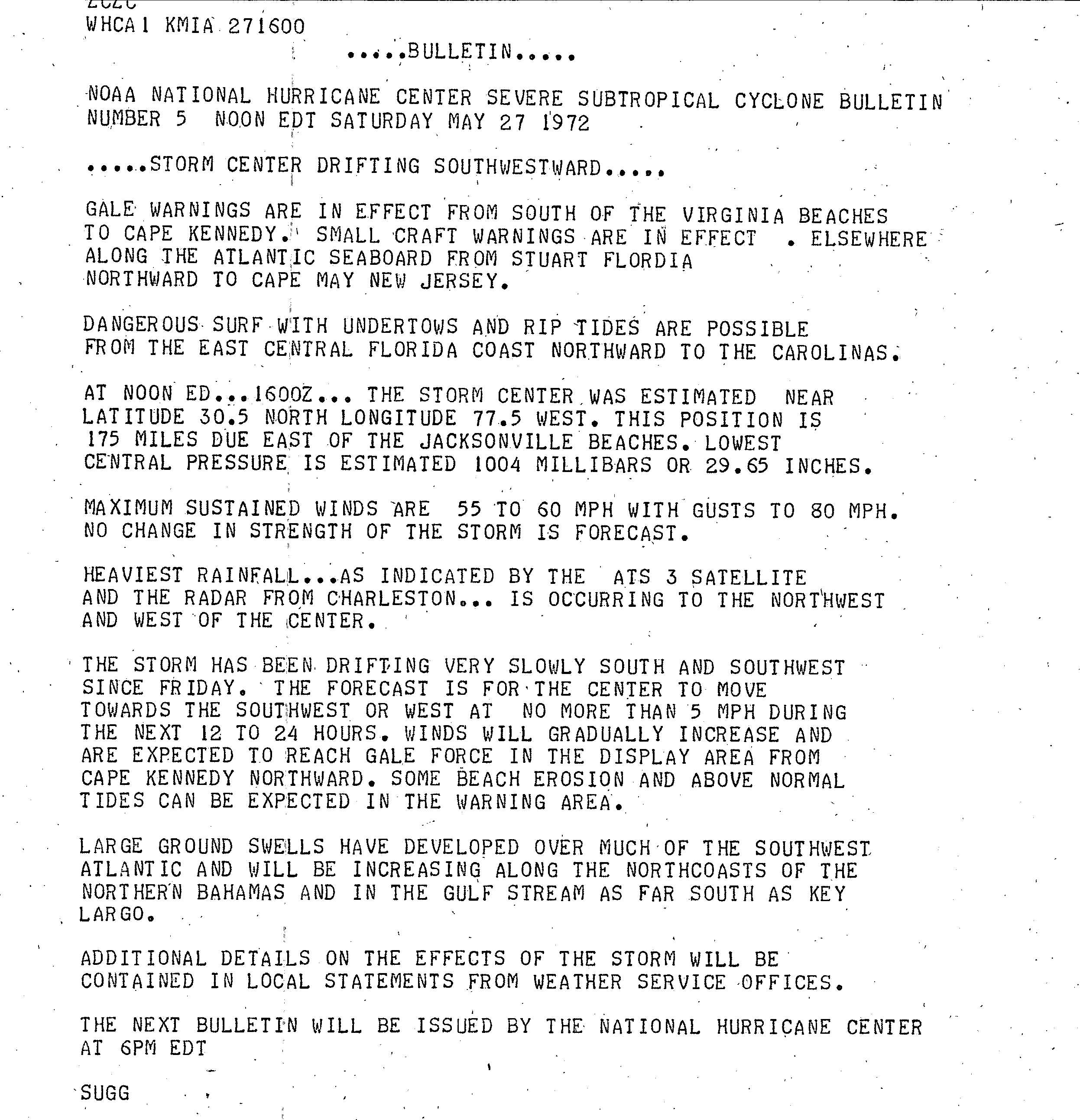
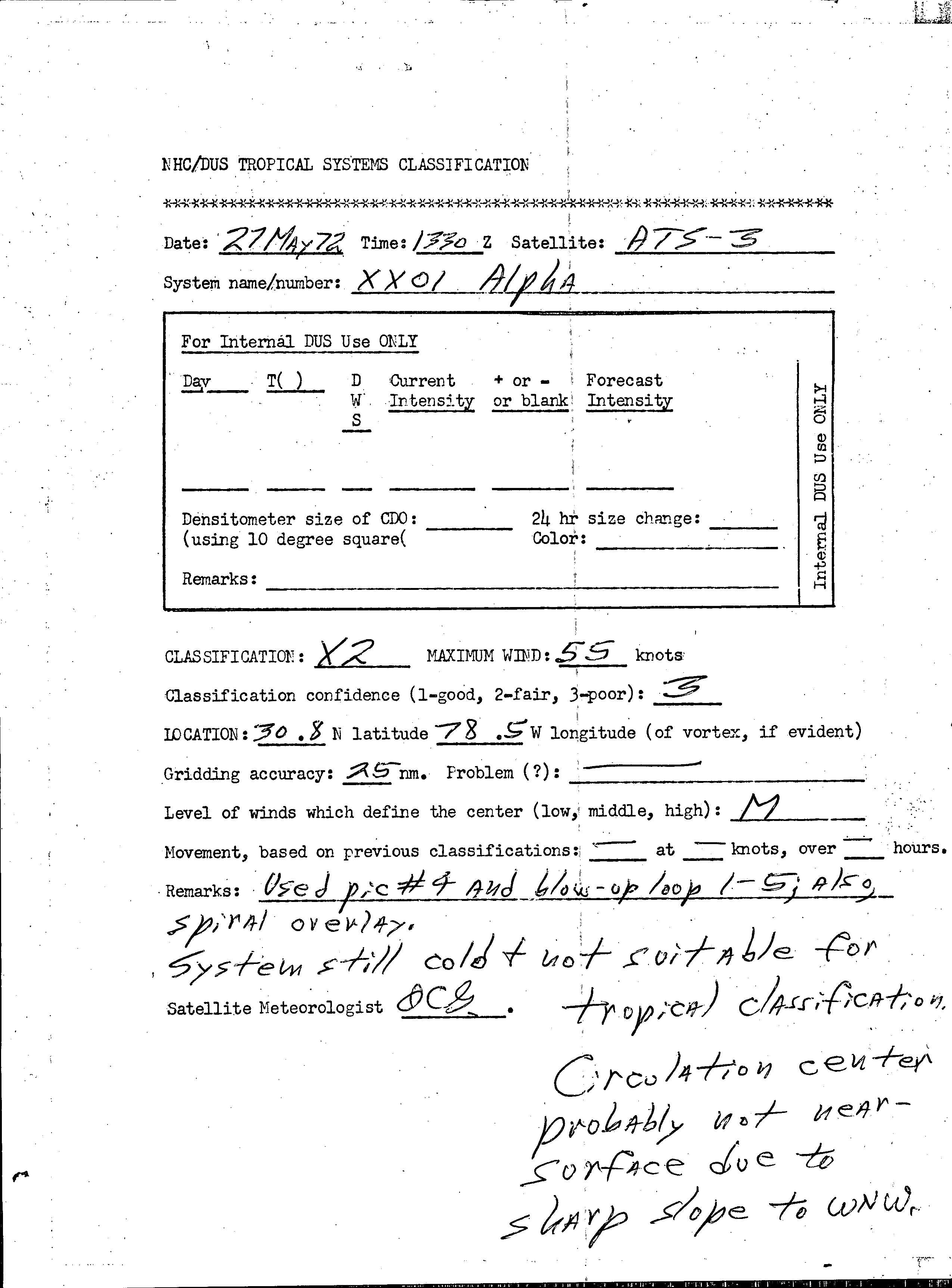
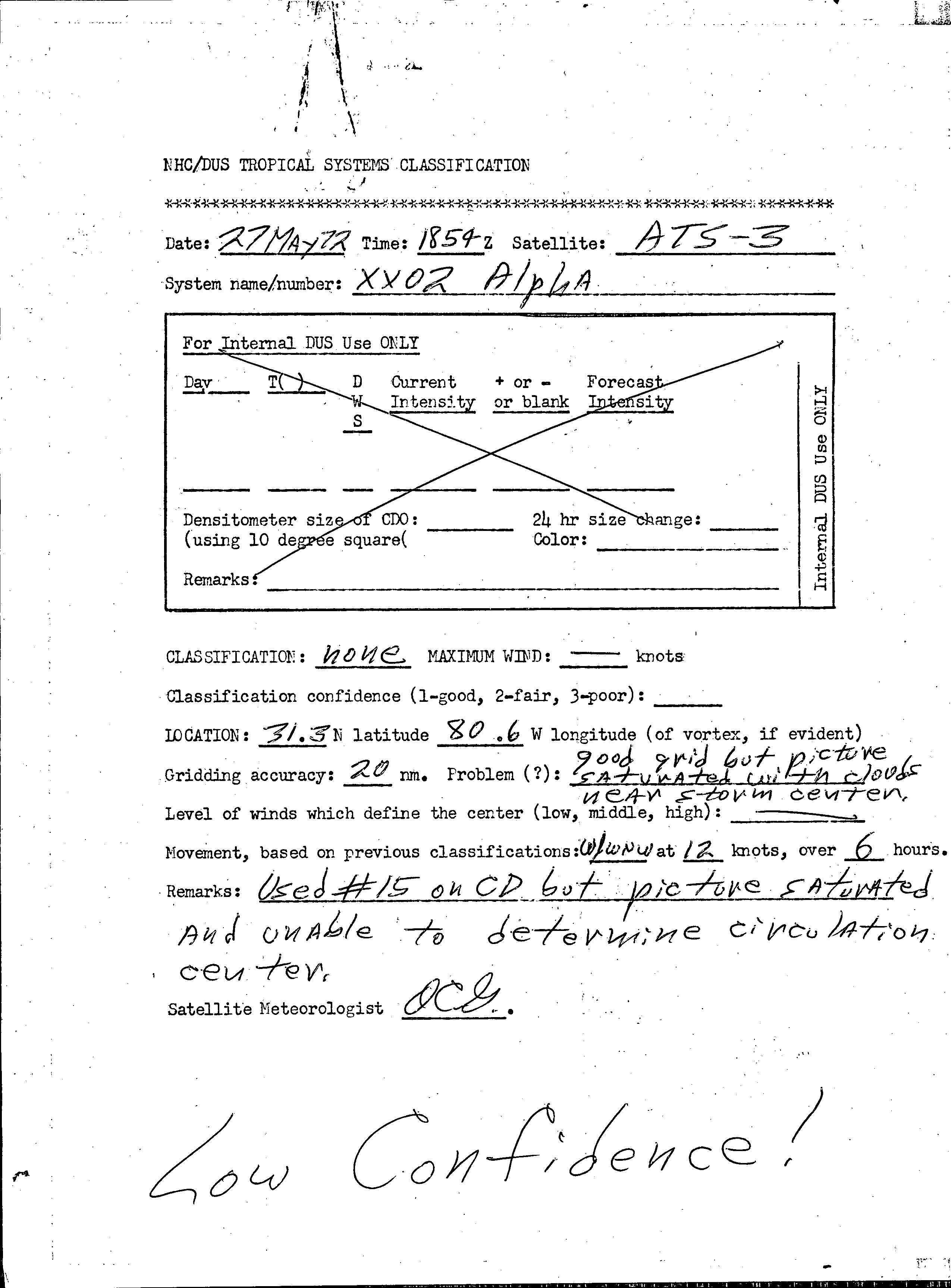
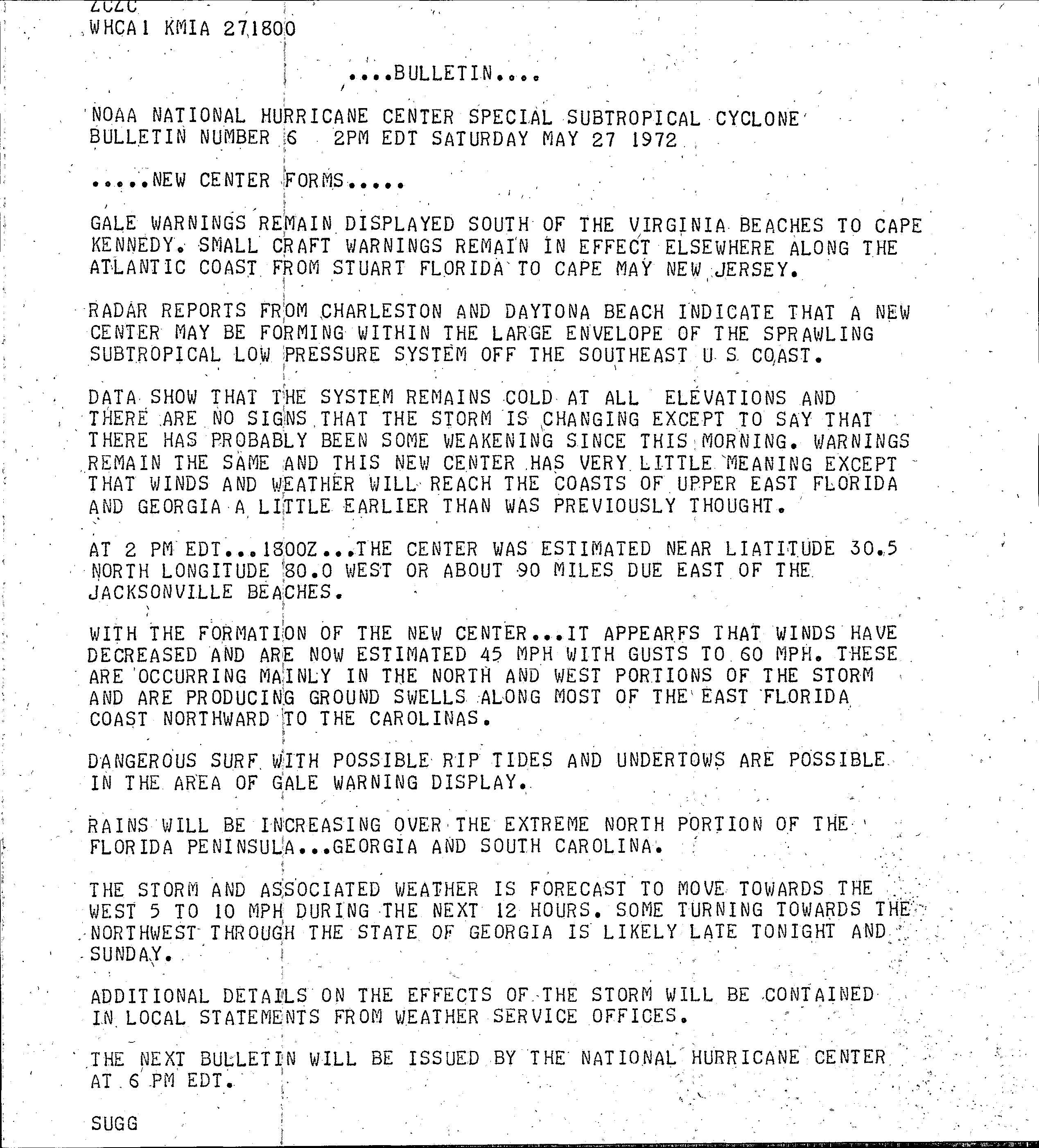
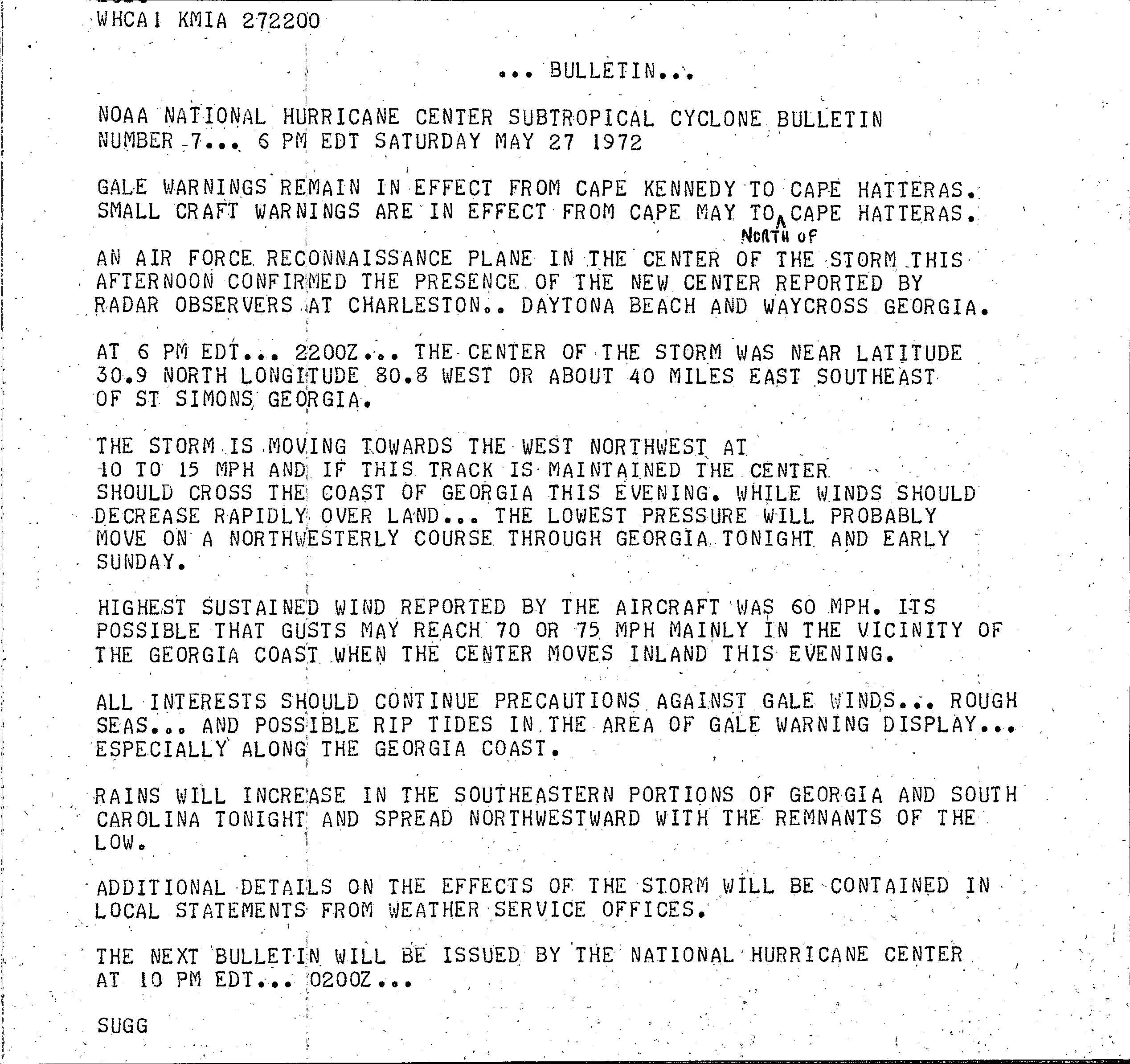
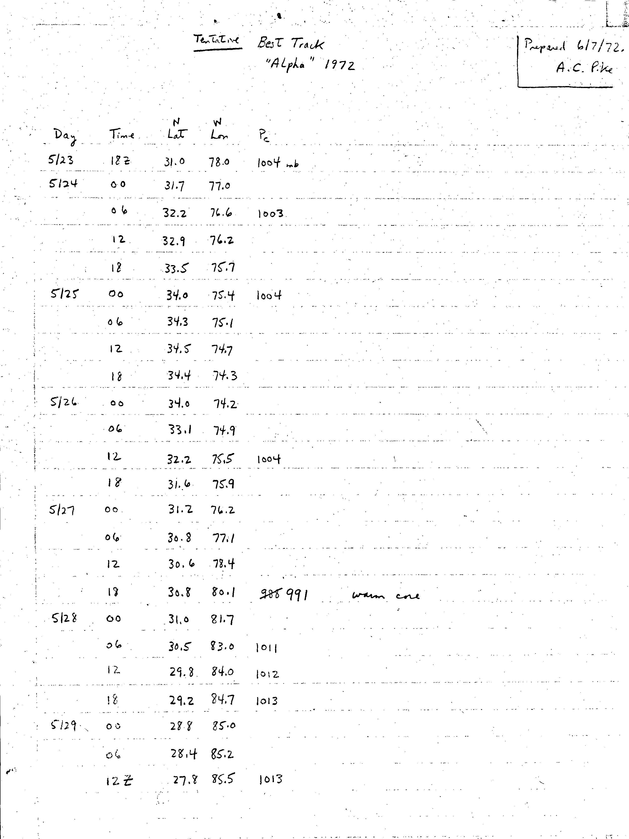
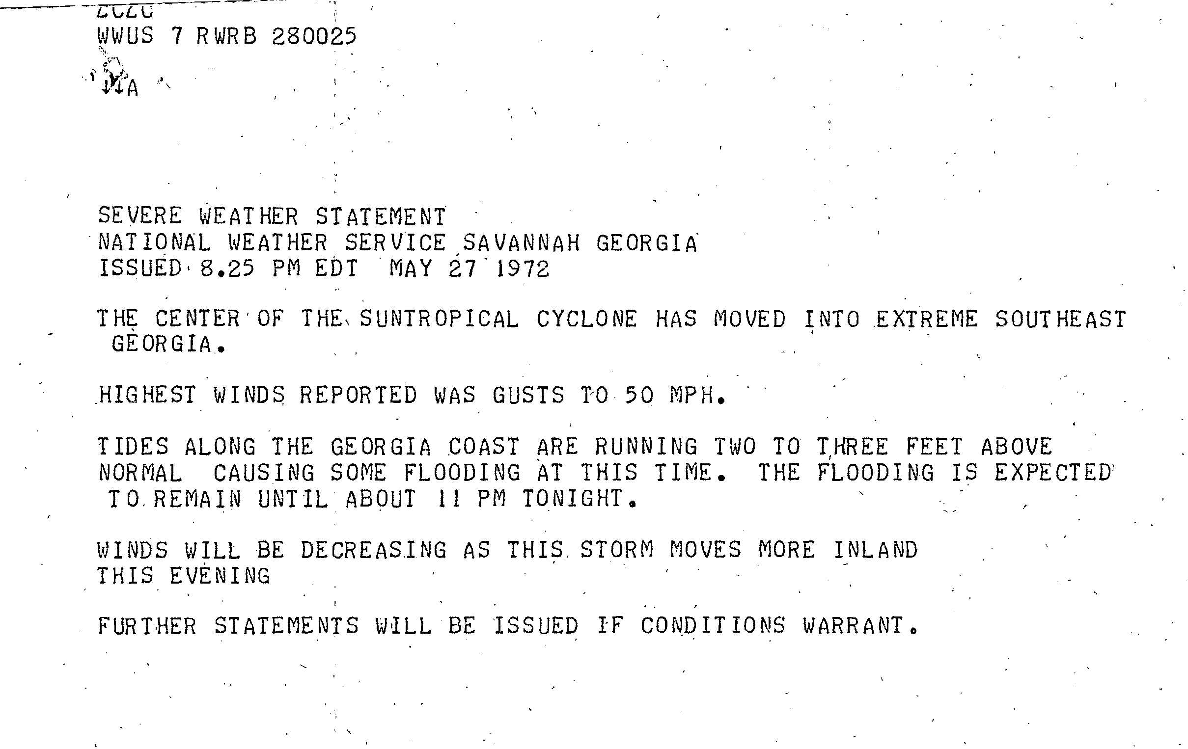
The 1972 Atlantic hurricane season was a significantly below average season, having only seven named storms, four fully tropical storms and three subtropical storms. It officially began on June 1, 1972, and lasted until November 30, 1972. These dates conventionally delimit the period of each year when most tropical cyclones form in the Atlantic basin. The first storm, Subtropical Storm Alpha, developed on May 23 off the Southeast United States and struck Florida, causing minor damage and two fatalities. Although several other tropical depressions developed, only Tropical Depression Five is known to have affected land.
The 1973 Atlantic hurricane season was the first season to use the Saffir–Simpson hurricane scale, a scale developed in 1971 by Herbert Saffir and Robert Simpson to rate the intensity of tropical cyclones. The season produced 24 tropical and subtropical cyclones, of which only 8 reached storm intensity, 4 became hurricanes, and only 1 reached major hurricane status. Although more active than the 1972 season, 1973 brought few storms of note. Nearly half of the season's storms affected land, one of which resulted in severe damage.
The 1978 Atlantic hurricane season was a slightly above average hurricane season in terms of number of named storms. Eleven tropical cyclones were named in all, and five of these became hurricanes; two of the five became a major hurricane. This was also the last Atlantic hurricane season to use an all-female naming list. The season officially began on June 1, 1978, and ended on November 30, 1978. These dates, adopted by convention, denote the period in each year when most tropical cyclogenesis occurs in the Atlantic basin. However, the formation of subtropical or tropical cyclones is possible at any time of the year, as shown by the formation of an unnamed subtropical storm on January 18.

The 1981 Atlantic hurricane season featured direct or indirect impacts from nearly all of its 12 tropical or subtropical storms. Overall, the season was fairly active, with 22 tropical depressions, 12 of which became a namable storm, while 7 of those reached hurricane status and 3 intensified into major hurricanes. The season officially began on June 1, 1981, and lasted until November 30, 1981. These dates conventionally delimit the period of each year when most tropical cyclones form in the Atlantic basin. However, tropical cyclogenesis can occur before these dates, as demonstrated with the development of two tropical depressions in April and Tropical Storm Arlene in May. At least one tropical cyclone formed in each month between April and November, with the final system, Subtropical Storm Three, becoming extratropical on November 17, 1981.

The 2007 Atlantic hurricane season was the first season since 2003 to feature tropical activity both before and after the official bounds of the season. There were an above-average number of named storms during the season – 15, however many storms were weak and short-lived. Despite the predominance of weak systems, this was the first season on record to feature more than one Category 5 landfalling hurricane. This would not happen again until 2017. It produced 17 tropical cyclones, 15 tropical storms, six hurricanes, and two major hurricanes. It officially started on June 1 and ended on November 30, dates which conventionally delimit the period during which most tropical cyclones form in the Atlantic Ocean, although as shown by Subtropical Storm Andrea and Tropical Storm Olga in early May and early December, respectively, the formation of tropical cyclones is possible at any time of the year. The first system, Subtropical Storm Andrea, developed on May 9, while the last storm, Tropical Storm Olga, dissipated on December 13. The most intense hurricane, Dean, was, at the time, the third most intense landfalling Atlantic storm on record. It was the second on record in which an Atlantic hurricane, Felix, and an eastern Pacific hurricane, Henriette, made landfall on the same day. September had a then record-tying eight storms, until it was surpassed in 2020. However, the strengths and durations of most of the storms were low.

The 2008 Atlantic hurricane season was the most destructive Atlantic hurricane season since 2005, causing over 1,000 deaths and nearly $50 billion in damage. The season ranked as the third costliest ever at the time, but has since fallen to ninth costliest. It was an above-average season, featuring sixteen named storms, eight of which became hurricanes, and five which further became major hurricanes. It officially started on June 1 and ended on November 30. These dates conventionally delimit the period of each year when most tropical cyclones form in the Atlantic basin. However, the formation of Tropical Storm Arthur caused the season to start one day early. It was the only year on record in which a major hurricane existed in every month from July through November in the North Atlantic. Bertha became the longest-lived July tropical cyclone on record for the basin, the first of several long-lived systems during 2008.

Hurricane Vince was an unusual hurricane that developed in the northeastern Atlantic basin. Forming in October during the 2005 Atlantic hurricane season, it strengthened over waters thought to be too cold for tropical development. Vince was the twentieth named tropical cyclone and twelfth hurricane of the extremely active season.

Hurricane Kyle was the fifth-longest-lived Atlantic tropical or subtropical cyclone on record. The eleventh named storm and third hurricane of the 2002 Atlantic hurricane season, Kyle developed as a subtropical cyclone on September 20 to the east-southeast of Bermuda. Looping westward, it transitioned into a tropical cyclone and became a hurricane on September 25. For the next two weeks, Kyle tracked generally westward, oscillating in strength several times because of fluctuations in environmental conditions. On October 11, the cyclone turned northeastward and made landfalls near Charleston, South Carolina, and Long Beach, North Carolina, at tropical storm status. After lasting as a cyclone for 22 days, Kyle dissipated on October 12 as it was absorbed by an approaching cold front.
Subtropical Storm Andrea was the first named storm to form in May in the Atlantic Ocean in 26 years. Andrea caused large waves and tropical-storm force winds along the southeast coast of the United States. The first named storm and the first subtropical cyclone of the 2007 Atlantic hurricane season, Andrea developed out of a non-tropical low on May 9 about 150 miles (240 km) northeast of Daytona Beach, Florida, three weeks before the official start of the season. After encountering dry air and strong vertical wind shear, Andrea weakened to a subtropical depression on May 10 while remaining nearly stationary, and the National Hurricane Center discontinued advisories early on May 11. Andrea's remnant was subsequently absorbed into another extratropical storm on May 14. Andrea was the first pre-season storm to develop since Tropical Storm Ana in April 2003. Additionally, the storm was the first Atlantic named storm in May since Tropical Storm Arlene in 1981.

The 1994 Atlantic hurricane season was the final season in the most recent negative Atlantic multidecadal oscillation period of tropical cyclone formation within the basin. Despite the below average activity, the season was very deadly, with almost 97% of deaths occurring during Hurricane Gordon, a devastating late-season tropical cyclone that severely impacted the Caribbean Sea, the Greater Antilles and the United States, and one of the longest-lived Atlantic hurricanes on record at the time. The season produced seven named tropical cyclones and three hurricanes, a total below the seasonal average. The season officially started on June 1 and ended on November 30, dates which conventionally limit the period during which most tropical cyclones form in the Atlantic Ocean. The first tropical cyclone, Tropical Storm Alberto, developed on June 30, while the last storm, Hurricane Gordon, dissipated on November 21. The season was unusual in that it produced no major hurricanes, which are those of Category 3 status or higher on the Saffir–Simpson hurricane scale. The most intense hurricane, Hurricane Florence, peaked as a Category 2 storm with winds of 110 mph (180 km/h). Aside from Chris, Florence, and Gordon, none of the storms exceeded tropical storm intensity.
The 1972 Atlantic hurricane season was a cycle of the annual tropical cyclone season in the Atlantic Ocean in the Northern Hemisphere. It was a significantly below average season, having only four fully tropical named storms, the fewest since 1930. It was one of only five Atlantic hurricane seasons since 1944 to have no major hurricanes, the others being 1968, 1986, 1994, and 2013. The season officially began on June 1, 1972 and ended on November 30, 1972. These dates, adopted by convention, historically describe the period in each year when most tropical systems form. However, storm formation is possible at any time of the year, as demonstrated in 1972 by the formation of Subtropical Storm Alpha on May 23. The season's final storm, Subtropical Storm Delta, dissipated on November 7.

Tropical Storm Beryl was the strongest off-season Atlantic tropical cyclone on record to make landfall in the United States. The second tropical cyclone of the 2012 Atlantic hurricane season, Beryl developed on May 26 from a low-pressure system offshore North Carolina. Initially subtropical, the storm slowly acquired tropical characteristics as it tracked across warmer sea surface temperatures and within an environment of decreasing vertical wind shear. Late on May 27, Beryl transitioned into a tropical cyclone less than 120 miles (190 km) from North Florida. Early the following day, the storm moved ashore near Jacksonville Beach, Florida, with peak winds of 65 mph (100 km/h). It quickly weakened to a tropical depression, dropping heavy rainfall while moving slowly across the southeastern United States. A cold front turned Beryl to the northeast, and the storm became extratropical on May 30.

The 2018 Atlantic hurricane season was the third in a consecutive series of above-average and damaging Atlantic hurricane seasons, featuring 15 named storms, 8 hurricanes, and 2 major hurricanes, which caused a total of over $50 billion in damages and at least 172 deaths. More than 98% of the total damage was caused by two hurricanes. The season officially began on June 1, 2018, and ended on November 30, 2018. These dates historically describe the period in each year when most tropical cyclones form in the Atlantic basin and are adopted by convention. However, subtropical or tropical cyclogenesis is possible at any time of the year, as demonstrated by the formation of Tropical Storm Alberto on May 25, making this the fourth consecutive year in which a storm developed before the official start of the season. The season concluded with Oscar transitioning into an extratropical cyclone on October 31, almost a month before the official end.
The 2019 Atlantic hurricane season was the fourth consecutive above-average and damaging season dating back to 2016. However, many were weak and short-lived, especially towards the end of the season. Six of those named storms achieved hurricane status, while three intensified into major hurricanes. Two storms became Category 5 hurricanes, marking the fourth consecutive season with at least one Category 5 hurricane, the third consecutive season to feature at least one storm making landfall at Category 5 intensity, and the seventh on record to have multiple tropical cyclones reaching Category 5 strength. The season officially began on June 1 and ended on November 30. These dates historically describe the period each year when most tropical cyclones form in the Atlantic basin and are adopted by convention. However, tropical cyclogenesis is possible at any time of the year, as demonstrated by the formation of Subtropical Storm Andrea on May 20, making this the fifth consecutive year in which a tropical or subtropical cyclone developed outside of the official season.

The 2020 Atlantic hurricane season was the most active Atlantic hurricane season on record, in terms of number of systems. It featured a total of 31 tropical or subtropical cyclones, with all but one cyclone becoming a named storm. Of the 30 named storms, 14 developed into hurricanes, and a record-tying seven further intensified into major hurricanes. It was the second and final season to use the Greek letter storm naming system, the first being 2005, the previous record. Of the 30 named storms, 11 of them made landfall in the contiguous United States, breaking the record of nine set in 1916. During the season, 27 tropical storms established a new record for earliest formation date by storm number. This season also featured a record 10 tropical cyclones that underwent rapid intensification, tying it with 1995, as well as tying the record for most Category 4 hurricanes in a singular season in the Atlantic Basin. This unprecedented activity was fueled by a La Niña that developed in the summer months of 2020 as it did, continue a stretch of above-average seasonal activity that began in 2016. Despite the record-high activity, this was the first season since 2015 in which no Category 5 hurricane formed.

The 2023 Atlantic hurricane season is the current hurricane season in the Atlantic Ocean in the Northern Hemisphere. It officially began on June 1, and will end on November 30. These dates, adopted by convention, historically describe the period in each year when most tropical cyclogenesis occurs in the Atlantic. However, the formation of subtropical or tropical cyclones is possible at any time of the year, as shown by the formation of a subtropical storm on January 16, the earliest start of an Atlantic hurricane season since Hurricane Alex in 2016.
The 2022 Atlantic hurricane season was a destructive Atlantic hurricane season, which had an average number of named storms, a slightly above-average number of hurricanes, a slightly below-average number of major hurricanes, and a near-average accumulated cyclone energy (ACE) index. Despite this, it became the third-costliest Atlantic hurricane season on record, behind only 2017 and 2005, mostly due to Hurricane Ian. There were 14 named storms during the season. Eight of them strengthened into hurricanes, and two reached major hurricane intensity. The season officially began on June 1, and ended on November 30. These dates, adopted by convention, historically describe the period in each year when most subtropical or tropical cyclogenesis occurs in the Atlantic Ocean. This year's first Atlantic named storm, Tropical Storm Alex, developed five days after the start of the season, making this the first season since 2014 not to have a pre-season named storm.

Tropical Storm Beta was a tropical cyclone that brought heavy rainfall, flooding, and severe weather to the Southeastern United States in September 2020. The twenty-third tropical depression and twenty-third named storm of the record-breaking 2020 Atlantic hurricane season, Beta originally formed from a trough of low pressure that developed in the northeastern Gulf of Mexico on September 10. The low moved slowly southwestward, with development hampered initially by the development of nearby Hurricane Sally. After Sally moved inland over the Southeastern United States and weakened, the disturbance became nearly stationary in the southwestern Gulf, where it began to organize. By September 16, the storm had gained a low-level circulation center and had enough organization to be designated as Tropical Depression Twenty-Two. The system held its intensity for a day due to the influence of strong wind shear and dry air, before eventually attaining tropical storm strength. It slowly moved northward and intensified to a mid-range tropical storm before dry air and wind shear halted its intensification. Beta then became nearly stationary on September 19, before starting to move west towards the Texas coast the next day, weakening as it approached. On September 21, Beta made landfall near Matagorda Peninsula, Texas as a minimal tropical storm. It subsequently weakened to a tropical depression the next day before becoming post-tropical early on September 23. Its remnants moved northeastward, before the center elongated and merged with a cold front early on September 25.


