Hurricane Beryl

Last updated

Map key
  Tropical depression (≤38 mph, ≤62 km/h)
  Tropical storm (39–73 mph, 63–118 km/h)
  Category 1 (74–95 mph, 119–153 km/h)
  Category 2 (96–110 mph, 154–177 km/h)
  Category 3 (111–129 mph, 178–208 km/h)
  Category 4 (130–156 mph, 209–251 km/h)
  Category 5 (≥157 mph, ≥252 km/h)
  Unknown
Storm type
Disc Plain black.svg Tropical cyclone
Solid black.svg Subtropical cyclone
ArrowUp.svg Extratropical cyclone, remnant low, tropical disturbance, or monsoon depression

The National Hurricane Center (NHC) began monitoring a tropical wave emerging off the coast of West Africa on June 25, producing disorganized showers south of Cabo Verde. [3] By the evening of June 27, the satellite presentation of the disturbance was beginning to show some organization, with curved bands developing around a broad circulation. Environmental conditions at the time were described as being "unusually conducive" for tropical cyclogenesis across the central and western tropical Atlantic for late June, with near record-warm sea surface temperatures (SST) of about 82 °F (28 °C), light wind shear of 6–12 mph (9–19 km/h), plus high mid-level relative humidity of around 70%. [4] [5] The disturbance developed further over the next day, with persistent thunderstorm activity occurring. The center of circulation became well-defined enough for the NHC to designate the system as Tropical Depression Two at 21:00 UTC on June 28, while located about 1,970 km (1,225 mi) east-southeast of Barbados. [6]

Located south of a strong subtropical ridge, the depression moved generally westward through an area of low wind shear, warm sea surface temperatures, and plenty of atmospheric moisture. [5] As a result, it began a period of rapid intensification. The depression strengthened into Tropical Storm Beryl six hours after formation, and the thunderstorms soon organized into a central dense overcast, with a symmetric cloud pattern surrounded by rainbands. [7] [8] Continuing its rapid intensification, Beryl became a hurricane on June 29 as the inner core of the thunderstorms developed into an eye. [9] Observations from the Hurricane Hunters indicated that Beryl became a major hurricane on June 30. [10] Beryl's initial bout of intensification culminated with the storm becoming a Category 4 hurricane, attaining an initial peak intensity with sustained winds of 130 mph (215 km/h). [11] Beryl then underwent an eyewall replacement cycle, weakening slightly going into July 1. [12] The hurricane recovered and quickly restrengthened, and at 15:10 UTC the same day, made landfall in Carriacou, Grenada as a high-end Category 4 hurricane, with sustained winds of 150 mph (240 km/h). [13] [14] Further intensification took place as Beryl entered the Caribbean Sea, with deep convection cooling around the well-defined eye, and Beryl became a Category 5 hurricane early on July 2. [15] The hurricane peaked later that morning with sustained winds of 165 mph (270 km/h) and a central barometric pressure of 934 mb (27.58 inHg). [16] Increasing wind shear due to a tropical upper tropospheric trough eventually caused Beryl to slowly weaken to a Category 4 storm as it passed south of the Dominican Republic. [17] [18]

View of Hurricane Beryl from the International Space Station on July 1 Hurricane Beryl from the ISS.jpg
View of Hurricane Beryl from the International Space Station on July 1

Moving generally west-northwestward under the influence of the strong ridge to its north, Beryl's eye passed very near the southern coast of Jamaica on the afternoon of July 3. Despite the unfavorable conditions, Beryl remained relatively steady as a Category 4 hurricane. [19] Continued weakening eventually resumed, with Beryl falling below major hurricane intensity on July 4, [20] although it briefly regained Category 3 intensity that evening before weakening once more as the pressure again rose quickly. [21] [22] At around 11:05 UTC on July 5, the system made landfall just northeast of Tulum, Quintana Roo, with sustained winds of 110 mph (175 km/h). [23] Inland, Beryl quickly weakened due to land interaction, degrading to a tropical storm. [24] The storm emerged into the Gulf of Mexico the following morning, steered west-northwestward at 13 mph (20 km/h) by the mid-level ridge located over the southeastern U.S. [25] That night and into the next day, in addition to a broader inner core, Beryl was beset by an infusion of dry air and by moderate wind shear which kept the storm from strengthening appreciably. [26] Even so, by the afternoon of July 6, its convective structure had improved some and had become more persistent. [27] Beryl turned to the north-northwest on July 7, and slowed to 10 mph (17 km/h). [28] Beryl re-intensified to hurricane strength near 04:00 UTC on July 8, as its 32 mi-wide (52 km) eye approached the Texas coast. [29] It then made its third and final landfall at 09:00 UTC near Matagorda, Texas with sustained winds of 80 mph (130 km/h). [30] Eight hours later, the system was downgraded to a tropical storm, while centered about 45 mi (70 km) north-northwest of Houston, Texas. [31] Beryl continued to lose strength that afternoon as it moved quickly north-northeastward at 16 mph (26 km/h). [32] And, late that same day, the storm weakened to a tropical depression in the vicinity of Tyler, Texas. [33] The depression moved quickly to the northeast overnight, and Beryl transitioned into an extratropical cyclone on the morning of July 9, about 160 mi (260 km) west-southwest of Paducah, Kentucky. [34] By the following day, the storm's remnants were moving through the Lower Peninsula of Michigan, tracking northeastward into Ontario before dissipating on July 11. [35]

Preparations

Lesser Antilles

Barbados, Grenada, Saint Vincent and the Grenadines, and Saint Lucia were put under a hurricane warning on June 29. [36] Tobago was also put under a hurricane warning on June 30, as was Martinique, along with a vigilance orange. [37] [38] Trinidad was under a tropical storm warning, [39] and Dominica placed under a tropical storm watch. [37] Caribbean Airlines postponed several flights between Barbados, Grenada, Saint Vincent and the Grenadines, and Trinidad and Tobago on June 30. [40] Virgin Atlantic and British Airways also canceled flights in the region as the storm approached. [41]

A state of emergency was declared for Tobago. [42] Ferry schedules were modified on June 30 in Trinidad and Tobago. All ferries to Tobago for July 1 were canceled. [43] Schools across the nation were closed for July 1. [44] As of that morning, the 14 shelters across Tobago sheltered 142 people. [45]

All businesses on Barbados were ordered to be closed by the evening of July 1, and all waterlines were shut down. [46] The India national cricket team was unable to return home from Barbados after winning the 2024 ICC Men's T20 World Cup; [47] scores of fans were also stranded on the island. [48] As Beryl passed nearby, more than 400 people were staying in hurricane shelters across Barbados. [49]

A curfew was instated in Grenada on June 30, and a week-long state of emergency was declared by Governor-General Cécile La Grenade. [50] A Caribbean Community meeting in Grenada, scheduled to run from July 3 to July 5, was canceled. [51] On June 29, Prime Minister Philip J. Pierre of Saint Lucia ordered a national shutdown there. [52] A curfew was also imposed in Saint Vincent and the Grenadines, and the government shut down. [53] [54] In Saint Vincent and the Grenadines, 1,752 people sought refuge from Beryl in shelters, as did over 1,600 people in Grenada. [55]

Sentinel-2 image of the eye of Hurricane Beryl on July 1 Eye of Hurricane Beryl (2024) Sentinel 2.png
Sentinel-2 image of the eye of Hurricane Beryl on July 1

Greater Antilles

The Caribbean coast of the Dominican Republic and Haiti were put under a tropical storm warning on July 2. [56] The advisory was raised on July 3 to a hurricane watch for southwestern Haiti, and an orange alert was put into effect. [57] Additionally, a national cloud cover warning was activated for the Dominican Republic. [58] At least 89 people were in shelters in the in the southwest of the country. [59]

Jamaica's Disaster Risk Coordination Committee convened on July 1 to prepare for the hurricane. [60] The island was placed under a hurricane warning on July 2. [61] Additionally, a state of emergency was imposed as the island was declared a disaster zone as the hurricane approached. Also, a nationwide evacuation order was issued for residents of communities prone to flooding and landslides. [62] Norman Manley International Airport and Sangster International Airport were closed on July 3. [63] A nationwide curfew was implemented by the government on July 3. [64] Over 1,000 people across the nation were in shelters. [55] The Miss Universe Jamaica Grand Coronation, which was scheduled for July 6, was postponed. [65]

The Cayman Islands was put under a hurricane warning on July 2. [61] Owen Roberts International Airport and Charles Kirkconnell International Airport were closed the following day. [63] Just under 4000 persons were evacuated off of the Cayman Islands; several hundred people were evacuated into government Shelters. Cayman Islands Regiment and Cayman Islands Coast Guard fully deployed for humanitarian aid and disaster relief operations. [66]

Norwegian, Carnival, and Disney cruise lines all altered their planned itineraries to avoid the hurricane. [67] Additionally, the various air carriers, including: Cayman Airways, American Airlines, Southwest, Delta, United, Air Canada, adjusted their flight schedules in the region on account of the storm. [63] [68]

Mexico and Belize

On July 1, Quintana Roo was placed on a blue alert in preparation for Beryl. [69] This was upgraded to a red warning three days later. [70] On July 2, the Yucatán state government activated 2,000 shelters. [71] In Quintana Roo, the Mexican Defense Ministry opened 120 shelters. Also, schools throughout the state were closed, [72] as were public beaches. [73] Upward of 25,600 federal troops and national electricity company workers were mobilized throughout the region. [74] Officials prepared 9,000 U.S. gal (34,000 L) of potable water for distribution. [75] They also moved sea turtle eggs off beaches around Cancún in an attempt to protect them from storm surge. [62] About 2,200 people were staying in shelters as the system moved through. [74] The eastern coast of the Yucatán Peninsula was placed under a set of advisories on July 3: a hurricane warning for the coast of the Yucatán Peninsula from Puerto Costa Maya, Quintana Roo, to Cancún; a tropical storm warning south of Puerto Costa Maya to Chetumal, and north of Cancún to Cabo Catoche; and a tropical storm watch west of Cabo Catoche to Campeche, Campeche. [76] More than 300 flights into Cancún International Airport and Tulum International Airport were canceled as Beryl moved in, and Tulum Airport suspended all operations from the afternoon of July 4 through midday July 7. [74] [77] Tren Maya halted operations until July 6. [78] As Beryl moved across the western Gulf of Mexico, a hurricane watch was issued on July 5 for coastal Tamaulipas, from Barra El Mezquital to the mouth of the Rio Grande. [73] [79]

On July 3, a Tropical Storm Watch was issued for the Caribbean coast of Belize, extending from Belize City to Corozal, including the islands of Ambergris Caye and Caye Caulker. Residents in the northern part of Belize were advised to prepare for flooding. [80] The watch was upgraded to a warning on July 4. [81]

United States Gulf Coast

Houston NEXRAD showing Beryl making landfall near Matagorda, Texas on July 8 KHGX loop of Beryl's landfall near Matagorda, Texas 7-8-2024 (2).gif
Houston NEXRAD showing Beryl making landfall near Matagorda, Texas on July 8

In Texas, 121 of the state's counties were placed under a severe weather disaster declaration as Beryl approached. [82] the first hurricane watch and storm surge watch for the Texas coast were put into effect on July 3, extending from the mouth of the Rio Grande northward to Sargent. [79] The coast between Corpus Christi and Sargent was placed under hurricane warning on July 6, with the adjoining areas, including Greater Houston, along with the counties just north of the U.S.–Mexico border, under a tropical storm warning. A storm surge warning is also put into effect from Padre Island to San Luis Pass, including Corpus Christi Bay and Matagorda Bay. [83] Authorities in several coastal counties issued voluntary evacuation orders for residents in low lying and unprotected areas. [84] [85] A mandatory evacuation order was issued in Refugio County by County Judge Jhiela Poynter who cited that she "didn't want to take any chances" following the effects of Hurricane Harvey on the county in 2017. [86] On July 4, Shell and Chevron began moving non-essential employees from oil platforms located off the Texas coast, and preparing them to weather the storm. [87] On July 7, FEMA pre-positioned personnel, commodities, and supplies on the ground in Texas to support state-led hurricane response efforts. [88]

All flights into and out from Houston's William P. Hobby Airport and George Bush Intercontinental Airport were either delayed or canceled for July 6, 1,433 flights in all, were canceled as Beryl approached. [89] Amtrak canceled the July 7 eastbound run and the July 8 westbound of the Sunset Limited between New Orleans, Louisiana, and San Antonio, Texas. [90] Union Pacific and BNSF Railway suspended operations in the Houston area July 7, and Canadian Pacific Kansas City did so for the following day, as Beryl made landfall. [91] Additionally, Amtrak's northbound run of the Texas Eagle , scheduled to depart Longview, Texas, on July 8, for St. Louis, Missouri, [92] with the southbound train being truncated at St. Louis as well. [93]

Impact

Hurricane Beryl
Beryl 2024-07-02 1230Z.jpg
Beryl shortly after peak intensity over the eastern Caribbean Sea on July 2
IBTrACS OOjs UI icon edit-ltr-progressive.svg
Impact by country /territory
Country/TerritoryDeathsDamage (USD)Ref
Barbados 0Un­known
Cayman Islands 0Un­known
Canada 1Un­known [94]
Dominican Republic 0Un­known
Grenada 6$430 million [95] [96]
Haiti 0Un­known
Jamaica 4$41.6 million [97] [98] [99]
Martinique 0Un­known
Mexico 0$90 million [100]
Saint Lucia 0$2 million [101]
Saint Vincent and the Grenadines 8$300 million [102] [103]
Trinidad and Tobago 0Un­known
United States 45 [lower-alpha 1] >$6 billion [97] [104] [105] [106]
Venezuela 6Un­known [97]
Total70>$6.86 billion [107]
  1. 42 deaths in Texas, 1 in Louisiana, and 2 in Vermont
Wind field history of Hurricane Beryl through its entire track Beryl 2024 wind history.png
Wind field history of Hurricane Beryl through its entire track

Lesser Antilles

Beryl moved through the Lesser Antilles as a powerful Category 4 hurricane, battering structures, uprooting trees, and causing near-total power and communication outages across much of the island chain. [108] Hardest hit were Saint Vincent and the Grenadines, and Grenada. The United Nations Office for the Coordination of Humanitarian Affairs (UN OCHA) reported an estimated 200,000 people altogether in the two nations were affected, representing 100% of the population. Also greatly impacted was Barbados, where the Red Cross reported that 208,200 people, about 74% of the population, were affected by the hurricane. [55] It is estimated that insurable losses across region from the hurricane will exceed US$1 billion, according to disaster projections by CoreLogic. [109]

Saint Vincent and the Grenadines

In Saint Vincent and the Grenadines, eight fatalities have been confirmed. [102] At least three of the dead were killed by flying debris, one man was crushed when part of his home collapsed, and another man bled out after being cut on the hand. [97] Also, the MV Guidance II, a 150 ft-long (46 m) ferry with five crew members on board, has been missing from near Canouan Harbor since July 1, when Beryl passed through. [110] The greatest damage was sustained on the islands of Canouan, Mayreau, and Union, where over 90% of homes were damaged or destroyed. [111] [112] Also, the Palm Island Resort, on nearby Palm Island suffered extensive damage. [113] Bequia, [114] and Petit Saint Vincent had considerable damage as well. [115]

Grenada

In Grenada, the island of Carriacou was stripped of all vegetation and its marinas were significantly damaged. There, and on neighboring Petite Martinique, Beryl did significant damage to houses and buildings, and severely disrupted the electrical grid. [112] [116] On the island of Grenada, about 95% of residents were also without power, and telecommunications were down. [117] Additionally, household water storage tanks and cisterns across the islands were either destroyed or compromised by the hurricane; the public water infrastructure also suffered significant damage. [118] There were six fatalities altogether, [95] among them: one person died in St. George's when a tree fell upon their house, while two persons were killed on Carriacou. [97] [119]

In Grenada, the first preliminary damage estimate has been set at $430 million. [96]

Elsewhere

Businesses, homes and roads in Barbados were flooded as Beryl passed nearby; [120] also, roofs, trees and electrical posts were damaged. [48] The most consequential impact occurred along the coast, which was pummeled severely by storm surge. Approximately 90% of the nation's fishing fleet was damaged or destroyed. [121] The Bridgetown Cruise Terminal also suffered damage. [118]

In Tobago and Trinidad, power outages occurred across Tobago, and water service was disrupted. [112] On Trinidad, power outages occurred mainly on the northern and eastern parts of the island. Flooding also occurred on the northern half of Trinidad. [122] In Martinique, Électricité de France stated that 10,000 customers lost power. [123] Flooding in downtown Fort-de-France reached knee-depth. [120] In Saint Lucia, trees and powerlines were downed. Many homes made of weaker materials were damaged and multiple cows were killed. [111] [124] In St. Lucia, the initial assessment of infrastructure and agriculture damage is $2 million. [101]

Beryl's outer bands unleashed strong winds and torrential rains upon northeastern Venezuela, disrupting both air and maritime services. [125] In the state of Sucre, six people were killed, [97] while more than 6,000 houses were damaged. [126] The city of Cumanacoa was flooded by rain dumped by Beryl, which caused the area's Manzanares River to overflow. [127] Hundreds of families fled their homes on account of the flooding and landslides. [125] Several officials, including Vice President Delcy Rodríguez, were injured by a falling tree during a tour of the damage in Cumanacoa. [128] [129]

Greater Antilles

Hurricane Beryl produced gusty winds and rough surf in the Dominican Republic. The hurricane displaced 89 people and cut service to 57 aqueducts. Large waves scattered debris on a section of the Las Américas Highway in Santo Domingo. Storm surge flooding was reported in the neighborhood of Ciudad Nueva, detouring traffic. A landslide destroyed a home in La Zurza. Multiple beachfront shops in Boca Chica were damaged by rough waves. Four dwellings were destroyed by storm surge in La Ciénaga, Barahona, where an additional three houses were damaged. [59] The hurricane caused minimal damage in neighboring Haiti. Roads and agricultural lands along the southern coast were flooded. Fishing boats and other properties were also impacted. [130]

Beryl brushed the southern coast of Jamaica on July 3, with strong winds and rain, causing significant damage to homes, crops and infrastructure. [98] Four people were killed on the island. One woman died when she was struck by a falling tree, another man was killed when he was swept away by floodwaters, and a second man died a day after Beryl passed the island when a wall collapsed on him. Also, the body of an elderly woman was recovered from a pond on July 6. [97] The Jamaican Public Service Company stated that over 400,000 people were without power. [131] [132] The storm’s center passed about 45 mi (72 km) from Kingston, where peak sustained winds of 48 mph (77 km/h) were recorded, with gusts up to 81 mph (130 km/h); rainfall of 10.60 in (269 mm) was recorded on the northeast side the city. [133] A small portion of roof over a passenger boarding pier was damaged at the Norman Manley International Airport in Kingston. [134]

Flash floods and mudslides were reported across the Cayman Islands as Beryl passed. [74] There were no reports of serious damage. [133] The center of the storm passed just 40 mi (64 km) south of Grand Cayman Island. Nearly 6,000 on the island were affected by power outages. [135] Peak sustained winds were measured at 44 mph (71 km/h) at Owen Roberts International Airport, with gusts up to 54 mph (87 km/h). [133]

Mexico

Beryl brought heavy rains and high winds to Cancún and the Riviera Maya resort district along the Caribbean coast of Quintana Roo, resulting in downed trees and power lines, and damage to many roofs; there was also widespread flooding. [74] Many areas lost electricity, including Tulum, Cozumel, and Islas Mujeres municipalities. [136] Tourist infrastructure was without major damage. [73] Beryl's high winds also resulted in fallen trees and power outages in Campeche, including Hopelchén Municipality. [137]

Karen Clark & Company places storm damage losses in Mexico at $90 million. [100]

United States

Wind damage in the United States ranged from $2.5 billion to $3.5 billion, based on an estimate by CoreLogic. [138] A prolific tornado outbreak spawned by Hurricane Beryl happened in eastern Texas, western Louisiana, and Arkansas on July 8. [139] [140] Overall, 113 tornado warnings were issued by the National Weather Service on July 8, the most for a single day in July, surpassing the 67 issued on July 6, 2005, which were related to Hurricane Cindy. [141] The outbreak continued into July 9 with more tornadoes being confirmed, [142] [143] before impacting the interior Northeastern United States and Ontario on July 10. [144] In all, 67 tornadoes were confirmed. [145] [146]

A federal disaster declaration was approved by President Joe Biden on July 2, for parts of Texas hit by the storm. And, Louisiana governor Jeff Landry declared a state of emergency in areas there impacted. [147]

Due to the impact of the storm in Texas, Amtrak canceled the July 10 runs of the Sunset Limited in its entirety in both directions [148] and had the train run only from San Antonio, Texas, to Los Angeles, California and vice versa [149] until the July 17 westbound run.

Texas

Significant flooding caused by Hurricane Beryl in Houston, Texas. Hurricane Beryl--Significant Flooding in Houston.jpg
Significant flooding caused by Hurricane Beryl in Houston, Texas.

Beryl made landfall near Matagorda with the east side of the eyewall impacting Brazoria County. It produced wind gusts over 60–70 mph (97–113 km/h) with a peak gust of 97 mph (156 km/h) in Brazoria. [150] Significant impacts from Beryl took place in Surfside Beach, where siding was completely ripped off from the second story of a house. [151] Multiple A frame homes along the beach were mostly destroyed as a result of Beryl's winds. [152] Numerous other structures suffered extensive damage within the town. [153] In Lake Jackson, Beryl's winds peeled back roofs, knocked down chimneys, and destroyed exterior brick facades. [154]

As Beryl tracked into Texas, Houston was directly impacted by Beryl's eyewall. More than 2.7 million lost power. [155] Over 8 in (200 mm) of rain fell in and around Houston, with a peak rainfall amount for the state being west-southwest of the city at 13.55 in (344 mm). [150]

There were 16 confirmed tornadoes in the state; another tornado tracked out of Louisiana and into Texas. An EF1 tornado caused considerable damage southwest of Jamaica Beach, [156] while an EF2 tornado caused major damage on the west side of Jasper, injuring one person. [157] A high-end EF1 tornado also moved through the town of Timpson, causing roads to become unpassable with one person being trapped. [158] [159] Two EF0 tornadoes and 11 other EF1 tornadoes were also confirmed in the state; [158] the tornado that tracked into Texas out of Louisiana was rated EF1 as well and caused an injury near Bethany, Louisiana and Texas. [158] Two tornadoes were also reportedly spotted in Beaumont, one of which caused some roof damage, although this has not been confirmed yet. [160]

A 53-year-old man was killed in Humble after an oak tree fell into the house with the man and his family inside, crushing the man underneath structural debris. The other occupants of the house were unharmed. A 74-year-old woman was also killed when a tree fell into her room in the Ponderosa Forest neighborhood north of Houston. A woman in her mid-50s was killed when her house caught fire in southeast Houston. [161] A Houston Police Department civilian employee was killed after his car was submerged on Houston Avenue near I-45. [162] Two people drowned in Fort Bend County, and a man was killed by a tree falling on his tractor in New Caney. [163]

Louisiana

In Cameron Parish, Louisiana, portions of LA 27 and LA 82 alongside some roads in Lake Charles saw debris and heavy rainfall due to Beryl. [164] As the storm traveled inland, it had brought severe weather to the northwestern side of the state, with several tornado warnings and power outages; [165] [166] There were 25 confirmed tornadoes in the state, including multiple large and long-tracked tornadoes. Six EF2 tornadoes were also confirmed, [158] with one of them striking Pleasant Hill before causing additional damage north of the town. Unrelated to the tornado to the east of the town, a natural gas leak occurred on LA 174. [167] Another EF2 tornado that injured a person west of Union Springs. [158] Another large, low-end EF2 tornado tracked over 50 mi (80 km) passing through Barksdale Air Force Base, and killing a woman and injuring her two children east of Benton when it knocked a tree down onto her mobile home. [158] [167] An EFU tornado, three EF0 tornadoes, and 15 other EF1 tornadoes were also confirmed in the state, including the aforementioned EF1 tornado that caused an injury and crossed the state line into Texas and two other EF1 tornadoes that crossed into Arkansas. [158] Over 20,000 SWEPCO customers lost power in Northwestern Louisiana. [166]

Mississippi Valley

Arkansas was battered by rain as Beryl moved through as a tropical depression. The highest rainfall total in the state was 8 in (200 mm) in Ico in Grant County. Areas in the Little Rock metropolitan area in Pulaski County received over 2 in (51 mm) of rain with the peak total being 7.31 in (186 mm) in the Ferndale area. [168] Although it had weakened, wind gusts up to tropical storm force were recorded in the state. The peak recorded gust was 47 mph (76 km/h) in Doddridge. [169] [170] Many tornado warnings were issued in the state as well; [171] [172] [173] six EF1 tornadoes and two EF0 tornadoes were confirmed; two other EF1 tornadoes tracked out of Louisiana and into Arkansas. [174] Almost 14,000 Arkansans were without power. [175]

A flood watch was in effect in Missouri for the Mississippi and Missouri Rivers, [176] and other parts of the state, including near the Lake of the Ozarks. The baseball game between St. Louis Cardinals and the Kansas City Royals was rescheduled due to rainfall from Beryl. St. Louis saw flooding and heavy rainfall. [177]

Ohio Valley

Damage to a Kenco facility in Mount Vernon, Indiana caused by EF3 tornado spawned by the remnants of Beryl MountVernon2024EF3AerialSurvey.jpg
Damage to a Kenco facility in Mount Vernon, Indiana caused by EF3 tornado spawned by the remnants of Beryl

Northern Indiana received over 4 in (100 mm) of rain from Beryl. [178] On July 9, the remnants of Hurricane Beryl spawned a long-tracked supercell that produced six tornadoes in western Kentucky and southwestern Indiana. [179] The first two tornadoes touched down in Kentucky, both of which caused EF1 damage. [179] [180] After crossing the Ohio River in Indiana the storm spawned a low-end EF3 tornado that heavily damaged an industrial area and derailed a train on the east side of Mount Vernon, Indiana. This tornado tracked north almost 35 miles through Posey County into Gibson County, where it lifted near Johnson, Indiana [179] [181] The storm later produced two EF1 tornadoes and an EF2 tornado as well. [179] [181] Separate storms also produced EF0 tornadoes near Dubre, Kentucky, and Shoals, Indiana, [182] [183] and an EF1 tornado near Snake Run. Beryl's remnants spawned over nine tornadoes in Southwestern Indiana and Northwestern Kentucky [184] Several tornado watches were issued in addition to flood warnings, watches, and advisories due to heavy rainfall across the Ohio Valley. [185] In Illinois, gusts of up to 40 mph were felt in the central region of the state. The highest gusts were felt at the Coles County Memorial Airport, 45 mph. [186] Flood watches were issued in DuPage County. [187] Many fields, especially in the southern portion of the state, were inundated with floods. About 2–4 in (51–102 mm) of rain fell in the state. [188]

Great Lakes

As the storm's remnants moved over the Lower Peninsula of Michigan late that day and into the next day, 34 counties were put under a flood watch and eight under a flood advisory. [35] Heavy rainfall in Southwest and Central Michigan resulted in localized flash flooding, power outages, and minor storm damage. [189] [190] Highest recorded rainfall totals occurred in Genesee County: 7.06 in (179 mm) at Richfield Center, and 6.79 in (172 mm) in Burton. [191] Elsewhere, the top rainfall report was 5.95 in (151 mm) in Marshall, in Calhoun County. [192]

In Western New York, 25,000 customers lost power; [193] seven tornadoes were also confirmed in the state, including a low-end EF2 tornado that destroyed multiple farm buildings near Eden. [194] [195] Three of the other tornadoes were rated EF1, two were rated EF0, and one was rated EFU. [194] [196] Lowville, New York, recorded 6.02 in (153 mm) of rain, which broke the record for a single day rainfall total. [197]

New England

Towns in northern New Hampshire were severely damaged, while roads were damaged and some bridges. [198] Due to the flooding, around 20 people were left stranded at a Walmart and required rescuing. Monroe, Dalton, and Littleton were among the damaged towns. [199] [200]

Vermont was hit with severe flooding due to Beryl's remnants, wiping away bridges and severely damaging homes. Over 100 people in the state required rescuing due to the storm. Montpelier was the hardest hit area, with over 6 inches (150 mm) of rainfall falling near the city. A man in his UTV was swept off the road and killed in the town of Peacham. [201] [202] Another man died in Lyndonville, while attempting to drive through flood waters. [203] In Plainfield, an apartment building was completely wiped away by floodwaters, and a car was swept away into the water. [204]

Canada

The remnants of Beryl brought torrential rainfall to southern Ontario on July 10, and into the next morning, causing localized flooding. It also put an end to a persistent heat wave, ending a heat warning for the Greater Toronto Area. [205] Additionally, two weak EF0 tornadoes occurred in the London, Ontario, area; damage from tornadoes was limited to crops and trees. [146]

In southwest Quebec, up to 3.9 in (100 mm) of rain was reported in parts of Montreal on July 10. Several highways, including the Decarie Expressway, were temporarily shut down that afternoon as a result of the deluge, which also flooded local streets and basements. Further, over 9,000 Hydro-Québec customers in the Montréal and Montérégie regions were without power. [206] [207]

Beryl's remnant moisture pushed through Nova Scotia on July 11, causing some localized flash flooding and washed out roads. In the Annapolis Valley, over 3.9 in (100 mm) of rain fell within a few hours. Four counties in western Nova Scotia were put under a flash flood alert late that day. Also, in Wolfville, a youth was swept into a ditch, and drowned. [94] [208]

Aftermath

After the hurricane passed the Caribbean, the United Nations authorized $4 million in aid, [209] Grenada and Saint Vincent and the Grenadines getting $1.5 million and Jamaica receiving $2.5 million. [210] The Government of Canada announced it would provide $1.2 million in humanitarian assistance. [211] The United States Agency for International Development announced $4.5 million in humanitarian aid for countries affected by Beryl, including $2.5 million for Jamaica. [212] The European Union authorized $450,000 in humanitarian aid for countries in the Lesser Antilles. [213] The World Food Programme mobilized 5,000 food kits for affected countries in the Caribbean. [214]

The Royal Navy sent a warship with supplies to the Cayman Islands. [215]

Leaders from Antigua and Barbuda, Saint Vincent and the Grenadines, and Grenada signed a letter requesting for debt cancellation and a program to be formed to increase funding after natural disasters. [216] Saint Vincent struggled hosting people from its outer islands that evacuated due to Beryl. [210]

In Barbados, fiberglass fabricator Fiberpol and the Rotary Clubs of Barbados donated a combined $40,000 to help repair the fishing fleet; most of the boats were not insured. [121]

In the wake of Beryl, multiple restaurants in the Houston area sued CenterPoint Energy, amounting to over $100 million, they alleged that CenterPoint's "gross failure in communication and management" caused them to lose customers due to the power being out. [217] [218]

Records

Beryl is the easternmost hurricane to form in the tropical Atlantic in June 49.3°W, beating the mark set by the 1933 Trinidad hurricane  58.9°W. [219] [220] Additionally, it became the earliest Category 4 hurricane on record in the basin, surpassing the previous record set on July 8, 2005, by Hurricane Dennis, [219] [221] and the strongest June hurricane as measured by wind speed, surpassing Hurricane Audrey of 1957. [222] [223] It later became the earliest Category 5 hurricane on record, surpassing the record set on July 16, 2005, by Hurricane Emily, as well as becoming the strongest July hurricane on record by wind speed, [221] [224] [225] and the highest accumulated cyclone energy generating storm before August. [nb 2] [227]

Beryl also became the first tropical system on record to undergo rapid intensification in the Main Development Region of the Atlantic during the month of June. [219] [221] Further, it intensified from tropical storm to Category 5 hurricane in only 42 hours. Only six other Atlantic storms are known to have achieved this rate of intensification, with Beryl the only one to do so earlier than September. [219] [228] According to an analysis by ClimaMeter, a project of the Climate and Environment Sciences Laboratory, Beryl's extreme winds and heavy precipitation were strengthened by climate change. Natural climate variability, notably the Pacific decadal oscillation and the Atlantic multidecadal oscillation, likely played a role as well. [229]

See also

Notes

  1. Hurricanes reaching Category 3 and higher—1-minute sustained winds higher than 110 miles per hour (178 km/h)—on the Saffir–Simpson scale are described as major hurricanes. [1]
  2. A storm's ACE index represents the sum of the squares of the maximum 1-minute sustained wind speed (knots) for that named storm measured every six hours while it is at least tropical storm intensity (≤33 kn (38 mph; 61 km/h)), divided by 10,000. [226]

Related Research Articles

<span class="mw-page-title-main">Hurricane Gilbert</span> Category 5 Atlantic hurricane in 1988

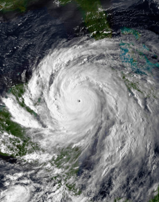
Hurricane Gilbert was the second most intense tropical cyclone on record in the Atlantic basin in terms of barometric pressure, only behind Hurricane Wilma in 2005. An extremely powerful tropical cyclone that formed during the 1988 Atlantic hurricane season, Gilbert peaked as a Category 5 hurricane that brought widespread destruction to the Caribbean and the Gulf of Mexico, and is tied with 1969's Hurricane Camille as the second-most intense tropical cyclone to make landfall in the Atlantic Ocean. Gilbert was also one of the largest tropical cyclones ever observed in the Atlantic basin. At one point, its tropical storm-force winds measured 575 mi (925 km) in diameter. In addition, Gilbert was the most intense tropical cyclone in recorded history to strike Mexico.

<span class="mw-page-title-main">2004 Atlantic hurricane season</span>

The 2004 Atlantic hurricane season was a very deadly, destructive, and active Atlantic hurricane season, with over 3,200 deaths and more than $61 billion in damage. More than half of the 16 tropical cyclones brushed or struck the United States. Due to the development of a Modoki El Niño – a rare type of El Niño in which unfavorable conditions are produced over the eastern Pacific instead of the Atlantic basin due to warmer sea surface temperatures farther west along the equatorial Pacific – activity was above average. The season officially began on June 1 and ended on November 30, though the season's last storm, Otto, dissipated on December 3, extending the season beyond its traditional boundaries. The first storm, Alex, developed offshore of the Southeastern United States on July 31, one of the latest dates on record to see the formation of the first system in an Atlantic hurricane season. It brushed the Carolinas and the Mid-Atlantic, causing one death and $7.5 million (2004 USD) in damage. Several storms caused only minor damage, including tropical storms Bonnie, Earl, Hermine, and Matthew. In addition, hurricanes Danielle, Karl, and Lisa, Tropical Depression Ten, Subtropical Storm Nicole and Tropical Storm Otto had no effect on land while tropical cyclones. The season was the first to exceed 200 units in accumulated cyclone energy (ACE) since 1995, mostly from Hurricane Ivan, the storm produced the highest ACE. Ivan generated the second-highest ACE in the Atlantic, only behind 1899 San Ciriaco Hurricane.

<span class="mw-page-title-main">1998 Atlantic hurricane season</span>

The 1998 Atlantic hurricane season was a catastrophic and deadly Atlantic hurricane season, featuring the highest number of storm-related fatalities in over 218 years and some of the costliest ever at the time. The season had above average activity, due to the dissipation of an El Niño event and transition to La Niña conditions. It officially began on June 1 and ended on November 30, dates which conventionally delimit the period during which most tropical cyclones form in the Atlantic Ocean. The season had a rather slow start, with no tropical cyclones forming in June. The first tropical cyclone, Tropical Storm Alex, developed on July 27, and the season's final storm, Hurricane Nicole, became extratropical on December 1.

<span class="mw-page-title-main">Hurricane Michelle</span> Category 4 Atlantic hurricane in 2001

Hurricane Michelle was the fifth costliest tropical cyclone in Cuban history and the strongest hurricane of the 2001 Atlantic hurricane season. The thirteenth named storm and seventh hurricane that year, Michelle developed from a tropical wave that had traversed into the western Caribbean Sea on October 29; the wave had initially moved off the coast of Africa 13 days prior. In its early developmental stages, the depression meandered over Nicaragua, later paralleling the Mosquito Coast before intensifying into tropical storm intensity on November 1; Michelle was upgraded to hurricane strength the following day. Shortly after, rapid intensification ensued within favorable conditions, with the storm's central barometric pressure dropping 51 mbar in 29 hours. After a slight fluctuation in strength, Michelle reached its peak intensity as a Category 4 hurricane with winds of 140 mph (230 km/h) and a minimum pressure of 933 mbar. This tied Michelle with 1999's Lenny as the fourth most powerful November hurricane on record in the Atlantic Basin, behind only the 1932 Cuba hurricane and 2020 Hurricanes Iota and Eta. At roughly the same time, the hurricane began to accelerate northeastward; this brought the intense hurricane to a Cuban landfall within the Bay of Pigs later that day. Crossing over the island, Michelle was weakened significantly, and was only a Category 1 hurricane upon reentry into the Atlantic Ocean. The hurricane later transitioned into an extratropical cyclone over The Bahamas on November 5, before being absorbed by a cold front the following day.

<span class="mw-page-title-main">1961 Atlantic hurricane season</span>

The 1961 Atlantic hurricane season was a very active Atlantic hurricane season, with an accumulated cyclone energy (ACE) total of 189, the highest since 1950. The season, however, was an average one in terms of named storms. The season featured eight hurricanes and a well above average number of five major hurricanes. It was previously thought that the season had a record-tying seven major hurricanes, before the Atlantic hurricane reanalysis project downgraded two storms in 2019. Two Category 5 hurricanes were seen in 1961, making it one of only seven Atlantic hurricane seasons to feature multiple Category 5 hurricanes in one season. The season started on June 15, and ended on November 15. These dates conventionally delimit the period of each year when most tropical cyclones form in the Atlantic basin. The first system, an operationally unclassified tropical depression, formed offshore east Central Florida on June 10, but dissipated a few days later. Next, Hurricane Anna developed in the eastern Caribbean Sea near the Windward Islands on July 20. It brought minor damage to the islands, as well as wind and flood impacts to Central America after striking Belize as a hurricane. Anna caused one death and about $300,000 (1961 USD) in damage. Activity went dormant for nearly a month and a half, until Hurricane Betsy developed on September 2. Betsy peaked as a Category 4 hurricane, but remained at sea and caused no impact.

<span class="mw-page-title-main">1979 Atlantic hurricane season</span>

The 1979 Atlantic hurricane season was the first Atlantic hurricane season to include both male and female names on its list of tropical cyclone names. The season officially began on June 1, and lasted until November 30. These dates conventionally delimit the period of each year when most tropical cyclones form in the Atlantic basin. It was slightly below average, with nine systems reaching tropical storm intensity. The first system, an unnumbered tropical depression, developed north of Puerto Rico on June 9. Two days later, Tropical Depression One formed and produced severe flooding in Jamaica, with 40 deaths and about $27 million (1979 USD) in damage. Tropical Storm Ana caused minimal impact in the Lesser Antilles. Hurricane Bob spawned tornadoes and produced minor wind damage along the Gulf Coast of the United States, primarily in Louisiana, while the remnants caused flooding, especially in Indiana. Tropical Storm Claudette caused extensive flooding in Texas due to torrential rainfall, resulting in two deaths and about $750 million in damage.

<span class="mw-page-title-main">1981 Atlantic hurricane season</span>

The 1981 Atlantic hurricane season featured direct or indirect impacts from nearly all of its 12 tropical or subtropical storms. Overall, the season was fairly active, with 22 tropical depressions, 12 of which became named storms. 7 of those reached hurricane status and a further 3 intensified into major hurricanes. The season officially began on June 1, 1981, and lasted until November 30, 1981. These dates conventionally delimit the period of each year when most tropical cyclones form in the Atlantic basin. However, tropical cyclogenesis can occur before these dates, as demonstrated with the development of two tropical depressions in April and Tropical Storm Arlene in May. At least one tropical cyclone formed in each month between April and November, with the final system, Subtropical Storm Three, becoming extratropical on November 17, 1981.

<span class="mw-page-title-main">1985 Atlantic hurricane season</span>

The 1985 Atlantic hurricane season had six United States landfalling hurricanes, tied with 1886 and 2020 for the highest number on record. The season officially began on June 1 and lasted until November 30. It was an average season, with 11 named storms developing. This was partially attributed to a La Niña – a meteorological phenomenon that produces favorable conditions across the Atlantic basin, such as lower wind shear and higher sea surface temperatures. The first storm, Ana, developed on July 15 near Bermuda and caused minor effects in Canada while transitioning into an extratropical cyclone. Three other tropical cyclones – Claudette, Henri, and Isabel – did not significantly affect land. Claudette developed offshore of the Southeastern United States and brushed Bermuda and the Azores. Henri and Isabel were dissipating as they approached land. However, the precursor of the latter caused a severe flood in Puerto Rico that killed 180 people. Additionally, Tropical Storm Fabian and three tropical depressions did not have any known impact on land.

<span class="mw-page-title-main">1989 Atlantic hurricane season</span>

The 1989 Atlantic hurricane season was an average hurricane season with 11 named storms. The season officially began on June 1, and ended on November 30. The first tropical cyclone, Tropical Depression One, developed on June 15, and dissipated two days later without any effects on land. Later that month, Tropical Storm Allison caused severe flooding, especially in Texas and Louisiana. Tropical Storm Barry, Tropical Depressions Six, Nine, and Thirteen, and Hurricanes Erin and Felix caused negligible impact. Hurricane Gabrielle and Tropical Storm Iris caused light effects on land, with the former resulting in nine fatalities from rip currents offshore the East Coast of the United States and Atlantic Canada, while the latter produced minor flooding in the United States Virgin Islands.

<span class="mw-page-title-main">Hurricane Beulah</span> Category 5 Atlantic hurricane in 1967

Hurricane Beulah was an intense Category 5 hurricane which impacted the Greater Antilles, Mexico, and Texas in September 1967. The second tropical storm, second hurricane, only major hurricane, and strongest storm in the 1967 Atlantic hurricane season, Beulah tracked through the Caribbean, struck the Yucatán Peninsula of Mexico as a major hurricane, and moved west-northwestward into the Gulf of Mexico, briefly becoming a Category 5 hurricane. The hurricane made landfall just north of the mouth of the Rio Grande as a Category 3 hurricane. It spawned 115 tornadoes across Texas, which established a new record for the highest amount of tornadoes produced by a tropical cyclone. Due to its slow movement over Texas, Beulah led to significant flooding. Throughout its path, at least 59 people were killed and total damage reached $234.6 million, of which $200 million occurred in the United States, $26.9 million occurred in Mexico, and $7.65 million occurred in the eastern Caribbean.

<span class="mw-page-title-main">Hurricane Allen</span> Category 5 Atlantic hurricane in 1980

Hurricane Allen was a rare and extremely powerful Cape Verde hurricane that affected the Caribbean, eastern and northern Mexico, and South Texas in August 1980. The first named storm and second tropical cyclone of the 1980 Atlantic hurricane season, it was the fifth most intense Atlantic hurricane on record in terms of barometric pressure, behind Hurricane Rita, the 1935 Labor Day hurricane, Hurricane Gilbert and Hurricane Wilma. It was one of the few hurricanes to reach Category 5 status on the Saffir–Simpson Hurricane Scale on three occasions, and spent more time as a Category 5 than all but two other Atlantic hurricanes. Allen is the only hurricane in the recorded history of the Atlantic basin to achieve sustained winds of 190 mph, thus making it the strongest Atlantic hurricane by wind speed. Until Hurricane Patricia in 2015, these were also the highest sustained winds in the Western Hemisphere. Hurricane Allen was also the second strongest tropical cyclone to hit the Gulf of Mexico, with the strongest being Hurricane Rita.

<span class="mw-page-title-main">Hurricane Carla</span> Category 4 Atlantic hurricane in 1961

Hurricane Carla was the most intense tropical cyclone landfall in Texas in the 20th century. The third named storm of the 1961 Atlantic hurricane season, Carla developed from an area of squally weather in the southwestern Caribbean Sea on September 3. As a tropical depression, it strengthened while heading northwest. The system was upgraded to a tropical storm on September 5 and reached hurricane intensity on September 6. On September 7, Carla entered the Gulf of Mexico, passing northeast of the Yucatán Peninsula. On the morning of September 11, Carla became a category 4 hurricane when winds reached 130 mph. Carla made landfall at 2 p.m. on September 11 near Port O'Connor, Texas as a category 4 hurricane with a peak intensity of 145 mph. Traveling inland, the storm was reduced to a tropical storm on September 12 and transitioned into an extratropical cyclone on September 13, while centered over southern Oklahoma. Carla's remnants reached the Labrador Sea, Canada and dissipated on September 17, 1961.

<span class="mw-page-title-main">Hurricane Dennis</span> Category 4 Atlantic hurricane in 2005

Hurricane Dennis was briefly the strongest Atlantic hurricane ever to form before August. A deadly and destructive tropical cyclone, Dennis was the fourth named storm of the record-breaking 2005 Atlantic hurricane season. It originated on July 4 near the Windward Islands from a tropical wave. Dennis intensified into a hurricane on July 6 as it moved across the Caribbean Sea. Two days later, it became a strong Category 4 on the Saffir-Simpson scale before striking Cuba twice on July 8. After weakening over land, Dennis re-intensified in the Gulf of Mexico, attaining its lowest barometric pressure of 930 mbar (27 inHg) on July 10. That day, Dennis weakened slightly before making a final landfall on Santa Rosa Island, Florida as a Category 3 hurricane. Six days later, Dennis's record intensity was surpassed by Hurricane Emily. After moving through the central United States, the circulation associated with former Hurricane Dennis dissipated on July 18 over Ontario.

<span class="mw-page-title-main">Hurricane Emily (2005)</span> Category 5 Atlantic hurricane

Hurricane Emily was a powerful early season tropical cyclone that caused significant damage across the Lesser Antilles, the Caribbean, and Mexico. The fifth named storm of the record-breaking 2005 Atlantic hurricane season, Emily is one of only two Category 5 Atlantic hurricanes on record in the month of July, along with Hurricane Beryl in 2024. It formed on July 11 from a tropical wave, which progressed westward across the Atlantic. Three days later, the hurricane struck Grenada before entering the eastern Caribbean Sea. After fluctuating in intensity, Emily strengthened to attain maximum sustained winds of 260 km/h (160 mph) on July 16 while passing southwest of Jamaica. Slight weakening occurred before Emily made landfall along Mexico's Yucatán Peninsula on July 18. Quickly crossing the peninsula, Emily emerged into the Gulf of Mexico and reorganized, making a second landfall in the Mexican state of Tamaulipas on July 20. It rapidly weakened and dissipated over land.

<span class="mw-page-title-main">2008 Atlantic hurricane season</span>

The 2008 Atlantic hurricane season was the most destructive Atlantic hurricane season since 2005, causing over 1,000 deaths and nearly $50 billion in damage. The season ranked as the third costliest ever at the time, but has since fallen to ninth costliest. It was an above-average season, featuring sixteen named storms, eight of which became hurricanes, and five which further became major hurricanes. It officially started on June 1 and ended on November 30. These dates conventionally delimit the period of each year when most tropical cyclones form in the Atlantic basin. However, the formation of Tropical Storm Arthur caused the season to start one day early. It was the only year on record in which a major hurricane existed in every month from July through November in the North Atlantic. Bertha became the longest-lived July tropical cyclone on record for the basin, the first of several long-lived systems during 2008.

<span class="mw-page-title-main">Tropical Storm Beryl (1994)</span> Atlantic tropical storm

Tropical Storm Beryl caused flooding in several states in the Eastern United States in August 1994. The second named storm and third tropical cyclone of the annual hurricane season, Beryl developed from an upper-level low pressure area over the northeastern Gulf of Mexico on August 14. Initially a tropical depression, the system intensified into a tropical storm about 24 hours after forming. Beryl then moved slowly northeastward and peaked with maximum sustained winds of 60 mph (95 km/h) before making landfall near Panama City, Florida, early on August 16. Within 12 hours of moving inland, the storm weakened to a tropical depression, but persisted as a tropical cyclone for a few days while traversing the Eastern United States. Beryl was absorbed by a frontal system while situated over Connecticut early on August 19.

<span class="mw-page-title-main">1994 Atlantic hurricane season</span>

The 1994 Atlantic hurricane season was the final season in the most recent negative Atlantic multidecadal oscillation period of tropical cyclone formation within the basin. The season produced seven named tropical cyclones and three hurricanes, a total well below the seasonal average. The season officially started on June 1 and ended on November 30, dates which conventionally limit the period each year when most tropical cyclones tend to form in the Atlantic Ocean. The first tropical cyclone, Tropical Storm Alberto, developed on June 30, while the last storm, Hurricane Gordon, dissipated on November 21. The season was unusual in that it produced no major hurricanes, which are those of Category 3 status or higher on the Saffir–Simpson hurricane scale. The most intense hurricane, Hurricane Florence, peaked as a Category 2 storm with winds of 110 mph (180 km/h).

<span class="mw-page-title-main">2024 Atlantic hurricane season</span>

The 2024 Atlantic hurricane season is the ongoing Atlantic hurricane season in the Northern Hemisphere. The season officially began on June 1, and will end on November 30. These dates, adopted by convention, historically describe the period in each year when most subtropical or tropical cyclogenesis occurs in the Atlantic Ocean. The first system, Tropical Storm Alberto, developed on June 19, making it the latest first named storm since 2014.

<span class="mw-page-title-main">Hurricane Delta</span> Category 4 Atlantic hurricane in 2020

Hurricane Delta was the record-tying fourth named storm of 2020 to make landfall in Louisiana, as well as the record-breaking tenth named storm to strike the United States in that year. The twenty-sixth tropical cyclone, twenty-fifth named storm, tenth hurricane, and third major hurricane of the record-breaking 2020 Atlantic hurricane season, Delta formed from a tropical wave which was first monitored by the National Hurricane Center (NHC) on October 1. Moving westward, the tropical wave began to quickly organize. A well-defined center of circulation formed with sufficiently organized deep convection on October 4, and was designated as Tropical Depression Twenty-six and soon thereafter, Tropical Storm Delta. Extremely rapid intensification ensued throughout October 5 into October 6, with Delta becoming a Category 4 hurricane within 28 hours of attaining tropical storm status. The rate of intensification was the fastest in the Atlantic basin since Hurricane Wilma in 2005. After peaking in intensity however, an unexpected increase in wind shear and dry air quickly weakened the small storm before it made landfall in Puerto Morelos, Mexico as a Category 2 hurricane with 105 mph (169 km/h) winds. It weakened some more over land before emerging into the Gulf of Mexico, where it was downgraded to a Category 1 hurricane. After that, it began to restrengthen, regaining Category 3 status late on October 8. It then turned northward and reached a secondary peak intensity of 953 mbar (28.14 inHg) and winds of 120 mph early on October 9. Delta then began to turn more north-northeastward into an area of cooler waters, higher wind shear, and dry air, causing it to weaken back to Category 2 status. Delta then made landfall at 23:00 UTC near Creole, Louisiana with winds of 100 mph (160 km/h) and a pressure of 970 mbar (29 inHg). The storm began to weaken more rapidly after landfall, becoming post-tropical just 22 hours later.

References

  1. "Saffir-Simpson Hurricane Wind Scale". Miami, Florida: National Hurricane Center. Archived from the original on June 20, 2020. Retrieved November 29, 2023.
  2. Grunau, Sarah (July 30, 2024). "Houston area Hurricane Beryl death toll spikes to 36, at least one other death pending". Houston Public Media. Retrieved August 9, 2024.
  3. Bucci, Lisa (June 25, 2024). Tropical Weather Outlook (Report). Miami, Florida: National Hurricane Center. Archived from the original on June 26, 2024. Retrieved June 26, 2024.
  4. Kelly, Larry (June 27, 2024). Tropical Weather Outlook (Report). Miami, Florida: National Hurricane Center. Archived from the original on July 8, 2024. Retrieved July 8, 2024.
  5. 1 2 Masters, Jeff; Henson, Bob (June 27, 2024). "An early start to the Atlantic's Cabo Verde season?". New Haven, Connecticut: Yale Climate Connections. Archived from the original on June 27, 2024. Retrieved June 27, 2024.
  6. Cangialosi, John (June 28, 2024). Tropical Depression Two Discussion Number 1 (Report). Miami, Florida: National Hurricane Center. Archived from the original on June 28, 2024. Retrieved June 28, 2024.
  7. Cangialosi, John (June 28, 2024). Tropical Storm Beryl Discussion Number 2 (Report). Miami, Florida: National Hurricane Center. Archived from the original on June 30, 2024. Retrieved June 28, 2024.
  8. Cangialosi, John (June 28, 2024). Tropical Storm Beryl Discussion Number 4 (Report). Miami, Florida: National Hurricane Center. Archived from the original on June 30, 2024. Retrieved June 30, 2024.
  9. Papin, Philippe (June 29, 2024). Hurricane Beryl Discussion Number 6 (Report). Miami, Florida: National Hurricane Center. Archived from the original on June 30, 2024. Retrieved June 29, 2024.
  10. Cangialosi, John (June 30, 2024). Hurricane Beryl Intermediate Advisory Number 7A (Report). Miami, Florida: National Hurricane Center. Archived from the original on June 30, 2024. Retrieved June 30, 2024.
  11. Cangialosi, John (June 30, 2024). Hurricane Beryl Tropical Cyclone Update (Report). Miami, Florida: National Hurricane Center. Archived from the original on June 30, 2024. Retrieved June 30, 2024.
  12. Blake, Eric. Hurricane Beryl Intermediate Advisory Number 10A (Report). Miami, Florida: National Hurricane Center. Archived from the original on July 1, 2024. Retrieved July 1, 2024.
  13. Reinhart, Brad. Hurricane Beryl Intermediate Advisory Number 11A (Report). Miami, Florida: National Hurricane Center. Archived from the original on July 1, 2024. Retrieved July 1, 2024.
  14. Reinhart, Brad; Kelly, Larry; Cangialosi, John. Hurricane Beryl Tropical Cyclone Update (Report). Miami, Florida: National Hurricane Center. Archived from the original on July 1, 2024. Retrieved July 1, 2024.
  15. Papin, Philippe (July 1, 2024). Hurricane Beryl Discussion 14 (Report). Miami, Florida: National Hurricane Center. Archived from the original on July 2, 2024. Retrieved July 2, 2024.
  16. Bucci, Lisa; Blake, Eric (July 2, 2024). Hurricane Beryl Discussion 15 (Report). Miami, Florida: National Hurricane Center. Archived from the original on July 2, 2024. Retrieved July 2, 2024.
  17. Beven, John (July 2, 2024). Hurricane Beryl Intermediate Advisory Number 16A (Report). Miami, Florida: National Hurricane Center. Archived from the original on July 3, 2024. Retrieved July 2, 2024.
  18. Beven, John (July 2, 2024). Hurricane Beryl Discussion 17 (Report). Miami, Florida: National Hurricane Center. Archived from the original on July 4, 2024. Retrieved July 3, 2024.
  19. Beven, John (July 3, 2024). Hurricane Beryl Discussion 21 (Report). Miami, Florida: National Hurricane Center. Archived from the original on July 4, 2024. Retrieved July 4, 2024.
  20. Beven, John (July 4, 2024). Hurricane Beryl Intermediate Advisory Number 24A (Report). Miami, Florida: National Hurricane Center. Archived from the original on July 6, 2024. Retrieved July 4, 2024.
  21. Cangialosi, John (July 4, 2024). Hurricane Beryl Discussion 26 (Report). Miami, Florida: National Hurricane Center. Archived from the original on July 5, 2024. Retrieved July 4, 2024.
  22. Papin, Philippe (July 5, 2024). Hurricane Beryl Discussion 27 (Report). Miami, Florida: National Hurricane Center. Archived from the original on July 5, 2024. Retrieved July 5, 2024.
  23. Beven, John (July 5, 2024). Hurricane Beryl Tropical Cyclone Update (Report). Miami, Florida: National Hurricane Center. Archived from the original on July 5, 2024. Retrieved July 5, 2024.
  24. Beven, John (July 5, 2024). Tropical Storm Beryl Intermediate Advisory Number 28A (Report). Miami Florida: National Hurricane Center. Archived from the original on July 5, 2024. Retrieved July 5, 2024.
  25. Cangialosi, John (July 5, 2024). Tropical Storm Beryl Discussion 30 (Report). Miami, Florida: National Hurricane Center. Archived from the original on July 8, 2024. Retrieved July 5, 2024.
  26. Masters, Jeff; Henson, Bob (July 6, 2024). "Beryl slowly reorganizing over the Gulf of Mexico". New Haven, Connecticut: Yale Climate Connections. Archived from the original on July 6, 2024. Retrieved June 27, 2024.
  27. Beven, John (July 6, 2024). Tropical Storm Beryl Discussion 33 (Report). Miami, Florida: National Hurricane Center. Archived from the original on July 8, 2024. Retrieved July 6, 2024.
  28. Rinehart, Brad (July 7, 2024). Hurricane Beryl Discussion Number 38 (Report). Miami, Florida: National Hurricane Center. Archived from the original on July 8, 2024. Retrieved July 8, 2024.
  29. Beven, John (July 8, 2024). Hurricane Beryl Discussion Number 39 (Report). Miami, Florida: National Hurricane Center. Archived from the original on July 8, 2024. Retrieved July 8, 2024.
  30. Beven, John (July 8, 2024). Hurricane Beryl Advisory Number 39 (Report). Miami, Florida: National Hurricane Center. Archived from the original on July 8, 2024. Retrieved July 8, 2024.
  31. Masters, Jeff; Henson, Bob (July 8, 2024). "Houston area slammed by Beryl's winds and water". New Haven, Connecticut: Yale Climate Connections. Archived from the original on July 8, 2024. Retrieved July 8, 2024.
  32. Blake, Eric (July 8, 2024). Tropical Storm Beryl Discussion Number 41 (Report). Miami, Florida: National Hurricane Center. Archived from the original on July 9, 2024. Retrieved July 8, 2024.
  33. Cangialosi, John (July 8, 2024). Tropical Depression Beryl Intermediate Advisory Number 41A (Report). Miami, Florida: National Hurricane Center. Archived from the original on July 9, 2024. Retrieved July 8, 2024.
  34. Taylor, Zack; Roth, David (July 9, 2024). Post-Tropical Cyclone Beryl Advisory Number 44 (Report). College Park, Maryland: Weather Prediction Center. Retrieved July 9, 2024.
  35. 1 2 Hutchinson, Derick (July 10, 2024). "Beryl weather effect in Michigan: 34 counties under flood watch, 8 under flood advisory". Detroit, Michigan: WDIV-TV. Archived from the original on July 10, 2024. Retrieved July 10, 2024.
  36. Papin, Philippe (June 29, 2024). Hurricane Beryl Intermediate Advisory Number 5A (Report). Miami, Florida: National Hurricane Center. Archived from the original on June 30, 2024. Retrieved June 29, 2024.
  37. 1 2 Faheid, Dalia; Tonks, Sara (June 30, 2024). "Hurricane Beryl is expected to intensify into a dangerous major storm as it approaches the Caribbean". CNN. Archived from the original on June 30, 2024. Retrieved June 30, 2024.
  38. "Ouragan Beryl : la Martinique reste en vigilance orange pour vagues-submersion et jaune pour fortes pluies et orages et vents violents" [Hurricane Beryl: Martinique remains on orange alert for waves-submersion and yellow for heavy rain and storms and violent winds]. franceinfo.fr (in French). July 1, 2024. Archived from the original on July 1, 2024. Retrieved July 1, 2024.
  39. Coto, Dánica (June 30, 2024). "Hurricane Beryl approaches the southeast Caribbean after strengthening into a Category 4 storm". Rochester, New York: WHEC-TV. Associated Press. Archived from the original on July 1, 2024. Retrieved June 30, 2024.
  40. "CAL announces flight cancellations due to severe weather". Loop Caribbean News. June 30, 2024. Archived from the original on July 2, 2024. Retrieved June 30, 2024.
  41. Calder, Simon (July 1, 2024). "Hurricane Beryl: Flight cancellations as storm heads to the Caribbean". The Independent. Archived from the original on July 2, 2024. Retrieved July 2, 2024.
  42. "L'ouragan Béryl, rétrogradé en catégorie 3, avance vers les Caraïbes" [Hurricane Beryl, downgraded to category 3, advances towards the Caribbean]. Franceinfo (in French). July 1, 2024. Archived from the original on July 1, 2024. Retrieved July 1, 2024.
  43. "All ferry sailings for Monday cancelled". Trinidad & Tobago Guardian. June 30, 2024. Archived from the original on June 30, 2024. Retrieved June 30, 2024.
  44. Burnie, Gregory MC (June 30, 2024). "Hurricane Beryl closes schools in Trinidad and Tobago". Trinidad and Tobago Newsday. Archived from the original on July 1, 2024. Retrieved July 1, 2024.
  45. Connelly, Corey (July 1, 2024). "142 people at 14 shelters in Tobago". Trinidad and Tobago Newsday. Archived from the original on July 1, 2024. Retrieved July 1, 2024.
  46. Aggarwal, Mithil (July 1, 2024). "Hurricane Beryl closes in on Caribbean as dangerous Category 4 storm". NBC News. Archived from the original on July 1, 2024. Retrieved July 1, 2024.
  47. "Hurricane Beryl disrupts T20 WC winning Indian team's return from Barbados". Business Standard. Bridgetown, Barbados. June 30, 2024. Archived from the original on June 30, 2024. Retrieved June 30, 2024.
  48. 1 2 Coto, Dánica (July 1, 2024). "Beryl makes landfall as Category 4 hurricane on island near Grenada". Las Vegas, Nevada: KLAS-TV. Associated Press. Archived from the original on July 1, 2024. Retrieved July 1, 2024.
  49. Wolfe, Elizabeth (July 1, 2024). "Hurricane Beryl nears Caribbean as life-threatening Category 3 storm – marking an unusually early start to hurricane season". CNN. Archived from the original on July 1, 2024. Retrieved July 1, 2024.
  50. De Shong, Dillon (June 30, 2024). "Hurricane Beryl: Grenada to go on lockdown from 7pm". Loop News. Archived from the original on July 2, 2024. Retrieved June 30, 2024.
  51. Neal, David J.; Charles, Jacqueline (June 30, 2024). "The Caribbean begins to shut down in preparation for Category 4 Hurricane Beryl". Miami Herald . Archived from the original on July 2, 2024. Retrieved June 30, 2024.
  52. "PM Announces National Shutdown From 8:30 PM On Sunday". St. Lucia Times. June 29, 2024. Archived from the original on July 1, 2024. Retrieved June 29, 2024.
  53. De Shong, Dillon (June 30, 2024). "St Vincent PM expects Hurricane Beryl to severely damage the country". Loop News. Archived from the original on July 2, 2024. Retrieved June 30, 2024.
  54. "Hurricane Beryl: St Vincent govt orders national shutdown for 7pm". St Vincent Times. June 30, 2024. Archived from the original on July 1, 2024. Retrieved July 1, 2024.
  55. 1 2 3 "Saint Vincent and the Grenadines, Grenada, Barbados and Jamaica | Hurricane Beryl – Emergency Appeal No. MDRS2001". United Nations Office for the Coordination of Humanitarian Affairs. July 6, 2024. Archived from the original on July 6, 2024. Retrieved July 20, 2024 via Reliefweb.
  56. Tribou, Richard (July 2, 2024). "Hurricane Beryl grows to Category 5 with Jamaica next in sights". Orlando Sentinel. Archived from the original on July 2, 2024. Retrieved July 2, 2024.
  57. Flécher, Jose (July 4, 2024). "Hurricane Beryl's eyewall spares Haiti amid warnings for vigilance and preparedness". The Haitian Times. Archived from the original on July 5, 2024. Retrieved July 5, 2024.
  58. "Nationwide cloud cover warning due to Hurricane Beryl". DominicanToday. July 2, 2024. Archived from the original on July 2, 2024. Retrieved July 3, 2024.
  59. 1 2 "COE reporta 89 desplazados, 57 acueductos fuera de servicios y otros daños por Beryl" [COE reports 89 displaced persons, 57 aqueducts out of service and other damage by Beryl] (in Spanish). Listin Diario. July 3, 2024. Archived from the original on July 3, 2024. Retrieved July 4, 2024.
  60. Linton, Latonya (July 1, 2024). "Jamaicans Urged to Prepare for Hurricane Beryl". Jamaica Information Service. Archived from the original on July 2, 2024. Retrieved July 2, 2024.
  61. 1 2 Coto, Dánica; Spencer-Sayers, Amar (July 2, 2024). "Beryl heads toward Jamaica as a major hurricane after ripping through southeast Caribbean". AP News. Archived from the original on July 2, 2024. Retrieved July 2, 2024.
  62. 1 2 Meyers Jr., John; Trial, Renloy (July 3, 2024). "Hurricane Beryl roars by Jamaica after killing at least 7 people in the southeast Caribbean". Huntington, West Virginia: WSAZ-TV. AP. Retrieved July 10, 2024.
  63. 1 2 3 McCarthy, Daniel (July 3, 2024). "Hurricane Beryl Updates: Several Airports Closed as Jamaica Awaits Beryl's Arrival". travelmarketreport.com. Archived from the original on July 9, 2024. Retrieved July 9, 2024.
  64. Smith, Alecia (July 2, 2024). "Jamaica declared disaster area; islandwide curfew to be imposed Wednesday". Jamaica Observer. Archived from the original on July 4, 2024. Retrieved July 2, 2024.
  65. "Miss Universe Jamaica Grand Coronation postponed". The Gleaner . July 3, 2024. Archived from the original on July 3, 2024. Retrieved July 3, 2024.
  66. Ragoonath, Reshma (July 3, 2024). "Cayman Islands Regiment deploys ahead of Hurricane Beryl". Cayman Compass. Retrieved July 11, 2024.
  67. Diller, Nathan (July 2, 2024). "Norwegian, Carnival and more cruise lines change itineraries due to Hurricane Beryl". USA Today. Retrieved July 9, 2024.
  68. "Hurricane Beryl urgent travel alert – Delta, United and Air Canada align with other airlines in the Cayman Islands for evacuation". travelandtourworld.com. July 2, 2024. Archived from the original on July 2, 2024. Retrieved July 2, 2024.
  69. "Quintana Roo is on Blue Alert due to Hurricane Beryl". The Yucatan Times. July 1, 2024. Archived from the original on July 1, 2024. Retrieved July 2, 2024.
  70. "Hurricane Beryl makes landfall in Mexico". DW . July 5, 2024. Archived from the original on July 6, 2024. Retrieved July 5, 2024.
  71. "The state government enables two thousand temporary shelters in Yucatán". The Yucatan Times. July 2, 2024. Archived from the original on July 2, 2024. Retrieved July 3, 2024.
  72. "Hurricane Beryl makes landfall in Mexico as category 2 storm". The Guardian. Reuters. July 5, 2024. ISSN   0261-3077. Archived from the original on July 6, 2024. Retrieved July 5, 2024.
  73. 1 2 3 Chiomante, Paola; De Jesus Cortes, Jose (July 7, 2024). "Storm Beryl spares Mexico's Yucatan beaches, takes aim at Texas". Reuters. Retrieved July 10, 2024.
  74. 1 2 3 4 5 "L'ouragan Beryl fait des dégâts au Mexique" [Hurricane Beryl wreaks havoc in Mexico] (in Canadian French). Radio-Canada. AFP. July 5, 2024. Archived from the original on July 5, 2024. Retrieved July 7, 2024.
  75. "Hurricane Beryl makes landfall in Mexico after 11 killed across Caribbean". Al Jazeera. July 5, 2024. Archived from the original on July 5, 2024. Retrieved July 5, 2024.
  76. Beven, Jack (July 3, 2024). Hurricane Beryl Advisory Number 20 (Report). Miami, Florida: National Hurricane Center. Retrieved July 3, 2024.
  77. "Over 300 flights canceled in Cancún and Tulum as Beryl hits Mexico". Mexico News Daily . July 5, 2024. Archived from the original on July 7, 2024. Retrieved July 10, 2024.
  78. "Mayan Train Restarts Operations After Hurricane Beryl 2024". Tren Mayaa. July 6, 2024. Archived from the original on July 8, 2024. Retrieved July 7, 2024.
  79. 1 2 Beven, John (July 5, 2024). Hurricane Beryl Public Advisory 29 (Report). Miami, Florida: National Hurricane Center. Retrieved July 10, 2024.
  80. Wong, Melissa (July 4, 2024). "Belize upgrades to Red 2 Warning for Hurricane Beryl". caribbean.loopnews.com. Retrieved July 10, 2024.
  81. Palacios, Horace (July 4, 2024). "National Meteorological Service issues tropical storm warning as Hurricane Beryl approaches Belize". breakingbelizenews.com. Archived from the original on July 5, 2024. Retrieved July 5, 2024.
  82. "Tropical Storm Beryl Texas impact: 81 counties added to disaster declaration". Houston, Texas: KRIV. July 6, 2024. Archived from the original on July 6, 2024. Retrieved July 6, 2024.
  83. Sistek, Scott (July 6, 2024). "Hurricane Warnings issued for Texas as Beryl eyes Monday landfall". FOX Weather. Archived from the original on July 6, 2024. Retrieved July 12, 2024.
  84. Gonzalez, Gabriela Gonzalez (July 5, 2024). "Cameron, Willacy counties issue voluntary evacuation for RV guests ahead of Tropical Storm Beryl". Harlingen, Texas: KGBT-TV . Retrieved July 12, 2024.
  85. Ackerman, Allyson (July 7, 2024). "Voluntary evacuations underway for Galveston's west end as Beryl approaches". Laredo Morning Times . Laredo, Texas. Retrieved July 12, 2024.
  86. Heath, Spencer; Oates, Zaria (July 6, 2024). "Refugio County issues mandatory evacuation as Tropical Storm Beryl approaches Texas coast". San Antonio, Texas: KSAT-TV. Archived from the original on July 6, 2024. Retrieved July 12, 2024.
  87. "Hurricane Beryl: Shell, Chevron evacuating assets in the Gulf". KRIV. July 4, 2024. Retrieved July 11, 2024.
  88. "FEMA Urges Public to Stay on Alert, Stands Ready to Support Tropical Storm Beryl" (Press release). Washington, D.C. FEMA. July 8, 2024. Retrieved July 12, 2024.
  89. "Hurricane Beryl: Houston airports flight delays, cancellations". Houston, Texas: KRIV. July 8, 2024. Retrieved July 12, 2024.
  90. "Train 2 of 07/07/2024". dixielandsoftware.net. Retrieved July 15, 2024.
  91. Stephens, Bill Stephens (July 8, 2024). "Railroads button down operations in Houston due to Hurricane Beryl". trains.com. Retrieved July 12, 2024.
  92. "Train 22 of 07/08/2024". dixielandsoftware.net. Retrieved July 8, 2024.
  93. "Train 21 of 07/08/2024". dixielandsoftware.net. Retrieved July 8, 2024.
  94. 1 2 "'These are really hard things to process,' N.S. premier says about youth's death in flash flood". CBC News. July 12, 2024. Archived from the original on July 12, 2024. Retrieved July 18, 2024.
  95. 1 2 "Grenada - Hurricane Beryl: Humanitarian Impact (18 July 2024)". ACAPS. July 18, 2024. Retrieved July 23, 2024 via ReliefWeb.
  96. 1 2 "Grenada estimates damages from Hurricane Beryl at up to a third of economy". Reuters. July 30, 2024. Retrieved July 31, 2024.
  97. 1 2 3 4 5 6 7 "Hurricane Beryl Death Toll Now At 33". Trinidad and Tobago Weather Center. July 11, 2024. Retrieved July 23, 2024.
  98. 1 2 "Hurricane Beryl: Jamaica - Situation Report No.2 (As of 13 July 2024)". UN Country Team in Jamaica. July 14, 2024. Retrieved July 23, 2024 via ReliefWeb.
  99. "Massive spike in estimated cost of Beryl impact on farming sector". jamaica-gleaner.com. July 26, 2024. Retrieved July 27, 2024.
  100. 1 2 Jackson, Jon (July 11, 2024). "Hurricane Beryl Has Racked Up at Least $3.3 Billion in Damage: Report". Newsweek. Retrieved August 3, 2024.
  101. 1 2 McLeod, Sheri-kae (July 11, 2024). "Caribbean face billions in damage in Hurricane Beryl's aftermath". CNW Network. Retrieved July 14, 2024.
  102. 1 2 "Saint Vincent and the Grenadines - Hurricane Beryl: Humanitarian Impact (18 July 2024)". ACAPS. July 18, 2024. Retrieved July 24, 2024 via Reliefweb.
  103. "The Price of Inaction: Who Pays for Climate Damage in St Vincent". St Vincent Times. August 2, 2024. Retrieved August 4, 2024.
  104. Araullo, Kenneth (July 16, 2024). "US private market losses for Hurricane Beryl could reach $4.5 billion – Moody's RMS". www.insurancebusinessmag.com. Retrieved July 23, 2024.
  105. Adam.Smith@noaa.gov. "Billion-Dollar Weather and Climate Disasters: Events | National Centers for Environmental Information (NCEI)" . Retrieved August 8, 2024.
  106. "Hurricane Beryl-related death toll in Harris County rises to at least 20". ABC13 Houston. August 27, 2024. Retrieved August 27, 2024.
  107. Hemenway, Chad (July 8, 2024). "Insurance Industry Impact From Hurricane Beryl Expected to Be 'Manageable'". Insurance Journal. Archived from the original on July 8, 2024. Retrieved July 8, 2024.
  108. "Hurricane Beryl, a powerful Category 4 storm, forecast to bring life-threatening conditions to Jamaica". CBS News. Associated Press. July 2, 2024. Archived from the original on July 3, 2024. Retrieved July 21, 2024.
  109. "Report: Hurricane Beryl May Generate $1B-$1.5B in Insured Losses Across Windward Islands". Claims Journal. July 1, 2024. Archived from the original on July 1, 2024. Retrieved July 21, 2024.
  110. "SVG continues to hope for 5 people missing aboard ferry". iWitness News. July 19, 2024. Retrieved July 25, 2024.
  111. 1 2 "Hurricane Beryl leaves trail of devastation in southeast Caribbean islands: "The situation is grim"". CBS News. AP. July 2, 2024. Archived from the original on July 3, 2024. Retrieved July 3, 2024.
  112. 1 2 3 Pulver, Dinah Voyles (July 4, 2024). "Some Caribbean islands see almost 'total destruction' after Hurricane Beryl". USA Today . Archived from the original on July 5, 2024. Retrieved July 23, 2024.
  113. Cooke, Ernesto (July 3, 2024). "Palm Island Resort Ravaged by Hurricane Beryl". St. Vincent Times. Archived from the original on July 3, 2024. Retrieved July 4, 2024.
  114. "UNICEF Eastern Caribbean Area Office Situation Report No. 2 (Hurricane Beryl): 05 July 2024". UNICEF. July 5, 2024. Retrieved July 23, 2024.
  115. "PHOTOS | Before and after of Hurricane Beryl's aftermath on southeast Caribbean islands". CBC News . July 3, 2024. Archived from the original on July 3, 2024. Retrieved July 23, 2024.
  116. Cappucci, Matthew (July 1, 2024). "Caribbean island of Carriacou 'flattened' after Hurricane Beryl makes landfall" . The Washington Post . Retrieved July 1, 2024.
  117. Gilbert, Mary; Wolfe, Elizabeth (July 1, 2024). "Hurricane Beryl devastates Grenada: 'In half an hour, Carriacou was flattened'". CNN. Archived from the original on July 1, 2024. Retrieved July 1, 2024.
  118. 1 2 "Barbados, Grenada, Jamaica, and Saint Vincent and the Grenadines | Hurricane Beryl - Emergency Appeal Operational Strategy (Appeal No. MDRS2001)". International Federation of Red Cross And Red Crescent Societies. July 20, 2024. Retrieved July 23, 2024 via ReliefWeb.
  119. Silva, Martín; Llano, Fernando (July 4, 2024). "Hurricane Beryl roars toward Mexico after leaving destruction in Jamaica and eastern Caribbean". ABC News. Associated Press. Archived from the original on July 4, 2024. Retrieved July 23, 2024.
  120. 1 2 Khanna, Chandan (July 2, 2024). "L'ouragan Béryl fait au moins 4 morts dans les Antilles et se dirige vers la Jamaïque" [Hurricane Beryl kills at least 4 people in the West Indies and heads towards Jamaica]. La Presse (in Canadian French). Archived from the original on July 2, 2024. Retrieved July 2, 2024.
  121. 1 2 Gilkes, Ryan (July 16, 2024). "Fisherfolk navigate uncertain waters after Beryl". Bridgetown, St. Michael, Barbados: Barbados Today. Retrieved July 25, 2024.
  122. Douglas, Sean (July 1, 2024). "Al-Rawi: Trinidad and Tobago ducks Beryl, but watch for new storm". Trinidad and Tobago Newsday. Archived from the original on July 2, 2024. Retrieved July 2, 2024.
  123. "EDF says 10,000 households without power in Martinique after Beryl". Loop News. July 1, 2024. Archived from the original on July 2, 2024. Retrieved July 1, 2024.
  124. Coto, Dánica (July 1, 2024). "Hurricane Beryl grows to Category 5 strength as it razes southeast Caribbean islands". Associated Press. Archived from the original on July 6, 2024. Retrieved July 5, 2024 via Microsoft News.
  125. 1 2 "Venezuela: Floods - Hurricane Beryl DREF Operation (MDRVE009)". International Federation of Red Cross And Red Crescent Societies. July 17, 2024. Retrieved July 23, 2024 via Reliefweb.
  126. "Coletazos del huracán Beryl deja cinco desaparecidos y 6 mil viviendas afectadas en Sucre" [Hurricane Beryl leaves five missing and 6,000 homes affected in Sucre] (in Spanish). RDN Venezuela. July 2, 2024. Archived from the original on July 2, 2024. Retrieved July 2, 2024.
  127. "2 dead, 5 missing, 25,000 affected after Hurricane Beryl hits Venezuela". english.news.cn. Archived from the original on July 3, 2024. Retrieved July 3, 2024.
  128. Clemente, Angela (July 3, 2024). "Delcy Rodríguez resulta herida, "muy golpeada", tras caerle un árbol encima por el huracán Beryl". www.antena3.com (in Spanish). Archived from the original on July 3, 2024. Retrieved July 4, 2024.
  129. "Venezuelan VP hit by falling tree while assisting Beryl victims". Merco Press. July 3, 2024. Archived from the original on July 3, 2024. Retrieved July 3, 2024.
  130. "Urgence Haïti Rapport de situation n° 28 (Au 5 juillet 2024)" [Haiti Emergency Situation Report No. 28 (As of July 5, 2024)] (in French). UN Office for the Coordination of Humanitarian Affairs. July 10, 2024. Retrieved July 27, 2024 via Reliefweb.
  131. "JPS says 60 per cent of customers without electricity". jamaica-gleaner.com. July 3, 2024. Archived from the original on July 4, 2024. Retrieved July 4, 2024.
  132. "Hurricane Beryl, a major Category 3 storm, passing Cayman Islands after lashing Jamaica – CBS News". www.cbsnews.com. July 4, 2024. Archived from the original on June 30, 2024. Retrieved July 4, 2024.
  133. 1 2 3 Masters, Jeff; Henson, Bob (July 4, 2024). "Hurricane Beryl weakens, spares the Cayman Islands". New Haven, Connecticut: Yale Climate Connections. Retrieved July 13, 2024.
  134. "NMIA confirms roof damage at passenger boarding pier". Jamaica Observer. July 3, 2024. Archived from the original on July 4, 2024. Retrieved July 4, 2024.
  135. "All clear for Cayman Islands after Hurricane Beryl". Cayman Compass. July 3, 2024. Archived from the original on July 4, 2024. Retrieved July 13, 2024.
  136. "Reportan saldo blanco de forma preliminar en Tulum por huracán "Beryl"" [Preliminary white balance reported in Tulum due to hurricane "Beryl"]. El Informador (in Spanish). Guadalajara, Jalisco. July 5, 2024. Archived from the original on July 5, 2024. Retrieved July 5, 2024.
  137. "Huracán Beryl Causa Estragos en Campeche: Árboles Caídos y Cortes de Energía Eléctrica" [Hurricane Beryl Wreaks Havoc in Campeche: Fallen Trees and Power Outages] (in Spanish). Noticieros Televisa. July 6, 2024. Retrieved July 11, 2024.
  138. Wulfeck, Andrew (July 12, 2024). "Hurricane Beryl caused over $2.5 billion in wind damage in Texas, analytics company says". FOX Weather. Retrieved July 14, 2024.
  139. "SPC Severe Weather Event Review for Sunday July 07, 2024". www.spc.noaa.gov. Archived from the original on July 8, 2024. Retrieved July 8, 2024.
  140. "SPC Severe Weather Event Review for Monday July 08, 2024". www.spc.noaa.gov. Retrieved July 9, 2024.
  141. Padilla, Ramon (July 9, 2024). "Beryl produced so many tornado warnings it broke a record". USA Today. Archived from the original on July 10, 2024. Retrieved July 9, 2024.
  142. National Weather Service Paducah, KY (July 10, 2024). ...NWS DAMAGE SURVEY FOR 7/9/2024 TORNADO EVENT... (Report). National Weather Service. Archived from the original on July 10, 2024. Retrieved July 10, 2024.
  143. "SPC Severe Weather Event Review for Tuesday July 09, 2024". www.spc.noaa.gov. Retrieved July 11, 2024.
  144. "Storm Prediction Center Today's Storm Reports". www.spc.noaa.gov. Retrieved July 11, 2024.
  145. Erdman, Jonathan (July 21, 2024). "Hurricane Beryl Spawned Most US Tornadoes Of Any Tropical System In 19 Years". The Weather Channel. Retrieved July 26, 2024.
  146. 1 2 "Two EF0 tornadoes in London, ON on July 10". www.uwo.ca. Retrieved July 13, 2024.
  147. Harris, Tim; Childs, Jan Wesner (July 9, 2024). "Federal Disaster Declared In Texas After Beryl; State Of Emergency In Louisiana". The Weather Channel. Retrieved July 23, 2024.
  148. "Train 1 of 07/10/2024". dixielandsoftware.net. Retrieved July 15, 2024. "Train 2 of 07/10/2024". dixielandsoftware.net. Retrieved July 15, 2024.
  149. "Train 2 of 07/12/2024". dixielandsoftware.net. Retrieved July 15, 2024. "Train 1 of 07/13/2024". dixielandsoftware.net. Retrieved July 15, 2024. "Train 2 of 07/14/2024". dixielandsoftware.net. Retrieved July 16, 2024. "Train 1 of 07/15/2024". dixielandsoftware.net. Retrieved July 16, 2024. "Amtrak 1 (15)". asm.transitdocs.com. Retrieved July 17, 2024.
  150. 1 2 National Weather Service Houston/Galveston TX (July 9, 2024). ...PRELIMINARY HIGHEST WIND REPORTS PAST 24 HOURS... (Report). National Weather Service. Retrieved July 10, 2024.
  151. Texas Storm Chasers [@TxStormChasers] (July 8, 2024). "Some intense damage to homes northeast of Surfside Beach further up the island. Yikes.
    Storm Chaser Stephen Jones @Tornado_Steejo"
    (Tweet) via Twitter.
  152. Hall, Jordan [@JordanHallWX] (July 8, 2024). "A frame condos are destroyed on Surfside Beach after Hurricane Beryl brought destructive storm surge and winds close to 100 MPH! @MyRadarWX
    #txwx #Hurricane"
    (Tweet) via Twitter.
  153. @accuweather (July 8, 2024). "Drone video from @AaronRigsbyOSC captures homes destroyed by Beryl in Surfside Beach, Texas, on Monday" (Tweet) via Twitter.
  154. Arnold, Robert [@KPRC2Robert] (July 8, 2024). "#beryl not only knocked out power and downed trees, winds were strong enough to tear off roofs, chimneys and brick facades. Three complexes on one street in Lake Jackson had extensive damage" (Tweet) via Twitter.
  155. Gilbert, Mary (July 8, 2024). "Dangerous heat is coming to the millions currently without power after Hurricane Beryl". CNN. Retrieved July 8, 2024.
  156. National Weather Service Houston/Galveston TX (July 10, 2024). ...NWS Damage Survey for 07/08/2024 Jamaica Beach Tornado... (Report). National Weather Service. Archived from the original on July 10, 2024. Retrieved July 10, 2024.
  157. National Weather Service in Lake Charles, Louisiana (July 9, 2024). NWS Damage Survey for 07/08/2024 Tornado Event (Report). National Weather Service. Retrieved July 9, 2024.
  158. 1 2 3 4 5 6 7 National Weather Service Shreveport LA (July 19, 2024). NWS Damage Survey for 07/08/2024 Tornado Event from Tropical Storm Beryl Update # 9 (Report). National Weather Service. Retrieved July 21, 2024.
  159. Chapparo, Fabiano (July 8, 2024). "East Texas town of Timpson left without electricity after tornado tore through Monday afternoon". CNN. Retrieved July 8, 2024.
  160. "Small tornado spotted in Beaumont as Beryl comes to Texas". 12newsnow.com. July 7, 2024. Archived from the original on July 8, 2024. Retrieved July 8, 2024.
  161. Washington, Chad (July 8, 2024). "3 people killed in Harris County during Beryl". KIAH . Retrieved July 8, 2024.[ permanent dead link ]
  162. Wiley, Jessica (July 8, 2024). "HPD employee drowned on his way to work during Beryl storms, Mayor John Whitmire says". KTRK-TV . Archived from the original on July 9, 2024. Retrieved July 8, 2024.
  163. "7 deaths reported in Houston area after Hurricane Beryl". FOX 26 Houston. July 8, 2024. Archived from the original on July 9, 2024. Retrieved July 9, 2024.
  164. Carroll, Metia (July 8, 2024). "Photos show Hurricane Beryl impacts in Lake Charles". WDSU. Archived from the original on July 8, 2024. Retrieved July 8, 2024.
  165. Farias, Robbie (July 8, 2024). "'Extremely dangerous tornado' prompts tornado warning for parts of Louisiana, NWS warns". Shreveport Times. Archived from the original on July 9, 2024. Retrieved July 8, 2024.
  166. 1 2 Boucher, Makenzie (July 8, 2024). "20,000 plus without power in Northwest Louisiana following Beryl related storms". Shreveport Times. Archived from the original on July 9, 2024. Retrieved July 8, 2024.
  167. 1 2 "1 person dies when Beryl leaves trail of damage across the ArkLaTex". KLSA. July 8, 2024. Archived from the original on July 9, 2024. Retrieved July 8, 2024.
  168. National Weather Service Little Rock AR (July 9, 2024). ...24 Hour Rainfall Totals Associated With Tropical Storm Beryl... (Report). National Weather Service. Retrieved July 10, 2024.
  169. National Weather Service Little Rock AR (July 9, 2024). ...Highest Measured Wind Gusts Associated With Tropical Storm Beryl... (Report). National Weather Service. Archived from the original on July 9, 2024. Retrieved July 10, 2024.
  170. National Weather Service Shreveport LA (July 9, 2024). ...HIGHEST WIND REPORTS... (Report). National Weather Service. Archived from the original on July 10, 2024. Retrieved July 10, 2024.
  171. Karsen, Nicholas (July 9, 2024). "Tropical Depression Beryl moves through Arkansas, bringing heavy rainfall". WINK News. Archived from the original on July 9, 2024. Retrieved July 9, 2024.
  172. "Parts of Arkansas at risk of flash flooding, tornadoes as Beryl remnants move through state | Arkansas Democrat Gazette". www.arkansasonline.com. July 8, 2024. Archived from the original on July 9, 2024. Retrieved July 9, 2024.
  173. "Tornado moves through south Arkansas, NWS confirms". thv11.com. July 8, 2024. Retrieved July 9, 2024.
  174. National Weather Service Little Rock AR (July 9, 2024). ...NWS Damage Survey for Hurricane Beryl Tornado Event on 07/08/2024...Update #2 (Report). National Weather Service. Retrieved July 10, 2024. "NWS Little Rock, AR - Beryl Brings Tornadoes/Flooding Rain on July 8-9, 2024". www.weather.gov. National Weather Service Little Rock AR. Retrieved July 13, 2024.
  175. Skinner, Cate (July 9, 2024). "Thousands without power after Tropical Storm Beryl hits Arkansas". KARK News. Archived from the original on July 9, 2024. Retrieved July 9, 2024.
  176. Morabith, Anthony (July 9, 2024). "Rains from previous storms and Hurricane Beryl are raising Missouri and Mississippi River levels". Missourinet. Archived from the original on July 9, 2024. Retrieved July 9, 2024.
  177. Gray, Bryce (July 9, 2024). "Remnants from Hurricane Beryl soak St. Louis and raise flood risk". STLtoday.com. Archived from the original on July 9, 2024. Retrieved July 9, 2024.
  178. Sorensen, Nicholas. "Bottom of the Beryl: Erie to see final remnants of tropical storm weather". Erie Times-News. Retrieved July 12, 2024.
  179. 1 2 3 4 "Overview of the Rare July Tornado Outbreak of July 9, 2024". www.weather.gov. National Weather Service Paducah KY. Retrieved July 13, 2024.
  180. National Weather Service Paducah, KY (July 10, 2024). ...NWS DAMAGE SURVEY FOR 07/09/2024 TORNADO EVENT... (Report). National Weather Service. Retrieved July 10, 2024.
  181. 1 2 National Weather Service Paducah, KY (July 10, 2024). ...NWS DAMAGE SURVEY FOR 7/9/2024 TORNADO EVENT... (Report). National Weather Service. Retrieved July 10, 2024.
  182. National Weather Service Louisville, KY (July 11, 2024). ...NWS Damage Survey for 07/09/2024 Tornado Event... (Report). National Weather Service. Retrieved July 11, 2024. "EF-0 tornado from remnants of Hurricane Beryl 7/9/24". www.weather.gov. National Weather Service Louisville KY. Retrieved July 13, 2024.
  183. National Weather Service Indianapolis IN (July 10, 2024). ...NWS Damage Survey for 07/09/24 Tornado Event... (Report). National Weather Service. Archived from the original on July 10, 2024. Retrieved July 10, 2024. "July 9, 2024 Tornado and Heavy Rain". www.weather.gov. National Weather Service Indianapolis IN. Retrieved July 13, 2024.
  184. Branches of the National Oceanic and Atmospheric Administration; National Weather Service; National Severe Storms Laboratory (2024). "Damage Assessment Toolkit". DAT. United States Department of Commerce . Retrieved July 9, 2024.
  185. "Beryl's remnants produce tornadoes across Ohio Valley". July 9, 2024. Archived from the original on July 10, 2024. Retrieved July 10, 2024.
  186. US Department of Commerce, NOAA. "Impacts of Hurricane Beryl Remnants on Central Illinois". www.weather.gov. Retrieved July 18, 2024.
  187. Wetli, Patty. "What's Left of Hurricane Beryl Is Heading Toward Chicago". news.wttw.com. Retrieved July 18, 2024.
  188. "Illinois' rain fortunes have shifted". Brownfield Ag News. Retrieved July 18, 2024.
  189. "Beryl pours more than 4 inches of rain on parts of East Lansing". Lansing State Journal . Lansing, Michigan. July 10, 2024. Retrieved July 17, 2024.
  190. Shalhout, Fuad (July 10, 2024). "Heavy rainfall leaves Genesee County soaked as remnants of Beryl move through". MLive Media Group . Retrieved July 17, 2024.
  191. Mondro, Mathieu (July 11, 2024). "Totaling up rainfall after Beryl passes mid-Michigan". Bay City, Michigan: WNEM-TV . Retrieved July 20, 2024.
  192. Larson, Scott; Harms, Blake; Bacca, Ellen; Kirkwood, Matt (July 11, 2024). "Beryl delivers heavy rain to West Michigan". Grand Rapids, Michigan: WOOD-TV . Retrieved July 20, 2024.
  193. "Two tornadoes touch down in Western New York as Beryl remnants hit". My Twin Tiers. July 10, 2024. Archived from the original on July 11, 2024. Retrieved July 11, 2024.
  194. 1 2 "Tornadoes on July 10th 2024 in Western New York and Central New York along Lake Ontario". www.weather.gov. National Weather Service Buffalo NY. Retrieved July 26, 2024.
  195. National Weather Service Buffalo NY (July 12, 2024). ...NWS Damage Survey for 7/10/24 Tornado Event Update #6... (Report). National Weather Service. Retrieved July 12, 2024.
  196. National Weather Service Binghamton NY (July 11, 2024). ...NWS Damage Survey for Forestport NY Tornado Event... (Report). National Weather Service. Retrieved July 11, 2024.
  197. Significant flash flooding leaves at least 2 dead in Vermont as Beryl’s remnants pound New England, Fox Weather, July 11, 2024
  198. Barrett, Marissa (July 12, 2024). "Photos show storm damage in northern New Hampshire from Hurricane Beryl remnants". WMUR. Retrieved July 12, 2024.
  199. Rathke, Lisa. "A second person has died in Vermont flooding from Hurricane Beryl's remnants, officials say". www.sfgate.com. Retrieved July 12, 2024.
  200. Sullivan, Mike (July 11, 2024). "Parts of New Hampshire, Vermont damaged by remnants of Hurricane Beryl - CBS Boston". www.cbsnews.com. Retrieved July 12, 2024.
  201. Rathke, Lisa (July 11, 2024). "Disaster revisits Vermont as Beryl's remnants flood the state a year after catastrophic rainfall". www.kmvt.com. Retrieved July 11, 2024.
  202. Team, WCAX News (July 11, 2024). "Police ID Peacham man believed to have died in flooding; rescues still underway". www.wcax.com. Retrieved July 12, 2024.
  203. Sullivan, Adam (July 11, 2024). "Crews find driver swept away in floodwaters in submerged vehicle". www.wcax.com. Retrieved July 12, 2024.
  204. "Nuevo desastre en Vermont: remanentes de Beryl inundan el estado, a un año de catástrofe por lluvias". AP News (in Spanish). July 10, 2024. Retrieved July 11, 2024.
  205. Freeman, Joshua (July 10, 2024). "Hurricane Beryl's remnants bring torrential rain to Toronto. Here is when it will stop". Toronto, Ontario: CP24. Archived from the original on July 11, 2024. Retrieved July 11, 2024.
  206. "Heavy rain closes Décarie Expressway at rush hour start, causes major traffic". Mississauga, Ontario: The Weather Network. July 10, 2024. Archived from the original on July 11, 2024. Retrieved July 11, 2024.
  207. Marcotte, Bruno; Larin, Vincent; Ouellette-Vezina (July 10, 2024). "Montréal touché par les vestiges de Béryl" [Montreal touched by the remains of Beryl]. La Presse (in French). Montreal, Quebec. Archived from the original on July 11, 2024. Retrieved July 10, 2024.
  208. Mott, Sean (July 12, 2024). "'Water was up to my boots': N.S. residents look to recover after heavy rain, flash flood". CTVNewsAtlantic.ca. Archived from the original on July 12, 2024. Retrieved July 18, 2024.
  209. Mishra, Vibhu (July 4, 2024). "UN mobilizes $4 million for Hurricane Beryl response in the Caribbean". UN News. Retrieved July 10, 2024.
  210. 1 2 "After the storm two months after Hurricane Beryl". United Nations Office for the Coordination of Human Affairs. August 30, 2024. Retrieved September 1, 2024 via Exposure.co.
  211. "Canada provides over $1.2 million in response to Hurricane Beryl in Caribbean". Global Affairs Canada. July 9, 2024. Retrieved July 10, 2024.
  212. "USAID Announces $4.5 Million in Humanitarian Assistance for Countries Impacted by Hurricane Beryl | Press Release". U.S. Agency for International Development. July 9, 2024. Archived from the original on July 10, 2024. Retrieved July 10, 2024.
  213. "EU releases €450,000 in humanitarian aid following the impact of Hurricane Beryl in the Lesser Antilles - European Commission". civil-protection-humanitarian-aid.ec.europa.eu. Retrieved July 11, 2024.
  214. "WFP launches emergency food assistance for people affected by Hurricane Beryl in the Caribbean | World Food Programme". www.wfp.org. July 11, 2024. Retrieved July 13, 2024.
  215. Binns, Daniel (July 4, 2024). "Hurricane Beryl: Storm heads towards Cancun as Royal Navy sends aid ship". Sky News. Archived from the original on July 4, 2024. Retrieved July 11, 2024.
  216. Duncan, Natricia (July 18, 2024). "Caribbean leaders call for 'Marshall plan' to help rebuild after Hurricane Beryl". The Guardian. ISSN   0261-3077 . Retrieved July 21, 2024.
  217. "Texas restaurants sue utility CenterPoint over response to Hurricane Beryl". Dallas News. July 18, 2024. Retrieved July 19, 2024.
  218. Kushwaha, Brooke (July 18, 2024). "Could Houston residents sue CenterPoint for Hurricane Beryl failures?". CHRON. Retrieved July 19, 2024.
  219. 1 2 3 4 Henson, Bob; Masters, Jeff (June 30, 2024). "Category 4 Beryl on collision course with Windward Islands". New Haven, Connecticut: Yale Climate Connections. Archived from the original on June 30, 2024. Retrieved June 30, 2024.
  220. Coto, Dánica (June 29, 2024). "Beryl strengthens into a hurricane in the Atlantic, forecast to become a major storm". apnews.com. Associated Press. Archived from the original on June 29, 2024. Retrieved June 29, 2024.
  221. 1 2 3 Thompson, Andrea (July 1, 2024). "Hurricane Beryl's Unprecedented Intensification Is an "Omen" for the Rest of the Season". Scientific American . Archived from the original on July 1, 2024. Retrieved July 1, 2024.
  222. Wulfeck, Andrew (July 2, 2024). "Historic Category 5 Hurricane Beryl now strongest hurricane ever to form in June or July". FOX Weather. Archived from the original on July 2, 2024. Retrieved July 14, 2024.
  223. Roeloffs, Mary Whitfill (June 30, 2024). "Hurricane Beryl Rapidly Intensifies Into Category 4: Here's The Latest Forecast". Forbes . Archived from the original on June 30, 2024. Retrieved June 30, 2024.
  224. Keeges, Jonathan (July 1, 2024). "Hurricane Beryl strengthens into a category 5 storm, earliest on record". Orlando, Florida: WKMG-TV. Archived from the original on July 2, 2024. Retrieved July 1, 2024.
  225. Jeansonne, Eric; Williams, Wesley; Colby, Aaron; Graham, Taylor (June 25, 2024). "Category five Hurricane Beryl becomes strongest July hurricane on record". Biloxi, Mississippi: WLOX. Archived from the original on July 2, 2024. Retrieved July 2, 2024.
  226. "Background Information: North Atlantic Hurricane Season". College Park, Maryland: Climate Prediction Center. Archived from the original on July 24, 2020. Retrieved July 7, 2024.
  227. Henson, Bob; Masters, Jeff (July 7, 2024). "Beryl regains steam en route to Texas coast". New Haven, Connecticut: Yale Climate Connections. Archived from the original on July 8, 2024. Retrieved July 7, 2024.
  228. Schleifstein, Mark (July 6, 2024). "Hurricane Beryl's rapid strengthening is 'rewriting the history books in all the wrong ways'". nola.com . Archived from the original on July 6, 2024. Retrieved July 7, 2024.
  229. "Hurricane-force Winds and Heavy precipitation in Hurricane Beryl mostly strengthened by human driven climate change". ClimaMeter. LSCE. July 5, 2024. Archived from the original on July 6, 2024. Retrieved July 8, 2024.