
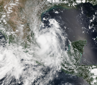
Hurricane Diana was a deadly tropical cyclone which made landfall in Mexico in August 1990. The fourth named storm and second hurricane of the season, Diana developed from a tropical wave in the southwestern Caribbean on August 4. Forming as a tropical depression, the system brushed Honduras before intensifying into a tropical storm the following day. Continuing to gradually strengthen, Diana made its first landfall in Mexico's Yucatán Peninsula as a strong tropical storm late on August 5. The cyclone weakened slightly due to land interaction, before emerging into the Bay of Campeche on August 6. Once over water, warm sea surface temperatures allowed Diana to quickly become a hurricane and later peak as a Category 2 on the Saffir–Simpson hurricane scale on August 7. Shortly thereafter, the storm made landfall near Tampico, Tamaulipas, with winds of 100 mph (160 km/h). Rapid weakening ensued once the storm moved over the high terrain of Mexico, with Diana diminishing to a tropical depression roughly 24 hours after moving onshore. The cyclone later emerged into the Gulf of California on August 9 shortly before dissipating. The remnant disturbance was monitored until losing its identity over Arizona on August 14.
Hurricane Gert was a large tropical cyclone that caused extensive flooding and mudslides throughout Central America and Mexico in September 1993. The seventh named storm and third hurricane of the annual hurricane season, Gert originated as a tropical depression from a tropical wave over the southwestern Caribbean Sea on September 14. The next day, the cyclone briefly attained tropical storm strength before moving ashore in Nicaragua and proceeding through Honduras. It reorganized into a tropical storm over the Gulf of Honduras on September 17, but weakened back to a depression upon crossing the Yucatán Peninsula. Once over the warm waters of the Bay of Campeche, Gert quickly strengthened into a Category 2 hurricane by September 20. The hurricane made a final landfall on the Gulf Coast of Mexico near Tuxpan, Veracruz, with peak winds of 100 mph (160 km/h). The rugged terrain disrupted the cyclone's structure; Gert entered the Pacific Ocean as a depression near the state of Nayarit on September 21, where it briefly redeveloped a few strong thunderstorms before dissipating at sea five days later.

Tropical Storm Bret was a short-lived tropical storm in June 2005 that had damaging effects in Veracruz, Mexico. The second named storm of the season, Bret quickly developed from a tropical wave on June 28 in the Bay of Campeche. Failing to intensify beyond minimal tropical storm intensity, the system made landfall in Veracruz the following day. It rapidly weakened once onshore, dissipating early on June 30. The storm brought heavy rainfall to Veracruz, San Luis Potosí, and Tamaulipas with the former suffering the brunt of the impacts. Approximately 11,000 people were adversely affected by widespread flooding. A total of 2,129 homes were damaged and 25 were destroyed, mostly in the city of Naranjos. Three people were killed in storm-related incidents and total losses exceeded 100 million pesos (US$9.3 million). The Government of Veracruz declared emergencies for nine municipalities and released tens of millions of pesos in relief aid in conjunction with national agencies.
Tropical Storm Marco was one of the smallest tropical cyclones on record by radius of winds from center. The thirteenth named storm of the 2008 Atlantic hurricane season, Marco developed out of a broad area of low pressure over the northwestern Caribbean during late September 2008. Influenced by a tropical wave on October 4, a small low-level circulation center developed over Belize. After crossing the southern end of the Yucatán Peninsula and emerging into the Bay of Campeche, the low was declared Tropical Depression Thirteen early on October 6. The depression quickly intensified into a tropical storm and was given the name Marco later that day. Marco reached its peak intensity with winds of 65 mph (100 km/h) early on October 7. Around this time, tropical storm force winds extended 11.5 miles (18.5 km) from the center of the storm, making Marco the smallest tropical cyclone on record. Around 1200 UTC, Marco made landfall near Misantla, Veracruz. The storm rapidly weakened after landfall, dissipating later that day.
Hurricane Andres was the first named storm and hurricane of the 2009 Pacific hurricane season. Forming on June 21, Andres gradually intensified as it tracked along the Mexican coastline. Deep convection developed around the center of circulation and by June 23, the storm attained hurricane-status, peaking with winds of 80 mph (130 km/h). Upon attaining this intensity, the storm featured a developing eyewall within a central dense overcast. Within 36 hours, the storm rapidly degenerated, having most of the convection being displaced by high wind shear, becoming a non-tropical trough during the afternoon of June 24.

Hurricane Alex was the first tropical cyclone of the 2010 Atlantic hurricane season, and a rare June Atlantic hurricane. Originating from an area of disturbed weather on June 25, 2010, it slowly developed in the western Caribbean Sea and struck Belize as a strong tropical storm. After entering the Gulf of Mexico, Alex became very large and encountered conditions favorable for gradual development. Early on June 30, the cyclone attained hurricane status as it approached northeastern Mexico, the first June hurricane in the Atlantic basin since Hurricane Allison in 1995, and the storm rapidly intensified just off the coast of Tamaulipas. Alex made landfall near Soto la Marina as a Category 2 hurricane on the Saffir-Simpson Hurricane Wind Scale. Alex rapidly weakened after landfall, with the storm losing its tropical status on July 2, before fully dissipating on July 6.
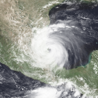
Hurricane Karl was the most destructive tropical cyclone on record to strike the Mexican state of Veracruz. The eleventh tropical storm, sixth hurricane, and fifth and final major hurricane of the 2010 Atlantic hurricane season, Karl formed from an area of low pressure which had formed off of the northern coast of Venezuela on September 11. It crossed the Caribbean and was upgraded to Tropical Storm Karl on September 14. The cyclone made landfall on the Yucatan Peninsula of Mexico as a strong tropical storm, and then rapidly strengthened in the Bay of Campeche before it made landfall near the city of Veracruz, on the central Mexican Gulf coast, as a major hurricane. This marked the first known time that a major hurricane existed in the Bay of Campeche. Afterwards, the storm rapidly weakened over the mountains of Mexico and dissipated on September 18.

Tropical Storm Arlene, the first named storm of the 2011 Atlantic hurricane season, brought blustery conditions to much of eastern Mexico in late June to early July 2011. Arlene originated from an Atlantic tropical wave, which crossed the Yucatán Peninsula before emerging over warm waters in the Bay of Campeche. Despite moderate wind shear, the disturbance strengthened and developed a surface circulation, prompting the National Hurricane Center to declare it a tropical storm on June 28. Arlene remained vigorous for most of its existence; the storm peaked in intensity with winds of 65 mph (100 km/h) on June 30, just before making landfall on the coast of Veracruz. Crossing the mountains of eastern Mexico, Arlene weakened to a depression before dissipating early on July 1.

Hurricane Manuel brought widespread flooding across much of Mexico in September 2013, in conjunction with Hurricane Ingrid. The fifteenth named storm and seventh hurricane of the annual hurricane season, Manuel originated from a strong area of low pressure south of Acapulco on September 13. Within favorable conditions aloft, the storm intensified into a tropical storm as it tracked northward. The following day, Manuel curved westward and strengthened to a point just shy of hurricane intensity before making its first landfall at that intensity on September 15. Due to interaction with land, the tropical storm quickly weakened, and its center dissipated over western Mexico on September 16. However, the storm's remnants continued to track northwestward into the Gulf of California, where they reorganized into a tropical cyclone the next day. Manuel regained tropical storm status on September 18 as it began to curve northeastward. Shortly thereafter, Manuel attained Category 1 hurricane intensity, before making its final landfall just west of Culiacán at peak intensity. Over land, Manuel quickly weakened due to interaction with Mexico's high terrain, and the storm dissipated early on September 20.

Hurricane Ingrid was one of two tropical cyclones, along with Hurricane Manuel, to strike Mexico within a 24-hour period, the first such occurrence since 1958. Ingrid was the ninth named storm and second hurricane of the 2013 Atlantic hurricane season. It formed on September 12 in the Gulf of Mexico from a broad disturbance that also spawned Manuel in the eastern Pacific. After initially moving westward toward Veracruz, Ingrid turned northeastward away from the coast. Favorable conditions allowed it to attain hurricane status on September 14, and the next day Ingrid attained peak winds of 140 km/h (85 mph). Subsequently, increased wind shear weakened the convection as the storm turned more to the northwest and west. On September 16, Ingrid made landfall just south of La Pesca, Tamaulipas in northeastern Mexico as a strong tropical storm, and dissipated the next day. The hurricane was also the last one to form in the Gulf of Mexico until Hurricane Hermine in 2016.

Tropical Storm Boris was a weak and short-lived tropical cyclone that brought rainfall to the Isthmus of Tehuantepec and surrounding areas in June 2014. The second named storm of the season, Boris developed from the interaction of a low-level trough and a Kelvin wave south of Mexico late on June 2. Initially a tropical depression, the system moved generally northward and strengthened into Tropical Storm Boris by midday on June 3. About six hours later, Boris peaked with maximum sustained winds of 45 mph (75 km/h) – indicative of a weak tropical storm. By early on June 4, interaction with land caused the storm to weaken, deteriorating to a tropical depression. Later that day, Boris degenerated into a remnant low pressure, before fully dissipating over the Gulf of Tehuantepec on June 5.
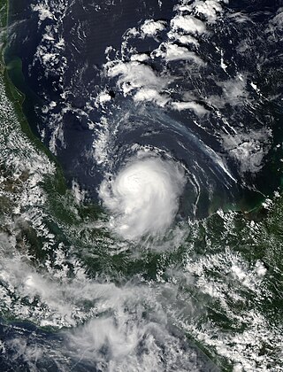
Tropical Storm Dolly was a short-lived and disorganized tropical cyclone that caused moderate damage across Tamaulipas, Mexico, in early September 2014. Originating from a tropical wave, the system first became a tropical depression late on September 1 while situated over the Bay of Campeche. Dolly struggled against strong wind shear for the duration of its existence. The large system featured multiple circulations, sometimes becoming a new dominant center and other times simply rotating around a mean vortex. As a result, multiple center relocations occurred along its general west-northwest track. Dolly eventually made landfall in Tamaulipas on September 3 before degenerating into a remnant low. The system subsequently dissipated the following day.

Hurricane Katia was a strong Atlantic hurricane which became the most intense storm to hit the Bay of Campeche since Karl in 2010. The eleventh named storm and sixth hurricane of the exceptionally active 2017 Atlantic hurricane season, Katia originated on September 5, out of a broad low-pressure area that formed in the Bay of Campeche. Located in an area of weak steering currents, Katia meandered around in the region, eventually intensifying into a hurricane on September 6. The nascent storm eventually peaked as a 105 mph (165 km/h) Category 2 hurricane on the Saffir–Simpson scale while it began to move southwestward. However, land interaction began to weaken the hurricane as it approached the Gulf Coast of Mexico. Early on September 9, Katia made landfall near Tecolutla at minimal hurricane intensity. The storm quickly dissipated several hours later, although its mid-level circulation remained intact and later spawned what would become Hurricane Otis in the Eastern Pacific.

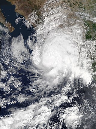
Hurricane Bud was a Category 4 hurricane that brought winds and severe flooding to Mexico throughout its existence as a tropical cyclone in June 2018. It was the second named storm, hurricane, and major hurricane of the 2018 Pacific hurricane season. Bud originated from a tropical wave that departed from Western Africa on May 29. It traveled across the Atlantic Ocean before entering the Northeast Pacific Ocean late on June 6. The system moved towards the northwest and steadily organized, becoming a tropical depression on June 9 and Tropical Storm Bud early the next day. Favorable upper-level winds, ample moisture aloft, and warm sea surface temperatures allowed the storm to rapidly intensify to a hurricane late on June 10, and further to a major hurricane on the following day. Bud ultimately peaked the next morning with maximum sustained winds of 140 mph (230 km/h) and a minimum central pressure of 943 mbar. Its track curved more northward while the storm rapidly succumbed to the effects of upwelling. Bud made landfall on Baja California Sur as a minimal tropical storm early on June 15. On the next day, land interaction and increasing wind shear caused Bud to degenerate into a post-tropical cyclone. It opened up into a trough of low-pressure on June 16. The remnants of Bud moved towards the Southwestern United States, bringing tropical moisture and gusty winds to the region.

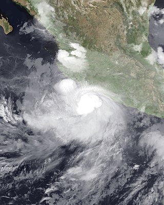
Tropical Storm Carlotta was a moderately strong tropical cyclone that caused flooding in several states in southwestern and central Mexico. Carlotta, the third named storm of the 2018 Pacific hurricane season, formed as the result of a breakdown in the Intertropical Convergence Zone. On June 12, a broad area of low pressure developed several hundred miles south of Mexico and strengthened into a tropical storm by June 15. The next day, the system stalled unexpectedly within a favorable environment, which led to more intensification than originally anticipated. Early on June 17, Carlotta reached peak intensity with maximum sustained winds of 65 mph (100 km/h) and a minimum central pressure of 997 mbar while located only 30 mi (50 km) south-southeast of Acapulco. The system then began to interact with land and experience wind shear, which resulted in the storm weakening to tropical depression status later in the day. The system weakened to a remnant low early on June 19 and dissipated several hours later.

Tropical Storm Vicente was an unusually small tropical cyclone that made landfall as a tropical depression in the Mexican state of Michoacán on October 23, 2018, causing deadly mudslides. The 21st named storm of the 2018 Pacific hurricane season, Vicente originated from a tropical wave that departed from Africa's western coast on October 6. The wave traveled westward across the Atlantic and entered the Eastern Pacific on October 17. The disturbance became better defined over the next couple of days, forming into a tropical depression early on October 19. Located in an environment favorable for further development, the system organized into Tropical Storm Vicente later that day.

Potential Tropical Cyclone Seventeen-E was a tropical disturbance that caused damaging floods in Southern Mexico, Guatemala, and El Salvador in mid-October 2019. A tropical wave entered the Eastern Pacific Ocean during October 13–14, and a low-pressure area developed by October 14 to the west of Nicaragua. Convection, also known as thunderstorm activity, associated with the system increased in both intensity and extent during October 15, while the system was south of Guatemala. The National Hurricane Center initiated advisories on the system as Potential Tropical Cyclone Seventeen-E on October 16, anticipating that the system would become a tropical cyclone before reaching the southern coast of Mexico. During its existence as a potential tropical cyclone, Seventeen-E had winds of 35 mph (55 km/h) and a pressure of 1,005 mbar (29.68 inHg). As the storm tracked northwestward towards the coast, its structure decayed, and the chance of tropical cyclogenesis decreased markedly. The disturbance made landfall between Bahias de Huatulco and Salina Cruz, Oaxaca, during mid-day October 16 and dissipated a few hours later.

Tropical Storm Hernan was a short-lived tropical cyclone that brought widespread flooding and destructive mudslides to southwestern Mexico in late August 2020. Hernan was the thirteenth tropical cyclone and eighth named storm of the 2020 Pacific hurricane season. The system developed from a low-pressure area to the southwest of Mexico on August 26, as a low-end tropical storm. Moving generally northward and paralleling the west coast of Mexico, Hernan was hindered by a high wind shear environment and only slightly strengthened. The cyclone achieved its peak intensity around 06:00 UTC on August 27 with maximum sustained winds of 70 km/h (45 mph) and a minimum barometric pressure of 1,001 mbar (29.6 inHg). Passing just offshore of the state of Jalisco, Hernan turned west and degenerated to a remnant low on August 28. The low passed near the southern tip of the Baja California Peninsula later that day and dissipated shortly thereafter.
Tropical Storm Ivo was a tropical cyclone that brought heavy rainfall to five states in Mexico, causing severe flooding during August 2019. The tenth tropical cyclone and ninth named storm of the 2019 Pacific hurricane season, Ivo arose from a low-pressure area that spawned south of Guatemala on August 16. The low-pressure system gradually organized over the next several days as it tracked west-northwestward. The system coalesced into a tropical depression early on August 21 and strengthened into Tropical Storm Ivo several hours later. Located within a favorable environment of moist air and warm sea surface temperatures, the cyclone quickly intensified, peaking the next day with 1-minute maximum sustained winds of 70 mph (110 km/h) and a pressure of 990 mbar (29.23 inHg). Increasing wind shear caused the storm's intensification to level off later that day, as the system turned towards the north-northwest. Ivo passed by Clarion Island midday on August 23, generating winds of 60 mph (100 km/h) on the island. Wind shear caused Ivo to significantly degrade in structure and intensity during the next couple of days. Cold sea surface temperatures, as well as dry and stable air, caused the cyclone to degenerate into a remnant low early on August 25. The low meandered over the eastern Pacific before opening up into a trough of low pressure early on August 27.
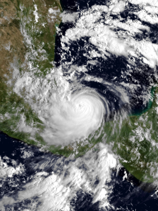
Tropical Storm Dolores was a strong tropical storm that made landfall in southwestern Mexico in June 2021. The fourth named storm of the 2021 Pacific hurricane season, Dolores developed from a low-pressure area that formed offshore the Mexican state of Oaxaca on June 16, 2021. The low steadily developed organized deep convection and a closed surface circulation, becoming Tropical Depression Four-E around 06:00 UTC June 18. The depression strengthened into a tropical storm nine hours later and was named Dolores. Gradually approaching the southwestern coast of Mexico, Dolores steadily intensified despite its close proximity to land. The storm reached its peak intensity around 15:00 UTC June 19 with maximum sustained winds of 115 km/h (70 mph) and a minimum barometric pressure of 29.2 inHg (989 mbar), just below hurricane strength. Shortly after reaching this intensity, Dolores made landfall just northwest of Punta San Telmo, near the Colima–Michoacán state border. The storm rapidly weakened as it moved inland over Mexico and dissipated early on June 20 over the state of Zacatecas.


