
Lajas is a town and municipality of Puerto Rico located in the Lajas Valley in southwestern Puerto Rico, on the southern coast of the island, bordering the Caribbean Sea, south of San Germán and Sabana Grande; east of Cabo Rojo; and west of Guánica. Lajas is spread over 11 barrios plus Lajas Pueblo. It is part of the San Germán-Cabo Rojo Metropolitan Statistical Area.

Cabo Rojo is a city and municipality situated on the southwest coast of Puerto Rico and forms part of the San Germán–Cabo Rojo metropolitan area as well as the larger Mayagüez–San Germán–Cabo Rojo Combined Statistical Area.

Dr. Rebekah Colberg, was a Puerto Rican athlete, who was known as "The Mother of Women's Sports in Puerto Rico". Colberg participated in various athletic competitions in the 1938 Central American and Caribbean Games celebrated in Panama where she won the gold medals in Discus and Javelin throw.
Caborrojeños Pro Salud y Ambiente, Inc. is a non-profit environmentalist organization based in Cabo Rojo, Puerto Rico.

Faro Los Morrillos de Cabo Rojo, also known as Los Morrillos Light, is a historic lighthouse located in Los Morrillos cape in the municipality of Cabo Rojo, Puerto Rico.
Efrén Pérez Rivera was a Puerto Rican environmentalist leader and college professor. He got married at the age of 28 with Pezinka Berenguer, till the day he died. He had three children with her, Efrén Pérez Berenguer, Manuel Pérez Berenguer, and José Luis Pérez Berenguer
Cabo is Spanish, Portuguese and Galician for cape. It may refer to:
Antonio "Tony" J. Fas Alzamora is a Puerto Rican politician and Senator. He is currently the longest-serving legislator in the history of Puerto Rico, having served in ten Legislative Assemblies, one House of Representatives, and nine Senates.
Puerto Rico Highway 301 (PR-301) is a main highway in Cabo Rojo, Puerto Rico. It begins in PR-101, close to PR-100, and goes south all the way to Los Morrillos Light, where it ends. It is the main access to the lighthouse, the Cabo Rojo cliffs, and Playa Sucia.

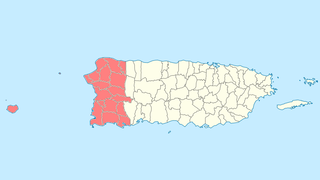
The San Germán-Cabo Rojo Metropolitan Statistical Area is a United States Census Bureau defined Metropolitan Statistical Area (MSA) in southwestern Puerto Rico. A July 1, 2009 Census Bureau estimate placed the population at 148,559, a 9.06% increase over the 2000 census figure of 136,212.

Boquerón is a barrio in the municipality of Cabo Rojo, Puerto Rico. Its population in 2010 was 5,373. The village is one of the main tourist attractions in the southwestern part of the island. In 2000, its population was 4,963.

Cabo Rojo National Wildlife Refuge is located on the southwestern side of Puerto Rico in the municipio of Cabo Rojo. It was established in 1974, when 587 acres of land were obtained by the U.S. Fish and Wildlife Service from the Central Intelligence Agency which had operated the Caribbean Bureau of the Foreign Broadcast Information Service there for a number of years. The 1,836 acres (7.43 km2) refuge is a habitat for number of native bird species including the endangered yellow-shouldered blackbird also known as la mariquita de Puerto Rico or capitán. Many birds find their way to the refuge while migrating between North and South America.

Isla de Ratones also known as Cayo Ratones or Isla Ratones is a small island located near the Joyuda Lagoon in Cabo Rojo, Puerto Rico. The island is a popular spot for snorkeling and bathing.
Porta del Sol is a tourism region in western Puerto Rico. It consists of 17 municipalities in the western area: Quebradillas, Isabela, San Sebastián, Moca, Aguadilla, Aguada, Rincón, Añasco, Mayagüez, Las Marías, Maricao, Hormigueros, San Germán, Sábana Grande, Guánica, Lajas and Cabo Rojo. Porta del Sol was established in 2003 by the Puerto Rico Tourism Company. The name translates to "Doorway to the Sun"

Club Deportivo del Oeste is a private club in Cabo Rojo, Puerto Rico which has the largest marina and one of only two golf courses in the Porta del Sol region of Puerto Rico.

Sierra Bermeja is a mountain range in southwestern Puerto Rico. It forms the southern boundary of the Lajas Valley and it is bordered by La Parguera in the Caribbean Sea coast. It extends from the municipality of Cabo Rojo in the west to Lajas in the east. It consists of a combination of volcanic rocks, completely crossed by serpentinite and amphibolite faults, which could well be the oldest known rock in Puerto Rico. The mountains were used by the Taíno people as refuge from the Spanish, and then by smugglers during the Spanish colonization.
Isla de Ratones may refer to:

Boquerón State Forest is one of the 20 forestry units that make up the public forest system of Puerto Rico. Despite its name, the Boquerón State Forest is not only located in Boquerón, Cabo Rojo but also spans almost 5,000 acres across the municipalities of Cabo Rojo, Lajas and Mayagüez. The forest area is also known for its limestone cliffs, the lighthouse, and the salt flats which have been a source of salt since the pre-Hispanic era and dating to 700 C.E. it is considered one of the oldest industries in the Americas.

Los Morrillos de los Cabos Rojos or more commonly known as Los Morrillos de Cabo Rojo, is a cape and tombolo landform located in southwestern Puerto Rico in the municipality of Cabo Rojo. Los Morrillos is an excellent example of a tombolo, or a tied island, with two sand pits. The cape resembles a letter Y with its two promontories or morrillos being connected through sand pits which enclose a saltwater lagoon. The landform was designated a National Natural Landmark in 1980, and the site includes mangroves, beaches, important bird nesting areas, limestone caves, cliffs and rock formations. The reddish-colored limestone cliffs give the name to the town and municipality of Cabo Rojo.