Puerto Rico, officially the Commonwealth of Puerto Rico, is an archipelagic island U.S. territory comprised of the eponymous main island of Puerto Rico and 142 smaller islands, including Vieques, Culebra, and Mona. It is located between the Greater and Lesser Antilles in the northeastern Caribbean Sea, east of Hispaniola, west of Saint Thomas, north of Venezuela, and south of the Puerto Rico Trench. Measuring 177 km in length and 65 km in width with a land area of 8,868 sq km, the main island is the 3rd largest in the U.S., 4th in the Caribbean, 29th in the Americas, and 81st in the world, making it the 174th largest country or dependency by surface area. With 3.2 million residents, it is the 2nd largest in the U.S., 4th in the Caribbean, 4th in the Americas, and 31st in the world, making it the 136th largest country or dependency by population.

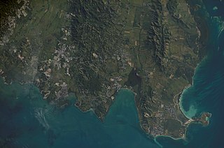
Cabo Rojo is a city and municipality situated on the southwest coast of Puerto Rico and forms part of the San Germán–Cabo Rojo metropolitan area as well as the larger Mayagüez–San Germán–Cabo Rojo Combined Statistical Area.

The Puerto Rican dry forests are a tropical dry forest ecoregion located in southwestern and eastern Puerto Rico and on the offshore islands. They cover an area of 1,300 km2 (500 sq mi). These forests grow in areas receiving less than 1,000 mm (39 in) of rain annually. Many of the trees are deciduous, losing their leaves during the dry season which normally lasts from December to April.
Caborrojeños Pro Salud y Ambiente, Inc. is a non-profit environmentalist organization based in Cabo Rojo, Puerto Rico.

Faro Los Morrillos de Cabo Rojo, also known as Los Morrillos Light, is a historic lighthouse located on the capes of Los Morrillos de Cabo Rojo in the municipality of Cabo Rojo, Puerto Rico.

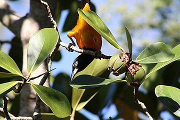
The yellow-shouldered blackbird, known in Puerto Rican Spanish as mariquita de Puerto Rico or capitán, is a species of blackbird endemic to Puerto Rico. It has black plumage with a prominent yellow patch on the wing. Adult males and females are of similar appearance. The species is predominantly insectivorous.
Caribbean Islands National Wildlife Complex is an administrative unit of the United States Fish and Wildlife Service which oversees National Wildlife Refuges in Puerto Rico, the U.S. Virgin Islands, and Navassa Island of the U.S. Minor Outlying Islands. The NWR complex also reintroduces the critically endangered Puerto Rican parrot into the wild.

Libidibia monosperma is a species of legume in the family Fabaceae, with the common names cóbana negra and cóbana polisandro. It is found in the Dominican Republic, Puerto Rico, and the United States Virgin Islands. It is a federally listed threatened species of the United States.

Laguna Tortuguero Natural Reserve is a natural reservoir located between the municipalities of Vega Baja and Manatí in Puerto Rico.
Cullingford Field was an airstrip owned and operated by the United States Fish and Wildlife Service near Boquerón in the municipality of Cabo Rojo, Puerto Rico. Located within the Cabo Rojo National Wildlife Refuge, it was used exclusively by Fish and Wildlife personnel.

Boquerón is a barrio in the municipality of Cabo Rojo, Puerto Rico. Its population in 2010 was 5,373. The village of Boquerón, located on the Boquerón Bay is one of the main tourist attractions in the southwestern part of the island. In 2000, its population was 4,963.
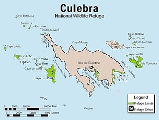
The Culebra National Wildlife Refuge is a National Wildlife Refuge in Puerto Rico. It is part of the Caribbean Islands National Wildlife Refuge Complex, which is a unit of the U.S. Fish and Wildlife Service. It is the site of the former Camp Roosevelt.

Porta del Sol, or simply West Region, is a tourism region in western Puerto Rico. Porta del Sol was the first tourism region to be established by the Puerto Rico Tourism Company. It consists of 17 municipalities in the western area: Quebradillas, Isabela, San Sebastián, Moca, Aguadilla, Aguada, Rincón, Añasco, Mayagüez, Las Marías, Maricao, Hormigueros, San Germán, Sabana Grande, Guánica, Lajas and Cabo Rojo.
Caño Tiburones is a wetland and nature reserve located in the northern coast of Puerto Rico in the municipalities of Arecibo and Barceloneta. This is one of the largest wetlands in Puerto Rico, covering almost 7,000 acres. A large portion of the swamp, located in Arecibo, is protected as the Caño Tiburones Nature Reserve.

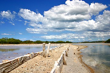
Boquerón State Forest is one of the 20 forestry units that make up the public forest system of Puerto Rico. Despite its name, the Boquerón State Forest is not only located in Boquerón, Cabo Rojo but also spans almost 5,000 acres across the municipalities of Cabo Rojo, Lajas and Mayagüez. The forest area is also known for its limestone cliffs, the lighthouse, and the salt flats which have been a source of salt since the pre-Hispanic era and, dating to 700 C.E., they are considered to be one of the oldest industries in the Americas.

Los Morrillos de los Cabos Rojos or more commonly known as Los Morrillos de Cabo Rojo, is a cape and tombolo landform located in southwestern Puerto Rico in the municipality of Cabo Rojo. Los Morrillos is an excellent example of a tombolo, or a tied island, with two sand pits. The cape resembles a letter Y with its two promontories or morrillos being connected through sand pits which enclose a saltwater lagoon. The landform was designated a National Natural Landmark in 1980, and the site includes mangroves, beaches, important bird nesting areas, limestone caves, cliffs and rock formations. The reddish-colored limestone cliffs give the name to the town and municipality of Cabo Rojo.
Boquerón Bay is a bay of the Mona Passage located on the coast of Cabo Rojo, Puerto Rico. El Poblado de Boquerón, or just Boquerón for short, located in the barrio of the same name, is the main settlement located along the bay. The bay is a major tourist destination as it hosts the Boquerón Beach and Los Pozos Beach. The Boquerón Lagoon and the Boquerón Iris Alameda Wildlife Refuge are located immediately to the east of the bay next to Boquerón Beach.
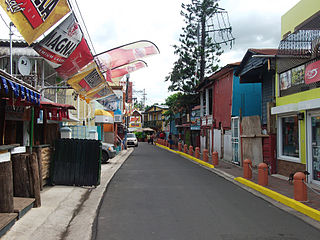
El Poblado de Boquerón is a coastal village which represents the downtown or main urban nucleus of the barrio (district) Boquerón of Cabo Rojo, located on the northeast of Boquerón Bay. The village is a major tourist destination, and it is renown in Puerto Rico for its gastronomy, boathouses, beach, nightlife and its yearly pride parade.

Punta Guaniquilla is a headland or small peninsula located immediately to the south of Buyé Beach and north of Boquerón Bay in the municipality of Cabo Rojo, Puerto Rico. The entirety of the headland is protected as the Punta Guaniquilla Nature Reserve by the Conservation Trust of Puerto Rico and the Puerto Rico Department of Natural and Environmental Resources since 1977, making it one of the oldest nature reserves officially protected by Puerto Rico Law #150.