
Cordillera Central, is the main mountain range in Puerto Rico. The range crosses the island from west to east and divides it into its northern and southern coastal plains. The Cordillera Central runs eastward from the municipality of Maricao in the west to Aibonito in the central eastern region, and on to the Caribbean in the southeast through the Sierra de Cayey. The Central Mountain Range consists of the Cordillera Central proper and numerous subranges, foothills and ridges that extend throughout the island. Cerro de Punta is both the highest peak of the Cordillera Central and the highest point in Puerto Rico. The Sierra de Luquillo, where El Yunque is located, is sometimes included as a subrange or eastward extension of the Cordillera Central.

The Puerto Rican spindalis is a bird endemic to the island of Puerto Rico, where it is commonly known as reina mora. The species is widely distributed throughout the island and is an important part of the Puerto Rican ecosystem because of its help in seed dispersal and plant reproduction. The Puerto Rican spindalis is the unofficial national bird of Puerto Rico.

Spindalis is a genus consisting of four non-migratory species of bird. It is the only genus in the family Spindalidae. The species are mostly endemic to the West Indies; exceptions include populations of western spindalises on Cozumel Island, off the Yucatán Peninsula's east coast, and in extreme southeastern Florida. The species were traditionally considered aberrant members of the tanager family Thraupidae. Taxonomic studies recover them as a sister group to the Puerto Rican tanager, and some group Spindalidae and Nesospingidae within the Phaenicophilidae.
The Guánica State Forest, popularly known as the Guánica Dry Forest is a subtropical dry forest located in southwest Puerto Rico. The area was designated as a forest reserve in 1919 and a United Nations Biosphere Reserve in 1981. It is considered the best preserved subtropical dry forest and the best example of dry forest in the Caribbean.

The San Juan Botanical Garden, officially known as the Botanical Garden of the University of Puerto Rico, is located in the Caribbean city of San Juan, capital of Puerto Rico. This lush 300-acre (1.2 km2) “urban garden” of native and exotic flora serves as a laboratory for the study, conservation and enrichment of plants, trees, flowers, grasses and many other plants. Seventy-five acres are landscaped and open to the general public as well as researchers.

Laguna Tortuguero Natural Reserve is a natural reservoir located between the municipalities of Vega Baja and Manatí in Puerto Rico.
Lluidas Vale, also known as Worthy Park, is a settlement in Saint Catherine Parish, Jamaica. It has a population of 3,413 as of 2009.
Cambalache State Forest and Reserve is a nature reserve and one of the 20 state forests in the territory of Puerto Rico. The Cambalache State Forest is located in the municipalities of Arecibo and Barceloneta in northern Puerto Rico.
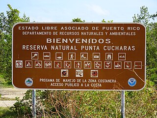
Reserva Natural Punta Cucharas is a nature reserve in Barrio Canas, Ponce, Puerto Rico. It consists of both a land area component as well as an offshore marine area. The land component has an area of 698 cuerdas while the marine component has an expanse of 3,516 cuerdas, for a total area of 4,214 cuerdas. The Reserve consists of mangrove ecosystems, coastal sand dunes, a saline lagoon known as Laguna Las Salinas, open water, and a century-old local community. The lagoon occupies and area of 347,898 m2 Ecological protection is managed and enforced by the Puerto Rico Department of Natural and Environmental Resources. Eight activities are allowed at the Reserve: scuba diving, boating, fishing, hiking, sun bathing, photography, bird watching and canoeing. Activities prohibited are: Camping, crabbing/trapping, horseback riding, water crafting, and hunting. Pets, ATVs, and fireplaces are also prohibited.

The Monte Choca State Forest is a 244.6-acre (0.990 km2), tropical moist forest, located in the municipality of Corozal in Puerto Rico. It is owned and maintained by the commonwealth of Puerto Rico and co-maintained by local conservation groups.

Carite State Forest is a state forest and nature reserve located in the Sierra de Cayey mountain range in southeastern Puerto Rico. The forest extends over approximately 2,600 hectares and is located in the municipalities of Caguas, Cayey, Guayama, Patillas and San Lorenzo. The forest is located along the Ruta Panorámica, which offers access to the forest.

Guilarte State Forest is one of the 20 forests that make up the public forests system in Puerto Rico. The forest is located in the eastern half of the Central Mountain Range or Cordillera Central. The main geographical feature of the forest reserve is Monte Guilarte, which is Puerto Rico's 7th highest mountain at 3,950 feet above sea level. While Monte Guilarte is located in the municipality of Adjuntas, the forest's borders also include parts of Guayanilla, Peñuelas and Yauco.
Los Tres Picachos State Forest is one of the 20 forests that make up the public forest system of Puerto Rico. The forest is located in the Central Mountain Range or Cordillera Central, along the Los Tres Picachos mountain ridge, one of the island's highest mountains, named after the distinctive three peaks of the highest mountain in the forest. The state forest is located in the municipalities of Jayuya and Ciales.

Guajataca State Forest is one of the 20 forests that make up the public forest system of Puerto Rico. The Guajataca Forest is located in the northwestern part of Puerto Rico, along the Northern Karst zone in the municipality of Isabela and municipality of Quebradillas, and is near Camuy and San Sebastián. The forest is renowned for its ecological diversity, the mogotes and karstic formations, and its numerous caves and canyons. It also has the largest trail system of any Puerto Rican state forest.
Susúa State Forest is one of the 20 forest units that make up the public forest system of Puerto Rico. This forest is located in the southeastern foothills of the Central Mountain Range or Cordillera Central, in the municipalities of Sabana Grande and Yauco. Most of the forest, particularly the lower parts, are of secondary growth as the land had originally been deforested and used for cattle grazing, timber production and agriculture. The forest is an important habitat for the endangered Puerto Rican nightjar.

Vega State Forest is a state forest of Puerto Rico located in the municipalities of Vega Alta and Vega Baja. The subtropical moist forest is located in the northern coast of Puerto Rico in the middle of the karst zone known as the Carso Norteño, and it contains features typical of such geography such as sinkholes, caves and mogotes. It was designated a nature reserve in 1952 and it is fully protected by the Puerto Rico Forest laws of 1975. The forest has a total area of 1,150 acres divided into six forest units throughout the municipalities of Vega Alta and Vega Baja.

