
El Yunque National Forest, formerly known as the Caribbean National Forest, is a forest located in northeastern Puerto Rico. It is the only tropical rainforest in the United States National Forest System and the United States Forest Service. El Yunque National Forest is located on the slopes of the Sierra de Luquillo mountains, encompassing more than 28,000 acres of land, making it the largest block of public land in Puerto Rico.

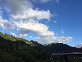
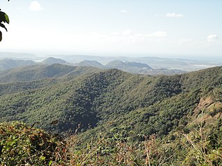
Cordillera Central, is the main mountain range in Puerto Rico. The range crosses the island from west to east and divides it into its northern and southern coastal plains. The Cordillera Central runs eastward from the municipality of Maricao in the west to Aibonito in the central eastern region, and on to the Caribbean in the southeast through the Sierra de Cayey. The Central Mountain Range consists of the Cordillera Central proper and numerous subranges, foothills and ridges that extend throughout the island. Cerro de Punta is both the highest peak of the Cordillera Central and the highest point in Puerto Rico. The Sierra de Luquillo, where El Yunque is located, is sometimes included as a subrange or eastward extension of the Cordillera Central.
The Guánica State Forest, popularly known as the Guánica Dry Forest is a subtropical dry forest located in southwest Puerto Rico. The area was designated as a forest reserve in 1919 and a United Nations Biosphere Reserve in 1981. It is considered the best preserved subtropical dry forest and the best example of dry forest in the Caribbean.
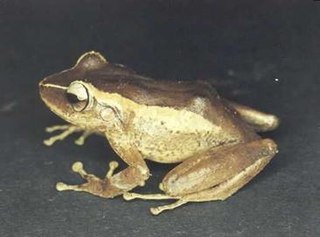
Eleutherodactylus portoricensis is a frog native to Puerto Rico that belongs to the family Eleutherodactylidae. Its vernacular English names are upland coqui, mountain coqui, and Puerto Rican robber frog. The species’ range spans the Luquillo Mountains of northeastern Puerto Rico and the Cordillera Central, which forms the highland “backbone” of Puerto Rico and includes an eastern extension beginning at the city of Cayey. However, the species is likely extirpated from the western Cordillera Central.

Eleutherodactylus juanariveroi, the Puerto Rican wetland frog or, is an endangered species of coqui, a frog species, endemic to Puerto Rico. It was discovered in 2005 by Neftalí Rios, and was named after Puerto Rican herpetologist Juan A. Rivero, in honor of his contributions to Puerto Rican herpetology.

Toro Negro State Forest is one of the 21 forests that make up the public forests system in Puerto Rico. It is also Puerto Rico's highest cloud forest. It is in the Cordillera Central region of the island and covers 8,204 cuerdas, of mountains. Toro Negro's mountains have heights reaching up to 4,400 feet (1,300 m) and include Cerro de Punta, Cerro Jayuya and Cerro Rosa, the three highest peaks in the island. Nested among these mountains is Lake Guineo, the island's highest lake. The forest has 18 kilometers (11 mi) of trails, an observation tower, two natural swimming pools (Spanish:"charcos"), camping and picnic areas, nine rivers, and numerous creeks and waterfalls. The forest spans areas within the municipalities of Ponce, Jayuya, Orocovis, Ciales, and Juana Díaz, and consists of seven non-contiguous tracts of land. The largest contiguous segment of the forest is located in the municipalities of Ponce and Jayuya. Some 40% of the area of Toro Negro State Forest is located in Ponce's Barrio Anón.
Cambalache State Forest and Reserve is a nature reserve and one of the 20 state forests in the territory of Puerto Rico. The Cambalache State Forest is located in the municipalities of Arecibo and Barceloneta in northern Puerto Rico.
Polystichum calderonense is a rare species of fern known by the common name Monte Guilarte hollyfern. It is endemic to Puerto Rico, where it occurs in the Peñuelas and Guilarte Commonwealth Forests. There are only 57 individual plants remaining. It is a federally listed endangered species of the United States.

Magnolia portoricensis is a tree of the Caribbean region. Its vernacular names include jagüilla and Puerto Rico magnolia. It is native to Puerto Rico and it is found in the Toro Negro State Forest. It is an endangered tree and endemic to Puerto Rico. It is a dicot and a part of the family Magnoliaceae. It is an uncommon tree, found primarily in the central and western mountains at 500 to 925 m above sea level.

The Monte Choca State Forest is a 244.6-acre (0.990 km2), tropical moist forest, located in the municipality of Corozal in Puerto Rico. It is owned and maintained by the commonwealth of Puerto Rico and co-maintained by local conservation groups.

Carite State Forest is a state forest and nature reserve located in the Sierra de Cayey mountain range in southeastern Puerto Rico. The forest extends over approximately 6,500 acres and is located in the municipalities of Caguas, Cayey, Guayama, Patillas and San Lorenzo. The forest is located along the Ruta Panorámica, which offers access to the forest.
Los Tres Picachos State Forest is one of the 20 forests that make up the public forest system of Puerto Rico. The forest is located in the Central Mountain Range or Cordillera Central, along the Los Tres Picachos mountain ridge, one of the island's highest mountains, named after the distinctive three peaks of the highest mountain in the forest. The state forest is located in the municipalities of Jayuya and Ciales.

San Patricio State Forest, also known as the San Patricio Urban Forest is one of the 20 forests that make up the public forest system of Puerto Rico. This is a secondary or second-growth forest is located in the Gobernador Piñero district of San Juan, between the neighborhoods of Villa Borinquen, Caparra Heights and Borinquen Towers complex. The urban forest has entrances on Roosevelt Avenue and Ensenada Street. The forest extends to almost 70 acres and it is the smallest protected area in the Puerto Rico state forest system. One of the most distinctive features of the forest is the mogote on its northern edge which can be observed from many parts of San Juan and Guaynabo. The forest is part of the Northern Karst.

Nuevo Milenio State Forest is one of the 20 forests that make up the public forest system of Puerto Rico. The forest is located east of the University of Puerto Rico Botanical Garden in the Sabana Llana Sur district of San Juan, making it one of the two state forests located within the capital's municipal boundaries.

Guajataca State Forest is one of the 20 forests that make up the public forest system of Puerto Rico. The Guajataca Forest is located in the northwestern part of Puerto Rico, along the Northern Karst zone in the municipality of Isabela and municipality of Quebradillas, and is near Camuy and San Sebastián. The forest is renowned for its ecological diversity, the mogotes and karstic formations, and its numerous caves and canyons. It also has the largest trail system of any Puerto Rican state forest.

Bosque del Pueblo is one of the 20 forest units that make up the public forest system of Puerto Rico. The 738-acres forest is located in the municipality of Adjuntas and it comprises a preserved zone which was endangered of being developed as a quarry between the years 1980 and 1995. The forest is located in lands shared by the Adjuntas barrios or districts of Vegas Arriba, Vegas Abajo and Pellejas de Adjuntas. In addition to preserving the forest the reserve is important to the preservation of the hydrological basins of the Pellejas and Viví Rivers, and many of the tributaries of the Arecibo River have their sources in the forest lands. The forest also functions as an ecological corridor between the Guilarte, Río Abajo and Toro Negro Forests.
Susúa State Forest is one of the 20 forest units that make up the public forest system of Puerto Rico. This forest is located in the southeastern foothills of the Central Mountain Range or Cordillera Central, in the municipalities of Sabana Grande and Yauco. Most of the forest, particularly the lower parts, are of secondary growth as the land had originally been deforested and used for cattle grazing, timber production and agriculture. The forest is an important habitat for the endangered Puerto Rican nightjar.

Vega State Forest is a state forest of Puerto Rico located in the municipalities of Vega Alta and Vega Baja. The subtropical moist forest is located in the northern coast of Puerto Rico in the middle of the karst zone known as the Carso Norteño, and it contains features typical of such geography such as sinkholes, caves and mogotes. It was designated a nature reserve in 1952 and it is fully protected by the Puerto Rico Forest laws of 1975. The forest has a total area of 1,150 acres divided into six forest units throughout the municipalities of Vega Alta and Vega Baja.

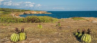
Mona and Monito Islands Nature Reserve consists of two islands, Mona and Monito, in the Mona Passage off western Puerto Rico in the Caribbean. Mona and Monito Islands Nature Reserve encompasses both land and marine area, and with an area of 38,893 acres it is the largest protected natural area in the Commonwealth of Puerto Rico. Much like the Galapagos Islands in the Pacific Ocean, the Mona and Monito Islands reserve represents a living laboratory for archaeological, biological, geological, oceanographical and wildlife management research.

