| No. | State Forest | Image | Municipalities | Est. | Area
(acres) | Area Ref | Description (and Facilities) |
|---|
| 1 | Aguirre |  | Guayama and Santa Isabel | 1918 | 2,390 | [23] | Mangrove forest includes the Punta Petrona Natural Reserve, a number of offshore keys and portions of the former Central Aguirre. [9] Borders the Jobos Bay National Estuarine Reserve in Salinas. (B, F, G, K, O) |
| 2 | Boquerón |  | Cabo Rojo and Lajas | 1918 | 4,630 | [24] | Subtropical dry and mangrove forests, incl. the Finca Belvedere, Cayo Ratones, Joyuda Lagoon and La Parguera natural reserves, the Iris Alameda Wildlife Refuge, and the Cabo Rojo National Natural Landmark. [10] Borders the Cabo Rojo National Wildlife Refuge. (G, H, K, O, P, R, S, W) |
| 3 | Cambalache | | Arecibo and Barceloneta | 1973 | 1,019 | [25] | Subtropical moist forest and mogotes (karstic hills) in the Northern Puerto Rico karst, portions also designated a natural reserve. Small section is open to the public. [26] (C, G, H, O, P, W) |
| 4 | Carite |  | Caguas, Cayey, Guayama, Patillas and San Lorenzo | 1975 | 6,499 | [27] | Subtropical moist forest of the Sierra de Cayey, centered around the Cerro La Santa massif. Incl. the Jorge Sotomayor del Toro Protected Natural Area, and the Guavate and Charco Azul recreational areas. (C, G, H, O, P, S, W) [28] |
| 5 | Ceiba | 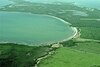 | Ceiba and Fajardo | 1918 | 352 | [29] | Mangrove forest, incl. the Medio Mundo and Daguao Protected Natural Area and the Ensenada Honda area. Bordered by Roosevelt Roads. [11] (B, F, G, K, O, P, S) |
| 6 | Cerrillos | 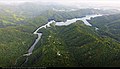 | Ponce | 1996 | 194 | [30] | Subtropical moist forest in the Cordillera Central foothills, surrounds Lake Cerrillos. (B, F, G, H, K, O, P, R, W) [31] |
| 7 | del Pueblo | 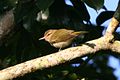 | Adjuntas | 1995 | 737 | [32] | Subtropical moist forest in the Cordillera Central. Important migratory passerine bird area. Officially one of the 20 state forests owned by the DRNA but this one is locally managed by the Taller de Arte y Cultura community-based group at Casa Pueblo. [33] (C, G, H, O, P, S, W) [33] |
| 8 | Guajataca | 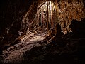 | Isabela | 1943 | 2,286 | [34] | Subtropical moist forest and mogotes (karstic hills) in the Northern Puerto Rico karst, home to numerous caves, canyons and sinkholes. [35] (C, G, H, O, P, W) |
| 9 | Guánica | 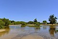 | Guánica, Guayanilla, Yauco, Peñuelas and Ponce [36] [37] | 1919 | 10,670 | [36] [37] | Largest protected tract of dry forest in the Caribbean, [13] also mangrove forests; home to endangered and endemic species (i.e. Puerto Rican crested toad). Incl. Punta Ballenas Natural Reserve and the Caña Gorda Cays. [12] Designated UNESCO Biosphere Reserve. [38] (G, H, K, O, P, R, S, W) |
| 10 | Guilarte | 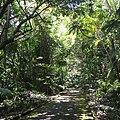 | Adjuntas, Peñuelas and Yauco | 1935 | 4,822 | [39] | Subtropical moist forest of the Cordillera Central, centered around Monte Guilarte. High density of endemic species, it is the last home of the rare and endangered Monte Guilarte hollyfern. [40] (G, H, O, W) |
| 11 | Los Tres Picachos | 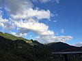 | Ciales and Jayuya [41] | 1999 | 2,289 | [42] | Subtropical moist forest of the Cordillera Central, centered around Los Tres Picachos. Important geological transition zone between the karst and cordillera geographical regions. [43] (H, O, W) [44] |
| 12 | Maricao | 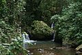 | Maricao, Sabana Grande, San Germán | 1919 | 10,478 | [45] | Second largest rainforest in the island after El Yunque National Forest. Centered around the Santa Ana Peak, also known as Monte del Estado. Incl. Monte del Estado ecological park and recreational areas, waterfalls and charcos, and the Maricao Fish Hatchery. [46] [14] (C, G, H, O, P, S, W) |
| 13 | Monte Choca | 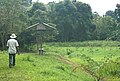 | Corozal [47] | 2003 | 238 | [48] | Tropical moist forest. Officially one of the 20 state forests owned by the DRNA but this one is locally managed by the Civic and Cultural Recreational Club of Palos Blancos. [49] (G, H, O, R, W) |
| 14 | Nuevo Milenio |  | San Juan | 1998 | 388 | [50] | Urban secondary forest. Research forest used to study the effects of hurricanes on tropical forests. Part of the Northern Puerto Rico karst and the San Juan Ecological Corridor. [51] Bordered by the University of Puerto Rico Botanical Garden. (R) |
| 15 | Piñones | 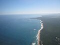 | Carolina and Loiza [52] | 1975 | 1,515 | [52] | Largest state-managed mangrove forest. Also, home to a subtropical forest, lagoons, sand dunes and marine ecosystems. Last home of the rare and endangered araña tree. [53] (C, G, K, O, P, R, S, W) |
| 16 | Rio Abajo |  | Arecibo and Utuado | 1943 | 5,607 | [54] | Subtropical moist forest and mogotes (karstic hills) in the Northern Puerto Rico karst, home to numerous caves and sinkholes. [55] Critical Puerto Rican parrot reintroduction area. [56] Designated a National Natural Landmark since 1980. [57] (G, H, O, R, W) |
| 17 | San Patricio |  | San Juan [58] | 2000 | 68 | [59] | Urban secondary forest centered around the Mogote de San Patricio. Research forest used to study reforestation in urban areas. Part of the Northern Puerto Rico karst. [60] (G, O, R, W) |
| 18 | Susúa | 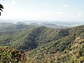 | Sabana Grande and Yauco | 1935 | 3,241 | [61] | Important transition zone between the tropical dry forest and the tropical rainforest in the foothills of the Cordillera Central. Home to the endangered Puerto Rican nightjar. [62] (G, H, O, P, R, W) |
| 19 | Toro Negro |  | Ciales, Jayuya, Juana Diaz, Orocovis and Ponce [63] | 1934 | 7,968 | [64] | Subtropical moist forest centered around the Toro Negro massif of the Cordillera Central that contains the highest peaks in Puerto Rico, including Cerro de Punta. [65] Incl. protected natural reserves and recreational areas. (B, C, F, G, H, K, O, P, S, W) [66] |
| 20 | Vega |  | Vega Alta and Vega Baja [67] | 1975 | 1,150 | [67] | Subtropical moist forest and mogotes (karstic hills) in the Northern Puerto Rico karst. Only a small section is open to the public. [68] (G, O, R, W) |
|


