The Puerto Rican dry forests are a tropical dry forest ecoregion located in southwestern and eastern Puerto Rico and on the offshore islands. They cover an area of 1,300 km2 (500 sq mi). These forests grow in areas receiving less than 1,000 mm (39 in) of rain annually. Many of the trees are deciduous, losing their leaves during the dry season which normally lasts from December to April.
The Guánica State Forest, popularly known as the Guánica Dry Forest is a subtropical dry forest located in southwest Puerto Rico. The area was designated as a forest reserve in 1919 and a United Nations Biosphere Reserve in 1981. It is considered the best preserved subtropical dry forest and the best example of dry forest in the Caribbean.

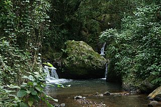
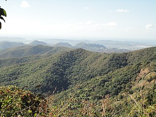
Toro Negro State Forest is one of the 21 forests that make up the public forests system in Puerto Rico. It is also Puerto Rico's highest cloud forest. It is in the Cordillera Central region of the island and covers 8,204 cuerdas, of mountains. Toro Negro's mountains have heights reaching up to 4,400 feet (1,300 m) and include Cerro de Punta, Cerro Jayuya and Cerro Rosa, the three highest peaks in the island. Nested among these mountains is Lake Guineo, the island's highest lake. The forest has 18 kilometers (11 mi) of trails, an observation tower, two natural swimming pools (Spanish:"charcos"), camping and picnic areas, nine rivers, and numerous creeks and waterfalls. The forest spans areas within the municipalities of Ponce, Jayuya, Orocovis, Ciales, and Juana Díaz, and consists of seven non-contiguous tracts of land. The largest contiguous segment of the forest is located in the municipalities of Ponce and Jayuya. Some 40% of the area of Toro Negro State Forest is located in Ponce's Barrio Anón.

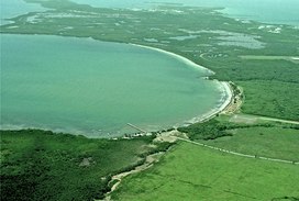
Cabo Rojo National Wildlife Refuge is an 1,836-acre National Wildlife Refuge located in southwestern Puerto Rico, in the municipality of Cabo Rojo. The refuge is a habitat for number of native bird species including the endangered yellow-shouldered blackbird, locally known as mariquita de Puerto Rico or capitán. Many birds find their way to the refuge while migrating between North and South America, and more than 118 bird species have been recorded near the area.
Maricao State Forest is a state forest located in the eastern Cordillera Central mountains of Puerto Rico. It is commonly known as Monte del Estado due to the fact that it was one of the first forest reserves in Puerto Rico to be designated a state forest in its official name. With an area of 10,803 acres (43.72 km2), the Maricao State Forest is the largest of the 20 forestry units of the Puerto Rico state forest system.
The Aguirre State Forest is a 2,393-acre (9.68 km2) nature reserve on the south coast of Puerto Rico and one of the commonwealth's 20 state forests. It mainly consists of mangroves and floodplain forests, and it borders the Jobos Bay National Estuarine Research Reserve. The Aguirre State Forest is owned and administered by Puerto Rico. It was established in 1918 by Puerto Rico governor Arthur Yager to protect the mangrove forests areas between the municipalities of Guayama and Santa Isabel.
Cambalache State Forest and Reserve is a nature reserve and one of the 20 state forests in the territory of Puerto Rico. The Cambalache State Forest is located in the municipalities of Arecibo and Barceloneta in northern Puerto Rico.

The Northeast Ecological Corridor Nature Reserve (NECNR) refers to an area designated as a protected Nature Reserve located on the northeast coast of Puerto Rico, between the municipalities of Luquillo and Fajardo. Specifically, the lands that comprise the NEC are located between Luquillo's town square to the west and Seven Seas Beach to the east, being delineated by PR Route # 3 to its south and the Atlantic Ocean to its north. It was decreed as a protected area by former Puerto Rico Governor Aníbal S. Acevedo-Vilá in April 2008, a decision reversed by Governor Luis G. Fortuño-Burset in October 2009, although he later passed a law in June 2012 re-designated as nature reserve two-thirds of its lands, after intense lobbying and public pressure. Later, in 2013, Governor Alejandro García-Padilla signed a law declaring all lands within the NEC a nature reserve. The area comprises 2,969.64 acres, which include such diverse habitats as forest, wetlands, beaches, coral communities, and a sporadically bioluminescent lagoon. The Corridor is also home to 866 species of flora and fauna, of which 54 are considered critical elements, meaning rare, threatened, endangered and endemic species classified by the Puerto Rico Department of Natural and Environmental Resources (DNER), some even designated as critically endangered by the International Union for Conservation of Nature and Natural Resources (IUCN). These include, among others, federally endangered species such as the plain pigeon, the snowy plover, the Puerto Rican boa, the hawksbill sea turtle and the West Indian manatee. The beaches along the NEC, which are 8.74 kilometers long are important nesting grounds for the leatherback sea turtle, which starts its nesting season around April each year.

Rio Abajo State Forest is a forest preserve in Puerto Rico owned by the Department of Natural Resources and one of the 20 state forests in the island. It was designated a National Natural Landmark in 1980 and constitutes an area of 3,590 acres. It consists mostly of subtropical wet and moist karst forest. Mogotes and sinkholes fill the landscape. The forest preserve is located in the municipalities of Arecibo and Utuado. In addition to its ecological value the forest also contains a number of archaeological sites.

Carite State Forest is a state forest and nature reserve located in the Sierra de Cayey mountain range in southeastern Puerto Rico. The forest extends over approximately 2,600 hectares and is located in the municipalities of Caguas, Cayey, Guayama, Patillas and San Lorenzo. The forest is located along the Ruta Panorámica, which offers access to the forest.

Guilarte State Forest is one of the 20 forests that make up the public forests system in Puerto Rico. The forest is located in the eastern half of the Central Mountain Range or Cordillera Central. The main geographical feature of the forest reserve is Monte Guilarte, which is Puerto Rico's 7th highest mountain at 3,950 feet above sea level. While Monte Guilarte is located in the municipality of Adjuntas, the forest's borders also include parts of Guayanilla, Peñuelas and Yauco.

San Patricio State Forest, also known as the San Patricio Urban Forest is one of the 20 forests that make up the public forest system of Puerto Rico. This is a secondary or second-growth forest is located in the Gobernador Piñero district of San Juan, between the neighborhoods of Villa Borinquen, Caparra Heights and Borinquen Towers complex. The urban forest has entrances on Roosevelt Avenue and Ensenada Street. The forest extends to almost 70 acres and it is the smallest protected area in the Puerto Rico state forest system. One of the most distinctive features of the forest is the mogote on its northern edge which can be observed from many parts of San Juan and Guaynabo. The forest is part of the Northern Karst.

Guajataca State Forest is one of the 20 forests that make up the public forest system of Puerto Rico. The Guajataca Forest is located in the northwestern part of Puerto Rico, along the Northern Karst zone in the municipality of Isabela and municipality of Quebradillas, and is near Camuy and San Sebastián. The forest is renowned for its ecological diversity, the mogotes and karstic formations, and its numerous caves and canyons. It also has the largest trail system of any Puerto Rican state forest.

Bosque del Pueblo is one of the 20 forest units that make up the public forest system of Puerto Rico. The 738-acres forest is located in the municipality of Adjuntas and it comprises a preserved zone which was endangered of being developed as a quarry between the years 1980 and 1995. The forest is located in lands shared by the Adjuntas barrios or districts of Vegas Arriba, Vegas Abajo and Pellejas de Adjuntas. In addition to preserving the forest, the reserve is important to the preservation of the hydrological basins of the Pellejas and Viví Rivers, and many of the tributaries of the Arecibo River have their sources in the forest lands. The forest also functions as an ecological corridor between the Guilarte, Río Abajo and Toro Negro Forests.
Susúa State Forest is one of the 20 forest units that make up the public forest system of Puerto Rico. This forest is located in the southeastern foothills of the Central Mountain Range or Cordillera Central, in the municipalities of Sabana Grande and Yauco. Most of the forest, particularly the lower parts, are of secondary growth as the land had originally been deforested and used for cattle grazing, timber production and agriculture. The forest is an important habitat for the endangered Puerto Rican nightjar.

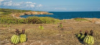
Boquerón State Forest is one of the 20 forestry units that make up the public forest system of Puerto Rico. Despite its name, the Boquerón State Forest is not only located in Boquerón, Cabo Rojo but also spans almost 5,000 acres across the municipalities of Cabo Rojo, Lajas and Mayagüez. The forest area is also known for its limestone cliffs, the lighthouse, and the salt flats which have been a source of salt since the pre-Hispanic era and, dating to 700 C.E., they are considered to be one of the oldest industries in the Americas.

La Cordillera Reef is a nature reserve located 1.5 nautical miles from Fajardo, Puerto Rico consisting of a small archipelago of keys, coral reefs and rocky islets. The nature reserve covers about 18 nautical miles and almost 30,000 acres between Cape San Juan in Cabezas, Fajardo and the island of Culebra. With the exception of Palomino and Lobos Key which are privately owned, all islands, reefs and keys are protected by the marine reserve. The total land area of the reserve is 224 cuerdas. The nature reserve is also important for local fishermen, and eastern coastal municipalities such as Fajardo, Ceiba and Naguabo depend on the reserve for their fishing industries.

Vega State Forest is a state forest of Puerto Rico located in the municipalities of Vega Alta and Vega Baja. The subtropical moist forest is located in the northern coast of Puerto Rico in the middle of the karst zone known as the Carso Norteño, and it contains features typical of such geography such as sinkholes, caves and mogotes. It was designated a nature reserve in 1952 and it is fully protected by the Puerto Rico Forest laws of 1975. The forest has a total area of 1,150 acres divided into six forest units throughout the municipalities of Vega Alta and Vega Baja.

Caja de Muertos Nature Reserve is a nature reserve in southern Puerto Rico consisting of the islands of Caja de Muertos, Cayo Morrillito, Cayo Berbería, and their surrounding reefs and waters in the Caribbean Sea. This nature reserve was founded on January 2, 1980, by the Puerto Rico Planning Board as recommended by the Puerto Rico Department of Natural and Environmental Resources with the purpose of preserving the subtropical dry forest ecosystems found within these islands, some important sea turtle nesting sites, and the marine habitats found on their surrounding reefs and waters.