| Cambalache Forest Reserve Spanish: Bosque Estatal de Cambalache | |
|---|---|
| Geography | |
| Location | Arecibo, Barceloneta |
| Area | 1,600 cuerdas (1,600 acres) |
| Administration | |
| Status | Public, Commonwealth |
| Governing body | Puerto Rico Department of Natural and Environmental Resources (DRNA) |
| Website | www |
| Ecology | |
| WWF Classification | Puerto Rican moist forests |
Cambalache State Forest and Reserve (Spanish: Bosque estatal de Cambalache, also referred to as Parque nacional de Cambalache) [1] is a nature reserve and one of the 20 state forests in the territory of Puerto Rico. [2] [3] The Cambalache State Forest is located in the municipalities of Arecibo and Barceloneta in northern Puerto Rico. [4]
The Cambalache State Forest was proclaimed in 1943 through a deal between the United States Forest Service and the Land Authority of Puerto Rico (Autoridad de Tierras) as part of a research program dedicated to the ecological and geological study of the island's Northern karst. The forest was first known as the Cambalache Experimental Forest. It was proclaimed a state forest in 1973. [4]
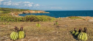
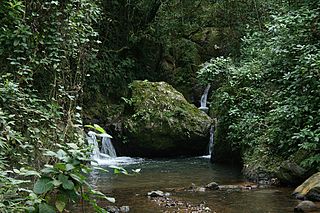
The forest reserve protects steep limestone hills known as mogotes, which are covered in patches of moist forests. The elevation ranges from 5 to 50 m (16 to 164 ft) above mean sea level. Average rainfall is 1,479.8 mm (58.26 in) per year, with the temperature varying from 23.3 to 27 °C (73.9 to 80.6 °F). Mogotes oriented northeast to southeast have humid northern and southwestern slopes but xeric tops. [5] It has an area of 1,050 cuerdas (about 1,019 acres). [6]
The forest is divided into various forest units located throughout the municipalities of Arecibo (Factor, Garrochales, Miraflores, Sabana Hoyos and La Mano Farm) and Barceloneta (Benero and Palenque Farms). [4]
More than 150 trees and large shrubs have been identified in the forest. Common trees include Cecropia, Schefflera, and Tabebuia heterophylla . The endemic Puerto Rican royal palm ( Roystonea borinquena ) and Palma de Sierra ( Gaussia attenuata ) are also found in the forest. Zanthoxylum martinicense inhabits xeric areas. [7] Eugenia biflora and Eugenia ligustrina are found in the forest. [8] The hillsides and valleys are home to distinct vegetation zones. The valleys have lost most of their original vegetation and instead feature scrubby secondary forests and planted teak groves. [5]
The forest is home to at least two endangered species: the Puerto Rican boa (Epicrates inornatus) and the red fruit bat ( Stenoderma rufum ). Some other animals found in the forest are the Puerto Rican lizard cuckoo ( Coccyzus vieilloti ), the Puerto Rican tody ( Todus mexicanus ), the green mango ( Anthracothorax viridis ), the Puerto Rican bullfinch ( Melopyrrha portoricensis ), the Puerto Rican oriole ( Icterus portoricensis ), and Adelaide's warbler ( Setophaga adelaidae ). There is also a large variety of butterfly species some of which are rare. [4]
Parts of the forest are open to visitors with opportunities for hiking, camping and biking. The visitors' area is located by highway PR-22. [9]

Barceloneta is a town and municipality in Puerto Rico located in the north region, bordering the Atlantic Ocean, north of Florida, east of Arecibo, and west of Manatí. Barceloneta is spread over 3 barrios and Barceloneta Pueblo. It is part of the San Juan-Caguas-Guaynabo Metropolitan Statistical Area.

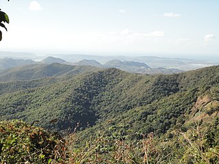
Cordillera Central, is the main mountain range in Puerto Rico. The range crosses the island from west to east and divides it into its northern and southern coastal plains. The Cordillera Central runs eastward from the municipality of Maricao in the west to Aibonito in the central eastern region, and on to the Caribbean in the southeast through the Sierra de Cayey. The Central Mountain Range consists of the Cordillera Central proper and numerous subranges, foothills and ridges that extend throughout the island. Cerro de Punta is both the highest peak of the Cordillera Central and the highest point in Puerto Rico. The Sierra de Luquillo, where El Yunque is located, is sometimes included as a subrange or eastward extension of the Cordillera Central.
The Guánica State Forest, popularly known as the Guánica Dry Forest is a subtropical dry forest located in southwest Puerto Rico. The area was designated as a forest reserve in 1919 and a United Nations Biosphere Reserve in 1981. It is considered the best preserved subtropical dry forest and the best example of dry forest in the Caribbean.

The San Juan Botanical Garden, officially known as the Botanical Garden of the University of Puerto Rico, is located in the Caribbean city of San Juan, capital of Puerto Rico. This lush 300-acre (1.2 km2) “urban garden” of native and exotic flora serves as a laboratory for the study, conservation and enrichment of plants, trees, flowers, grasses and many other plants. Seventy-five acres are landscaped and open to the general public as well as researchers.

Toro Negro State Forest is one of the 21 forests that make up the public forests system in Puerto Rico. It is also Puerto Rico's highest cloud forest. It is in the Cordillera Central region of the island and covers 8,204 cuerdas, of mountains. Toro Negro's mountains have heights reaching up to 4,400 feet (1,300 m) and include Cerro de Punta, Cerro Jayuya and Cerro Rosa, the three highest peaks in the island. Nested among these mountains is Lake Guineo, the island's highest lake. The forest has 18 kilometers (11 mi) of trails, an observation tower, two natural swimming pools (Spanish:"charcos"), camping and picnic areas, nine rivers, and numerous creeks and waterfalls. The forest spans areas within the municipalities of Ponce, Jayuya, Orocovis, Ciales, and Juana Díaz, and consists of seven non-contiguous tracts of land. The largest contiguous segment of the forest is located in the municipalities of Ponce and Jayuya. Some 40% of the area of Toro Negro State Forest is located in Ponce's Barrio Anón.
Maricao State Forest is a state forest located in the eastern Cordillera Central mountains of Puerto Rico. It is commonly known as Monte del Estado due to the fact that it was one of the first forest reserves in Puerto Rico to be designated a state forest in its official name. With an area of 10,803 acres (43.72 km2), the Maricao State Forest is the largest of the 20 forestry units of the Puerto Rico state forest system.

Rio Abajo State Forest is a forest preserve in Puerto Rico owned by the Department of Natural Resources and one of the 20 state forests in the island. It was designated a National Natural Landmark in 1980 and constitutes an area of 3,590 acres. It consists mostly of subtropical wet and moist karst forest. Mogotes and sinkholes fill the landscape. The forest preserve is located in the municipalities of Arecibo and Utuado. In addition to its ecological value the forest also contains a number of archaeological sites.

The Northern Karst is a limestone karst landscape located in the northern part of Puerto Rico. A karst is a topographical zone formed by the dissolution of soluble porous rocks, such as limestone, with features such as mogotes, canyons, caves, sinkholes, streams and rivers, all of which are common on this region of the island. Some of the island's main rivers, including its longest, traverse the karst and form some of the most distinctive Puerto Rican geographical features such as the Camuy caverns. Many of these rivers feed into and are important in the formation of many marshy areas such as the Caño Tiburones wetlands.

Carite State Forest is a state forest and nature reserve located in the Sierra de Cayey mountain range in southeastern Puerto Rico. The forest extends over approximately 6,500 acres and is located in the municipalities of Caguas, Cayey, Guayama, Patillas and San Lorenzo. The forest is located along the Ruta Panorámica, which offers access to the forest.

Guilarte State Forest is one of the 20 forests that make up the public forests system in Puerto Rico. The forest is located in the eastern half of the Central Mountain Range or Cordillera Central. The main geographical feature of the forest reserve is Monte Guilarte, which is Puerto Rico's 7th highest mountain at 3,950 feet above sea level. While Monte Guilarte is located in the municipality of Adjuntas, the forest's borders also include parts of Guayanilla, Peñuelas and Yauco.

Ceiba State Forest, also referred to as the Ceiba State Reserve, is a mangrove forest and nature reserve located in the eastern coast of Puerto Rico, in the municipalities of Ceiba and Fajardo. The forest extends over 350 acres and is mostly made of mangrove forests which are habitat to a large number of bird species. Although named Ceiba State Forest, the forest is not home to the large ceiba tree, and it is actually named after the municipality it is located in. In addition to the mangrove forests, the reserve also includes coastal zones that comprise sandy beaches and coral reefs found in both the Ceiba and Fajardo sections.
Los Tres Picachos State Forest is one of the 20 forests that make up the public forest system of Puerto Rico. The forest is located in the Central Mountain Range or Cordillera Central, along the Los Tres Picachos mountain ridge, one of the island's highest mountains, named after the distinctive three peaks of the highest mountain in the forest. The state forest is located in the municipalities of Jayuya and Ciales.

San Patricio State Forest, also known as the San Patricio Urban Forest is one of the 20 forests that make up the public forest system of Puerto Rico. This is a secondary or second-growth forest is located in the Gobernador Piñero district of San Juan, between the neighborhoods of Villa Borinquen, Caparra Heights and Borinquen Towers complex. The urban forest has entrances on Roosevelt Avenue and Ensenada Street. The forest extends to almost 70 acres and it is the smallest protected area in the Puerto Rico state forest system. One of the most distinctive features of the forest is the mogote on its northern edge which can be observed from many parts of San Juan and Guaynabo. The forest is part of the Northern Karst.

Nuevo Milenio State Forest is one of the 20 forests that make up the public forest system of Puerto Rico. The forest is located east of the University of Puerto Rico Botanical Garden in the Sabana Llana Sur district of San Juan, making it one of the two state forests located within the capital's municipal boundaries.

Guajataca State Forest is one of the 20 forests that make up the public forest system of Puerto Rico. The Guajataca Forest is located in the northwestern part of Puerto Rico, along the Northern Karst zone in the municipality of Isabela and municipality of Quebradillas, and is near Camuy and San Sebastián. The forest is renowned for its ecological diversity, the mogotes and karstic formations, and its numerous caves and canyons. It also has the largest trail system of any Puerto Rican state forest.

Bosque del Pueblo is one of the 20 forest units that make up the public forest system of Puerto Rico. The 738-acres forest is located in the municipality of Adjuntas and it comprises a preserved zone which was endangered of being developed as a quarry between the years 1980 and 1995. The forest is located in lands shared by the Adjuntas barrios or districts of Vegas Arriba, Vegas Abajo and Pellejas de Adjuntas. In addition to preserving the forest the reserve is important to the preservation of the hydrological basins of the Pellejas and Viví Rivers, and many of the tributaries of the Arecibo River have their sources in the forest lands. The forest also functions as an ecological corridor between the Guilarte, Río Abajo and Toro Negro Forests.
Susúa State Forest is one of the 20 forest units that make up the public forest system of Puerto Rico. This forest is located in the southeastern foothills of the Central Mountain Range or Cordillera Central, in the municipalities of Sabana Grande and Yauco. Most of the forest, particularly the lower parts, are of secondary growth as the land had originally been deforested and used for cattle grazing, timber production and agriculture. The forest is an important habitat for the endangered Puerto Rican nightjar.

Vega State Forest is a state forest of Puerto Rico located in the municipalities of Vega Alta and Vega Baja. The subtropical moist forest is located in the northern coast of Puerto Rico in the middle of the karst zone known as the Carso Norteño, and it contains features typical of such geography such as sinkholes, caves and mogotes. It was designated a nature reserve in 1952 and it is fully protected by the Puerto Rico Forest laws of 1975. The forest has a total area of 1,150 acres divided into six forest units throughout the municipalities of Vega Alta and Vega Baja.